
Order Total (1 Item Items):
Shipping Destination:

Winkles, H Engraver (5 results)
Skip to main search results
Product Type
- All Product Types
- Books (2)
- Magazines & Periodicals
- Comics
- Sheet Music
- Art, Prints & Posters (1)
- Photographs
- Maps (1)
-
Manuscripts &
Paper Collectibles (1)
Condition
Binding
- All Bindings
- Hardcover (1)
- Softcover
Collectible Attributes
- First Edition
- Signed
- Dust Jacket
- Seller-Supplied Images (4)
- Not Printed On Demand (4)
Free Shipping
Seller Location
Seller Rating
-
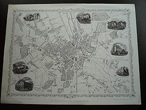
Map: Bradford, Yorkshire.
Published by The London Printing and Publishing Company, London. N.d. (1880s) (1960s)., 1960
Map
No Binding. Condition: Fine. Limited Edition. Reproduction plan or map of Bradford in Fine condition, 1 page, large quarto. The plan was drawn and engraved by J. Rapkin and the illustrations drawn and engraved by H. Winkles. Probably from the 1880s. Has 7 illustrations with the plan of churches, Infirmary, Terminus of the Bradford and Halifax Railway. Overall size is 14"x10.5". Ideal for framing.
-
![Seller image for Barber's picturesque illustrations, of the Isle of Wight : comprising views of every object of interest on the island : engraved from original drawings, accompanied by historical and topographical descriptions [LeatherBound] for sale by True World of Books](https://pictures.abebooks.com/inventory/md/md31534454468.jpg)
LeatherBound. Condition: New. LeatherBound edition. Condition: New. Reprinted from 1834 edition. Leather Binding on Spine and Corners with Golden leaf printing on spine. Bound in genuine leather with Satin ribbon page markers and Spine with raised gilt bands. A perfect gift for your loved ones. NO changes have been made to the original text. This is NOT a retyped or an ocr'd reprint. Illustrations, Index, if any, are included in black and white. Each page is checked manually before printing. As this print on demand book is reprinted from a very old book, there could be some missing or flawed pages, but we always try to make the book as complete as possible. Fold-outs, if any, are not part of the book. If the original book was published in multiple volumes then this reprint is of only one volume, not the whole set. Sewing binding for longer life, where the book block is actually sewn (smythe sewn/section sewn) with thread before binding which results in a more durable type of binding. Pages: 300 Language: English.
-
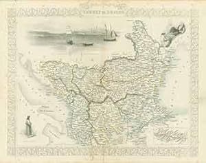
Turkey in Europe (Map).
Published by London: London Printing And Publishing Company, [1860s - 1890s?]., 1890
Manuscript / Paper Collectible
Condition: Good. 11 x 14 inches. Very Good. Minor foxing. Folded, hand-colored map of Turkey in Europe.
-

POLYNESIA, OR ISLANDS IN THE PACIFIC OCEAN
Published by John Tallis & Company, London & New York
Book
No Binding. Condition: Near Fine. H. Winkles [Illustrator]; T. Wrightson [Engraver] (illustrator). Undated on map but 1851. Steel engraved map with outlines in red of part of the coastlines of Australia, Nippon [Japan] and the United States colour as well as some of the very small Pacific islands. Four vignettes - Resolution Bay [Marquesas]; Kalakakooa, Sandwich Islands ; Otaheite; Harbour of Dory, New Guinea. Overall size, With margins - 35.5cm by 28cm. Vertical fold at center. Clean and unmarked, no damage. Image available. Postage at cost - options available.
-

Quasimodo, the Hunchback of Notre-Dame. (B&W engraving).
Published by London: Smith, Elder & Co., [1800s]., 1800
Art / Print / Poster
Condition: Good. Original B&W gravure. 10.5 x 8 inches. Very Good+. Scarce.
