
Order Total (1 Item Items):
Shipping Destination:

Mercator, Gerard (703 results)
Skip to main search results
Product Type
- All Product Types
- Books (194)
- Magazines & Periodicals
- Comics
- Sheet Music
- Art, Prints & Posters (166)
- Photographs
- Maps (343)
-
Manuscripts &
Paper Collectibles
Condition
Binding
Collectible Attributes
- First Edition (26)
- Signed (27)
- Dust Jacket (6)
- Seller-Supplied Images (504)
- Not Printed On Demand (701)
Free Shipping
Seller Location
Seller Rating
-
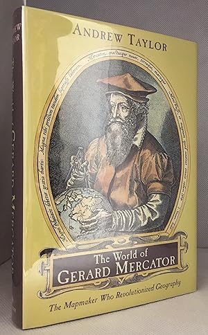
The World of Gerard Mercator; The Mapmaker Who Revolutionized Geography
Published by Walker & Company, New York
ISBN 10: 0802713777ISBN 13: 9780802713773
Seller: Burton Lysecki Books, ABAC/ILAB, Winnipeg, MB, Canada
Seller Rating:

Book
[0-8027-1377-7] 2004. (Hardcover) Near fine in fine dust jacket. 291pp. Illustrations, maps, notes, bibliography, index. "The story of discovery and mapmaking is one of pushing back shadows, and no one in the last two thousand years achieved as much as Gerard Mercator in extending the boundaries of the known world. His life spanned most of the turbulent, extraordinary sixteenth century". Biography of Gerard Mercator. Time Period 16th Century. (Travel, Cartographers, Cartography, Geography, Mapmaking, Navigation, Travel).
More buying choices from other sellers on AbeBooks
New offers from � 32.08
Used offers from � 21.59
Also find Hardcover
-
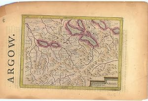
Argow (Aargau).
Published by LondonPrinted by T.Cotes for Michael Sparkes and Samuel Cartwright ., 1635
Seller: Robert Frew Ltd. ABA ILAB, London, United Kingdom
Association Member: ABA ILAB PBFA
Seller Rating:
Map
Original engraved map of Argau / Switzerland (map dimensions 19.2 x 14 cm, overall dimensions 29.5 x 18.5 cm) with later hand-colouring. Covering the area around the Lake Lucerne, Lake Zurich and Lake Thun. With English text to verso. A bit tanned and with a few small nicks to margins, generally very good. From "Historia Mundi or Mercator's Atlas .".
-
![Seller image for Chronologia. Hoc est temporum demonstratio exactissima, ab initio mundi, vsque ad annum Domini 1568. Ex eclipsibus et obseruationibus astronomicis omnium temporum, sacris quoque Biblijs, . summa fide concinnata. Auctore Gerardo Mercatore, . cosmographo (1569) [LeatherBound] for sale by True World of Books](https://pictures.abebooks.com/inventory/md/md31657258588.jpg)
Chronologia. Hoc est temporum demonstratio exactissima, ab initio mundi, vsque ad annum Domini 1568. Ex eclipsibus et obseruationibus astronomicis omnium temporum, sacris quoque Biblijs, . summa fide concinnata. Auctore Gerardo Mercatore, . cosmographo (1569) [LeatherBound]
Publication Date: 2023
Book Print on Demand
LeatherBound. Condition: New. LeatherBound edition. Condition: New. Reprinted from 1569 edition. Leather Binding on Spine and Corners with Golden leaf printing on spine. Bound in genuine leather with Satin ribbon page markers and Spine with raised gilt bands. A perfect gift for your loved ones. NO changes have been made to the original text. This is NOT a retyped or an ocr'd reprint. Illustrations, Index, if any, are included in black and white. Each page is checked manually before printing. As this print on demand book is reprinted from a very old book, there could be some missing or flawed pages, but we always try to make the book as complete as possible. Fold-outs, if any, are not part of the book. If the original book was published in multiple volumes then this reprint is of only one volume, not the whole set. Sewing binding for longer life, where the book block is actually sewn (smythe sewn/section sewn) with thread before binding which results in a more durable type of binding. Pages: 493 Gerard Mercator.
-
Museum Plantin-Moretus/Stedelijk prentenkabinet Antwerpen, 1994. Paperback / Softcover. 30 x 21 cm. With illustrations in color and b/w. 175 pages. Text in French and Dutch. FINE COPY [ Cartography / cartografie ].
-
![Seller image for Atlas minor Gerardi Mercatoris a I. Hondio plurimis aeneis tabulis auctus et illustratus denuo recognitus, additisque novis delineationibus emendatus (1628) [LeatherBound] for sale by True World of Books](https://pictures.abebooks.com/inventory/md/md31657476770.jpg)
LeatherBound. Condition: New. LeatherBound edition. Condition: New. Reprinted from 1628 edition. Leather Binding on Spine and Corners with Golden leaf printing on spine. Bound in genuine leather with Satin ribbon page markers and Spine with raised gilt bands. A perfect gift for your loved ones. NO changes have been made to the original text. This is NOT a retyped or an ocr'd reprint. Illustrations, Index, if any, are included in black and white. Each page is checked manually before printing. As this print on demand book is reprinted from a very old book, there could be some missing or flawed pages, but we always try to make the book as complete as possible. Fold-outs, if any, are not part of the book. If the original book was published in multiple volumes then this reprint is of only one volume, not the whole set. Sewing binding for longer life, where the book block is actually sewn (smythe sewn/section sewn) with thread before binding which results in a more durable type of binding. Pages: 645 Gerard Mercator.
-

Mercator. De man die de aarde in kaart bracht. Vertaald door Jos den Bekker.
Seller: Antiquariaat A. Kok & Zn. B.V., Amsterdam, Netherlands
Seller Rating:
Amst., 2003. 364,[1] pp. Col. & b./w. ills. Orig. hardcover, d./j.
-
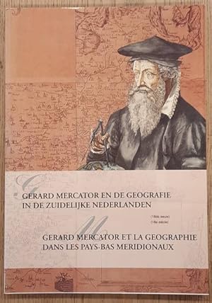
Gerard Mercator en de geografie in de Zuidelijke Nederlanden. (16e eeuw) / Gerard Mercator et la geographie dans les Pays-Bas meridionaux. (16e si�cle).
Seller: Antiquariaat A. Kok & Zn. B.V., Amsterdam, Netherlands
Seller Rating:
Antwerpen, 1994. 175 pp. Col. & b./w. ills. Softcover. (Publicaties van het Museum Plantin-Moretus en het Stedelijk Prentenkabinet, nr. 29).Text in Dutch & French. - Exhibition catalogue.
-
Gerard Mercator en de geografie in de zuidelijke Nederlanden (16de eeuw) / Gerard Mercator et la geographie dans les Pays-Bas meridionaux (16e si�cle)
Published by Antwerpen, Stad 1994, 1994
175 p. Paperback.
-

THE WORLD OF GERARD MERCATOR: The Mapmaker Who Revolutionised Geography
Published by HarperCollinsPublishers, London, 2004
Seller: Kay Craddock - Antiquarian Bookseller, Melbourne, VIC, Australia
Association Member: ANZAAB ILAB
Seller Rating:
First Edition
Pp. xii+292(last blank), pictorial double title page, text illustrations, notes, bibliography, index; demy 8vo; green boards, spine lettered in gilt; dust wrapper, slightly foxed; book label of David Levine, Sydney, on upper pastedown, edges of leaves slightly foxed; HarperCollinsPublishers, London, 2004. First edition.
-
Bruxelles, Cre dit Communal, 1994. 157 pp. Col. & b./w. ills. Softcover. - Stamp on half-title.Contribution in French by various authors.
-
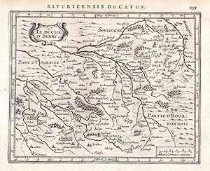
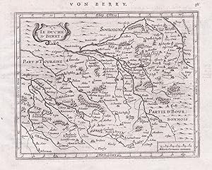
Le Duche d'Berry" - Touraine Tours Bourges Sologne Frankreich France map Gerard Mercator
Published by Amsterdam, Janssonius, 1628
Seller: Antiquariat Steffen V�lkel GmbH, Seubersdorf, Germany
Seller Rating:
Art / Print / Poster
Original Kupferstich-Karte von 1628 aus "Atlas Minor" von Gerard Mercator - aus der Lateinischen Ausgabe - Blatt-Ma�e: ca. 23,5 x 18 cm - teils leicht fleckig - sonst gut erhalten. -- Original engraving map of 1628 from "Atlas Minor" by Gerard Mercator's - from the Latin edition - slightly stained - otherwise in good condition. | Dies ist ein Original! - Kein Nachdruck! - Keine Kopie! -- This is an original! - No copy! - No reprint! la Gewicht in Gramm: 10.
-
Le Duche d'Berry" - Touraine Tours Bourges Sologne Frankreich France map Gerard Mercator
Published by Amsterdam, Janssonius, 1651
Seller: Antiquariat Steffen V�lkel GmbH, Seubersdorf, Germany
Seller Rating:
Art / Print / Poster
Blatt-Ma�e: ca. 17,5 x 23 cm -- Original Kupferstich-Karte von Gerard Mercator. R�ckseitig mit deutschem Text. Aus der deutschen Ausgabe des "Atlas Minor" von 1651. - gut erhalten. || Rare original copper engraved map by Gerard Mercator. With German text on verso. From the German edition of the "Atas Minor" from the year 1651. -- in very good condition. || The Flemish engraver and cartographer Jodocus Hondius (1563 1612), bought Mercator's plates after his death, and published this reduced version of Mercator's folio "Atlas sive Cosmographis", and added some 36 of his own maps - a "pocketversion" - "Atlas Minor" - which Hondius published together with his partners Cornelius Claesz and Johannes Janssonius. It became a large success, and was translated into several languages and issued in c. 40 editions. la Gewicht in Gramm: 10.
-
Gerard Mercator en de Geografie in de Zuidelijke Nederlanden (16de eeuw) / Gerard Mercator et la Geographie dans les Pays-Bas Meridionaux (16e si�cle)
Published by Antwerpen, Stad, 1994
Book
Soft cover. Condition: Fine. Text in Dutch and French; beautiful book! Owner's name inside cover is only flaw. Otherwise new. Exhibition Catalogue.
-
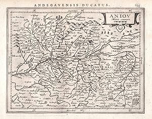
Aniou" - Mauges Saumur Angers Anjou Nantes Frankreich France map Gerard Mercator
Published by Amsterdam, Janssonius, 1628
Seller: Antiquariat Steffen V�lkel GmbH, Seubersdorf, Germany
Seller Rating:
Art / Print / Poster
Original Kupferstich-Karte von 1628 aus "Atlas Minor" von Gerard Mercator - aus der Lateinischen Ausgabe - Blatt-Ma�e: ca. 23,5 x 18 cm - gut erhalten. -- Original engraving map of 1628 from "Atlas Minor" by Gerard Mercator's - from the Latin edition - good condition. | Dies ist ein Original! - Kein Nachdruck! - Keine Kopie! -- This is an original! - No copy! - No reprint! la Gewicht in Gramm: 10.
-
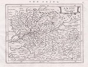
Aniou" - Mauges Saumur Angers Anjou Nantes Frankreich France map Gerard Mercator
Published by Amsterdam, Janssonius, 1651
Seller: Antiquariat Steffen V�lkel GmbH, Seubersdorf, Germany
Seller Rating:
Art / Print / Poster
Blatt-Ma�e: ca. 17,5 x 23 cm -- Original Kupferstich-Karte von Gerard Mercator. R�ckseitig mit deutschem Text. Aus der deutschen Ausgabe des "Atlas Minor" von 1651. - gut erhalten. || Rare original copper engraved map by Gerard Mercator. With German text on verso. From the German edition of the "Atas Minor" from the year 1651. -- in very good condition. || The Flemish engraver and cartographer Jodocus Hondius (1563 1612), bought Mercator's plates after his death, and published this reduced version of Mercator's folio "Atlas sive Cosmographis", and added some 36 of his own maps - a "pocketversion" - "Atlas Minor" - which Hondius published together with his partners Cornelius Claesz and Johannes Janssonius. It became a large success, and was translated into several languages and issued in c. 40 editions. la Gewicht in Gramm: 10.
-
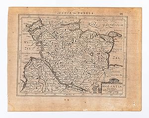
Holsatia ducatus.
Published by AmsterdamJansson., 1634
Seller: Robert Frew Ltd. ABA ILAB, London, United Kingdom
Association Member: ABA ILAB PBFA
Seller Rating:
Map
14.5 x 19.2 cm. Uncoloured. Single page map of Schleswig Holstein. Latin text on verso. Two very small holes to lower right margin though not affecting image. Generally in very good condition.
-
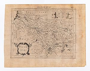
Picardia.
Published by AmsterdamJansson., 1634
Seller: Robert Frew Ltd. ABA ILAB, London, United Kingdom
Association Member: ABA ILAB PBFA
Seller Rating:
Map
14.5 x 18.7 cm. Uncoloured. Single page map of Picardy. Latin text on verso. Impression weaker at upper right corner. Some light soiling at margins, otherwise in good condition.
-

Bolonia et Guines com.
Published by AmsterdamJansson., 1634
Seller: Robert Frew Ltd. ABA ILAB, London, United Kingdom
Association Member: ABA ILAB PBFA
Seller Rating:
Map
14.6 x 18 cm. Uncoloured. Single page map of the region surrounding Boulogne. Latin text on verso. Small red mark to centre right of image. Some show through text, otherwise in good condition.
-
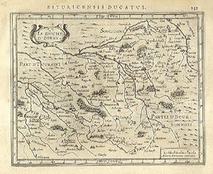
Le Duche D' Berry.
Published by AmsterdamJansson., 1634
Seller: Robert Frew Ltd. ABA ILAB, London, United Kingdom
Association Member: ABA ILAB PBFA
Seller Rating:
Map
14.4 x 18.1 cm. Uncoloured. Single page map. Latin text on verso. Very good condition.
-
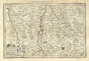
Lotharingia Septentrional.
Published by AmsterdamJansson., 1634
Seller: Robert Frew Ltd. ABA ILAB, London, United Kingdom
Association Member: ABA ILAB PBFA
Seller Rating:
Map
13.4 x 20.2 cm. Uncoloured. Single page map of northern Lorraine. Latin text on verso. Very good condition.
-
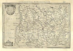
Lotharingia Meridionalis.
Published by AmsterdamJansson., 1634
Seller: Robert Frew Ltd. ABA ILAB, London, United Kingdom
Association Member: ABA ILAB PBFA
Seller Rating:
Map
13.4 x 19.9 cm. Uncoloured. Single page map of southern Lorraine. Latin text on verso. Light dampstain at upper left corner, otherwise in good condition.
-
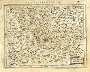
Westphali� tabula. II.
Published by AmsterdamJansson., 1634
Seller: Robert Frew Ltd. ABA ILAB, London, United Kingdom
Association Member: ABA ILAB PBFA
Seller Rating:
Map
13.7 x 17.7 cm. Uncoloured. Single page map of Westfalen and the Nord Rhein. Latin text on verso. Dampstaining across upper and right edges of sheet.
-
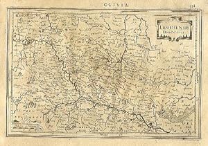
Leodiensis Diocesis.
Published by AmsterdamJansson., 1634
Seller: Robert Frew Ltd. ABA ILAB, London, United Kingdom
Association Member: ABA ILAB PBFA
Seller Rating:
Map
13.3 x 20 cm. Uncoloured. Single page map of the region of Liege. Latin text on verso. Light dampstain across sheet, otherwise browned overall.
-
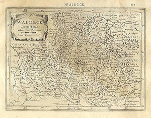
Waldeck Comitatus.
Published by AmsterdamJansson., 1634
Seller: Robert Frew Ltd. ABA ILAB, London, United Kingdom
Association Member: ABA ILAB PBFA
Seller Rating:
Map
14.2 x 19.3 cm. Uncoloured. Single page map of the region surrounding Waldeck, northern Hessen. Latin text on verso. Light dampstain across upper and right edges of sheet.
-
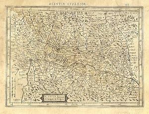
Alsatia superior cu Suntgoia & Brisgoia.
Published by AmsterdamJansson., 1634
Seller: Robert Frew Ltd. ABA ILAB, London, United Kingdom
Association Member: ABA ILAB PBFA
Seller Rating:
Map
14 x 19.1 cm. Uncoloured. Single page map of southern Alsace. Latin text on verso. Dampstain across upper and right edges of sheet, browned overall.
-
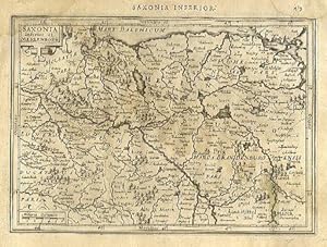
Saxonia Inferior et Meklenborg.
Published by AmsterdamJansson., 1634
Seller: Robert Frew Ltd. ABA ILAB, London, United Kingdom
Association Member: ABA ILAB PBFA
Seller Rating:
Map
14.2 x 20 cm. Uncoloured. Single page map showing what are now the regions of Schwerin, Rostock and Neubrandenburg. Latin text on verso. Dampstain across upper and right edges of sheet, browned overall.
-
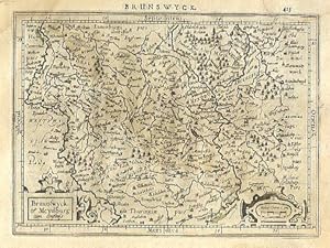
Braunswyck et Meydburg cum confinis.
Published by AmsterdamJansson., 1634
Seller: Robert Frew Ltd. ABA ILAB, London, United Kingdom
Association Member: ABA ILAB PBFA
Seller Rating:
Map
14.1 x 19.3 cm. Uncoloured. Single page map of the regions of Braunschweig and Magdeburg. Latin text on verso. Dampstain across upper and right edges of sheet, browned overall.
-
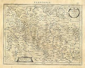
Franckenland.
Published by AmsterdamJansson., 1634
Seller: Robert Frew Ltd. ABA ILAB, London, United Kingdom
Association Member: ABA ILAB PBFA
Seller Rating:
Map
14 x 18.2 cm. Uncoloured. Single page map. Many place names underlined in pencil in an old hand. Latin text on verso. Light dampstain across upper and right edges of sheet, browned overall.
-
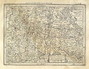
Palatinatus Bavariae.
Published by AmsterdamJansson., 1634
Seller: Robert Frew Ltd. ABA ILAB, London, United Kingdom
Association Member: ABA ILAB PBFA
Seller Rating:
Map
13.8 x 18.3 cm. Uncoloured. Single page map. Latin text on verso. Dampstain across upper and right edges of sheet, browned overall.
-
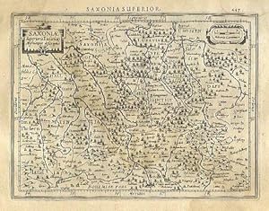
Saxoni� Superioris Lusati� Misnieque descriptio.
Published by AmsterdamJansson., 1634
Seller: Robert Frew Ltd. ABA ILAB, London, United Kingdom
Association Member: ABA ILAB PBFA
Seller Rating:
Map
13.6 x 18.2 cm. Uncoloured. Single page map of Saxony and the surrounding regions. Latin text on verso. Dampstain across upper and right edges of sheet, browned overall.
