
Order Total (1 Item Items):
Shipping Destination:

Jaillot, Bernard Antoine (5 results)
Skip to main search results
Product Type
- All Product Types
- Books (2)
- Magazines & Periodicals
- Comics
- Sheet Music
- Art, Prints & Posters (1)
- Photographs
- Maps (2)
-
Manuscripts &
Paper Collectibles
Condition
- All Conditions
- New
- Used
Binding
- All Bindings
- Hardcover
- Softcover (1)
Collectible Attributes
- First Edition
- Signed
- Dust Jacket
- Seller-Supplied Images (4)
- Not Printed On Demand
Seller Location
Seller Rating
-
![Seller image for Gouvernement Général de Guienne et Gascogne dédié au Roy, Dressé sur les Mémoires et Nouvelles Observations de Messieurs de l'Accadémie Royalle des Sciences. [ Carte - Partie Nord ] for sale by Librairie du Cardinal](https://pictures.abebooks.com/inventory/md/md2857392931.jpg)
souple. Gouvernement Général de Guienne et Gascogne dédié au Roy, Dressé sur les Mémoires et Nouvelles Observations de Messieurs de l'Accadémie Royalle des Sciences, par son trčs humble et trčs Obeissant, trčs fidel sujet et Serviteur Bernard Antoine Jaillot, Geogr. Ordr. de Sa Majesté, Quay des Grands Augustins, carte au format 100 x 50,5 cm, en deux feuilles jointes, frontičres et villes rehaussée ŕ l'aquarelle, Paris, 1733 Partie Nord seule (en deux feuilles) de la Carte de la Gascogne en 4 feuilles. Elle se développe de l'Isle de Ré ŕ Biscarosse et de Montluçon de Bourbonnais ŕ Marvejols. Bon état. Langue: Français.
-

Carte particulierede l' Isle de Corse divisée par ses Dix Province ou Juriditions et ses quatre Fiefs Levée sur les lieux par les ordres de la Republique de geni et mise au jour par le Sr. Bernard Antoine Jaillot géeographe ord.re. du Roy.
Published by Venezia, Santini & Remondini, 1775, 1775
Seller: TABERNA LIBRARIA - ALAI - ILAB, Pistoia, Italy
Seller Rating:

Acquaforte cm. 47,5x56,6 alla battuta + piccoli marg. bianchi. Acquarellatura coeva del cartiglio e dei confiniDall' "Atlas Universel" stampato a Venezia nel 1776 e nel 1784. Lievi lavoretti di tarlo restaurati al marg. inf.
-
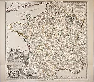
Condition: A. Belle carte des postes de France réalisée par Bernard Antoine Jaillot.Initialement créée en 1748, la carte ŕ subit un grand nombre de correction comme l'indique la mention au bas de la carte. L'évolution des cartes du réseau postal permet de mettre en lumičre les choix territoriaux issus d'impératifs, politiques ou économiques. Ce maillage constitue le premier systčme d'échange géré par la monarchie française dans les limites du territoire national.La carte est dédiée ŕ Antoine-Louis Rouillé, comte de Jouy, (1689 - 1761), homme d'État français. Il est d'abord nommé secrétaire d'État de la Marine (1749-1754), puis ministre français des Affaires étrangčres (1754-1757). // ENGLISH // 1757 edition of Bernard Antoine Jaillot map of the post office of France.Initially created in 1748, the map has undergone a large number of corrections as indicated by the mention at the bottom of the map. The evolution of the maps of the postal network allows to highlight the territorial choices resulting from political or economic imperatives. This network constitutes the first exchange system managed by the French monarchy within the limits of the national territory.The map is dedicated to Antoine-Louis Rouillé, comte de Jouy, (1689 - 1761), French statesman. He was first appointed Secretary of State for the Navy (1749-1754), then French Minister of Foreign Affairs (1754-1757).
-
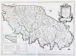
Carte Particuliere de l'Isle de Corse divisée par ses Dix Provinces ou Juridictions et ses quatre Fiefs" - Corse Corsica Korsika Insel ile island carte gravure
Published by Venezia, Santini & Remondini ca. 1779., 1779
Seller: Antiquariat Steffen Völkel GmbH, Seubersdorf, Germany
Seller Rating:

Map
Großformatige altkolorierte Kupferstich-Karte von ca. 1779. -- Blatt-Maße: ca. 52 x 74 cm. -- gut erhalten. || Large old colored engraved map from ca. 17797. -- in very good condition. || Francesco Santini was a Venetian publisher. He acquired the printing plates of Vaugondy's Atlas Universel, a commercial and cartographic success, with widespread influence on mapmakers throughout Europe. Together with his brother Paolo, he commissioned a new set of plates and reissued the atlas in 1776. In the following years, Paolo Santini assigned all his publication rights to M. Remondini, who in 1777 reissued the same atlas, but with his name. || Dies ist ein Original! - Kein Nachdruck! - Keine Kopie! -- This is an original! - No copy! - No reprint! Sprache: Französisch Gewicht in Gramm: 550.
-
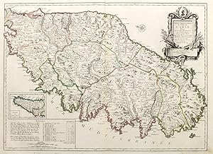
Carte particuliere de l'isle de Corse.
Published by Remondini, Venezia, 1780
Seller: libreria antiquaria perini Sas di Perini, Verona, VR, Italy
Seller Rating:
Art / Print / Poster
Incisione in rame, colorata d'epoca ai confini, mm 478x655. Edizione veneziana della carta di Jaillot, tratta da "Atlas Universel" stampato a Venezia fra il 1776 ed il 1784. Esemplare perfetto. Copperplate, original outline color, mm 478x655. Venitian edition of Jaillot's map; from "Atlas universel" printed in 1776-84. Perfect example. Nr.cat: cod. 2916.
