
Order Total (1 Item Items):
Shipping Destination:

J B Nolin (23 results)
Skip to main search results
Product Type
- All Product Types
- Books (12)
- Magazines & Periodicals
- Comics
- Sheet Music
- Art, Prints & Posters (2)
- Photographs
- Maps (9)
-
Manuscripts &
Paper Collectibles
Condition
- All Conditions
- New
- Used
Binding
- All Bindings
- Hardcover
- Softcover (5)
Collectible Attributes
- First Edition (3)
- Signed
- Dust Jacket
- Seller-Supplied Images (14)
- Not Printed On Demand
Seller Location
Seller Rating
-

Bulletin de psychologie n°446 Tome 53 (2) mars-avril 2000
Published by Bulletin de psychologie, Paris, 2000
Broché. Condition: Etat satisfaisant. in-8 Pages 164-288. Couverture salie et frottée avec une pliure. Langue : Français Nb de volumes : 1.
-
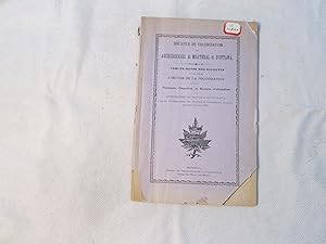
Soft cover. Condition: Good. No Jacket. M., Bureau du Prédicateur de la Colonisation, 1888. Non paginé, feuillet d errata. Couvertures souples d origine, accrocs et pertes au dos et aux extrémités des plats, étiquette de cote sur le 1er plat, cachets. Bonne condition.
-
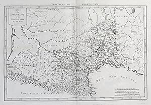
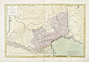
Carte du Languedoc et du Roussillon." - Langueduc Roussillon Nolin France carte Karte map
Published by Paris, 1787
Seller: Antiquariat Steffen Völkel GmbH, Seubersdorf, Germany
Seller Rating:

Map
Sehr seltene Kupferstich-Karte von Philippe de Pretot aus seinem Atlas Universelle aus dem Jahre 1787. -- Blatt-Maße: ca. 29 x 44 cm. -- gut erhalten. || Very rare copper engraved map by Philippe de Pretot from his Atlas Universelle from 1787. -- in good condition. Sprache: Französisch Gewicht in Gramm: 1550.
-
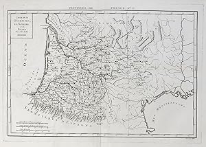
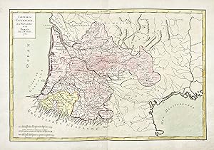
Carte de la Guienne, de la Navarre et du Bearn." - Guyenne Navarre Bearn Bordeaux Bayonne France carte Karte map
Published by Paris, 1787
Seller: Antiquariat Steffen Völkel GmbH, Seubersdorf, Germany
Seller Rating:
Map
Sehr seltene Kupferstich-Karte von Philippe de Pretot aus seinem Atlas Universelle" aus dem Jahre 1787. -- Blatt-Maße: ca. 33,5 x 49 cm. -- gut erhalten. || Very rare copper engraved map by Philippe de Pretot out of his Atlas Universelle" from 1787. -- in good condition. Sprache: Französisch Gewicht in Gramm: 1550.
-
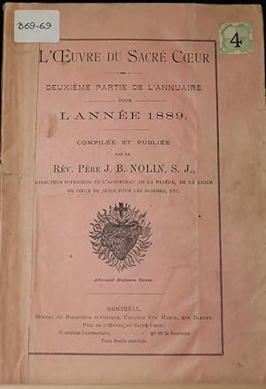
L'Oeuvre du Sacré-Coeur. Deuxičme partie de l'annuaire pour l'année 1889
Published by Bureau du directeur supérieur, Collčge Ste-Marie, Montréal, 1889
Seller: Librairie Michel Morisset, (CLAQ, ABAC, ILAB), Magog, QC, Canada
Seller Rating:
Book First Edition
Couverture souple. Condition: Bon. Edition originale. brochure, couv. légčrement abimées, 89 (2) p. 21 cm., petite étiquette sur le coin droit de la couv.Intéressant annuaire contenant des statistiques de l'oeuvre dans les paroisses. Peu commun. Pas dans BQ.
-
Carte du Languedoc et du Roussillon." - Langueduc Roussillon Nolin France carte Karte map
Published by Paris, 1762
Seller: Antiquariat Steffen Völkel GmbH, Seubersdorf, Germany
Seller Rating:
Map
Seltene altkolorierte Kupferstich-Karte von E.A. Philippe de Pretot. -- Blatt-Maße: ca. 31 x 46 cm. -- gut erhalten. || Rare hand colored engraved map by E.A. Philippe de Pretot. -- in very good condition. Sprache: Französisch Gewicht in Gramm: 1550.
-
Carte de la Guienne, de la Navarre et du Bearn." - Guyenne Navarre Bearn Bordeaux Bayonne France carte Karte map
Published by Paris, 1762
Seller: Antiquariat Steffen Völkel GmbH, Seubersdorf, Germany
Seller Rating:
Map
Seltene altkolorierte Kupferstich-Karte von E.A. Philippe de Pretot. -- Blatt-Maße: ca. 31 x 46 cm. -- gut erhalten. || Rare hand colored engraved map by E.A. Philippe de Pretot. -- in very good condition. Sprache: Französisch Gewicht in Gramm: 1550.
-

Le Petit Canadien: Organe de la Societe Saint-Jean-Baptiste de Montreal. 1917, Volume 15, Numbers 1-12 (full run)
Published by Societe Saint-Jean-Baptiste de Montreal, Montreal, 1917
Paperback. Condition: VG+. Original Issues. Stapled wraps, minor mild wear, most issues very good plus. Scarce Canadiana periodical, origial issue. Shipping to Canda would be $17.00, a refund will be issued for overpayment. Questions welcome. Images can be made upon request.
-
SOUTH AMERICA - an Original Antique Engraved Map, Printed c1756, Hand-Coloured
Publication Date: 1756
Seller: K Books Ltd ABA ILAB, York, YORKS, United Kingdom
Association Member: ABA ILAB PBFA
Seller Rating:
Book
No Binding. Condition: Very Good. J B NOLIN (illustrator). A splendid original antique engraved map. Hand-coloured, colouring not contemporary but delicately and expertly executed. Mounted - matted - and ready to frame . Very good condition. Printed c1756. A fine map showing the whole of the South American continent, very detailed, excellent condition, fine colouring.
-
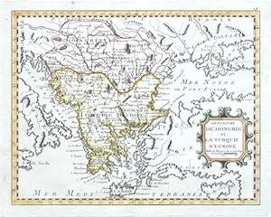
Le Royaume de Hongrie et la Turquie d'Europe
Published by Paris, 1783
"Le Royaume de Hongrie et la Turquie d'Europe". Orig. copperplate engraving after J. B. Nolin's map of the region. Published by L. J. Mondhare in Paris, 1783. Orig. old colouring. With ornamental title-cartouche. 20,5:26 cm (8 x 10 1/4 inch.). A map of Greece, Romania, Bulgaria and Hungary.
-
Pas de couverture. Condition: bon. RO80046574: 1811. In-12. En feuillets. Trčs bon état, Couv. légčrement passée, Dos satisfaisant, Intérieur frais. Carte dépliante en couleurs, de 75 / 55 cm, hors-texte. . . . Classification Dewey : 912-Atlas, cartes et plans.
-
SOUTH AMERICA, ANTIQUE MAP, CIRCA 1700, POSSIBLY TO ILLUSTRATE BARON PUFFENDORK'S HISTORY, VERY GOOD CONDITION
Publication Date: 1700
Seller: K Books Ltd ABA ILAB, York, YORKS, United Kingdom
Association Member: ABA ILAB PBFA
Seller Rating:
Book First Edition
Single Sheet. Condition: Very Good. No Jacket. J.B.NOLIN (illustrator). First Edition. SOUTH AMERICA, ANTIQUE MAP, CIRCA 1700, POSSIBLY TO ILLUSTRATE BARON PUFFENDORK'S HISTORY, VERY GOOD CONDITION. Mounted andv ready to frame, very detailed, image available on request, we pack very well.
-
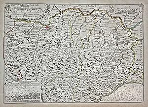
L'Etat du Duc de Parme contenant Les Duchés de Parme et Plaisance et les Etats Palavicin et de Landi &c." - Parma Piacenza Fidenza Cremona Italy Italia Karte map
Published by Paris c. 1702., 1702
Seller: Antiquariat Steffen Völkel GmbH, Seubersdorf, Germany
Seller Rating:
Map
Original altkolorierte Kupferstich-Karte von ca. 1702. - Blatt-Maße: ca. 54,5 x 38 cm. Platten-Maße: ca. 43 x 31 cm. -- gut erhalten. || Original old colored copper engraved map from c. 1702. -- in very good condition. || Dies ist ein Original! - Kein Nachdruck! - Keine Kopie! -- This is an original! No copy! - No reprint! Sprache: Französisch Gewicht in Gramm: 1550.
-
Le Duché de Mantoue dressé sur les memoires de F. Leandre Alberti de Castelli
Published by 1702, 1702
Seller: TABERNA LIBRARIA - ALAI - ILAB, Pistoia, Italy
Seller Rating:

Carta del ducato inc. in rame, confini col. all'epoca, mm.240x295 alla battuta + ampi marg. bianchi integri. Piegata centralmente all'origine. Perfetta.
-
Duché de Modene de Regio et de Carpi avec la Seigneurie de la Cafargnana
Published by 1702, 1702
Seller: TABERNA LIBRARIA - ALAI - ILAB, Pistoia, Italy
Seller Rating:
Carta del ducato con parte della lucchesia e Grafagnana inc. in rame, confini col. all'epoca, mm.240x290 alla battuta + marg. bianchi integri. Piegata centralmente all'origine. Non comune. Perfetta.
-
L'etat du Duc de Parme contenant les Duches de Parme et Plaisance et les Etats Palavicin.
Published by 1702, 1702
Seller: TABERNA LIBRARIA - ALAI - ILAB, Pistoia, Italy
Seller Rating:
Carta del ducato inc. in rame, confini col. all'epoca, mm.310x440 alla battuta + marg. bianchi integri. Piegata centralmente all'origine. Perfetta.
-

LE COMTÉ ET LEGATION DE BOULOGNE DIVISEÉ EN PLAINE DE BOULOGNE ET LA MONTAGNE
Publication Date: 1702
Map First Edition
Condition: ottimo. Incisione in rame. Carta tratta dal "Teatro della guerra in Italia" edito a Parigi nel 1705. Bella coloritura, ottimo stato di conservazione, di questa prima edizione. Formato: 395x300mm.
-
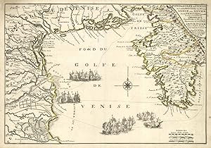
Fond du Golfe de Venise ou sont le bouches du Po et de l'Adige.
Published by Venezia - Istria
Seller: Sergio Trippini, Gavirate, Italy
Seller Rating:
Carta raffigurante il golfo di Venezia e parte del territorio costiero dalle bocche del fiume Po, nello Stato della Chiesa, e quello relativo alla Repubblica di Venezia compresa la penisola istriana. La coloritura confinle all'acquerello evidenzia la parte d'Istria di competenza austriaca come indicato nel titolo "l'empereur Tienta a Trieste et a Fiume des Magasins pour son Armeé d'Italie". Sempre nel titolo si legge la notizia che "le Roy d'Espagne a dans ce Golfe des Fregates pour empecher le transport". Proprio la presenza di queste navi porta agli scontri navali raffigurati sulla mappa. Piega centrale editoriale. Ottimo lo stato di conservazione generale.
-
L'Etat de Milan divise en ses principales partes: avec Partie des Etats de Venise et des Duches de Mantoue, de Parme et de Modene.
Published by Parigi, 1701
Seller: libreria antiquaria perini Sas di Perini, Verona, VR, Italy
Seller Rating:
Art / Print / Poster
Incisione in rame colorata d'epoca, di mm 475x590, in buono stato di conservazione, con alcuni piccoli restauri e tracce di umidit? marginali.
-
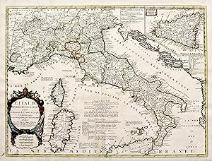
L'Italie divisČe en ses estats tirČe des Memoires du Sr. Cantel geographe et de plusieurs autres.corigČe et augmentČe par le Sr. Tillemont.
Published by Parigi, 1701
Seller: libreria antiquaria perini Sas di Perini, Verona, VR, Italy
Seller Rating:
Art / Print / Poster
Incisione in rame, colorata d'epoca ai confini, mm 455x610, in discreto stato di conservazione, con alcuni restauri a mende nella parte inferiore, una piccola mancanza al centro del margine inferiore, alcuni strappi restaurati Nr.cat: 1806.
-
Carte d'Europe divisee en ses Principeaux Etats suivant les Changements operes par differentes puissances dans ces derniers tems.
Published by Paris, Mondhare,, 1791
Book
Karton der Zeit. 1 Faltkarte (74 x 54 cm aufgeklappt) Vermerk auf Vorsatz, Karte min. randrissig u. fl. mit wenigen winzigen Löchern. Sprache: Französisch.
-
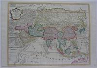
L'Asie Divisee en tous ses Etat
Published by Paris, 1746
Seller: Alexandre Antique Prints, Maps & Books, Toronto, ON, Canada
Seller Rating:

Map
Condition: Excellent. Size : 445x595 (mm), 17.5x23.375 (Inches), Hand Colored.
-
Plan Routier de la ville de paris et de ses faubourgs.
Published by Paris, 1699
Seller: Alexandre Antique Prints, Maps & Books, Toronto, ON, Canada
Seller Rating:
Map
Condition: Very Good. Size : 492x655 (mm), 19.37x25.79 (Inches), Hand Colored.
