Order Total (1 Item Items):
Shipping Destination:

Cary, John, Ca 1754 1835 (5 results)
Skip to main search results
Product Type
- All Product Types
- Books (3)
- Magazines & Periodicals
- Comics
- Sheet Music
- Art, Prints & Posters
- Photographs
- Maps (2)
-
Manuscripts &
Paper Collectibles
Condition
- All Conditions
- New
- Used
Binding
- All Bindings
- Hardcover (2)
- Softcover
Collectible Attributes
- First Edition
- Signed
- Dust Jacket
- Seller-Supplied Images
- Not Printed On Demand
Free Shipping
Seller Location
Seller Rating
-

Cary's New itinerary: or, An accurate delineation of the great roads : both direct and cross, throughout England and Wales; with many of the principal roads in Scotland. / From an actual measurement by John Cary ; made by command of his majesty's postmaster general, for official purposes ; under the direction and inspection of Thomas Hasker, Esqr., surveyor and superintendant of the mail coaches
Published by London : Printed for J. Cary, 1810
4th edition. Poor disbound copy; lacks boards. Spine worn. Pages tanned as with age. Text remains clear and without blemish. Physical description; [90] p., 866 columns, 868-936 p., [7] leaves of plates (5 folded). Subjects; Great Britain Guidebooks. Maps. 1 Kg.
-
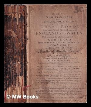
Cary's New itinerary: or, An accurate delineation of the great roads : both direct and cross, throughout England and Wales; with many of the principal roads in Scotland. / From an actual measurement by John Cary ; made by command of his majesty's postmaster general, for official purposes ; under the direction and inspection of Thomas Hasker, Esqr., surveyor and superintendant of the mail coaches
Published by London : Printed for J. Cary, 1810
4th edition. Poor disbound copy; lacks boards. Spine worn. Pages tanned as with age. Text remains clear and without blemish. Physical description; [90] p., 866 columns, 868-936 p., [7] leaves of plates (5 folded). Subjects; Great Britain Guidebooks. Maps. 1 Kg.
-
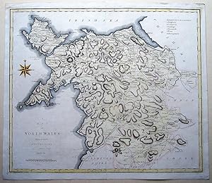
A Map of North Wales from the best Authorities.
Published by John Stockdale, 1806
Seller: Angelika C. J. Friebe Ltd. - MapWoman, Dorking, United Kingdom
Seller Rating:

Map
No Binding. Condition: Near Fine. copper engraved map with recent hand colouring, overall 43 x 49 cm, plate 41 x 47 cm. fold as issued; exc. cond.- An attractive map of North Wales, engraved by Cary for William Gough's enlarged version of William Camden's 'Britannia'.
-
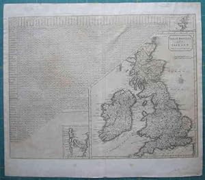
Great Britain and Ireland with ye Judges Circuits.
Published by John Stockdale, 1805
Seller: Angelika C. J. Friebe Ltd. - MapWoman, Dorking, United Kingdom
Seller Rating:
Map
No Binding. Condition: Very Good. engraved by John Cary, for: New British Atlas, publ. by John Stockdale, London, 1805.- copper engraved map; plate size 36,5 x 48,5 cm. paper evenly toned with some foxing; fold as issued; some paper thinness and 2 small holes; some marginal tears not aff. image; top margin remnants of paper hinges; some discolouration around image due to previous mount/frame; o/w vg cond.- This map shows 'The Distances of the Cities & Shire Towns in England and Wales' as an aide for judges, travelling the country's courthouses. With an inset of the Shetland Islands and the Hebrides; pagination in top right corner: to face Vol. I. p. CXLVIII.- John Cary (1755-1835) was an English map and globe maker, engraver and publisher. - [2454].
-
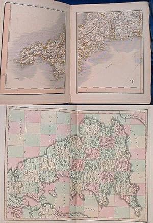
CARY'S NEW MAP OF ENGLAND AND WALES, with part of Scotland: On which are carefully laid down all the direct and principal cross roads, the course of the rivers and navigable canals, cities, market and borough towns, parishes, and most considerable hamlets, parks, forests &c. &c. delineated from actual surveys and materially assisted from authentic documents supplied by the Post Masters General.
Published by Cary 2nd edition corrected to 1832, London, 1832
Condition: Good. Hand-coloured maps on 81 leaves incl. General map, dedication, explanations, & distance gauge by Cary. Folio half calf (covers off & lacking spine/tips worn) 81 leaves + 102pp incl. adverts for Atlases. Slight edge dusting to a few leaves and some offsetting where opposite page is mainly sea. One opening has small ink spotting. All roads, boundaries and wooded areas coloured. 1 volume. Hardcover.