About this Item
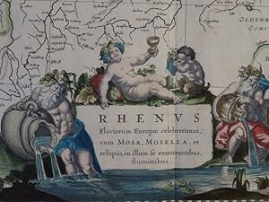
Große, gewestete Karte des Rheins von der Mündung bis zum Bodensee. Von zwei Platten gedruckt. Mit prächtiger allegorischer Titelkartusche, Dedikationskartusche sowie großer Wappenkartusche links oben mit 10 von Putten gehaltenen Wappen derjenigen Gebiete, durch die der Rhein fließt und einem Meilenzeiger.;$$;Rhine - Rhenus Fluviorum Europae Celeberrimus cum Mosa, Mosella, et reliquis in illum se exonerantibus, fluminibus. Old colored copper engraving map by Willem Blaeu. Amsterdam, 1635. 41.7 x 96.3 cm. Large, vestured map of the Rhine from the mouth to Lake Constance. Printed from two plates. With magnificent allegorical title cartouche, dedication cartouche and large coat of arms cartouche upper left with 10 coats of arms held by putti of the areas through which the Rhine flows and a mileage scale. Sprache: Deutsch Gewicht in Gramm: 500. Seller Inventory # 12046
Contact seller
Report this item
![]()
