About this Item
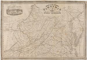
Lithographed map, 25 1/2 x 36 3/4 inches, with ornamental border and inset view of Richmond. Sheet trimmed to just outside the ornamental border and mounted on modern linen. Old folds now flattened. Small chip in upper right corner, just touching the ornamental border. Separations at a cross-folds with a few instances of small paper loss, stabilized by the linen backing. Good plus. This impressive Confederate map of Virginia was originally based on work done by Ludwig von Bucholtz in connection with his updating the famed Herman Boye map of Virginia in 1858. Bucholtz was hired to re-engrave the copperplates for maps of Virginia originally made by Herman Boye in 1826. The ultimate products of his work were the very large maps of Virginia called the Boye-Bucholtz maps. Using knowledge from his work on this project, Bucholtz issued his own map in 1858, lithographed and published by Ritchie & Dunnavant in Richmond. This map was vastly superior in detail and accuracy to Bucholtz's revision of the Boye map. In 1862, with Confederate officers in need of good maps of the region, Richmond publishers West & Johnson re-issued the Bucholtz-Ludwig 1858 map of Virginia, reprinted from the original stone with minor alterations (including the removal of the cartographer's name). "There are minor geographic changes from Map 1 [the original 1858 Bucholtz map] on Map 2 [the West & Johnson issue]. For example, on Map 2 Jerusalem in Southampton Co. has been moved a little to the northwest of its Map 1 location near the Seaboard and Roanoke Railroad, and the road between the two points imperfectly erased (the remaining shadow is additional evidence that the Map 1 stone was involved). Still, for the most part, Map 1 and Map 2 are the same map" - Wooldridge, "The Bucholtz- Ludwig Map of Virginia and its Successors" in THE PORTOLAN 68 (Spring, 2007), pp.26-39. A second edition of the West & Johnson issue would be published in 1864. The map shows all of Virginia, West Virginia, Maryland, Delaware, and parts of Pennsylvania and New Jersey, and includes an inset view of Capitol Square in Richmond. A chart below the view lists all the railroads and the length of each line. "In stark contrast to the large, often colored maps pouring out of Northern presses, the Confederate imprints are few in number, modest in scale, and more often than not black and white, printed on poor paper. Long before the war was over, they weren't being printed at all" - Wooldridge. PARRISH & WILLINGHAM 6204. SWEM 971. Wooldridge, "The Bucholtz-Ludwig Map of Virginia and its Successors" in THE PORTOLAN 68 (Spring, 2007), pp.26-39. STEPHENSON 475.5. WOOLDRIDGE 254. Seller Inventory # WRCAM46982A
Contact seller
Report this item
![]()

