About this Item
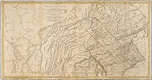
28 1/2 x 54 3/4 inches, outlined in period color, backed on canvas. Small ink stamp near title, a few small worm holes expertly repaired. Very good. With archival foam core board, protected with mylar sheet. A large and impressive map of the colony of Pennsylvania, published just a few months after the battle of Lexington and Concord, and drawing heavily from the landmark map executed by William Scull in 1770. Scull's original map is exceedingly rare, and noteworthy for showing the extensive Pennsylvania frontier, including western roads, paths, forts and other buildings, and the newly executed Mason-Dixon line. In the present map, printed for Sayer and Bennett, Scull's map is revised and improved, with clearer topographical delineations and including latitude and longitude markers. These improvements were likely added to aid British troops fighting in North America. Sayer and Bennett's map appears in several contemporary atlases, including Faden's THE NORTH AMERICAN ATLAS and Jefferys' THE AMERICAN ATLAS, both issued in 1776. Sayer and Bennett took over the Jefferys firm after Thomas Jefferys' death in 1771, and were among the most important British map publishers of their day. Not in Rumsey. PHILLIPS, MAPS, p.674. Hazel Shields Garrison, "Cartography of Pennsylvania Before 1800" in THE PENNSYLVANIA MAGAZINE OF HISTORY AND BIOGRAPHY, July 1935, pp.278-79. SCHWARTZ & EHRENBERG, p.170 (ref). Seller Inventory # WRCAM31014
Contact seller
Report this item
![]()
