About this Item
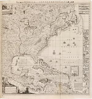
Engraved map by William Henry Toms on fifteen double-page and five single-page sheets, mounted on guards throughout, with the double- page key map by Toms, and the contents leaf tipped in as a fold-out from the rear free endpaper. Folio. Original half calf and marbled paper boards, raised bands. Boards with moderate wear and rubbing, loss to marbled paper in a few places, joints starting to separate but still strong, spine ends chipped. Bookplate and pencil notes on front pastedown (see below), light rumpling to endpapers. Minor worming at lower margin near gutter on the first few leaves (no text affected), one instance of slight staining, but overall very clean internally. Near fine. The Thomas W. Streeter copy of the first large-scale map of North America, and the first printed map to show the thirteen colonies, in original boards, complete with the separate key map and the contents leaf. Henry Popple produced this map under the auspices of the Lord Commissioners of Trade and Plantations to help settle disputes arising from the rival expansion of English, Spanish, and French colonies. "France claimed not only Canada, but also territories drained by the Mississippi and its tributaries - in practical terms, an area of half a continent" - Goss, p.122. The present copy of Popple's map would have been particularly useful in these early disputes. Benjamin Franklin, on May 22, 1746, ordered two copies of this map, "one bound the other in sheets," for the Pennsylvania Assembly. It was the only map of sufficient size and grandeur available - and the map is on a grand scale: if actually assembled it would result in a rectangle over eight feet square. Its coverage extends from the Grand Banks off Newfoundland to about ten degrees west of Lake Superior, and from the Great Lakes to the north coast of South America. Several of the sections are illustrated with handsome pictorial insets, including views of New York City, Niagara Falls, Mexico City, and Quebec, and inset maps of Boston, Charles-Town, Providence, Bermuda, and a number of others. "Little is known of Henry Popple except that he came from a family whose members had served the Board of Trade and Plantations for three generations, a connection that must have been a factor in his undertaking the map, his only known cartographic work" - McCorkle. Mark Babinski has made a detailed study of the issues and states of the Popple map. This copy is in Babinski's state 5: the imprint on sheet 20 reads, "London Engrav'd by Willm. Henry Toms 1733"; and sheet one includes the engraved figure "1" in the upper left corner just above the intersection of the two neat lines. The very rare small format table of contents is present. The key map is in Babinski's state 1, with only Toms' name below the border at the bottom and no additional place names in the seventeen small insets. Thomas W. Streeter's pencil notes on the front pastedown are significant with regard to the quality and provenance of this copy. He writes that "this fine copy in original binding and broad margins with the key map and leaf of contents attached to the final blank leaf [was acquired] from Roland Tree of Henry Stevens, Sept. 18, 1941. It was exchanged for a rebound copy lacking the key map and the leaf of contents and with narrow margins.I gave Stevens the former copy plus $75. The large key map is of considerable importance and I believe is somewhat rare as is the leaf of contents." Interestingly, Streeter's own notes on the provenance of this copy are at odds with the note in the catalogue of his sale, which states that he acquired this copy from Levinson in 1957. This copy sold at the Streeter sale to Sessler's in 1967 for $5250, acquired for H. Richard Dietrich Jr., and has remained in his Dietrich American Foundation since then. Mark Babinski, HENRY POPPLE'S 1733 MAP (New Jersey, 1998) (ref). BROWN, EARLY MAPS OF THE OHIO VALLEY 14. CUMMING, THE SOUTHEAST IN EARLY MAPS 216, 217 (refs). DEGREES OF LATITUDE 24, state 4 (b. Seller Inventory # WRCAM40340C
Contact seller
Report this item
![]()


