About this Item
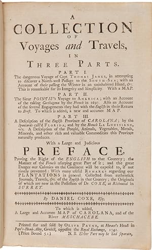
Three parts bound in one volume. [10],142; viii,86,[2]; [54],122pp. plus three folding maps. Contemporary calf boards, ruled in gilt, rebacked in matching calf, raised bands, gilt leather label. Moderate edge wear and rubbing, light scuffing to boards, corners worn. Short closed tear near stub of first map; two-inch closed tear and separations along folds on third map expertly mended on verso. Internally clean. Overall, very good. A rare collection of three works, which are sometimes found separately, but are here bound in a contemporary binding with the publisher's general titlepage (a note printed below the imprint on the general titlepage states: "N.B. Either Part may be had separate") and separate titlepages for the second and third works. The first part is a reissue of the 1740 edition of Thomas James' voyage, a classic of northwestern exploration which was first published in London in 1633. The second work is a reissue of the 1740 edition of Jean Bernard Louis Desjeans' AN AUTHENTICK AND PARTICULAR ACCOUNT OF THE TAKING OF CARTHAGENA (first published in English in London in 1698). The third part is the editor's own work, the 1741 fourth edition of A DESCRIPTION OF THE ENGLISH PROVINCE OF CAROLANA, after the original of 1722. Coxe's book is one of the first English works to extensively describe what would become the Southeastern United States. Coxe, who claimed grants to much of the South, sought to arouse British concern over French incursions, and did not limit himself to the Carolinas, discussing the lower Mississippi in detail as well. Florida, Georgia, and Louisiana are also described. Howes and Church assert that this fourth edition was augmented with additions, though the collation remains the same as that of the earlier editions. In fact, Lathrop Harper believed that the present work was made up of the sheets of the original 1722 edition, but with a new titlepage. The elder Daniel Coxe was physician to Charles II and Queen Anne. His son, who claimed to have resided in the Carolinas for some years, inherited his claims to grants and attempted to further them with this publication, which went through numerous later editions. Much of the information, gathered from British hunters and explorers, is published here for the first time. The work is also credited with being the first published proposal of a political confederation of the North American colonies. Cumming points out that the folding map accompanying the work is one of the very few maps that has "Carolana" printed on it, referring to the western territory adjacent to the colony of "Carolina." "This is a compilation from various journals to impress the English public with the great importance of the region described, and to make it jealous of its occupation by the French. Under the name of 'Carolana' was comprehended the present State of Georgia, the Floridas, Alabama, Mississippi, and Louisiana. The whole of this territory was claimed by Doctor Coxe, the father of the author, as proprietor under the Crown. The author explored a great part of it, and lived there for fourteen years. Coxe wished to colonize the banks of the Mississippi near its mouth, in spite of the French claim to the territory." - Church. "In the Preface is the first printed proposal for a political confederation of all the British North American Colonies, leading up to a Governor General to [be] appointed by the Crown" - Streeter. Although all of these works are encountered in the market separately and the three together as a collection are well documented by bibliographers, in our experience and that of other colleagues with long memories in Americana, this format as a collection of voyages is almost never seen; it is only the third set we have ever handled. Oddly, Howes rates the set of three works with his basic "a" rating but the separate issue of the third part as a "b." HOWES C825. SABIN 17278. EUROPEAN AMERICANA 741/47. VAIL 410. CLARK I, 68. CHURCH 886 (ref). STREETER 1120 (ref). LAT. Seller Inventory # WRCAM55406
Contact seller
Report this item
![]()


