About this Item
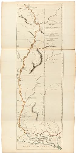
Letterpress title and index leaf, otherwise engraved throughout. Twenty-three engraved maps on thirty-one sheets (eighteen folding, eleven double-page), all handcolored in outline. Antique-style half speckled calf and marbled boards, spine with raised bands, bands and ornaments tooled in gilt, leather label. Titlepage somewhat soiled, early ownership inscription at top. Minor edge wear and edge soiling to some maps; a few minor instances of foxing. A few closed tears, not affecting images, neatly repaired. A handsome, near fine copy. THE AMERICAN ATLAS is the most important 18th-century atlas for America. Walter Ristow describes it as a "geographical description of the whole continent of America, as portrayed in the best available maps in the latter half of the eighteenth century.as a major cartographic reference work it was, very likely, consulted by American, English, and French civilian administrators and military officers during the Revolution." As a collection, THE AMERICAN ATLAS stands as the most comprehensive, detailed, and accurate survey of the American colonies at the beginning of the Revolution. Among the distinguished maps are Braddock Meade's "A Map of the Most Inhabited Parts of New England," the largest and most detailed map of New England that had yet been published; "The Provinces of New York and New Jersey" by Samuel Holland, the surveyor general for the northern American colonies; William Scull's "A Map of Pennsylvania," the first map of that colony to include its western frontier; Joshua Fry and Peter Jefferson's "A Map of the Most Inhabited part of Virginia," the best colonial map for the Chesapeake region; and Lieut. Ross' "Course of the Mississipi," the first map of that river based on English sources. Jefferys was the leading English cartographer of the 18th century. From about 1750 he published a series of maps of the English American colonies that were among the most significant produced in the period. As Geographer to the Prince of Wales, and after 1761, Geographer to the King, Jefferys was well placed to have access to the best surveys conducted in America, and many of his maps held the status of "official work." Jefferys died on November 20, 1771, and in 1775 his successors, Robert Sayer and John Bennett, gathered together these separately issued maps and republished them in book form as THE AMERICAN ATLAS. The only difference between this 1782 edition and the editions of 1776 and 1778 is the titlepage; the maps are all the same. They are as follows: 1) Braddock Meade (alias John Green): "A Chart of North and South America, including the Atlantic and Pacific Oceans." Published June 10, 1775. Six sheets joined into three, a total of 43½ x 49½ inches. This great wall map was chiefly issued to expose the errors in Delisle and Buache's map of the Pacific Northwest, published in Paris in 1752. 2) "Imperial Academy of St. Petersburg. The Russian Discoveries." Published March 2nd 1775. One sheet, 18 x 24 inches. 3) Thomas Pownall after E. Bowen: "A New and Correct Map of North America, with the West India Islands." Published July 15th 1779. Four sheets joined into two, 43 x 47 inches. Thomas Pownall updated Bowen's North America map of 1755. Pownall's version includes the results of the first Treaty of Paris drawn up after the end of the French and Indian War. 4) Thomas Jefferys: "North America from the French of Mr. D'Anville, Improved with the English Surveys Made since the Peace." Published June 10, 1775. One sheet, 18 x 20 inches. 5) Samuel Dunn: "A Map of the British Empire in North America." Published August 17, 1776. Half sheet, 12 x 19 inches. This updates Dunn's map of 1774. 6) Thomas Jefferys: "An Exact Chart of the River St. Laurence from Fort Frontenac to the Island of Anticosti." Published May 25, 1775. Two sheets joined into one, 23½ x 37 inches. 7) Sayer and Bennett: "A Chart of the Gulf of St. Laurence." Published March 25, 1775. One sheet, 19½ x 24 inches. 8) "A Map of the Island of St. Seller Inventory # WRCAM43278
Contact seller
Report this item
![]()


