Items related to Collins World Wall Paper Map
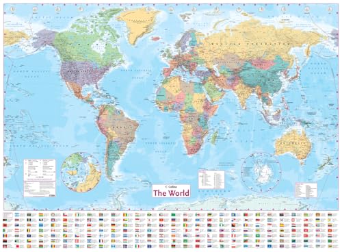

This Collins World Map has been fully updated to include the latest political changes. The map contains politically coloured mapping which shows each country and their capital city, major roads, railways and cities and towns clearly. Also included are national flags, key statistics for every country and inset maps of the polar regions.
The map is printed on high quality paper and is ideal for any classroom, bedroom or office wall.
INCLUDES:
� All recent political changes including the new independent country of South Sudan
� Changes to international dateline
AREA OF COVERAGE
All of the world, centred on the Greenwich Meridian, and including maps of the North and South Pole regions.
SCALE
1:22 000 000; 1 cm to 220 km; 1 inch to 347 miles
SIZE
1015 x 1380 mm (40 x 54 inches)
OTHER VERSIONS AVAILABLE
Laminated flat map in tube (ISBN 978-0-00-749310-4).
"synopsis" may belong to another edition of this title.
About the Author:
Explore the world through accurate and up-to-date mapping.
"About this title" may belong to another edition of this title.
- PublisherCollins
- Publication date2013
- ISBN 10 0007493118
- ISBN 13 9780007493111
- BindingPoster
- Number of pages1
(No Available Copies)
Search Books: Create a WantIf you know the book but cannot find it on AbeBooks, we can automatically search for it on your behalf as new inventory is added. If it is added to AbeBooks by one of our member booksellers, we will notify you!
Create a Want