Order Total (1 Item Items):
Shipping Destination:

california features (32 results)
Skip to main search results
Product Type
- All Product Types
- Books (31)
- Magazines & Periodicals
- Comics
- Sheet Music
- Art, Prints & Posters (1)
- Photographs
- Maps
-
Manuscripts &
Paper Collectibles
Condition
Binding
Collectible Attributes
- First Edition (5)
- Signed
- Dust Jacket (1)
- Seller-Supplied Images (22)
- Not Printed On Demand
Seller Location
Seller Rating
-

Shoot the Stars: How to Become a Celebrity Photographer (Paparazzi)
Published by Beverly Hills, California, U.S.A.: California Features, 1985
ISBN 10: 0933781008ISBN 13: 9780933781009
Book
Soft cover. Condition: Good. No Jacket. Shoot the Stars: How to Become a Celebrity Photographer, Elterman, Brad,Beverly Hills, California, U.S.A.: California Features, 1985, 158p, oversz. trade pb, covers bumped/scuffed, text unmarked/clean, binding solid--future paparazzi---6.00.
More buying choices from other sellers on AbeBooks
New offers from � 86.31
Used offers from � 4.95
Also find Softcover First Edition
-

Prowler Travel Trailer; 1976 - Your Passage to Adventure
Published by Feature Publicationletwood Enterprises Inc, California, 1976
Stapled Wrappers. Condition: VG+. Sales Literature for the 1976 ProwlerTravel Trailer. 8 pages, layout plans, feature chart. All color. Date in ink and dealer stamp to front. Ink notes on prices, weights etc to three pages. Weight, 25g. Lettermail may apply. Size: 11" by 8.5". Book.
-
Shoot the Stars - How to Become a Celebrity Photographer
Published by California Features International, Inc., Beverly Hills, 1985
First Edition
Condition: Very Good. Dust Jacket Condition: None. 158 pages. Softcover. Illustrated with black & white photographs. Bright, clean copy. Record # 612641.
-

Johnny Hazard: Volume Four (4), Danger A La Carte Daily Strips 10 Feb 47 to 15 Nov 47 - U.S. Classic Seires
Published by Kings Features Syndicate, California & Illinois, 1984
Paperback. Condition: Good. 48 pages. The cover has seperated from the book, but is in fine condition with a few minor scuffs and foxing. The page edges are lightly foxed and tanned. Books listed here are not stored at the shop. Please contact us if you want to pick up a book from Newtown.
-
Shoot the Stars: How to Become a Celebrity Photographer [2 volumes]
Published by California Features International, Los Angeles, CA, 1985
Seller: Lux Mentis, Booksellers, ABAA/ILAB, Portland, ME, U.S.A.
Seller Rating:

First Edition
Wraps. Condition: Very Good+. First Edition. First Edition. Wraps. From the Collection of Jenny Lens. One with portfolio of photocopied articles about Brad Elterman. Wrappers worn with some shelf-wear to the extremities present, else tight, bright, and unmarred. Glossy red and black paper wrappers. 8vo.158pp.illus. (b/w). Second volume with wrappers and photocopied articles.
-
Peanuts Lunch Bag Cook Book: Cartoons by Charles M. Schulz
Published by United Features Syndicate - Determined Productions, San Francisco, California, 1970
First Edition
Hard Cover. Condition: Fine. Dust Jacket Condition: Very Good. Schulz, Charles M. (illustrator). First Edition. The classic first edition. 1970 at copyright page; no additional printings. Unique 6" x 6" design. Red and beige pictorial boards, thick red borders w/bold black titles on all sides, light shelf wear. Cover depicts Charlie Brown seated on bench enjoying his brown bag sandwich. Thick heavy stock pages fine, no writing; interior continues w/the red bordered beige motif. Deep red endpapers. Bind fine; hinges intact. Scarce wrapper, light edge wear, rub, discoloration; protected in new clear sleeve. Extremely wide front and back flaps w/bold summary of this title. These are legitimate and simple, but tasty, recipes! Basic ingredients utilizing the traditional methods. Contents arranged alphabetical in sections: "Bread - white and wheat; Brown Bagger Hints; Cheese Balls; Desserts (a rather large selection); Deviled Eggs; Mayonaise; Potato Chips; Punch; Salads; Sandwiches (a rather large selection); and, Special Treats". Thirty-nine recipes in all w/an adjacent page of entertaining Peanuts strips. "Lunchtime! Lunchtime! Charlie Brown and Linus would be first to agree there's more to brown-bagging-it than jelly-bread sandwiches. If you're faced with making lunches day after day, for kids, or adults, rejoice and read on! June Dutton, fine cook, author of 'Peanuts Cook Book,' and mother of three, shares some of her best recipes. Charles M. Schulz packs in some delightful comments on primary eating habits and customs of his famed comic-strip gang of kids. To make your lunches look as good as they'll taste, brown bag them in Determined Productions Peanuts Lunch Bags." Not content with merely reprinting Schulz's previously published comics, Connie Boucher suggested an idea to Schulz. Why not create themed books featuring the beloved fictional gang of kids known as the "Peanuts". The square, colorful books were designed by her husband, Jim Young. Even the unflappable Schulz was amazed with the reception. Their first book, "Happiness Is a Warm Puppy" (1962), spent 45 weeks on the "New York Times" bestseller list. These classic "Peanuts" books were as engaging for adults as they were for children with their funny, hip aphorisims and the warm modernism of their design. 91 pages. Insured post. Size: 16mo - over 5�" - 6�" tall.
-
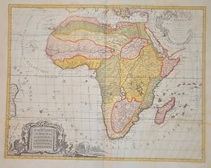
L'Afrique Divisee en ses Empires, Royaumes, et Etats Dressees
Published by Artist: Elwe Jan Barend ( - 1777 ) Amsterdam ; issued in: Amsterdam ; ca: 1792; - Jan Barend Elwe ( 177 - 1815) was a Dutch publisher and book seller who reissued maps by De L Isle and Ottens and some other cartographers in the late 18th century His famous map "Amerique Septentrionale Divisee en ses Principales Parties" was derived mainly from Sanson?s and Jaillot?s maps of 1656 and 1676 At this time California was no longer shown as an island but as a peninsular and the Great Lakes to the north are enclosed which was another feature often shown incorrectly on earlier maps of America This map has been published in 1792 in an Atlas which included 37 other maps of different countries, 1777
Seller: Antique Sommer& Sapunaru KG, M�nchen, Germany
Seller Rating:
Technic: Copper print; colorit: original colored; condition: top, left and right partly weak in print, size (in cm): 46 x 58,5 cm; - Map of the whole of Africa with splendid cartouche with inhabitants and animals of the continent. Upper title cartouche weak in print.
-
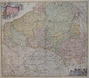
Carte nouvelle des Pais bas Catholiques
Published by Artist: Elwe Jan Barend ( - 1777 ) Amsterdam ; issued in: Amsterdam ; dated: 1792; - Jan Barend Elwe ( 177 - 1815) was a Dutch publisher and book seller who reissued maps by De L Isle and Ottens and some other cartographers in the late 18th century His famous map "Amerique Septentrionale Divisee en ses Principales Parties" was derived mainly from Sanson?s and Jaillot?s maps of 1656 and 1676 At this time California was no longer shown as an island but as a peninsular and the Great Lakes to the north are enclosed which was another feature often shown incorrectly on earlier maps of America This map has been published in 1792 in an Atlas which included 37 other maps of different countries, 1777
Seller: Antique Sommer& Sapunaru KG, M�nchen, Germany
Seller Rating:
Technic: Copper print; colorit: original colored; condition: Very good, size (in cm): 52 x 60; - Map shows total Belgium.
-
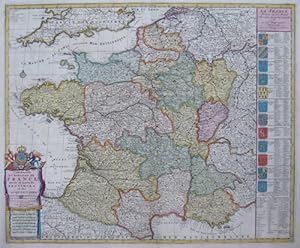
Carte nouvelle du Royaume de France divis� en toutes ses Provinces et ses acquisitions
Published by Artist: Elwe Jan Barend ( - 1777 ) Amsterdam ; issued in: Amsterdam ; dated: 1792; - Jan Barend Elwe ( 177 - 1815) was a Dutch publisher and book seller who reissued maps by De L Isle and Ottens and some other cartographers in the late 18th century His famous map "Amerique Septentrionale Divisee en ses Principales Parties" was derived mainly from Sanson?s and Jaillot?s maps of 1656 and 1676 At this time California was no longer shown as an island but as a peninsular and the Great Lakes to the north are enclosed which was another feature often shown incorrectly on earlier maps of America This map has been published in 1792 in an Atlas which included 37 other maps of different countries, 1777
Seller: Antique Sommer& Sapunaru KG, M�nchen, Germany
Seller Rating:
Technic: Copper print; colorit: original colored; condition: Very good, size (in cm): 48 x 58; - Map shows total France with the south part of England, also shows 12 beautiful coat of arms.
-
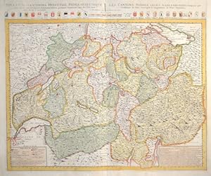
Nova et accuratissima Helvetiae, Foederaturumque. / Les Cantons Suisses, leurs Allies & Pays Sujets,.
Published by Artist: Elwe Jan Barend ( - 1777 ) Amsterdam ; issued in: Amsterdam ; dated: 1792; - Jan Barend Elwe ( 177 - 1815) was a Dutch publisher and book seller who reissued maps by De L Isle and Ottens and some other cartographers in the late 18th century His famous map "Amerique Septentrionale Divisee en ses Principales Parties" was derived mainly from Sanson?s and Jaillot?s maps of 1656 and 1676 At this time California was no longer shown as an island but as a peninsular and the Great Lakes to the north are enclosed which was another feature often shown incorrectly on earlier maps of America This map has been published in 1792 in an Atlas which included 37 other maps of different countries, 1777
Seller: Antique Sommer& Sapunaru KG, M�nchen, Germany
Seller Rating:
Technic: Copper print; colorit: original colored; condition: Perfect condition, size (in cm): 49,5 x 59,5; - Map depicts complete Swizzerland with all Kantons and their coat of arms.
-
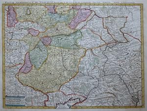
Partie meridionale de Moscovie, dress�e par G. de L Isle .
Published by Artist: Elwe Jan Barend ( - 1777 ) Amsterdam ; issued in: Amsterdam ; ca: 1792; - Jan Barend Elwe ( 177 - 1815) was a Dutch publisher and book seller who reissued maps by De L Isle and Ottens and some other cartographers in the late 18th century His famous map "Amerique Septentrionale Divisee en ses Principales Parties" was derived mainly from Sanson?s and Jaillot?s maps of 1656 and 1676 At this time California was no longer shown as an island but as a peninsular and the Great Lakes to the north are enclosed which was another feature often shown incorrectly on earlier maps of America This map has been published in 1792 in an Atlas which included 37 other maps of different countries, 1777
Seller: Antique Sommer& Sapunaru KG, M�nchen, Germany
Seller Rating:
Technic: Copper print; colorit: original colored; condition: Very good, size (in cm): 41,5 x 55; - Map shows the city of Moscow and its surrounding.
-
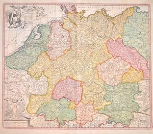
Germaniae Vulgo Duitschland,.
Published by Artist: Elwe Jan Barend ( - 1777 ) Amsterdam ; issued in: Amsterdam ; dated: 1792; - Jan Barend Elwe ( 177 - 1815) was a Dutch publisher and book seller who reissued maps by De L Isle and Ottens and some other cartographers in the late 18th century His famous map "Amerique Septentrionale Divisee en ses Principales Parties" was derived mainly from Sanson?s and Jaillot?s maps of 1656 and 1676 At this time California was no longer shown as an island but as a peninsular and the Great Lakes to the north are enclosed which was another feature often shown incorrectly on earlier maps of America This map has been published in 1792 in an Atlas which included 37 other maps of different countries, 1777
Seller: Antique Sommer& Sapunaru KG, M�nchen, Germany
Seller Rating:
Technic: Copper print; colorit: original colored; condition: Perfect condition, size (in cm): 49,5 x 58 cm; - Decorative map of Germany with Silesia, Bohemai, Netherlands, belgium, Elsass, Switzerland, Tyrol and Austria. With two cartouches, one with thegerman ; long necked double eagle;.
-
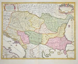
Le Royaume de Hongrie et les Estats qui ont est� Unis a sa Couronne
Published by Artist: Elwe Jan Barend ( - 1777 ) Amsterdam ; issued in: Amsterdam ; dated: 1792; - Jan Barend Elwe ( 177 - 1815) was a Dutch publisher and book seller who reissued maps by De L Isle and Ottens and some other cartographers in the late 18th century His famous map "Amerique Septentrionale Divisee en ses Principales Parties" was derived mainly from Sanson?s and Jaillot?s maps of 1656 and 1676 At this time California was no longer shown as an island but as a peninsular and the Great Lakes to the north are enclosed which was another feature often shown incorrectly on earlier maps of America This map has been published in 1792 in an Atlas which included 37 other maps of different countries, 1777
Seller: Antique Sommer& Sapunaru KG, M�nchen, Germany
Seller Rating:
Technic: Copper print; colorit: original colored; condition: Very good, size (in cm): 42,5 x 55; - Map shows total Dalmatia, Hungary, Moldavia, Romania, Bosnia, Serbia, partly Croatia, Turkey and two beautiful cartouches.
-
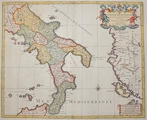
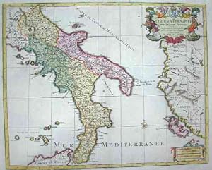
Le Royaume de Naples divis� en douze provinces.
Published by Artist: Elwe Jan Barend ( - 1777 ) Amsterdam ; issued in: Amsterdam ; dated: 1792; - Jan Barend Elwe ( 177 - 1815) was a Dutch publisher and book seller who reissued maps by De L Isle and Ottens and some other cartographers in the late 18th century His famous map "Amerique Septentrionale Divisee en ses Principales Parties" was derived mainly from Sanson?s and Jaillot?s maps of 1656 and 1676 At this time California was no longer shown as an island but as a peninsular and the Great Lakes to the north are enclosed which was another feature often shown incorrectly on earlier maps of America This map has been published in 1792 in an Atlas which included 37 other maps of different countries, 1777
Seller: Antique Sommer& Sapunaru KG, M�nchen, Germany
Seller Rating:
Technic: Copper print; colorit: original colored; condition: Very good, size (in cm): 43,5 x 53,5; - Map shows south Italy with its 12 provinces and partly Sicily and Greece with the island Corfu.
-
Carte de l Egypte de la Nubie de l Abissine
Published by Artist: Elwe Jan Barend ( - 1777 ) Amsterdam ; issued in: Amsterdam ; dated: 1792; - Jan Barend Elwe ( 177 - 1815) was a Dutch publisher and book seller who reissued maps by De L Isle and Ottens and some other cartographers in the late 18th century His famous map "Amerique Septentrionale Divisee en ses Principales Parties" was derived mainly from Sanson?s and Jaillot?s maps of 1656 and 1676 At this time California was no longer shown as an island but as a peninsular and the Great Lakes to the north are enclosed which was another feature often shown incorrectly on earlier maps of America This map has been published in 1792 in an Atlas which included 37 other maps of different countries, 1777
Seller: Antique Sommer& Sapunaru KG, M�nchen, Germany
Seller Rating:
Technic: Copper print; colorit: original colored; condition: Very good, size (in cm): 48,50 x 56,50; - Map shows Egypt, Nubia, Ethiopia and Arabia.
-
Le royaume de Naples divise en douze provinces
Published by Artist: Elwe Jan Barend ( - 1777 ) Amsterdam ; issued in: Amsterdam ; dated: 1792; - Jan Barend Elwe ( 177 - 1815) was a Dutch publisher and book seller who reissued maps by De L Isle and Ottens and some other cartographers in the late 18th century His famous map "Amerique Septentrionale Divisee en ses Principales Parties" was derived mainly from Sanson?s and Jaillot?s maps of 1656 and 1676 At this time California was no longer shown as an island but as a peninsular and the Great Lakes to the north are enclosed which was another feature often shown incorrectly on earlier maps of America This map has been published in 1792 in an Atlas which included 37 other maps of different countries, 1777
Seller: Antique Sommer& Sapunaru KG, M�nchen, Germany
Seller Rating:
Technic: Copper print; colorit: original colored; condition: Very good, size (in cm): 43,5 x 54; - Map shows south Italy with the Abruzzia, Campania, Apulia, Basilicata and Calabria, Corfu and the Leparic islands.
-
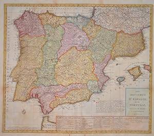
Les Royaumes d'Espagne et de Portugal
Published by Artist: Elwe Jan Barend ( - 1777 ) Amsterdam ; issued in: Amsterdam ; ca: 1792; - Jan Barend Elwe ( 177 - 1815) was a Dutch publisher and book seller who reissued maps by De L Isle and Ottens and some other cartographers in the late 18th century His famous map "Amerique Septentrionale Divisee en ses Principales Parties" was derived mainly from Sanson?s and Jaillot?s maps of 1656 and 1676 At this time California was no longer shown as an island but as a peninsular and the Great Lakes to the north are enclosed which was another feature often shown incorrectly on earlier maps of America This map has been published in 1792 in an Atlas which included 37 other maps of different countries, 1777
Seller: Antique Sommer& Sapunaru KG, M�nchen, Germany
Seller Rating:
Technic: Copper print; colorit: original colored; condition: Very good, size (in cm): 50 x 58 cm; - Map shows total Spain with Portugal and the Balearic island of Mallorca, Menorca and Ibiza with a decorative title cartouche. On the lower right pannel a description of the counties.
-
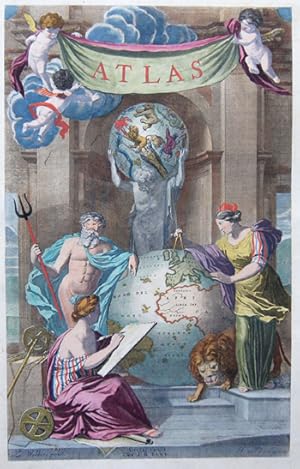
Atlas
Published by Artist: Elwe Jan Barend ( - 1777 ) Amsterdam ; issued in: Amsterdam ; ca: 1792; - Jan Barend Elwe ( 177 - 1815) was a Dutch publisher and book seller who reissued maps by De L Isle and Ottens and some other cartographers in the late 18th century His famous map "Amerique Septentrionale Divisee en ses Principales Parties" was derived mainly from Sanson?s and Jaillot?s maps of 1656 and 1676 At this time California was no longer shown as an island but as a peninsular and the Great Lakes to the north are enclosed which was another feature often shown incorrectly on earlier maps of America This map has been published in 1792 in an Atlas which included 37 other maps of different countries, 1777
Seller: Antique Sommer& Sapunaru KG, M�nchen, Germany
Seller Rating:
Art / Print / Poster
Technic: Copper print; colorit: original colored; condition: Very good, size (in cm): 45,5 x 28,5; - Titlepage from the world Atlas of J.B. Elwe issued in Amsterdam 1792.
-
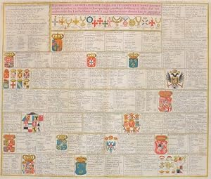
Historische en Geographische, Tafel. Om te leren een kort begrip vande Landen en Staaten in Europa. Haar grootheyt Besitting en alles at tot.
Published by Artist: Elwe Jan Barend ( - 1777 ) Amsterdam ; issued in: Amsterdam ; dated: 1792; - Jan Barend Elwe ( 177 - 1815) was a Dutch publisher and book seller who reissued maps by De L Isle and Ottens and some other cartographers in the late 18th century His famous map "Amerique Septentrionale Divisee en ses Principales Parties" was derived mainly from Sanson?s and Jaillot?s maps of 1656 and 1676 At this time California was no longer shown as an island but as a peninsular and the Great Lakes to the north are enclosed which was another feature often shown incorrectly on earlier maps of America This map has been published in 1792 in an Atlas which included 37 other maps of different countries, 1777
Seller: Antique Sommer& Sapunaru KG, M�nchen, Germany
Seller Rating:
Technic: Copper print; colorit: original colored; condition: Perfect condition, size (in cm): 49 x 57; - Map depicts the coat of arms of countries, kingdoms and citie of Europe. Very decorative with description of all the important emperors of the time.
-
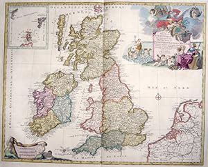
Les Isles Britanniques qui contiennent les Royaumes d Angleterre, Escosse, et Irlande.
Published by Artist: Elwe Jan Barend ( - 1777 ) Amsterdam ; issued in: Amsterdam ; dated: 1792; - Jan Barend Elwe ( 177 - 1815) was a Dutch publisher and book seller who reissued maps by De L Isle and Ottens and some other cartographers in the late 18th century His famous map "Amerique Septentrionale Divisee en ses Principales Parties" was derived mainly from Sanson?s and Jaillot?s maps of 1656 and 1676 At this time California was no longer shown as an island but as a peninsular and the Great Lakes to the north are enclosed which was another feature often shown incorrectly on earlier maps of America This map has been published in 1792 in an Atlas which included 37 other maps of different countries, 1777
Seller: Antique Sommer& Sapunaru KG, M�nchen, Germany
Seller Rating:
Technic: Copper print; colorit: original colored; condition: Very good, size (in cm): 47 x 59; - Map shows total Great Britain, inset map shows Orkney and Shettland Islands,; - Special feature: Map with 2 beautiful cartouches.
-
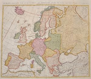
Europe, compos�e par G. d Isle et corrig�e selon le plus nouvelle observations
Published by Artist: Elwe Jan Barend ( - 1777 ) Amsterdam ; issued in: Amsterdam ; dated: 1792; - Jan Barend Elwe ( 177 - 1815) was a Dutch publisher and book seller who reissued maps by De L Isle and Ottens and some other cartographers in the late 18th century His famous map "Amerique Septentrionale Divisee en ses Principales Parties" was derived mainly from Sanson?s and Jaillot?s maps of 1656 and 1676 At this time California was no longer shown as an island but as a peninsular and the Great Lakes to the north are enclosed which was another feature often shown incorrectly on earlier maps of America This map has been published in 1792 in an Atlas which included 37 other maps of different countries, 1777
Seller: Antique Sommer& Sapunaru KG, M�nchen, Germany
Seller Rating:
Technic: Copper print; colorit: original colored; condition: Very good, size (in cm): 50 x 58,5; - Map shows total Europe with Island.
-
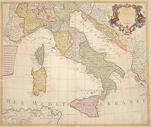
L Italie dress�e sur les Observations.
Published by Artist: Elwe Jan Barend ( - 1777 ) Amsterdam ; issued in: Amsterdam ; dated: 1792; - Jan Barend Elwe ( 177 - 1815) was a Dutch publisher and book seller who reissued maps by De L Isle and Ottens and some other cartographers in the late 18th century His famous map "Amerique Septentrionale Divisee en ses Principales Parties" was derived mainly from Sanson?s and Jaillot?s maps of 1656 and 1676 At this time California was no longer shown as an island but as a peninsular and the Great Lakes to the north are enclosed which was another feature often shown incorrectly on earlier maps of America This map has been published in 1792 in an Atlas which included 37 other maps of different countries, 1777
Seller: Antique Sommer& Sapunaru KG, M�nchen, Germany
Seller Rating:
Technic: Copper print; colorit: original colored; condition: Perfect condition, size (in cm): 46 x 54,5 cm; - Map shows the whole of Italy with Corsica, Sardinia, Sicily, partly Croatia, Dalmatia and a title cartouche.
-

Nouvelle Carte de la petite Tartarie ou Turie , montrant les fronti�res de l imperatrice de Russie.
Published by Artist: Elwe Jan Barend ( - 1777 ) Amsterdam ; issued in: Amsterdam ; dated: 1792; - Jan Barend Elwe ( 177 - 1815) was a Dutch publisher and book seller who reissued maps by De L Isle and Ottens and some other cartographers in the late 18th century His famous map "Amerique Septentrionale Divisee en ses Principales Parties" was derived mainly from Sanson?s and Jaillot?s maps of 1656 and 1676 At this time California was no longer shown as an island but as a peninsular and the Great Lakes to the north are enclosed which was another feature often shown incorrectly on earlier maps of America This map has been published in 1792 in an Atlas which included 37 other maps of different countries, 1777
Seller: Antique Sommer& Sapunaru KG, M�nchen, Germany
Seller Rating:
Technic: Copper print; colorit: original colored; condition: Double fold due to the printing, size (in cm): 51 x 59; - Map shows the peninsula Krim, Ukraine and the Black Sea with contiguous regions.
-
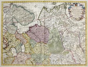
Carte Nouvelle de Moscovie Represente la partie Septentrionale.
Published by Artist: Elwe Jan Barend ( - 1777 ) Amsterdam ; dated: 1792; - Jan Barend Elwe ( 177 - 1815) was a Dutch publisher and book seller who reissued maps by De L Isle and Ottens and some other cartographers in the late 18th century His famous map "Amerique Septentrionale Divisee en ses Principales Parties" was derived mainly from Sanson?s and Jaillot?s maps of 1656 and 1676 At this time California was no longer shown as an island but as a peninsular and the Great Lakes to the north are enclosed which was another feature often shown incorrectly on earlier maps of America This map has been published in 1792 in an Atlas which included 37 other maps of different countries, 1777
Seller: Antique Sommer& Sapunaru KG, M�nchen, Germany
Seller Rating:
Technic: Copper print; colorit: original colored; condition: Very good, size (in cm): 41 x 54; - Map shows the northern part of european Russia with the distric Karelia and the peninsula Kola, Archangelsk, Jarensk to Wologia.
-
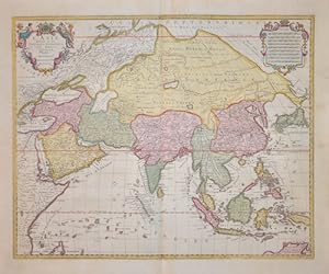
L' Asie
Published by Artist: Elwe Jan Barend ( - 1777 ) Amsterdam ; issued in: Amsterdam ; dated: 1792; - Jan Barend Elwe ( 177 - 1815) was a Dutch publisher and book seller who reissued maps by De L Isle and Ottens and some other cartographers in the late 18th century His famous map "Amerique Septentrionale Divisee en ses Principales Parties" was derived mainly from Sanson?s and Jaillot?s maps of 1656 and 1676 At this time California was no longer shown as an island but as a peninsular and the Great Lakes to the north are enclosed which was another feature often shown incorrectly on earlier maps of America This map has been published in 1792 in an Atlas which included 37 other maps of different countries, 1777
Seller: Antique Sommer& Sapunaru KG, M�nchen, Germany
Seller Rating:
Technic: Copper print; colorit: original colored; condition: Perfect condition, size (in cm): 46,5 x 58 cm; - Map shows total Asia, Southeast Asia, a magnificent title cartouche and a mileage indicator cartouche.