
Order Total (1 Item Items):
Shipping Destination:

Mehmed Abdulkadir Beyin Osman Makram (1 results)
Skip to main search results
Product Type
- All Product Types
- Books
- Magazines & Periodicals
- Comics
- Sheet Music
- Art, Prints & Posters
- Photographs
- Maps (1)
-
Manuscripts &
Paper Collectibles
Condition
- All Conditions
- New
- Used
Binding
- All Bindings
- Hardcover
- Softcover
Collectible Attributes
- First Edition
- Signed
- Dust Jacket
- Seller-Supplied Images
- Not Printed On Demand
Seller Location
Seller Rating
-
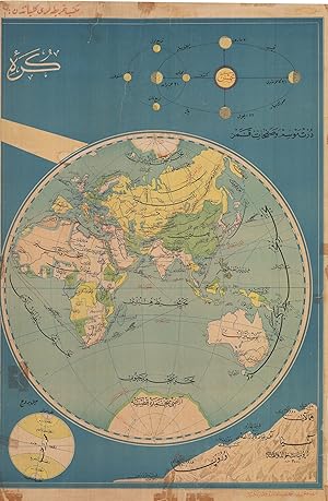
OTTOMAN CARTOGRAPHY / EASTERN HEMISPHERE
Published by Istanbul: Mektep Haritalari K�lliyatindan / Printing Office of Documentary maps [circa ], 1910
Seller: Antiquariat Dasa Pahor GbR, M�nchen, Germany
Seller Rating:

Map
Colour lithography, 96 x 63 cm (37.9 x 24.8 inches), (minor staining, tears repaired with modern tape and partly age-toned). A large map in Ottoman language represents the Eastern Hemisphere in the time around 1910. Marked are the major sea and train routes. The highest and most famous mountains of Asia, Africa and Europe, being Himalaya. Kilimanjaro, Mont Blanc and Vesuvius, are showcased in the lower right corner. They are compared to the elevation of the East European Plain (here marked as Russian Plain). The map was drafted by an Ottoman cartographer Mehmed Abdulkadir Beyin, who was known for his large scale maps, mostly printed in colour and published by Mektep Haritalari K�lliyatindan (Printing office of documentary maps) for educational purposes.