Order Total (1 Item Items):
Shipping Destination:

Walling, H F (229 results)
Skip to main search results
Product Type
- All Product Types
- Books (226)
- Magazines & Periodicals
- Comics
- Sheet Music
- Art, Prints & Posters
- Photographs
- Maps (3)
-
Manuscripts &
Paper Collectibles
Condition
Binding
Collectible Attributes
- First Edition (6)
- Signed
- Dust Jacket
- Seller-Supplied Images (190)
- Not Printed On Demand (220)
Free Shipping
Seller Location
Seller Rating
-
PAP. Condition: New. New Book. Shipped from UK. Established seller since 2000.
More buying choices from other sellers on AbeBooks
New offers from � 16.17
-

HRD. Condition: New. New Book. Shipped from UK. Established seller since 2000.
More buying choices from other sellers on AbeBooks
New offers from � 27.39
-
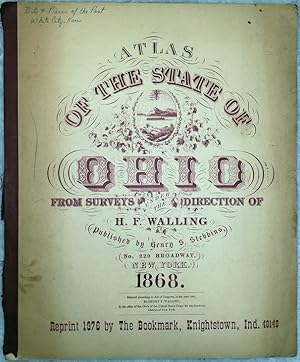
Soft cover. Condition: Fair. Dust Jacket Condition: No Dust Jacket. Reprint. Facsimile reprint of the original 1868 first edition. There are a few inked ownership marks on the front cover and title page, as well as an old inked price. The binder's tape spine cover is a little worn, and there is light other general wear. Volume remains tight, and is otherwise generally clean. Good working copy.
-
![Stock image for Tackabury's Atlas of the Dominion of Canada [microform] for sale by Ria Christie Collections](https://pictures.abebooks.com/isbn/9781015043831-uk-300.jpg)
Tackabury's Atlas of the Dominion of Canada [microform]
Published by Legare Street Press, 2021
ISBN 10: 1015043836ISBN 13: 9781015043831
Book Print on Demand
Condition: New. PRINT ON DEMAND Book; New; Fast Shipping from the UK. No. book.
More buying choices from other sellers on AbeBooks
New offers from � 23.63
-
![Stock image for Atlas of the Dominion of Canada [microform] for sale by Ria Christie Collections](https://pictures.abebooks.com/isbn/9781013860515-uk-300.jpg)
Atlas of the Dominion of Canada [microform]
Published by Legare Street Press, 2021
ISBN 10: 1013860519ISBN 13: 9781013860515
Book Print on Demand
Condition: New. PRINT ON DEMAND Book; New; Fast Shipping from the UK. No. book.
More buying choices from other sellers on AbeBooks
New offers from � 23.63
-

Oversized paperback. Reprint. 146 pgs. 1977 reproduction to scale of 1872 atlas. Very good softcover. Top edge of spine nicked. No international shipping due to size.
-
![Stock image for Atlas of the Dominion of Canada [microform] for sale by Ria Christie Collections](https://pictures.abebooks.com/isbn/9781013381072-uk-300.jpg)
Atlas of the Dominion of Canada [microform]
Published by Legare Street Press, 2021
ISBN 10: 1013381076ISBN 13: 9781013381072
Book Print on Demand
Condition: New. PRINT ON DEMAND Book; New; Fast Shipping from the UK. No. book.
More buying choices from other sellers on AbeBooks
New offers from � 30.91
-
![Stock image for Tackabury's Atlas of the Dominion of Canada [microform] for sale by Ria Christie Collections](https://pictures.abebooks.com/isbn/9781013811777-uk-300.jpg)
Tackabury's Atlas of the Dominion of Canada [microform]
Published by Legare Street Press, 2021
ISBN 10: 1013811771ISBN 13: 9781013811777
Book Print on Demand
Condition: New. PRINT ON DEMAND Book; New; Fast Shipping from the UK. No. book.
More buying choices from other sellers on AbeBooks
New offers from � 30.91
-
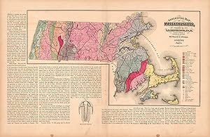
This hand colored map is from Walling and Grays Official Topographical Atlas of Massachusetts from Astronomical, Trigonometrical, and Various Local Surveys published in 1871. This map shows the geological features of Massachusetts- the mineral and the lithological group it is from are identified by color from a key on the map. Surrounding the map is text explaining the research on the states geological features and the information illustrated in the map. This map measures 14.75 inches by 24 inches.
-
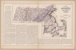
Climatological Map of Massachusetts Showing the Average Temperature and Amount of Rainfall
Publication Date: 1871
This hand colored map is from Walling and Grays Official Topographical Atlas of Massachusetts from Astronomical, Trigonometrical, and Various Local Surveys published in 1871. This climatological map illustrates the average temperature and rain fall in Massachusetts for the Summer, Winter and year in full. Details include counties, important cities and rail lines. The surrounding text describes the climate and expands on the information provided in the map. This map measures 14.5 inches by 23.5 inches.
-
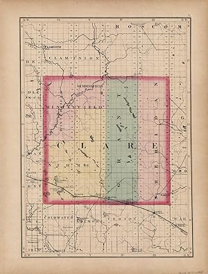
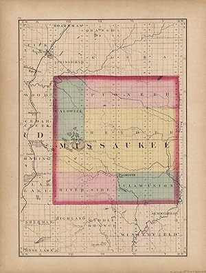
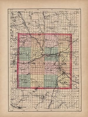
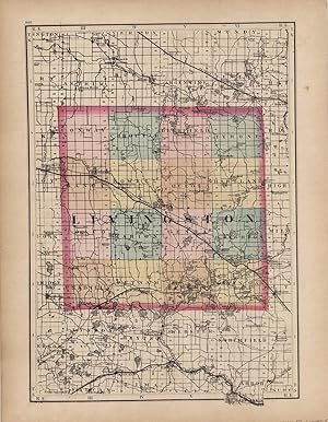
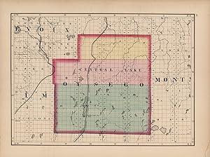
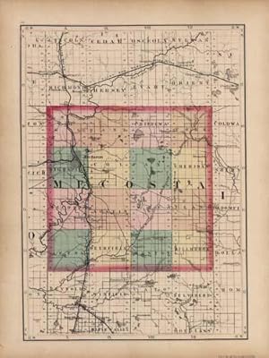
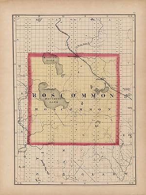
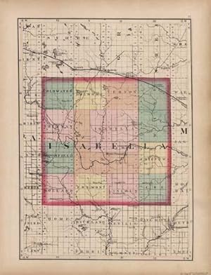
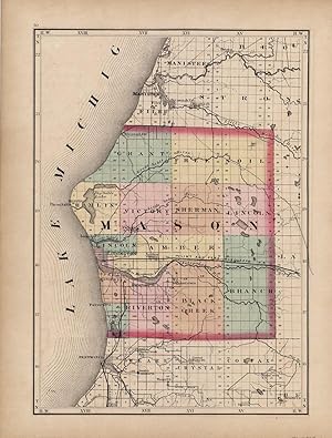
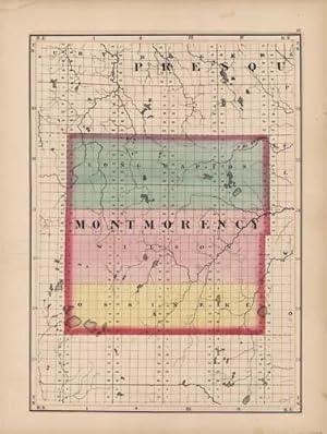
This beautiful map was originally published in "Tackaburys Atlas of the State of Michigan" in 1873. This map was published by George N. Tackabury, Detroit, Michigan. Tackabury was one of the U.S.s finest state and county map publishers. The maps within were drawn and compiled by Henry F. Walling. Each map has original hand coloring in beige, yellow, pink and green. The fine detail of this map shows cities, towns, rivers, lakes, post offices, roads, and most important, the existing railroad network. All railroads are labeled. This map measures 15 inches by 11 inches.
-

This hand colored map is from Walling and Grays Official Topographical Atlas of Massachusetts from Astronomical, Trigonometrical, and Various Local Surveys," published in 1871. This map of Worcester County is colored in vibrant pastels. Details include rail lines, county names, the names of important cities, major roads, lakes and rivers. This map measures 23 inches by 17 inches.
-
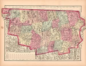
This hand colored map is from Walling and Grays Official Topographical Atlas of Massachusetts from Astronomical, Trigonometrical, and Various Local Surveys published in 1871. This bright pastel map is of Franklin County. Details include rail lines, the names of important cities, major roads, lakes and rivers.Important land owners and businesses are also identified. This map measures 10.5 inches by 17 inches.
-
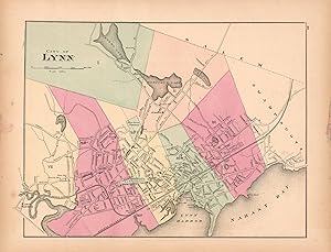
This hand colored map is from Walling and Grays Official Topographical Atlas of Massachusetts from Astronomical, Trigonometrical, and Various Local Surveys published in 1871. This bright pastel map of the City of Lynn and its surrounding areas illustrates the street plan of the area. Details include rail lines, the names of neighborhoods, rail lines, lakes and rivers as well as important buildings. This map measures 11 inches by 14.5 inches.
-
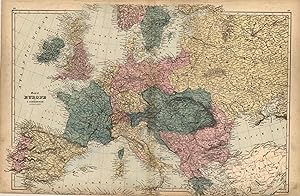
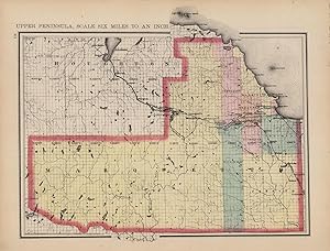
H. F. Walling made the maps in "Tackaburys Atlas of the Dominion of Canada" in 1875. These detailed county maps show the names of counties and cities, rivers and lakes. Europe is illustrated on this beautiful, hand colored double page map. The bottom of the map continues through the margins to the edge of the page. This map measures 25.25 inches by 50 inches.
-
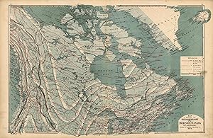
H. F. Walling made the maps in "Tackaburys Atlas of the Dominion of Canada" in 1875. This map shows the climatological features of the Dominion of Canada. A key describes the features used to identify seasonal temperatures and rainfall (partially obscured by the remains of a label that was placed on top of the key). This map measures 26 inches by 50 inches.
-
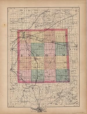
This beautiful map was originally published in "Tackaburys Atlas of the State of Michigan" in 1873. This map was published by George N. Tackabury, Detroit, Michigan. Tackabury was one of the U.S.s finest state and county map publishers. The maps within were drawn and compiled by Henry F. Walling. Each map has original hand coloring in beige, yellow, pink and green. The fine detail of this map shows cities, towns, rivers, lakes, post offices, roads, and most important, the existing railroad network. All railroads are labeled. This map measures 15 inches by 11 inches.
-
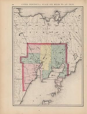
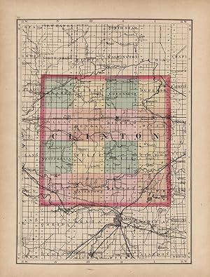
This beautiful map was originally published in "Tackaburys Atlas of the State of Michigan" in 1873. This map was published by George N. Tackabury, Detroit, Michigan. Tackabury was one of the U.S.s finest state and county map publishers. The maps within were drawn and compiled by Henry F. Walling. Each map has original hand coloring in beige, yellow, pink and green. The fine detail of this map shows cities, towns, rivers, lakes, post offices, roads, and most important, the existing railroad network. All railroads are labeled. This map measures 11 inches by 15 inches.
-
This beautiful map was originally published in "Tackaburys Atlas of the State of Michigan" in 1873. This map was published by George N. Tackabury, Detroit, Michigan. Tackabury was one of the U.S.s finest state and county map publishers. The maps within were drawn and compiled by Henry F. Walling. Each map has original hand coloring in beige, yellow, pink and green. The fine detail of this map shows cities, towns, rivers, lakes, post offices, roads, and most important, the existing railroad network. All railroads are labeled. This map measures 15 inches by 11 inches.
-
This beautiful map was originally published in "Tackaburys Atlas of the State of Michigan" in 1873. This map was published by George N. Tackabury, Detroit, Michigan. Tackabury was one of the U.S.s finest state and county map publishers. The maps within were drawn and compiled by Henry F. Walling. Each map has original hand coloring in beige, yellow, pink and green. The fine detail of this map shows cities, towns, rivers, lakes, post offices, roads, and most important, the existing railroad network. All railroads are labeled. This map measures 15 inches by 12 inches.
-
This beautiful map was originally published in "Tackaburys Atlas of the State of Michigan" in 1873. This map was published by George N. Tackabury, Detroit, Michigan. Tackabury was one of the U.S.s finest state and county map publishers. The maps within were drawn and compiled by Henry F. Walling. Each map has original hand coloring in beige, yellow, pink and green. The fine detail of this map shows cities, towns, rivers, lakes, post offices, roads, and most important, the existing railroad network. All railroads are labeled. This map measures 15 inches by 11 inches.
-
This beautiful map was originally published in "Tackaburys Atlas of the State of Michigan" in 1873. This map was published by George N. Tackabury, Detroit, Michigan. Tackabury was one of the U.S.s finest state and county map publishers. The maps within were drawn and compiled by Henry F. Walling. Each map has original hand coloring in beige, yellow, pink and green. The fine detail of this map shows cities, towns, rivers, lakes, post offices, roads, and most important, the existing railroad network. All railroads are labeled. This map measures 11 inches by 15 inches.
-
This beautiful map was originally published in "Tackaburys Atlas of the State of Michigan" in 1873. This map was published by George N. Tackabury, Detroit, Michigan. Tackabury was one of the U.S.s finest state and county map publishers. The maps within were drawn and compiled by Henry F. Walling. Each map has original hand coloring in beige, yellow, pink and green. The fine detail of this map shows cities, towns, rivers, lakes, post offices, roads, and most important, the existing railroad network. All railroads are labeled. This map measures 15 inches by 11 inches.