Order Total (1 Item Items):
Shipping Destination:

Seutter, M (31 results)
Skip to main search results
Product Type
- All Product Types
- Books (7)
- Magazines & Periodicals
- Comics
- Sheet Music
- Art, Prints & Posters (6)
- Photographs
- Maps (18)
-
Manuscripts &
Paper Collectibles
Condition
- All Conditions
- New
- Used
Binding
- All Bindings
- Hardcover (1)
- Softcover
Collectible Attributes
- First Edition
- Signed (1)
- Dust Jacket
- Seller-Supplied Images (25)
- Not Printed On Demand
Seller Location
Seller Rating
-
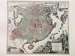
Reproduction-Opulentissimum Sinarum Imperium (by M. Seutter, 1740)
Publication Date: 2015
Map
No Binding. Condition: As New. 1740 (2015)62.5 x 52.5 cm. A striking and highly detailed map of China, coloured by provinces. It extends to Korea (shown as a peninsula) and most of Japan. Title with beautifully detailed decorative cartouche representing Chinese, European traders, Jesuit priests and classical European gods. An allegorical figure of 'Europa' sitting on a treasure chest points to a European fleet. The Great Wall of China is visible.
-
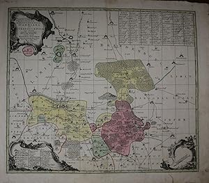
Praefecturae Pricipatus Querfurtensis Dahmiana et L�terboccensis cum vicinia oppidis, vicis, pagis accurate distincta, vaenit apud Matthaeum Seutterum Geogr. Caesar. Aug. Vind. Altkolorierte Kupferstichkarte.
Published by Augsburg, Seutter o.J. (ca. 1740)., 1740
Map
Condition: Gut. 50 x 58 cm. Mit 3 Kartuschen und einem Ortsregister in den 4 Ecken. *Zeigt die �mter Dahme, J�terbog, Brandenburg und Baruth. - Kleiner hinterlegter Randeinriss (im unteren Blattrand), insgesamt gut erhalten. Sprache: Deutsch Gewicht in Gramm: 1200.
-
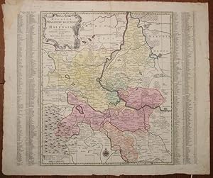
Ducatus Magdeburgensis et Halensis cum finitimis Delineatio geographica, curante Matthaeo Seuttero Geographo Caesar. Aug. Vindel. Cum Priv. S. Reg. Polon et Elect. Saxon. Altkolorierte Kupferstichkarte.
Published by Augsburg, Seutter o.J. (ca. 1750)., 1750
Map
Titelkartusche links oben. Condition: Gut. 50 x 58,5 cm. Links und rechts neben der Karte Ortsregister. Mit *Zeigt das Herzogtum Magdeburg und das F�rstentum Halle. - Die wei�en Au�enr�nder leicht fleckig bzw. angestaubt und teils etwas gebr�unt, die Darstellung sauber. Sprache: Deutsch Gewicht in Gramm: 1000.
-

Daniae Regnum cum Ducatu Holsatiae et Slesvici nec non Insulae Danicae
Published by Augsburg: Seutter ca. ,, 1735
Seller: Antiquariat Ruthild J�ger, Lueneburg, Germany
Seller Rating:

Art / Print / Poster
Altkolor. Kupferstich, 59 x 50 cm. Gut erhalten, sch�nes Exemplar. * Dekorative Karte des K�nigreichs D�nemark mit J�tland, Holstein, Schleswig und Schonen, mit den Inseln Seeland, Falster, F�nen, Langeland, Laland, M�n und Fehmarn. In der fig�rlichen Kartusche das d�nische Staatswappen u. Allegorien auf Ackerbau und Viehzucht. Smukt og dekorativt kobberstukket generalkort over Danmark i dets fulde historiske udstraekning, efter tidligere version af J. B. Homann N�rnberg ca. 1725. Samtidig handkolorering; med titelkartouche med det danske rigsvaben. Kortet er unf�rt fa ar efter fredsslutningen efter Store Nordiske Krig.
-
Saxoniae inferioris Circulus . accurate delineatus.
Published by Augsburg ca. ,, 1740
Seller: Antiquariat Ruthild J�ger, Lueneburg, Germany
Seller Rating:
Art / Print / Poster
Altkolor. Kupferstich, T. C. Lotter sc., 26 x 20 cm. Sehr gut erhalten. * H�bsche Karte aus dem Seutterschen "Atlas minor", mit fig�rlicher Kartusche (Allegorien auf Jagd, Bergbau, Landwirtschaft). Mit farblicher Differenzierung der zahlreichen Gebietsherrschaften. Der sp�ter selbst�ndige Schwiegersohn Tobias Conrad Lotter ist hier noch als Stecher f�r Seutter t�tig. In der Kartusche mit Privilegvermerk des Reichsvikariats (=1740/41).
-
Pas de couverture. Condition: Assez bon. alt kolorierte Kupferstichkarte von Deutschland mit den Postwegen, um 1730; auf Leinen in einem St�ck aufgezogen; vollst�ndig und gut erhalten, weder Flecken noch Risse, aber der weisse �ussere Rand des Blattes wurde entfernt; die Falten k�nnten gegl�ttet werden 49 x 56 cm.
-
Pas de couverture. Condition: Assez bon. Um 1735; Original Altkolor. Kupferstichkarte, in 12 Abschnitten auf Leinen aufgezogen; gut erhalten; 57,5 x 50 cm. gro�er Wappenkartusche und Einzeichnung der Poststra�en. der �ussere weisse Rand ist abgeschnitten worden;
-
Condition: Gut. 48,5 x 56,5 cm. *Sch�nes breitrandiges Blatt, der Plan altkoloriert, die Ansicht (38 x 11,5 cm) in s/w und rechts und links mit allegorischer Darstellung flankiert. - Einige kleinere Braunflecke in der rechten unteren Ecke. Gut erhalten. Sprache: Deutsch Gewicht in Gramm: 2000 2 Kartuschen in 2 unteren Ecken.
-
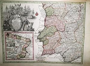
Portugalliae et Algarbiae Regna? Mappa Brasiliae Regn. in America Merid.
Seller: Librer�a Anticuaria Antonio Mateos, Malaga, Spain
Seller Rating:

Augustae Vindelicorum, (1725), mapa grabado en cobre, en colores, con bella cartela, comprende Portugal, parte de Galicia, Toda Extremadura y gran parte de Andaluc�a, llegando hasta la provincia de M�laga y C�rdoba. Contiene en recuadro la provincia portuguesa de Brasil con sus diversas capitan�as. 20 x 26 cm. PORTUGAL BRASIL.
-
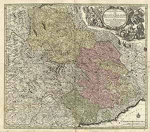
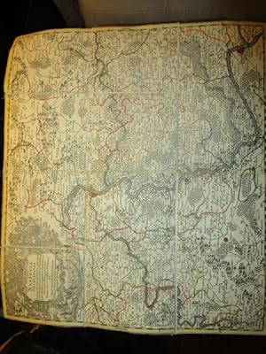
Kein Einband. Condition: Gut. ".Dynastiarum In Hoc Terrae Tractu, Comprehentarum Nova Delineatio Geographica. Studio Et Opera M. Seutter, Geographi Caes. Aug. Vind.". 1 Landkarte betr. Markgrafschaft Ansbach, �ttingen, Pappenheim etc., Kupferstich 50x58cm, fl�chenkoloriert, Grenzkoloriert. 1 illustrierte einfbg. Kartusche mit fig. Darstellung und Wappenabbildungen. Karte mit senkrechter und waagerechter Mittelfalz, 1 Registermarke, einige Flecken am Rand, nur wenig fingerfleckig, guter Zustand. Verzeichnet bei Ch. Sandler: 'Matth�us Seutter und seine Landkarten. Ein Handbuch' S. 15 No.82.
-
Holsatiae mappa universalias in suos ducatus distincta.
Published by Augsburg ca. ,, 1735
Seller: Antiquariat Ruthild J�ger, Lueneburg, Germany
Seller Rating:
Art / Print / Poster
Altkolorierte Kupferstichkarte, 59 x 50 cm. Sehr gut erhalten, Prachtexemplar. * Pr�chtige Karte in leuchtendem zeitgen�ssischem Kolorit. Dargestellt ist der Landesteil Holstein zwischen Elbe und Eider, Fehmarn und Ratzeburg, mit zwei gro�en, dekorativen (nicht ausgemalten) Wappenkartuschen.
-
Regiae Celsitudinis Sabaudicae Status in quo Ducatus Sabaudiae Princitat. Pedemontanium ut et Ducatus Montisferrati.
Published by Piemonte - Savoia
Seller: Sergio Trippini, Gavirate, Italy
Seller Rating:
Carta geografica dei territori del Piemonte e della Savoia. Nell'angolo in alto a destra il titolo si trova iscritto in decorativo cartiglio a volute animato dalla raffigurazione di alcune figure allegoriche. Nell'angolo in basso a destra sono riportate le scale grafiche "Milliaria Germanica communia 15 in uno gradu" e "Miliaria Italica communia". La carta � applicata su supporto cartaceo coevo. Coloritura coeva all'acquerello. Complessivamente gode di un buono stato di conservazione.
-
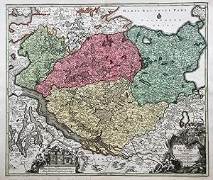
Episcopatus Hildesiensis cum adjacentibus provinciis ac statibus mappa geographica.
Published by Augsburg um ,, 1735
Seller: Antiquariat Ruthild J�ger, Lueneburg, Germany
Seller Rating:
Art / Print / Poster
Altkolor. Kupferstichkarte, 56 x 48 cm. Breitrandiges Prachtexemplar. (#1401AG) * Die dekorative Karte mit gro�er fig�rlicher Kartusche (darin Allegorien auf Jagd, Landwirtschaft, Bergbau u. geistliche Herrschaft) zeigt das Gebiet zwischen Steinhuder Meer, Braunschweig, Wernigerode, G�ttingen und Hameln mit farblicher Differenzierung der einzelnen bisch�flichen �mter.
-
Territorium Sac. Rom. Imp. Lib. Civitatis Francofurti ad Moenum cum Magna parte Archiepiscopatus Moguntini.
Published by Francoforte - Germania
Seller: Sergio Trippini, Gavirate, Italy
Seller Rating:
Carta geografica del territorio di Francoforte. La citt�, al centro della raffigurazione, � disegnata in pianta. Nell'angolo in basso a sinistra un ricco ed animato cartiglio riporta il titolo della carta. Coloritura coeva all'acquerello. Ottima conservazione.
-
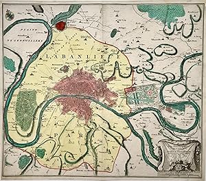
Typus Choro-Topographicus Regiae et totius Orbis celeberrimae Urbis Lutetiae Parisiorum cum circumjacentis territorii oppidis.
Published by Augsburg ca. ,, 1730
Seller: Antiquariat Ruthild J�ger, Lueneburg, Germany
Seller Rating:
Art / Print / Poster Signed
Altkolor. Kupferstichkarte, 58 x 49 cm. (Oberer wei�er Papierrand au�erhalb der Einfassungslinie sorgf�ltig erg�nzt, ansonsten tadelloses Blatt). * Die dekorative Karte zeigt den Grundri� von Paris mit der umgebenden "banlieue" (Bannmeile) bis St.Denis, Vincennes, St.Maur, Choisy, St.Cloud; s�mtliche Schl�sser, D�rfer, Parks und Alleen sind eingezeichnet. Der Kupferstecher Seutter signiert hier noch nicht als kaiserlicher Geograph, sondern noch als "Chalcographus Augustanus" (Augsburger Kupferstecher); es handelt sich somit um eines der seltenen Fr�hwerke Seutters. Une carte informative et d�corative de la "Banlieue de Paris" (montrant la region entre St.Denis, Nogent, St.Maur, Bonneuil, Bourg-la-Reine et St.Cloud), au centre le plan de Paris. La carte en beau coloris de l'�poque. Il s'agit d'une oeuvre de jeunesse du cartographe Seutter, il signe comme "Chalcographus Augustanus" (graveur d'Augsbourg) et pas encore comme g�ographe de l'Emp�reur. (#1981AG).
-

Regio Canaan seu Terra promissionis
Publication Date: 1730
Map
No Binding. Condition: As New. 50 x 58 cm. Richly embellished map of the Holy Land, based on Sanson's map. The kingdom's of Israel and Juday bisect the region, which is divided into 12 tribes. Special symbols identify the cities of kings and preists and the ancient cities of refuge. The mountains, rivers and streams surround Canaan are named. The Sea of Galilee is linked to the Mediterranean. The cartouche was engraved by Gottfried Rogg. A second smaller cartouche includes a map of the exodus from Egypt.
-
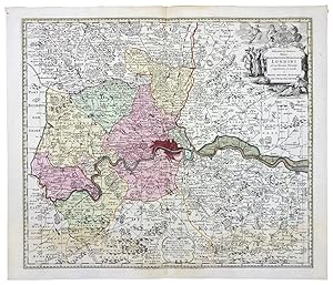
Delineatio ac finitima Regio Magnae Brittaniae metropoleos Londini
Publication Date: 1740
Map
No Binding. Condition: As New. 49,5 x 58 cm. ghly detailed decorative map of London and Environs, extending to Gravesend in the east, Hatfield and St. Albans in the North, Westerham in the South and Uxbridge in the West. The map shows the various towns, roads, churches, fortified cities, rivers, harbors, etc. in and around London, including a town plan. A nice post-fire map of the region, showing the extent of the expansion of London, which would grow to many times the size illustrated here.
-
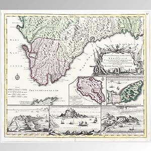
ACCURATA DESIGNATIO CELEBRIS FRETI PROPE ANDALUSIAE CASTELLUM GIBRALTAR
Publication Date: 1730
Seller: LIBRERIA ANTICUARIA MARGARITA DE DIOS, MADRID, Spain
Association Member: LANCE
Seller Rating:
Condition: Bien. Materia: Mapa antiguo del siglo XVIII. Gibraltar. Publicaci�n: c. 1730 Descripci�n: Orientado con rosa con lis. - M�rgenes graduados. - Relieve por montes de perfil. - Hidrograf�a destacada. - Costas sombreadas. - Las ciudades m�s importantes est�n representadas mediante peque�os planos rodeados por fortalezas. En el margen derecho se encuentra el t�tulo en cartela rodeada de banderas y motivos b�licos. Insertadas 5 vistas de las principales ciudades: 1. Insula Minorca ex Balearibus secunda cum Castello Porto Maon quam Angli jam ab Anno 1708 in potestate habent. - 5 millaria Anglica. - 12 x 15 cm. 2. Accurata Delineatio Hispanici Castelli Ceuta in ora Africae siti quod Maroccenses per 34 annos frustra obsederunt. Anno 1727 - 12 x 15 cm. 3. Prospectus celeberrimi Portus Cadix in Hispanico Regno Andalusia. - 12 x 18 cm. 4. Prospectus munitissimi Castelli Gibraltar in Andalusia Hispaniae Regno. - 12 x 21 cm. 5. Prospectus Urbis Malagae in Hispaniae Regno Granada. - 12 x 17 cm. Medidas:490 x 580 mm. Dimensiones total: 490 x 570 mm. T�cnica:Grabado calcogr�fico. Coloreado a mano con acuarela en la �poca. Conservaci�n:Buen estado, ligeras marcas de humedad en el margen inferior. RES1.
-
Praefecturae Saxonicae Wurcensis Eilenbur Gensis Dubensis Geographica accuratione secundum oppida vicos pagos, vicinias descriptae, a Mattaeo Seuttero S.C.M George Aug. Vindel. Cum Privileg S.M. Pol et. Elect Saxon
Published by c. 1740, Germany, 1740
Seller: Alexandre Antique Prints, Maps & Books, Toronto, ON, Canada
Seller Rating:

Map
Condition: Very Good. Map of Central East Germany South of Berlin., Size : 487x560 (mm), 19.17x22.05 (Inches), Original Hand Coloring.
-
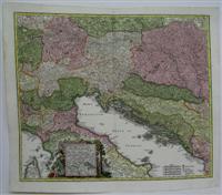
Mare Adriaticum Vulgo Golfo di Venetia
Published by Augsburg, 1740
Seller: Alexandre Antique Prints, Maps & Books, Toronto, ON, Canada
Seller Rating:
Map
Condition: Excellent. A superb mid 18th century depiction of Northern Italy, Slovenia, Croatia and Bosnia Herzegovina. With a decorative cartouche encompassing an inset map in the lower left., Size : 495x580 (mm), 19.5x22.875 (Inches), Original Hand Coloring.
-
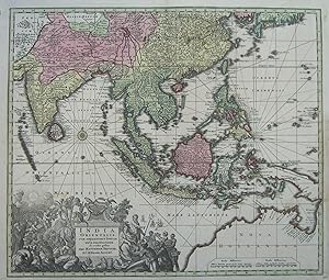
India orientalis, cum adjacentibus insulis.
Published by Augsburg: Seutter ca. ,, 1735
Seller: Antiquariat Ruthild J�ger, Lueneburg, Germany
Seller Rating:
Art / Print / Poster
Altkolor. Kupferstichkarte, 58 x 49 cm. Sehr gut erhalten / in very good condition. * Tooley: Early maps of Australia 74; Tooley: Printed maps of Australia 1137; Parry: East Indian Islands 223. Sehr dekorative Karte des s�dostasiatischen Raumes, vom indischen Subkontinent und Ceylon bis S�d-Japan, Philippinen, Indonesien, Papua und zu der durch die Niederl�nder entdeckten K�ste Nord-Australiens reichend, in Bildmitte Sumatra; mit gro�er fig�rlicher und reich verzierter Kartusche (30 x 14 cm). Plattenzustand noch vor dem Privilegvermerk (1740). A very fine example of this Southeast Asia map, in contemporary colouring; it extends from Southern Japan to the Dutch discoveries in Northern Australia, and includes India, Ceylon, Southern China and all the East Indian archipelago. The map shows an elongated coast of New Guinea conjoined with the Northern coast of Australia. The map is embellished by a wonderfully elaborate and highly decorative allegorical cartouche (30 x 14 cm) showing in symbolic form the religious, commercial and maritime riches of the region, with native figures and European travellers. "One of the most sought after . 18th century maps of Southeast Asia and the East Indian Islands" (P.). (#1009AG).
-
Nova et Accurata Tartariae Europae seu Minoris et in specie Crimeae
Published by Augsburg, 1740
Seller: Alexandre Antique Prints, Maps & Books, Toronto, ON, Canada
Seller Rating:
Map
Condition: Very Good. Fine 18th century map of Ukraine on the lower part of the map, the map depicts Turkey and on the left hand side Romania and Bulgaria is also depicted. In fine strong original colour. , Size : 500x590 (mm), 19.625x23.25 (Inches), Hand Colored.
-
Insula Corsica, olim Regni Titulo Insignis, nunc Genuensis Reipublicae potestati subjecta, juxta recentissimam designationem mappa Geographica aeri ineisa per Matthaeum Seutter, Sac Caes et Reg. Cathol. Majest. Geographum Aug. Vind.
Published by c. 1740, Augsburg, 1740
Seller: Alexandre Antique Prints, Maps & Books, Toronto, ON, Canada
Seller Rating:
Map
Condition: Very Good; Title cartouche vividly coloured depicting four men with market goods with a lion nearby. The island is coloured lightly, divided by regions. Cartouche in upper right contains Latin text, the lower right contains four scales, and the lower left depicts the emblems of Corsica and Genoa., Size : 580x495 (mm), 22.83x19.49 (Inches), Hand Colored.
-
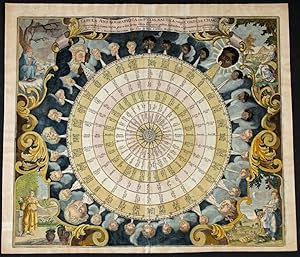
Tabula Anemographica
Seller: Frederik Muller Rare Books BV, Bergen op Zoom, Netherlands
Seller Rating:

Map
Augsburg, c. 1740Copper plate engraving50x57 cmIn contemporary colorSlightly rumpled and strengthened on the fold.Still a highly attractive map with each and every wind a name in six languages, starting in Greek and the four seasons as cartouches in each corner of the map.
-
Regni Japoniae
Seller: Frederik Muller Rare Books BV, Bergen op Zoom, Netherlands
Seller Rating:
Map
Engraved by Tobias LotterAugsburg, c. 1740(Hubbard nr 90)Copper plate engraving47x55 cmVerso: no textContemporary colorCondition; no repairsThe map is after Engelbert Kaempfer s map of 1727 as recognized in the title and cartouche where Kaempfer is drawing a map of Japan after aJapanese example held up for him. The cartouches were usually in black and white so this one may be colored later though improbable given the paper used in printing.
-
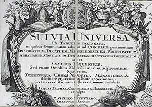
Suevia universa IX. tabulis delineata. (Gesamtschwaben). Altkolorierte Kupferstichkarte in 96 Segmenten, alt auf Leinen montiert und gefaltet, ausgelegt ergibt sich ein Format von 147 x 158 cm. Mit gestoch. Legende und 2 Kartuschen.
Published by Augsburg, M. Seutter, (nach 1725.), 1725
Seller: Antiquariat F. Neidhardt, B�blingen, Germany
Seller Rating:
In mod. Halbleder-Kassette mit R�ckentitel. Cartographia Bavariae S. 113 und 4.13: "Als wichtigstes und bestes Werk mit dem Thema Schw�bischer Reichskreis gilt die Karte von Jaques de Michal. Stellt das Hauptwerk im schw�bischen Raum mit einer bis zum Ende des 18. Jahrhunderts ausgreifenden Wirkung dar." Michal war Ingenieuroffizier bei der Truppe des Schw�bischen Kreises. Die Karte umfasst den s�ddeutschen Raum vom Rhein bis zum Lech mit n�rdl. Begrenzung Crailsheim und Jagst und s�dl. Begrenzung Z�richer See und Vaduz. Sch�nes, kr�ftiges Fl�chen- und Grenzkolorit, die Kartuschen unkoloriert. Die Karte erschien in 9 Teilen, das vorliegende Exemplar wurde hier sorgf�ltig von alter Hand in kleinen Segmenten als Falt- oder Wandkarte pr�pariert. Zwei Segmente mit winziger Wurmspur, ansonsten sehr gut erhalten.- Oehme 118 und Abb. 33: "Beste Kreiskarte des 18. Jahrhunderts." Sprache: lateinisch.
-
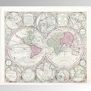
DIVERSI GLOBI TERR-AQUEI STATIONE VARIANTE ET VISU INTERCEDENTE PER COLUROS TROPICORUM, PER AMBOS POLOS ET PARTICUL SPHAERAE ZENITH IN PLANUM DELINEATI ORTHOGRAPHICI PROSPECTUS
Publication Date: 1735
Seller: LIBRERIA ANTICUARIA MARGARITA DE DIOS, MADRID, Spain
Association Member: LANCE
Seller Rating:
Condition: Bien. Materia: Cartograf�a antigua. Mapamundi. S. XVIII. Publicaci�n: c.1735. Descripci�n: Enprimer plano representados dos grandes hemisferios, a la derecha el Viejo Mundo y a la izquierda el Nuevo Mundo. La cartela con el t�tulo est� en la parte superior a la izquierda y a su derecha breve explicaci�n de las diferentes perspectivas, mapas y sus autores. Los continentes y las fronteras est�n coloreados. En la parte inferior hay tres hemisferios polares y a ambos lados hay dos hemisferios centrados en los oc�anos Pac�fico e �ndico. El Polo Norte est� en la parte superior del mapa a su lado dos mapas que se centran en los polos en Europa y Australia, respectivamente. Adem�s, hay cuatro globos peque�os con informaci�n sobre m�todos de navegaci�n. De particular inter�s es California, que se muestra en el mapa como una Isla. El tama�o de Jap�n es grande y llamativo. Australia no se representa completa. Todos los mapas est�n muy detallados. El cart�grafo Matth�us Seutter (1678-1756) fue alumno del reconocido cart�grafo alem�n Johann Baptist Homann. En Nuremberg, Seutter aprendi� cartograf�a. En 1707 cre� su propia imprenta haciendo muchos trabajos. Sutter fue influenciado Homann y Delisle. Su trabajo ser� continuado por su hijo Tobias Conrad Lotter. T�cnica: Grabado calcogr�fico, coloreado a mano con acuarela en la �poca. Medidas: 50 x 58 cm. Conservaci�n: Buen estado. RRCS2.
-
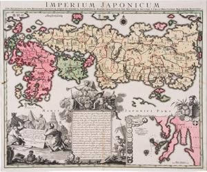
Imperium Japonicum,
Published by Augsburg, 1740
Map
No Binding. Condition: Very Good. per sexaginata et sex Regiones Digestum Atque ex Ipsorum Japonensium Mappis Descriptum per Matthaeum Seutter. 46.5 x 57.5cm. Original engraved map, hand colored. Walter Japan 63. map.
-
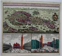
Venetia Potentissima e la piu Magnifica, Fiorentissima e la pui ricca Citta Capitale della Serenissima. . .
Published by Augsburg, 1730
Seller: Alexandre Antique Prints, Maps & Books, Toronto, ON, Canada
Seller Rating:
Map
Condition: Very Good, Superb decorative map of Venice with attractive original hand coloring., Size : 500x580 (mm), 19.625x22.875 (Inches), Original Hand Coloring.
-
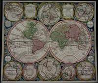
Diversi Globi Terr-Aquei Statione Variante et Visu Intercedente per Coluros Tropicorum. . .
Published by Augsburg, 1740
Seller: Alexandre Antique Prints, Maps & Books, Toronto, ON, Canada
Seller Rating:
Map
Condition: Very Good. Large, impressive double-hemisphere map of the world, surrounded by eight hemispheres of various projections of the world, mostly polar. The coastlines of Australia and New Zealand are beginning to take shape. The map is filled with detail including the tracks of several explorers. The background consists of richly engraved clouds with numerous wind heads, lesser spheres and two cartouches., Size : 505x585 (mm), 19.875x23 (Inches), Hand Colored, 0.

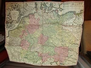
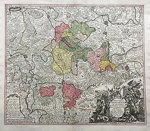
![Seller image for Marchionatus Onoldini Comitatus Oettingensis Praepositurae Elevacensis Et Pappenheimensis. - Markgrafschaft Ansbach �ttingen Pappenheim - 1 Landkarte, Kupferstich [1740] for sale by Antiquariat Lastovka GbR](https://pictures.abebooks.com/inventory/md/md30436188027.jpg)