
Order Total (1 Item Items):
Shipping Destination:

Louisiana Mouth of Mississippi (1 results)
Skip to main search results
Product Type
- All Product Types
- Books
- Magazines & Periodicals
- Comics
- Sheet Music
- Art, Prints & Posters (1)
- Photographs
- Maps
-
Manuscripts &
Paper Collectibles
Condition
- All Conditions
- New
- Used
Binding
- All Bindings
- Hardcover
- Softcover
Collectible Attributes
- First Edition
- Signed
- Dust Jacket
- Seller-Supplied Images
- Not Printed On Demand
Seller Location
Seller Rating
-
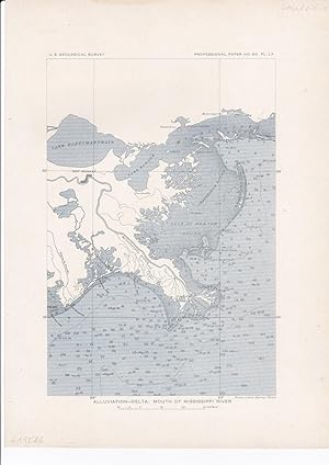
Alluviation-delta: Mouth of MIssissippi River.
Published by Washington, D.C.: Government Printing Office ,, 1908
Seller: Antiquariat Ruthild J�ger, Lueneburg, Germany
Seller Rating:

Art / Print / Poster
Lithography in two-colour-printing (black, blue), 20 x 28 cm (= 7 x 11 in). In very good state of conservation. (from U. S. Geological Survey, 1908). * The precisely engraved map shows the Mouth of the Mississippi River, from Lake Pontchartrain and New Orleans to Chandeleur Islands and to Bayou la Fourche; with water depth contours and topographic details. (#6115AG).