Order Total (1 Item Items):
Shipping Destination:

John Bartholomew & Son Ltd (81 results)
Skip to main search results
Product Type
- All Product Types
- Books (61)
- Magazines & Periodicals
- Comics
- Sheet Music
- Art, Prints & Posters
- Photographs
- Maps (20)
-
Manuscripts &
Paper Collectibles
Condition
- All Conditions
- New
- Used
Binding
Collectible Attributes
- First Edition (5)
- Signed (3)
- Dust Jacket (2)
- Seller-Supplied Images (54)
- Not Printed On Demand
Free Shipping
Seller Location
Seller Rating
-
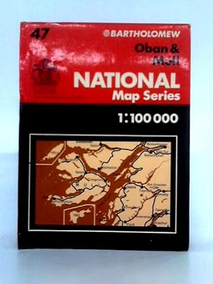
Condition: Good. 1977. No Edition Remarks. Unpaginated. Pictorial paper cover with colour illustrated map of Oban and Mull. Scale 1:100,000. Series 47. Map is lightly tanned to edges, with minimal thumb marking and some light scuffing to folds. Paper cover has mild edge-wear with some mild creasing. Small tears to edges. Light sunning to spine and edges.
-

Bartholomew Half Inch Map Series, No. 61: Orkney
Published by John Bartholomew & Son, Ltd.
Seller: Wonder Book, Frederick, MD, U.S.A.
Seller Rating:

Condition: Good. Good condition. No. 61 - Half Inch Map Series. ISBN: 0851520618. (Orkney, Scottish Isles, Map).
-

Condition: Good. Most items will be dispatched the same or the next working day. Nice later edition with the red cloth boards. Book in exceptional condition. Boards look almost new with good vibrant colour and nice design work on the front. Spine is strong and inline. All the pages are intact and well bound with good colour free from marks, stains or annotations. A nice example for collectors.
-
Derbyshire and the Peak District (Revised and Reprinted)
Published by Penguin Books Ltd. / Penguin Guides, London and Maidstone, 1949
Wraps. John Bartholomew & Son Ltd., Edinburgh (maps copyright by) (illustrator). First, March 1939. 169p. Green-toned Maps, center section. Other maps. Index. Publisher catalogue. Orange, gray, black & white covers. Very good. No dust jacket as issued. Pencil marks on front cover outlined Great Britain. 0 0.0.
-

The Random House Mini World Atlas
Published by Random House Inc, New York, 1985
ISBN 10: 0394740084ISBN 13: 9780394740089
Book
Paperback. Condition: Very Good. This copy is FINE; the text is clear, bright, and unmarked; binding is tight. The covers also fine: absolutely intact in all ways, including perfect color and design but price sticker bottom rear. We have a five star rating because of our fulfilment success and because our descriptions are accurate. We ship all books to U.S. buyers with Tracking. We guarantee: NO NASTY SURPRISES.
-
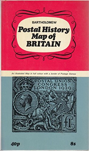
Postal history map of Britain
Published by HarperCollins Distribution Services, 1970
ISBN 10: 0851525407ISBN 13: 9780851525402
Map
Map. Condition: Very Good.
-
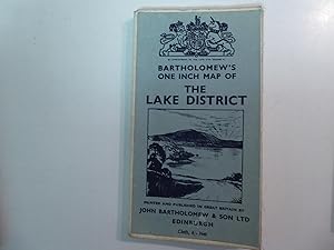
Bartholomew's One inch Map of THE LAKE DISTRICT. Faltkarte
Published by John Bartholomew & Son Ltd., Edinburgh
Map
Softcover. Condition: gut. 130 g. englisch ohne Seitenzahlen pages.
-
The New York Times Atlas of the World: In Collaboration with The Times of London
Published by New York Times Book Co. / Quadrangle., New York NY., 1972
Hard cover. Dark blue cloth over boards. Blind-stamped front titles. Gold spine titles. Blue top page block. Illustrations, Maps. 11x15 in. End papers, map plate keys. "Maps prepared and printed in Great Britain by John Bartholomew & Son Limited, Edinburgh." "Conurbation maps compiled and drawn by Fairey Surveys Limited, Maidenhead; A.W. Gatrell; and Hunting Surveys Limited." "Comparative tables of Pinyin and Wade. Very good. No dust jacket. Signed by previous owner. Minor edge wear. Back cover: a few small blemishes.
-
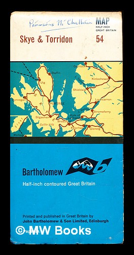
Map: Half-Inch Great Britain: 54: Skye & Torridon
Published by Edinburgh: John Bartholomew & Son, Ltd
First Edition
First Edition. Good folding map in the original stiff-card wrappers; edges slightly nicked and dust-dulled as with age. Includes previous owner's signature. Physical description; 1 folding map. Notes; No clear publication date given. Subjects; Isle of Skye. Torridon. Scotland. Folding maps. John Bartholomew & Son, Ltd. 1 Kg.
-
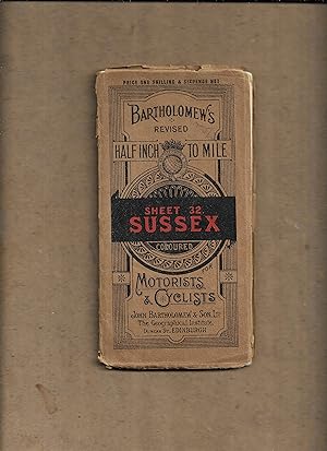
Bartholomew's revised half inch to mile. Sheet 32. Sussex, coloured, for motorists and cyclists.
Published by John Bartholomew and Son Ltd
Map
Soft cover. Condition: Fair. No Jacket. 1 folded col. map. Map complete but torn around folds. [Sussex - England - maps]. No publication date. r512 / m14222.
-
Bartholomew's Quarter-inch Automobile Map of Great Britain Sheet 2 Dingwall-Portree
Published by John Bartholomew & Son Ltd, Edinburgh, 1933
Paperback. Condition: Good+. Second printing. sections on linen. Book.
-
2233.JOHN BARTHOLOMEW & SONS LTD. 19-- (EARLY) MAP OF AFRICA. LAND OF MANY LANDS. LARGE FOLD OUT MAP ON HARD PAPER. VERY GOOD CONDITION. (OBG-BASE-79).
-

Map: Half-Inch Great Britain: 54: Skye & Torridon
Published by Edinburgh: John Bartholomew & Son, Ltd
First Edition
First Edition. Good folding map in the original stiff-card wrappers; edges slightly nicked and dust-dulled as with age. Includes previous owner's signature. Physical description; 1 folding map. Notes; No clear publication date given. Subjects; Isle of Skye. Torridon. Scotland. Folding maps. John Bartholomew & Son, Ltd. 1 Kg.
-
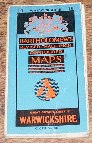
Warwickshire - Bartholomew's Revised "Half-Inch" Contoured Maps, Great Britain Sheet 19
Published by John Bartholomew & Son Ltd., Edinburgh, 1957
Softcover. Condition: Very Good. Dust Jacket Condition: No Dust Jacket. Revised Edition. Single sheet map is cloth backed and has blue card covers. Sheet is folded as for original sale. Scale 1:126,720 or Half-Inch to Mile. Map is coloured according to contour and main roads are shown in red. Rivers, railways, canals, etc. are clearly indicated. A and B road numbers are given. County boundaries and Overhead Electrical Power Lines also shown. Covers are slightly marked. Sheet is slightly worn and darkened around the edges. The folds are a little worn, rubbed and deteriorated. Area covered includes; Birmingham, Walsall, Wolverhampton, Coventry, Warwick, Leamington, Rugby, Leicester (part), Northampton, Wellingborough, Kettering, Towcester, Tamworth. Size: 86x59cm. Single sheet map/chart which is suitable for framing. Quantity Available: 1. Shipped Weight: under 1 kg. Pictures of this item not already displayed here available upon request. Inventory No: 45119093007. For International tracked shipping please select the Priority shipping service.
-
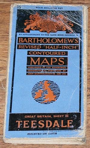
Teesdale - Bartholomew's Revised "Half-Inch" Contoured Maps, Great Britain Sheet 35
Published by John Bartholomew & Son Ltd., Edinburgh, 1947
Softcover. Condition: Good. Dust Jacket Condition: No Dust Jacket. Revised Edition. Single sheet map is mounted on cloth and has blue card covers. Sheet is folded as for original sale. Scale 1:126,720 or Half-Inch to Mile. Map is coloured according to contour and main roads are shown in red. Rivers, railways, canals, etc. are clearly indicated. A and B road numbers are given. County boundaries and Overhead Electrical Power Lines also shown. Covers are worn and a little marked and rubbed. Sheet is slightly worn and darkened around the edges. Several folds have short splits at the edges and the folds are worn and in places deteriorated. Area covered includes; West Hartlepool, Middlesborough, Darlington, Ripon, Kirkby Lonsdale, Richmond, Middleham, Leyburn, Barnard Castle, Appleby, Bishop Auckland. Size: 84x57cm. Single sheet map/chart which is suitable for framing. Quantity Available: 1. Shipped Weight: under 1 kg. Pictures of this item not already displayed here available upon request. Inventory No: 45119093006. For International tracked shipping please select the Priority shipping service.
-
Cardigan - Bartholomew's Revised "Half-Inch" Contoured Maps of England and Wales, Sheet 22 (E4)
Published by John Bartholomew & Son Ltd., Edinburgh, 1938
Softcover. Condition: Very Good. Dust Jacket Condition: No Dust Jacket. Revised Edition. Single sheet map is cloth backed and has blue card covers. Sheet is folded as for original sale. Scale 1:126,720 or 2 Miles to an Inch. Map is coloured according to contour and main roads are shown in red. Rivers and railways are clearly indicated. A and B road numbers are given. Sheet is worn at some folds, in places the paper has worn through but cloth holds firm. Edges are worn and a little darkened, map remains bright and clear. Covers are a little marked and scuffed. Area covered includes; Aberystwyth, Aberayron, New Quay, Cardigan, Llanddyssul, Llandovery, Brecon, Tregaron, Builth Wells, Rhayader, Llanidloes, Lampetter. Single sheet map/chart which is suitable for framing. Quantity Available: 1. Shipped Weight: under 1 kg. Pictures of this item not already displayed here available upon request. Inventory No: 45119103051. For International tracked shipping please select the Priority shipping service.
-
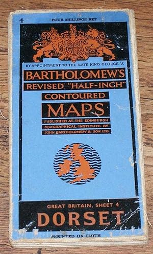
Dorset - Bartholomew's Revised "Half-Inch" Contoured Maps, Great Britain Sheet 4
Published by John Bartholomew & Son Ltd., Edinburgh, 1947
Softcover. Condition: Very Good. Dust Jacket Condition: No Dust Jacket. Revised Edition. Single sheet map is cloth backed and has blue card covers. Sheet is folded as for original sale. Scale 1:126,720 or Half-Inch to Mile. Map is coloured according to contour and main roads are shown in red. Rivers, railways, canals, etc. are clearly indicated. A and B road numbers are given. County boundaries and Overhead Electrical Power Lines also shown. Covers are clean but a little scuffed. Sheet is slightly worn and darkened around the edges. The folds are a little worn and deteriorated in places. Previous owner's name on reverse. Area covered includes; Yeovil, Sidmouth, Bridport, Weymouth, Portland, Dorchester, Wareham, Poole, Sherborne, Taunton, Lyme Regis, Crewkerne. Size: 83x59cm. Single sheet map/chart which is suitable for framing. Quantity Available: 1. Shipped Weight: under 1 kg. Pictures of this item not already displayed here available upon request. Inventory No: 45119093035. For International tracked shipping please select the Priority shipping service.
-
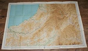
Teesdale - Bartholomew's Revised "Half-Inch" Contoured Map of England & Wales, Sheet 4
Published by John Bartholomew & Son Ltd., Edinburgh, 1932
Softcover. Condition: Very Good. Dust Jacket Condition: No Dust Jacket. Revised Edition. Single sheet map is dissected and mounted on cloth and has blue card covers. Sheet is folded as for original sale. Scale 1:126,720 or 2 Miles to an Inch. Map is coloured according to contour and main roads are shown in red. Rivers, railways, canals, etc. are clearly indicated. A and B road numbers are given. Covers are a little worn and rubbed. Sheet is slightly worn and darkened around the edges but map is bright and clear. Minor annotation in bottom left margin. Area covered includes; West Hartlepool, Middlesborough, Durham, Darlington, Northallerton, Barnard Castle, Middleton, Bishop Auckland, Stockton on Tees, Richmond. Undated by publisher. Single sheet map/chart which is suitable for framing. Estimated date only. Quantity Available: 1. Shipped Weight: under 1 kg. Pictures of this item not already displayed here available upon request. Inventory No: 45119103042. For International tracked shipping please select the Priority shipping service.
-
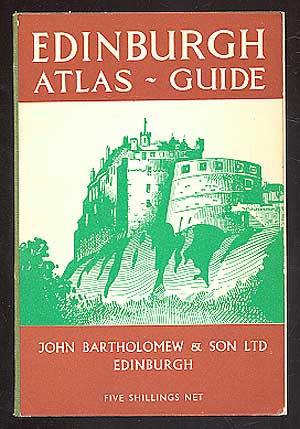
Edinburgh Atlas-Guide
Published by John Bartholomew & Son Ltd, Edinburgh, 1961
Seller: Between the Covers-Rare Books, Inc. ABAA, Gloucester City, NJ, U.S.A.
Association Member: ABAA ESA ILAB IOBA
Seller Rating:
Softcover. Condition: Fine. Third edition. Paperback. Maps. Illustrations. Creases on some pages, minor wear to the corners, else a fine copy in wrappers.
-
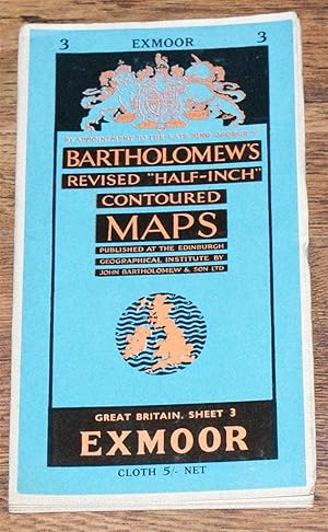
Exmoor - Bartholomew's Revised "Half-Inch" Contoured Maps, Great Britain Sheet 3
Published by John Bartholomew & Son Ltd., Edinburgh, 1962
Softcover. Condition: Very Good. Dust Jacket Condition: No Dust Jacket. Revised Edition. Single sheet map is cloth backed and has blue card covers. Sheet is folded as for original sale. Scale 1:126,720 or Half-Inch to Mile. Map is coloured according to contour and main roads are shown in red. Rivers, railways, canals, etc. are clearly indicated. A and B road numbers are given. County boundaries and Overhead Electrical Power Lines also shown. Covers are clean. Sheet is slightly worn and darkened and worned around the edges. The folds are a little rubbed and in some instances slightly darkened. Area covered includes; Exeter, Crediton, Tiverton, Cullumpton, Watchet, Minehead, Ilfracombe, Barnstaple, Okehampton, Hatherleigh, Bideford, Great Torrington, Bampton, Dunster. Size: 86x59cm. Single sheet map/chart which is suitable for framing. Quantity Available: 1. Shipped Weight: under 1 kg. Pictures of this item not already displayed here available upon request. Inventory No: 45119093012. For International tracked shipping please select the Priority shipping service.
-
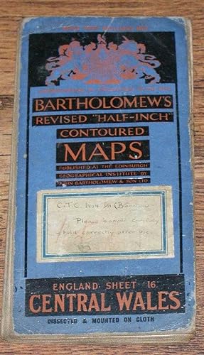
Central Wales - Bartholomew's Revised "Half-Inch" Contoured Maps of England and Wales, Sheet 16
Published by John Bartholomew & Son Ltd., Edinburgh, 1935
Softcover. Condition: Good. Dust Jacket Condition: No Dust Jacket. Revised Edition. Single sheet map is backed with cloth and has blue card covers. Sheet is folded as for original sale. Scale 1:126,720 or 2 Miles to an Inch. Map is coloured according to contour and main roads are shown in red. Sheet is worn and darkened along the edges and folds, some folds have worn through but sheet is held sound by cloth backing. Covers are a little darkened, remains of revised price label on front cover. Area covered includes; Cardigan Bay, Aberystwyth, Aberdovey, Machynlleth, Barmouth, Dolgelley, Newtown, Llanidloes, Montgomery, Rhayader, Llanrhaladr Yn Mochnant, Welshpool. Single sheet map/chart which is suitable for framing. Quantity Available: 1. Shipped Weight: under 1 kg. Pictures of this item not already displayed here available upon request. Inventory No: 45119103056. For International tracked shipping please select the Priority shipping service.
-
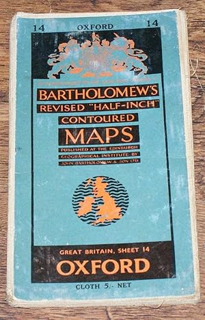
Oxford - Bartholomew's Revised "Half-Inch" Contoured Maps, Great Britain Sheet 14
Published by John Bartholomew & Son Ltd., Edinburgh, 1955
Softcover. Condition: Good. Dust Jacket Condition: No Dust Jacket. Revised Edition. Single sheet map is cloth backed and has blue card covers. Sheet is folded as for original sale. Scale 1:126,720 or Half-Inch to Mile. Map is coloured according to contour and main roads are shown in red. Rivers, railways, canals, etc. are clearly indicated. A and B road numbers are given. County boundaries and Overhead Electrical Power Lines also shown. Covers are worn. Sheet is slightly worn and darkened around the edges. The folds are worn, rubbed and deteriorated in places. Partial splits at ends of one fold. Area covered includes; Oxford, Bicester, Banbury, Woodstock, Cheltenham, Cirencester, Swindon, Abingdon, High Wycombe, Wallingford, Aylesbury, Buckingham, Leighton Buzzard. Size: 86x59cm. Single sheet map/chart which is suitable for framing. Quantity Available: 1. Shipped Weight: under 1 kg. Pictures of this item not already displayed here available upon request. Inventory No: 45119093011. For International tracked shipping please select the Priority shipping service.
-
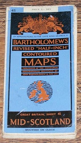
Mid-Scotland - Bartholomew's Revised "Half-Inch" Contoured Maps, Great Britain Sheet 45
Published by John Bartholomew & Son Ltd., Edinburgh, 1951
Softcover. Condition: Very Good. Dust Jacket Condition: No Dust Jacket. Revised Edition. Single sheet map is cloth backed and has blue card covers. Sheet is folded as for original sale. Scale 1:126,720 or Half-Inch to Mile. Map is coloured according to contour and main roads are shown in red. Rivers, railways, canals, etc. are clearly indicated. A and B road numbers are given. County boundaries and Overhead Electrical Power Lines also shown. Covers are slightly scuffed. Sheet is slightly worn and darkened around the edges. The folds are a little worn with some small tears at the edges. Area covered includes; River Forth, Firth of Forth, Dunfermline, Stirling, Denny, Kinross, Edinburgh, Loch Lomand, River Clyde, Glasgow, Paisley, Dunblane, Alloa. Size: 84x59cm. Single sheet map/chart which is suitable for framing. Quantity Available: 1. Shipped Weight: under 1 kg. Pictures of this item not already displayed here available upon request. Inventory No: 45119093019. For International tracked shipping please select the Priority shipping service.
-
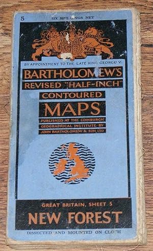
New Forest - Bartholomew's Revised "Half-Inch" Contoured Maps, Great Britain Sheet 5
Published by John Bartholomew & Son Ltd., Edinburgh, 1947
Softcover. Condition: Good. Dust Jacket Condition: No Dust Jacket. Revised Edition. Single sheet map is dissected and mounted on cloth and has blue card covers. Sheet is folded as for original sale. Scale 1:126,720 or Half-Inch to Mile. Map is coloured according to contour and main roads are shown in red. Rivers, railways, canals, etc. are clearly indicated. A and B road numbers are given. County boundaries and Overhead Electrical Power Lines also shown. Covers are lightly stained and scuffed. Sheet is slightly worn and darkened around the edges. Area covered includes; Isle of Wight, Southampton, Portsmouth, Chichester, Bognor Regis, Lymington, Bournemouth, Poole Harbour, Swanage, Salisbury, Winchester. Size: 86x59cm. Single sheet map/chart which is suitable for framing. Quantity Available: 1. Shipped Weight: under 1 kg. Pictures of this item not already displayed here available upon request. Inventory No: 45119093036. For International tracked shipping please select the Priority shipping service.
-
Birmingham District, also Leicester, etc. - Bartholomew's New Reduced Survey of England and Wales, Sheet 18, Scale 2 Miles to an Inch, Coloured for Tourists and Cyclists
Published by John Bartholomew & Son Ltd., Edinburgh, 1912
Softcover. Condition: Very Good. Dust Jacket Condition: No Dust Jacket. Revised Edition. Single sheet map is dissected and mounted on cloth and has blue card covers. Sheet is folded as for original sale. Scale 1:126,720 or Half Inch to Mile. Map is coloured according to contour and main roads, railways, canals, etc. are clearly indicated. Cyclists' Touring Club logo in bottom margin. Sheet is slightly worn and crinkled with a little darkening at the edges but the map remains bright and clear. Covers are lightly worn with two black labels on front cover giving price and title. Area covered includes; Birmingham, Leicester, Coventry, Warwick, Leamington, Northampton, Rugby, Stratford-upon-Avon, Wolverhampton (Part), Walsall, Lichfield. Undated by publisher. Single sheet map/chart which is suitable for framing. Estimated date only. Quantity Available: 1. Shipped Weight: under 1 kg. Pictures of this item not already displayed here available upon request. Inventory No: 45119103038. For International tracked shipping please select the Priority shipping service.
-
ARABIAN PENINSULA, Travel Map, Scale 1: 3000000. *
Published by John BARTHOLOMEW & SON Ltd., * * * * *, 1982
Map
Soft cover. Condition: Fine. 1982 Map, In Fine/ Condition (illustrator). Map, In Fine/ Condition $35.14 ARABIAN PENINSULA, Travel Map, Scale 1: 3000000. John BARTHOLOMEW & SON Ltd. John BARTHOLOMEW & SON Ltd. 1982 Green Colored Front Cover Folder With Title In Black And White Letters, Soft Cover Folder: Near Fine/, Containing One Soft Folding Map, In Fine/, Condition. Were Lightly Viewed, Clean And Tight To The Spine, Printed On Off White Paper, In Fine/ Condition. Had Light Use. No Book Plate Or Prior Owner?s Name Inside. D/j: None. Description Applies To This B0K, Only, Which Is Hard To Find, And Will Be = Packaged And Shipped Carefully, To Avoid Shipping Damage And Will Make It, An Excellent Addition To Your Own Personal Library Collection, Or As A Gift For The Collector / Reader. WORLD WIDE SHIPPING, AVAILABLE.
-
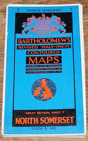
North Somerset - Bartholomew's Revised "Half-Inch" Contoured Maps, Great Britain Sheet 7
Published by John Bartholomew & Son Ltd., Edinburgh, 1960
Softcover. Condition: Very Good. Dust Jacket Condition: No Dust Jacket. Revised Edition. Single sheet map is cloth backed and has blue card covers. Sheet is folded as for original sale. Scale 1:126,720 or Half-Inch to Mile. Map is coloured according to contour and main roads are shown in red. Rivers, railways, canals, etc. are clearly indicated. A and B road numbers are given. County boundaries and Overhead Electrical Power Lines also shown. Covers are clean. Sheet is very slightly worn and darkened around the edges and some folds. Area covered includes; Bristol, Cardiff, Newport, Weston Super Mare, Caerphilly, River Severn, Severn Road Bridge (Proposed), Chepstow, Portshead, Mendip Hills, Bath, Radstock, Frome, Warminster, Chippenham, Tetbury, Devizes, Salisbury Plain, Glastonbury, Bridgwater. Size: 59x86cm. Single sheet map/chart which is suitable for framing. Quantity Available: 1. Shipped Weight: under 1 kg. Pictures of this item not already displayed here available upon request. Inventory No: 45119093003. For International tracked shipping please select the Priority shipping service.
-
Grampians - Bartholomew's Revised "Half-Inch" Contoured Maps, Great Britain Sheet 51
Published by John Bartholomew & Son Ltd., Edinburgh, 1952
Softcover. Condition: Good. Dust Jacket Condition: No Dust Jacket. Revised Edition. Single sheet map is cloth backed and has blue card covers. Sheet is folded as for original sale. Scale 1:126,720 or Half-Inch to Mile. Map is coloured according to contour and main roads are shown in red. Rivers, railways, canals, etc. are clearly indicated. A and B road numbers are given. Covers are clean but slightly worn. Sheet is slightly worn and darkened around the edges. The folds are a little worn and rubbed. Some very small tears at edges of folds and minor fraying to cloth backing. Area covered includes; Ben Nevis, Pitlochry, Loch Lochy, Loch Ness (part), Badenoch, Forest of Atholl, Blair Atholl, Kirkmichael, Glen Ey Forest, Cairngorm Mountains, Struan, Loch Rannoch, Loch Ericht, Gaick Forest. Size: 58x83cm. Single sheet map/chart which is suitable for framing. Quantity Available: 1. Shipped Weight: under 1 kg. Pictures of this item not already displayed here available upon request. Inventory No: 45119093005. For International tracked shipping please select the Priority shipping service.
-
Central Wales - Bartholomew's Revised "Half-Inch" Contoured Maps, England Sheet 16
Published by John Bartholomew & Son Ltd., Edinburgh, 1930
Softcover. Condition: Good. Dust Jacket Condition: No Dust Jacket. Revised Edition. Single sheet map is dissected and mounted on cloth and has blue card covers. Sheet is folded as for original sale. Scale 1:126,720 or Half-Inch to Mile. Map is coloured according to contour and main roads are shown in red. Covers are worn and the front cover has a hand annotated sticker. Sheet is slightly worn and darkened around the edges. Area covered includes; Cardigan Bay, Aberystwyth, Aberdovey, Machynlleth, Barmouth, Dolgelley, Newtown, Llanidloes, Montgomery, Rhayader, Llanrhaladr Yn Mochnant, Welshpool. Size: 74x59cm. Undated by publisher. Single sheet map/chart which is suitable for framing. Estimated date only. Quantity Available: 1. Shipped Weight: under 1 kg. Pictures of this item not already displayed here available upon request. Inventory No: 45119093028. For International tracked shipping please select the Priority shipping service.
-
Peterhead & Banff - Bartholomew's New Reduced Survey of Scotland, Sheet 22, Half Inch to Mile, Coloured for Tourists and Cyclists
Published by John Bartholomew & Son Ltd., Edinburgh, 1912
Softcover. Condition: Very Good. Dust Jacket Condition: No Dust Jacket. Revised Edition. Single sheet map is dissected and mounted on cloth and has blue card covers. Sheet is folded as for original sale. Scale 1:126,720 or Half Inch to Mile. Map is coloured according to contour and main roads, railways, canals, etc. are clearly indicated. Cyclists' Touring Club logo in bottom margin. Sheet is slightly worn and crinkled with a little darkening at the edges but the map remains bright and clear. Covers are lightly worn and marked with two black labels on front cover giving price and title. Area covered includes; Aberdeen, Peterhead, Fraiserburgh, Cullen, Banff, Macduff, Portsoy, Keith, Turriff, Inverurie, Newburgh, Buchaness. Undated by publisher. Single sheet map/chart which is suitable for framing. Estimated date only. Quantity Available: 1. Shipped Weight: under 1 kg. Pictures of this item not already displayed here available upon request. Inventory No: 45119103041. For International tracked shipping please select the Priority shipping service.