About this Item
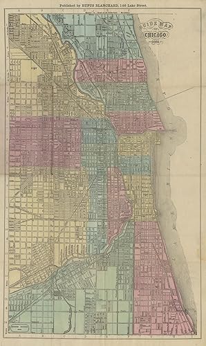
24mo, original printed tan paper covers. 24 pp., hand-colored folding map, 18.625" x 11.25" plus margins. CONDITION: Good, covers toned with small stains, portion of letter G in word "Guide" on cover skinned off, a bit of separation along folds in map. A scarce pocket map of Chicago, depicting the Windy City before the Great Fire of October 1871. Showing the city between Egan Avenue in the south and Fullerton Avenue in the north, this map provides a detailed street-by-street layout. Bordering Lake Michigan to the east of the Chicago River are densely developed residential and commercial areas, while to the west of the river the Jeffers and Union Park areas are quite developed as well, while to the north and south are many blocks apparently as yet undeveloped. Dissecting and connecting the disparate neighborhoods are numerous rail lines owned by the Pittsburgh Ft. Wayne & Chicago Railroad, the Michigan Southern Railroad, the Blue Island Railroad, the Chicago, South Burlington, and Quincy Railroad, and others. A line extending into Lake Michigan at the upper right represents the Chicago Lake Tunnel, one of the great engineering feats of the period, through which fresh water was brought into the city from a crib situated two miles out. Rufus Blanchard (1822-1904) was a mapmaker, historian, painter, and occasional bookseller, and one of the best known citizens of Chicago in the nineteenth century. According to his obituary in The Mattoon Commercial, Blanchard held an international reputation as a cartographer by the end of his life and used the relatively new technique of cerography to print his maps. Hailing from the East Coast, where he worked for Harper & Brothers, during the early 1840s he operated several book stores in Lowell and in Cincinnati. By 1849, he moved to New York to study cartography, and by 1854 brought his expertise to Chicago where he began making and printing railroad maps from his Chicago Map Store. His business was partially destroyed in the Great Chicago Fire of 1871, but partially recovered after he moved his remaining tools etc. to his home in Wheaton. Unfortunately, in 1885, a major fire broke out on Wheaton's Front Street and spread to Blanchard's home and office, destroying his library, historical maps, drawings, notes, and tools. Nevertheless, Blanchard persevered and continued both making maps and writing, mostly about the early pioneers, until his death in 1904. Blanchard was a giant among the Chicago-based mapmakers and sellers of the nineteenth century. Along with "booksellers David B. Cooke, the Burleys, and Keen & Lee," Blanchard "published maps in the mid-1850s, often in collaboration with.other Chicago lithographers.In the decade from 1861 to 1871, map publishers increased from four to six, and specialized services like map coloring and map finishing came to be separately advertised. The prolific Charles Shober joined the ranks of lithographers, and Warner and Higgins (later Warner and Beers) established their county atlas business in 1869" (Conzen and Karrow). This particular edition of Blanchard's guide is not in the Rumsey Collection, which includes two other editions with distinctly different maps, both with surrounding vignette illustrations, published in 1867 and 1869. REFERENCES: "Had an International Reputation," The Mattoon Commercial (Mattoon, Illinois), January 7, 1904; "Fire Destroys Mapmaker's Work but not His Spirit," Chicago Tribune, October 18, 1998; Conzen, Michael and Robert W. Karrow, Jr., "Mapmaking and Map Publishing," at Encyclopedia of Chicago online. Seller Inventory # 8972
Contact seller
Report this item
![]()

