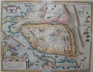
Chinae, olim Sinarum regionis nova descriptio. (.)
Abraham Ortelius
From
Antiquariaat Dat Narrenschip, Middelburg, Netherlands
Seller rating 5 out of 5 stars
![]()
AbeBooks Seller since 09 August 2021
About this Item
Description:
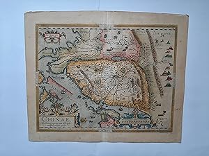
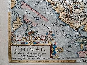
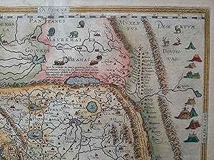
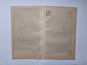
Antique map of China. Title cartouche bottom left. Scale sticks in cartouche bottom right. Latin text on the back. The map is particularly decorative. Beautiful peace. Hand-coloured copper engraving, published in Antwerp in 1595 by Officina Plantin in 'Theatrum Orbis Terrarum,' Abraham Ortelius. Dimensions (image): 37 x 48 cm. Seller Inventory # ABE-1644427070054
Bibliographic Details
Title: Chinae, olim Sinarum regionis nova ...
Publication Date: 1595
Binding: No Binding
Condition: Fine
Top Search Results from the AbeBooks Marketplace
Chinae, olim Sinarum regionis, nova descriptio. auctore Ludovicio Georgio.
Seller: Altea Antique Maps, London, United Kingdom
Antwerp, 1609-12, Latin text edition. 370 x 470mm. Slight paper toning otherwise a very fine example. A fine example of the most decorative map of China. Oriented with north to the right, there are cartouches for the title, scale and privilege; on the map are elephants, Tartar tents and land-yachts. Japan has an extra landmass to the east, with its further reaches hidden by the scale cartouche. The Philippines appear, but with little accuracy or detail; they were not even named until the second state (c.1588). WALTER: 11f, illus; VAN DEN BROECKE: 164, described as ''the most accurate one of China'' to be published. Seller Inventory # 21064
Quantity: 1 available
Chinae, olim Sinarum regionis, nova descriptio. Auctore Ludovico Georgio.
Seller: Antique Sommer& Sapunaru KG, München, Germany
Technic: Copper print, colorit: original colored, condition: Centerfold mounted, size (in cm): 37 x 47 cm cm; - Rare and first state of Ortelius' map of China, the first western map of China, from the first Spanish Edition of Ortelius' Theatrum Orbis Terrarum , the modern atlas of the World of these days.Ortelius' map of China is taken directly from reports of the Portuguese mapmaker Luis Jorge de Barbuda (Ludovicus Georgius), who made a manuscript map of China which reached Ortelius via Arias Montanus. First published in 1584, Ortelius' map of China is the earliest printed map to focus on China and the first to illustrate the Great Wall of China. Tooley referred to the map as the standard map of the interior of China for over sixty years. With its three lushly designed cartouches and many illustrations of indigenous shelters, modes of transportation and animals, this is one of Ortelius's richest engravings. When this map appeared, it was by far the most accurate representation of China to appear on a printed map. Japan is shown on a curious curved projection reminiscent of Poruguese charts of the period, with Honshu dissected along the line of Lake Biwa. The Great Wall is shown, but only a relatively small section, its length is significantly underestimated. The Tartar ;yurts; are dotted across the plains and steppes of Central and East Asia. Seller Inventory # ASC1255_500
Quantity: 1 available
Chinae olim Sinarum regionis, nova descriptio. Auctore Ludouico Georgio.
Seller: Daniel Crouch Rare Books Ltd, London, United Kingdom
The earliest printed map to focus on China Engraved map with hand colour, loss to top right margin skilfully reinstated. The earliest printed map to focus on China, and the first to illustrate the Great Wall. It was the first western map of China drawn directly from the findings of the Portuguese mapmaker Luis Jorge de Barbuda, or Ludovicus Georgius. Barbuda was a Jesuit, and he made a manuscript map of China from information on the area gathered by the Jesuit mission. Arias Montanus passed this map on to Ortelius. He issued this first separately published map of China in 1584, which remained the standard map of China for over fifty years. The map is oriented to the west. Japan is shown on a curved projection, borrowing from Portuguese sources. Wind wagons are shown in the north, a Chinese invention that also became popular in the Low Countries. The text on the reverse of the map is in Latin and gives an insight into the climate, national features, inhabitants and economy of China at that time. Abraham Ortelius is one of the most famous of the early mapmakers and publishers. His 'Atlas of the Whole World' 'Theatrum Orbis Terrarum' was first published in 1570, the first uniformly sized, systematic collection of maps and hence can be called the first 'Atlas'. These beautiful maps were elegantly engraved by Frans Hogenberg. Seller Inventory # 15641
Quantity: 1 available
Chinae, olim Sinarum regionis, nova descriptio. auctore Ludovicio Georgio.
Seller: Altea Antique Maps, London, United Kingdom
Antwerp, 1608-12, Italian text edition. Original colour. 370 x 470mm. Laid on canvas to reinforce verdigris weaknesses. The most decorative map of China. Oriented with north to the right, there are cartouches for the title, scale and privilege; on the map are elephants, Tartar tents and land-yachts. Japan has an extra landmass to the east, with its further reaches hidden by the scale cartouche. The Philippines appear, but with little accuracy or detail; they were not even named until the second state (c.1588). WALTER: 11f, illus; VAN DEN BROECKE: 164, state 3 of 3, with the Philippines named and some extra strengthening of the engraving. Seller Inventory # 15820
Quantity: 1 available
Chinae, olim Sinarum Regionis, nova descriptio. Auctore Ludovico Georgio
Seller: Clive A. Burden Ltd., Chalfont St. Giles, BUCKS, United Kingdom
No binding. 365 x 470 mm., in recent wash colour, with Latin text, small mark in Japan otherwise in good condition. 'THE FOUNDATION OF EUROPEAN CARTOGRAPHY OF CHINA . The first European Atlas map of China and the first to properly apply the name China to the region as a whole' (Barron in Chang). It was first published in the 'Additamentum' by Abraham Ortelius in 1584, a supplement to his famous atlas 'Theatrum Orbis Terrarum'. The map is orientated with the west at the top with the Great Wall easily identified. For the first time the fifteen Provinces of China are depicted. Formosa is clearly identified however the town of Macao is incorrectly placed on the eastern shore of the mouth of the Pearl River. Both the Yellow River and the Yangtze are illustrated for the first time and there are five large internal lakes. Upper right is the 'Destertum Dovisival' or the Gobi desert. A portion of western Japan is illustrated with Honshu dissected as are the Philippine Islands, part of Borneo and South East Asia.The map is decorated with four images of the famous wheeled sail carts and several Tartar 'yurt' encampments in the north. The text on the verso identifies 240 towns. It was by far the most accurate one of China and was widely used by cartographers. The Latin text on verso draws on the letters of the Jesuit Bernadino Escalante as published in Seville in 1577 and includes four transcriptions of Chinese characters. The cartography itself is drawn by Ludovicus Georgius, also called Luis Jorge de Barbuda (fl.1575-99). This is an example of the second state with the Philippines named. Caboara (2022) 1; Chang (2003) pp. 9 & 157, pl. 11; Karrow (1993) 1/152 p. 18; Nebenzahl (2004) 4.6; Van den Broecke, Ortelius Atlas Maps, 164. Seller Inventory # 8939
Quantity: 1 available
Chinae olim Sinarum regionis, nova descriptio. Auctore Ludouico Georgio.
Seller: Daniel Crouch Rare Books Ltd, London, United Kingdom
The earliest printed map to focus on China Hand-coloured engraved map with fine original colour. The earliest printed map to focus on China, and the first to illustrate the Great Wall. It was the first western map of China drawn directly from the findings of the Portuguese mapmaker Luis Jorge de Barbuda, or Ludovicus Georgius. Barbuda was a Jesuit, and he made a manuscript map of China from information on the area gathered by the Jesuit mission. Arias Montanus passed this map on to Ortelius. He issued this first separately published map of China in 1584, which remained the standard map of China for over fifty years. The map is oriented to the west. Japan is shown on a curved projection, borrowing from Portuguese sources. Wind wagons are shown in the north, a Chinese invention that also became popular in the Low Countries. The text on the reverse of the map is in Latin and gives an insight into the climate, national features, inhabitants and economy of China at that time. Abraham Ortelius is one of the most famous of the early mapmakers and publishers. His 'Atlas of the Whole World' 'Theatrum Orbis Terrarum' was first published in 1570, the first uniformly sized, systematic collection of maps and hence can be called the first 'Atlas'. These beautiful maps were elegantly engraved by Frans Hogenberg. Seller Inventory # 15208
Quantity: 1 available
