About this Item
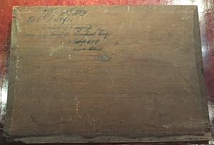
Folio (24 x 16 4/8 inches). Half-title, title-page with engraved vignette showing the first landing of Columbus in the New World, index, "Geographical Memoir," large folding engraved map of North America on 4 joined sheets, folding map of South America on 2 joined sheets, 16 further double-page engraved maps, all with original hand-colour in full (the folding maps strengthened on the verso at the folds, with some extensive worm tracks affecting the images, some light staining, one or two tears). Contemporary American blue morocco, each cover decorated with a broad border of blind and gilt tools, the spine in six compartments, gilt lettered in two, the others decorated with a gilt design (a bit scuffed). Preserved in the ORIGINAL WOODEN BOX IN WHICH THE ATLAS WAS SHIPPED TO ITS FIRST OWNER Provenance: the original wooden crated addressed to "Job Durfee, Member of Congress, to the care of Benj. B. Mumford Esq., Newport Rhode Island To be kept dry'' Originally shipped to Job Durfee (1790-1847) a politician and lawyer from Rhode Island, member of the Rhode Island House of Representatives (1816-1820) and member of the U.S. House of Representatives (1821-1825). The original crate, with each panel made from a single piece of pine. First edition, and "A LANDMARK IN AMERICAN CARTOGRAPHY. THE FIRST COMPREHENSIVE ANALYTICAL COMPILATION OF EXISTING CARTOGRAPHIC AND GEOGRAPHIC DATA FOR THE UNITED STATES AS A WHOLE" (Schwartz-Ehrenberg). Tanner's atlas includes maps of uniform size and scale of: The World; Europe; Asia; Africa; North America (4 sheets joined); South America (2 sheets joined); Maine, New Hampshire and other states; New York; Pennsylvania and New Jersey; Virginia, Maryland and Delaware; Ohio and Indiana; Kentucky and Tennessee; North and South Carolina; Georgia and Alabama; Louisiana and Mississippi; Illinois and Missouri; and Florida. "During the four-year period beginning in 1822, six large atlases were published in the United States by Carey and Lea, Fielding Lucas Jr., Sidney E. Morse, Henry S. Tanner, Anthony Finley, and J. Conrad. Lucas and Morse were located in Baltimore and New Haven, respectively; the other firms were situated in Philadelphia. "All six atlases represented solid cartographic workmanship, but the most remarkable was Henry S. Tanner's "New American Atlas", a landmark in American cartography. Walter Ristow, the foremost authority on U.S. commercial mapping, notes that the "Tanner atlas raised U.S. commercial map production to a new level of excellence". Borrowing Melish's plan, Tanner prepared an atlas of maps of uniform size and scale depicting individual states or state groups based on the latest available state and Federal maps. A map of the United States from coast to coast was also included which showed the four legendary rivers of the west, but with a qualifying statement doubting their existence. An accompanying memoir described in detail the source material used in the preparation of this work, which took 'nearly ten years of unremitted application and research". Tanner's "Atlas" represents the first comprehensive analytical compilation of existing cartographic and geographic data for the United States as a whole" (Schwartz-Ehrenberg, page 251). Henry Tanner was the younger brother of Benjamin Tanner, an established engraver who had trained with Peter Maverick, one of New York City's earliest engravers. Born in New York in 1786, Tanner served an apprenticeship with his older brother after moving to Philadelphia in 1810. "Tanner was a leading figure in establishing commercial map publishing in America and brought the atlas as a cartographic form to early maturity during the "golden age" of American copperplate printing. He combined the skills of a geographer with those of an editor and engraver to create authoritative maps during a period of unprecedented growth in topographical knowledge of North America. He represented the emergence in the world of American publishers of specialized maps, and. Seller Inventory # 72lib1400
Contact seller
Report this item
![]()


