
Order Total (1 Item Items):
Shipping Destination:

County Map State Illinois by Augustus Mitchell (16 results)
Skip to main search results
Search filters
Product Type
- All Product Types
- Books (11)
- Magazines & Periodicals (No further results match this refinement)
- Comics (No further results match this refinement)
- Sheet Music (No further results match this refinement)
- Art, Prints & Posters (1)
- Photographs (No further results match this refinement)
- Maps (4)
- Manuscripts & Paper Collectibles (No further results match this refinement)
Condition Learn more
- New (No further results match this refinement)
- As New, Fine or Near Fine (No further results match this refinement)
- Very Good or Good (2)
- Fair or Poor (No further results match this refinement)
- As Described (14)
Binding
- All Bindings
- Hardcover (No further results match this refinement)
- Softcover (No further results match this refinement)
Collectible Attributes
- First Edition (No further results match this refinement)
- Signed (No further results match this refinement)
- Dust Jacket (No further results match this refinement)
- Seller-Supplied Images (14)
- Not Print on Demand (16)
Language (1)
Price
- Any Price
- Under � 20 (No further results match this refinement)
- � 20 to � 40 (No further results match this refinement)
- Over � 40
Free Shipping
- Free Shipping to U.S.A. (No further results match this refinement)
Seller Location
Seller Rating
-

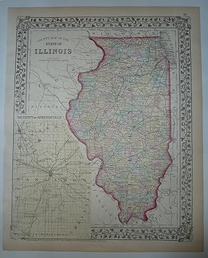
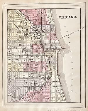
County Map of the State of Illinois with inset Plan of Chicago
Published by Mitchell, S. Augustus, Philadelphia, 1867
Map
10 3/4 x 13 1/4 inches. Condition: Very Good. Mitchell, S. A. (illustrator). This is a superbly colored map of Illinois and its counties designated with the use of two colors and no color for the third designator. The inset plan of Chicago is also designated with color by ward. Taken from an 1867 edition of Mitchells General Atlas it would look excellent framed an on the wall!
-
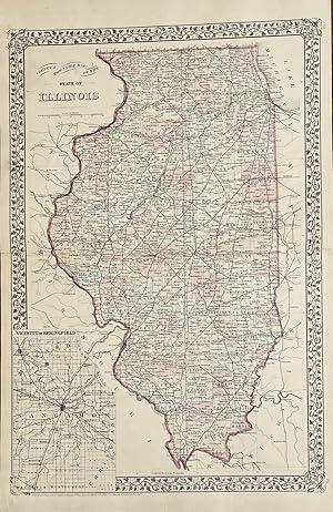
Map. Condition: Very Good. This hand-colored map with an inset of the city of Springfield and Sangamon County which is colored in light yellow. The state is outlined in red and the counties are colored in pastel green, yellow and rose. The map shows cities, towns and rail lines. From Mitchell's New General Atlas. Copyright date of 1874. A pretty map with floral border, suitable for framing. ; Hand-colored Map; 10.75 x 13.25".
-

County Map of the State of Illinois
Published by Philadelphia c.1865, Philadelphia, 1865
Seller: High Ridge Books, Inc. - ABAA, South Deerfield, MA, U.S.A.
Association Member: ABAA ESA ILAB SNEAB
Seller rating 5 out of 5 stars

Fully colored map of the State of Illinois, with a large inset Plan of Chicago. fine condition. No. 38. Decorative border. Full color by county on the state map, by ward on the Chicago plan. The copyright date on the map is 1861, but it is not clear which edition of Mitchell's General Atlas this is from.
-

"COUNTY MAP OF THE STATE OF ILLINOIS". 1861.
Seller: John K King Used & Rare Books, Detroit, MI, U.S.A.
Seller rating 4 out of 5 stars

15X12.5", hand-colored map with inset of "Plan of Chicago". Removed from atlas, margins darkened with couple small tape stain areas in top blank margin, would look handsome in frame.
-
County and Township Map of the State of Illinois Plan of Cincinnati and Vicinity
Published by Mitchell, S. Augustus, Philadelphia, 1879
Map
14 1/4 x 21 2=3/4 inches. Mitchell, S. Augustus (illustrator). 1879 edition. Contemporary-color highlights this double page map. The State of Illinois covers 400+ miles from North to South. This map show all the counties along with the townships within. A dramatic rr network is shown. The Illinois Central Railroad, Chicago and Alton Railroad and the Rock Island Railroad are accurately shown among the network.On the versos can be found a one page map of Cincinnati and Vicinity. It two has a well defined rr network. The Amin map has an inset of Central Illinois centered on Springfield. Very good with separations to the folds at the extremes repaired with archival mending tape.
-
County Map of The State of Illinois.
Published by Philadelphia,, 1867
Seller: libreria antiquaria perini Sas di Perini, Verona, VR, Italy
Seller rating 5 out of 5 stars
Art / Print / Poster
Incisione in acciaio, dipinta d'epoca a tutto campo, mm 290x355. Carta del territorio inquadrato entro bordura decorativa con vitigno intrecciato. Buon esemplare ben conservato, minime macchie marginali e numero "66" manoscritto coevo (annerito) all'ang. sup. destro.
-

County Map of the State of Illinois, 1872
Publication Date: 1872
Seller: Art Source International Inc., Boulder, CO, U.S.A.
Seller rating 5 out of 5 stars
his hand colored map was made for "Mitchells New General Atlas"published by S. Augustus Mitchell, Jr. in 1872. Illinois isillustrated. Counties, cities, railroads, rivers, and an inset map of the vicinity of Springfieldare illustrated and included. Distinctive ivy style border and pastel colors completethis fine map. This map measures 10.5 inches by 13.5 inches.
-

County and Township Map of the State of Illinois
Publication Date: 1887
Seller: Art Source International Inc., Boulder, CO, U.S.A.
Seller rating 5 out of 5 stars
This map was made by S. Augustus Mitchell for "Mitchells New General Atlas" published in 1887. The well maintained maps in this atlas feature Mitchell's characteristic pastel coloring and abundant details of geographical features. Illinois is illustrated on this map with an inset of the vicinity of Cook County. Details include the names of counties, important towns, rivers, lakes, and railroads. Counties are distinguished by color. These 1887 maps offer a fascinating perspective of areas that have since undergone significant growth and change, in addition to their value as great examples of Mitchell's work. This map measures 15 inches by 21.5 inches.
-

County Map of the State of Illinois
Publication Date: 1864
Seller: Art Source International Inc., Boulder, CO, U.S.A.
Seller rating 5 out of 5 stars
With characteristic floral boarders and beautiful, muted pastel coloring, these 1864 maps are fantastic examples of Mitchells work. Counties, important cities, mountain ranges, rivers, lakes, and railroads are identified. This hand colored map illustrates the state of Illinois with an inset showing the plan of Chicago. This map measures 10.75 inches by 13.5 inches.
-

County Map of the State of Illinois
Publication Date: 1870
Seller: Art Source International Inc., Boulder, CO, U.S.A.
Seller rating 5 out of 5 stars
S. Augustus Mitchell,Jr. made this hand colored map for Mitchells New General Atlas in 1870. This map illustrates Illinois. An inset shows the vicinity of Springfield at a greater scale. Counties are distinguished by bright pastel colors. Other details include the names of counties, important cities, railroads, proposed railroads, and major roads. This map measures 11 inches by 13.5 inches.
-

County Map of the State of Illinois
Publication Date: 1866
Seller: Art Source International Inc., Boulder, CO, U.S.A.
Seller rating 5 out of 5 stars
The Mitchell company was one of the first to try out the new technique of engraving on steel plates experimenting with steel almost 20 years before the rest of the publishing industry. He was printing with steel in the early 1830s; the general switch to steel was approximately 1850. During the early years of the company, Mitchell published mainly maps and travel guides. In 1860, Mitchell started producing "Mitchell's New General Atlas",and Mitchell Sr. retired and turned the business over to his sonof the same name. The New General Atlas was published until 1893. Today Mitchell maps are sought after for their fine engraving, bright coloring, and attention to detail. They are some of the finest maps produced during this time period. This map produced in 1866, has Mitchell's unique floral border, and beautiful hand coloring. This map details the state of Illinois with an inset map of Chicago. Counties, cities, towns, lakes, rivers, mountains, and transportation routes are noted. Each map was printed on thick paper with vibrant hand color. This map measures 10.5 inches by 13.5 inches.
-

County Map of the State of Illinois
Publication Date: 1868
Seller: Art Source International Inc., Boulder, CO, U.S.A.
Seller rating 5 out of 5 stars
This hand colored map was made for "Mitchells New General Atlas" published in 1868 by S. Augustus Mitchell, Jr. The state of Illinois is illustrated on this map. An inset shows the plan of the city of Chicago at a greater scale than the main map. Counties are distinguished by color. Other details include the names of counties and important cities, railroads, major roads,and rivers. The pastel coloring in this atlas is very beautiful and more muted than typical. This map measures 11 inches by 13.5 inches.
-

County &Township Map of the State of Illinois
Publication Date: 1881
Seller: Art Source International Inc., Boulder, CO, U.S.A.
Seller rating 5 out of 5 stars
This map came from Mitchells New General Atlas, 1881. This map shows major railroads, water bodies, and towns. Decorative ivy border, and nice colorful detail. Would look nice framed!' This map measures 14.5 inches by 21.5 inches.
-

County and Township map of the State of Illinois
Publication Date: 1885
Seller: Art Source International Inc., Boulder, CO, U.S.A.
Seller rating 5 out of 5 stars
This map was made by S. Augustus Mitchell for "Mitchells New General Atlas" published in 1885, by WM. M. Bradley & Co. The well maintained maps in this atlas feature Mitchell's characteristic pastel coloring and abundant details of geographical features. Details include the names of counties, cities, towns, transportation routes, rivers and lakes. These 1885 maps offer a fascinating perspective of areas that have since undergone significant growth and change, in addition to their value as great examples of Mitchell's work. This map measures 14.5 inches by 20.5 inches.
-
Chicago St Louis with a double page mat of Illinois on the verso. County & Township Map of the State of Illinois
Published by Hilton & Hughes in Atlas of the World, New York, 1885
Map
1885 Edition. This map was printed in color and came from an atlas most likely produced by the Bradley Firm that was successor to the Mitchell firm. Further it was apparently published for the firm of Hilton and Hughes whom are listed on the title page as publisher. The map of Chicago and also of St. Louis are pure Mitchell. The map of Illinois is a superb rarecord of the contemporary railroad networks. The map of Illinois is difficult to find in the marketplace and is from a rare late 19th century atlas. Very Good condition with several small tears repaired with archival mending tape Chicago, 10 3/4 x 13 1/2 : St. Louis, 10 3/4 x 14 1/2; Illinois, 14 x 20, with inset of Chicago and Vicinity of 8 1/2 x 6.
-

County Map of the State of Illinois
Publication Date: 1874
Seller: Art Source International Inc., Boulder, CO, U.S.A.
Seller rating 5 out of 5 stars
This map was produced by S. Augustus Mitchell in 1874 for his New General Atlas. This map shows Mitchell's traditional grape vine border, characteristic pastel coloring and abundant details of geographical features. The State of Illinois, and a large inset map of Springfield and vicinity are illustrated on this map. Counties are distinguished by color. These 1874 maps offer a fascinating perspective of areas that have since undergone significant growth and change, in addition to their value as great examples of Mitchell's work. This map measures 11 inches by 14 inches.
