
Order Total (1 Item Items):
Shipping Destination:

Asia by Society Diffusion Useful Knowledge (7 results)
Skip to main search results
Search filters
Product Type
- All Product Types
- Books (7)
- Magazines & Periodicals (No further results match this refinement)
- Comics (No further results match this refinement)
- Sheet Music (No further results match this refinement)
- Art, Prints & Posters (No further results match this refinement)
- Photographs (No further results match this refinement)
- Maps (No further results match this refinement)
- Manuscripts & Paper Collectibles (No further results match this refinement)
Condition Learn more
- New (No further results match this refinement)
- As New, Fine or Near Fine (No further results match this refinement)
- Very Good or Good (No further results match this refinement)
- Fair or Poor (No further results match this refinement)
- As Described (7)
Binding
- All Bindings
- Hardcover (No further results match this refinement)
- Softcover (No further results match this refinement)
Collectible Attributes
- First Edition (No further results match this refinement)
- Signed (No further results match this refinement)
- Dust Jacket (No further results match this refinement)
- Seller-Supplied Images (7)
- Not Print on Demand (7)
Language (1)
Price
- Any Price
- Under � 20 (No further results match this refinement)
- � 20 to � 40 (No further results match this refinement)
- Over � 40
Free Shipping
- Free Shipping to U.S.A. (No further results match this refinement)
Seller Location
Seller Rating
-
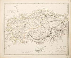
Asia Minor.
Published by London. c.1847, 1847
Seller: Peter Harrington. ABA/ ILAB., London, United Kingdom
Association Member: ABA ILAB PBFA
Seller rating 5 out of 5 stars

A pleasant, detailed map of Asia Minor, including Rhodes and Cyprus. Each separate region is named and in a differing outline colour. Published for the S.D.U.K. by Charles Knight. Size: 350 x 430 mm. Steel engraving with original outline colour. Good condition.
-

Turkey Containing the Provinces in Asia Minor
Publication Date: 1844
Seller: Art Source International Inc., Boulder, CO, U.S.A.
Seller rating 5 out of 5 stars
This finely detailed map was published in 1844 by the Society for the Diffusion of Useful Knowledge, a British philanthropical group. Cities, towns, regions, rivers and mountain ranges are illustrated. Copper plate engraved with original hand outline coloring. This map measures 16 inches by 12 inches.
-
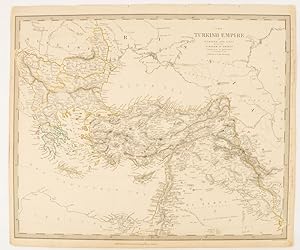
The Turkish Empire in Europe and Asia with the Kingdom of Greece.
Published by Charles Knight & Co. [circa1840s.], London., 1840
Seller: Asia Bookroom ANZAAB/ILAB, Canberra, ACT, Australia
Association Member: ANZAAB ILAB
Seller rating 5 out of 5 stars
Lithographed map with original outline hand-colour, 31.9 x 39.1 cm, small marginal tears neatly repaired with archival material, but no loss, small surface abrasion affecting the border at the foot, edgewear and browning, inked pagination in an early hand, but in very good condition. A handsome map with fine topographical engraving, also showing the borders with Hungary, Russia and Persia.
-

Asia Minor
Publication Date: 1844
Seller: Art Source International Inc., Boulder, CO, U.S.A.
Seller rating 5 out of 5 stars
This finely detailed map of Asia Minor was published in 1844 by the Society for the Diffusion of Useful Knowledge, a British philanthropical group. Cities, towns, regions, rivers and mountain ranges are illustrated. Copper plate engraved with original hand outline coloring. This map measures 16 inches by 12 inches.
-

Asia.
Published by London. c.1847, 1847
Seller: Peter Harrington. ABA/ ILAB., London, United Kingdom
Association Member: ABA ILAB PBFA
Seller rating 5 out of 5 stars
A pleasant and practical map of the continent of Asia, with each different country delineated in different outline colour. Top left corner has a table of countries and their populations at the time of publication. ublished by harles Knight for the S.D.U.K. Size: 350 x 430 mm. Steel engraving with original outline colour. Good condition.
-

Asia
Publication Date: 1844
Seller: Art Source International Inc., Boulder, CO, U.S.A.
Seller rating 5 out of 5 stars
This finely detailed map of Asia was published in 1844 by the Society for the Diffusion of Useful Knowledge, a British philanthropical group. Cities, towns, regions, rivers and mountain ranges are illustrated on this map. This map is copper plate engraved with original hand outline coloring. This map measures 15.5 inches by 12.25 inches.
-

The Turkish Empire in Europe and Asia With the Kindom of Greece
Publication Date: 1844
Seller: Art Source International Inc., Boulder, CO, U.S.A.
Seller rating 5 out of 5 stars
This finely detailed map was published in 1844 by the Society for the Diffusion of Useful Knowledge, a British philanthropical group. Cities, towns, regions, rivers and mountain ranges are illustrated. Copper plate engraved with original hand outline coloring. This map measures 15.5 inches by 12.5 inches.