Order Total (1 Item Items):
Shipping Destination:

Henry Hudson (Over 12,000 results)
Skip to main search results
Product Type
- All Product Types
- Books (12,329)
- Magazines & Periodicals (97)
- Comics (1)
- Sheet Music
- Art, Prints & Posters (140)
- Photographs (5)
- Maps (16)
-
Manuscripts &
Paper Collectibles (43)
Condition
Binding
Collectible Attributes
- First Edition (1,463)
- Signed (165)
- Dust Jacket (1,009)
- Seller-Supplied Images (5,004)
- Not Printed On Demand (9,550)
Free Shipping
Seller Location
Seller Rating
-
An exceptional pair of Blaeu Table Globes
Published by Amsterdam, Willem Jansz. Blaeu 1602 (published after 1621), 1602
Seller: Antiquariaat de Roo, Zwijndrecht, Netherlands
Seller Rating:

A very rare set of globes, 9 inch / 23cm, with an overall height of 38 cm, Amsterdam, dated 1602, but published after 1621. In their original stands with circular wooden horizon rings, covered with printed paper, supported by four legs and brass meridian rings supported by a single column. The terrestrial and celestial globes are made up of a set of 12 engraved gores, heightened in gold and Arctic ice caps, printed on paper and mounted on a plaster sphere of papier mach�. Each sphere is mounted in a graduated brass meridian ring, with the production number stamped on the back of the ring. The hour circles are renewed. Both globes are mounted on four-legged ebonized oak Dutch stands, which support the horizon ring. The legs are connected by two crossbeams, which support a circular base plate with central support for the meridian ring. The horizon rings are covered with printed paper. With usual defects: paper equinoctial tables present gaps that are filled and restored; small splits along gores; several partially deleted entries; on the globe, the date 1602 and the text of the cartouche in America, are illegible ; small scattered spots, but in general in good condition for such an early globe pair, of which presently only 19 pairs are recorded. These 9-inch globes are among the rarest since very few copies of them are known to exist, in comparison with the smaller or larger globes of Blaeu (4, 6, 13.5, and 26 inches). Blaeu's terrestrial globes were highly valued and were much in demand, because of the care with which they had been prepared, because of the efforts to give the latest information on discoveries, and because of the loxodromic lines that made them of special value to navigators. Willem Janszoon Blaeu (1571 1638) started "one of the most successful publishing houses of the seventeenth century" (Dekker). Originally trained in astronomy, he quickly became a leading maker of maps, atlases and instruments. At the time the Low Countries hosted the best cartographers in Europe, and Blaeu produced ever more accurate and more beautiful globes, spurred by his rivalry with fellow Dutch cartographer and publisher Jodocus Hondius. Blaeu s globes were luxury items for wealthy and intellectual merchants and nobility, who benefited from Blaeu s access through the Dutch East India Company to the latest navigational discoveries and geographical information. Willem Jansz Blaeu collected information that Dutch mariners gathered from around world and brought back to Amsterdam. Crews were instructed to record information about the lands they visited and the skies they saw. Blaeu incorporated these observations in maps and globes. Through his web of contacts and assiduous research, he was also able to obtain the most recent information about the latest discoveries in the western hemisphere and the South Pacific, where Dutch explorers were particularly active at the time. Since the globe was published after 1618, Blaeu was able to include the discoveries made by Henry Hudson in his attempt to find a passage to the East Indies. He also included recent Pacific discoveries of the celebrated voyages of Willem Cornelis Schouten and Jacob Le Maire, who both traversed the South Pacific and the Atlantic. The findings of Schouten and Le Maire in the Tierra del Fuego region are also incorporated. The Strait of Le Maire is drawn and the hypothetical southern continent is labeled "Terra Australis Incognita Magalanica". Olivier van Noort s track is drawn and labelled. His route is indicated with a broken line and the words: "Navigationis Olivierij ductus" (several times). There are various decorative features, such as animals on the different continents, many ships on the high seas and allegorical and mythical figures around the cartouches. The nine-inch globe is not just a smaller version of the one published in 1599. Drawings of animals and people do often correspond to those on the earlier globe, but Blaeu made several significant changes. The west coast of North America is drawn differently, and the river system of Brazil is altered. The hypothetical southern continent is labelled: Terra Australis Incognita Magallanica. There are nine ocean names in handsome curling letters: Mare Congelatum, Mare Atlanticum, Oceanus Aethiopicus, Mare Arabicum et Indicum, Mare di India, Oceanus Chinensis, Mar del Zur, Mare Pacificum, Mar del Nort. Willem Blaeu, always eager to display the latest discoveries, traced the route of Van Noort s route with a broken line. The findings of the voyage of Schouten and Le Maire in the Tierro del Fuego region are included, despite the 1602 date (names: Fr. Le Maire, Mauritius, Staten Landt, C.Hoorn, I.Barneveltij). Publication : According to Peter van der Krogt, the following states are known: Terrestrial, First state: 1602 (no known examples). Second state, c1618-1621 (no known examples). Third state: 1602, but c1621 (the present example). All the states are dated 1602 but the second state must have been published after 1618, since it includes the discoveries of Schouten and Le Maire (1615 1617), but not the name "Blaeu". Elly Dekker makes no distinction between the different states. The third state can be divided into states 3a and 3b. All globes have a different production number, some of which are illegible today. This terrestrial nine-inch globe is marked with "fabr. nr. 4". Celestial: First state: 1602 (known in a catalogue record but no known example surviving). Second state: presumably published after 1621. All 30 known celestial globes are in the second state, as is this one, which is marked with "fabr. no. 12". Rare: there are 19 recorded pairs, of which 14 are in institutions.Bibliography: Van der Krogt, Globi Neerlandici BLA III. Dekker GLB0152, GLB0083 (terrestrial) and GLB0151 (celestial).
-
[Pair of nine-inch table globes].
Published by 1602 [but c1621]., Amsterdam,, 1602
Seller: Daniel Crouch Rare Books Ltd, London, United Kingdom
Association Member: ABA ILAB PBFA
Seller Rating:

Manuscript / Paper Collectible
Amongst the rarest to survive Terrestrial and celestial globes, each with 12 hand-coloured engraved gores heightened in gold, with two polar calottes, over a papier m�ch� and plaster sphere, rotating on brass pinions within a brass meridian ring with graduated scale, and a graduated brass altitude quadrant, set into a seventeenth century Dutch wooden base with an engraved horizon ring, adumbrating scales, calendar, almanacs etc. With usual defects: paper equinoctial tables present gaps that are filled and restored, small splits along the gores, several partially deleted entries, small scattered spots but in general in good condition for such an early globe pair, modern hour circles and pointers. Biography Willem Janszoon Blaeu (1571-1638) started "one of the most successful publishing houses of the seventeenth century" (Dekker). Originally trained in astronomy, he quickly became a leading maker of maps, atlases and instruments. At the time the Low Countries hosted the best cartographers in Europe, and Blaeu produced ever more accurate and more beautiful globes, spurred by his rivalry with fellow Dutch cartographer and publisher Jodocus Hondius. Blaeu's globes were luxury items for wealthy and intellectual merchants and nobility who benefited from Blaeu's access through the Dutch East India Company to the latest navigational discoveries and geographical information. As van der Krogt observes, "During the preceding century, more than half of the known world, including the entire western hemisphere, had been charted and, more recently, during Blaeu's own time, large portions of the Pacific were being explored". Dutch explorers had played a key role in the expanding European worldview: from Olivier van der Noort's circumnavigation of the earth, to Willem Barentsz's attempts to find the Northeast Passage. Blaeu also had the advantage of considerable personal technical skill: he studied under the astronomer Tycho Brahe to create a star catalogue for his first celestial globe. Even at the time, Blaeu's globes were an expensive purchase: the terrestrial globe cost 16 guilders and the celestial globe cost nine guilders. However, it was also the most advanced cartographic document of the age: it was a monument and tool, to be used as much as admired. Blaeu's pair of nine-inch table globes are amongst the rarest to survive in comparison with the smaller or larger globes by Blaeu (four, six, 13.5, and 26 inches). Geography Willem Jansz Blaeu collected information that Dutch mariners gathered from around world and brought back to Amsterdam. Crews were instructed to record information about the lands they visited and the skies they saw. Blaeu incorporated these observations in maps and globes. Through his web of contacts and thanks to assiduous research, he was also able to obtain the most recent information about the latest discoveries in the western hemisphere and the South Pacific, where Dutch explorers were particularly active at the time. Since the globe was published after 1618, Blaeu was able to include the discoveries made by Henry Hudson in his attempt to find a passage to the East Indies. He also included recent Pacific discoveries of the celebrated voyages of Willem Cornelis Schouten and Jacob Le Maire, who both traversed the South Pacific and the Atlantic. The findings of Schouten and Le Maire in the Tierra del Fuego region are also incorporated. The Strait of Le Maire is drawn and the hypothetical southern continent is labelled "Terra Australis Incognita Magalanica". Olivier van Noort's track is drawn and labelled. His route is indicated with a broken line and the words: "Navigationis Olivierij ductus" (several times). There are various decorative features, such as animals on the different continents, many ships on the high seas and allegorical and mythical figures around the cartouches. The nine-inch globe is not just a smaller version of the one published in 1599. Drawings of animals and people do often correspond to those on the earlier globe, but Blaeu made several significant changes. - The west coast of North America is drawn differently and the river system of Brazil is altered. - The hypothetical southern continent is labelled: Terra Australis Incognita Magallanica. - There are nine ocean names in handsome curling letters: Mare Congelatum, Mare Atlanticum, Oceanus Aethiopicus, Mare Arabicum et Indicum, Mare di India, Oceanus Chinensis, Mar del Zur, Mare Pacificum, Mar del Nort. - Willem Blaeu, always eager to display the latest discoveries, traced the route of Van Noort's route with a broken line. The findings of the voyage of Schouten and Le Maire in the Tierro del Fuego region are included, despite the 1602 date (names: Fr. Le Maire, Mauritius, Staten Landt, C.Hoorn, I.Barneveltij). Astronomy The first maker of globes from the northern Netherlands was the cartographer Jacob Floris van Langren (before 1525-1610). He published his first terrestrial and celestial globes in 1586 with a diameter of 325mm, the terrestrial globes being based on the work of Mercator. The second edition of the celestial globe was improved after the observations of the southern hemisphere by Pieter Dirkz Keyser and Frederik de Houtman were incorporated by the geographer Petrus Plancius (1552- 1622), who was also influential as a globe maker. Two other famous Dutch mapmakers produced celestial globes: Jodocus Hondius the Elder (1563-1612), one of the most notable engravers of his day, and Willem Jansz Blaeu (1571-1638). Publication history According to Peter van der Krogt, the following states are known: Terrestrial First state: 1602 (no known examples). Second state, c1618-1621 (no known examples). Third state: 1602, but c1621 (the present example). All the states are dated 1602 but the second state must have been published after 1618, since it includes the discoveries of Schouten and Le Maire (1615-1617), but not the name "Blaeu". Elly Dekker makes no distinction between the different states. The third s.
-
Hardcover. Condition: Very good. First. THE BOBINS COPY of "THE MOST BEAUTIFUL COLOR PLATE BOOK PUBLISHED IN THE UNITED STATES IN THE NINETEENTH CENTURY." First edition. New York: Henry G. Megarey, 1821-1825. Oblong broadsheet folio (19" x 26", 482mm x 659mm). With 20 hand-colored aquatint-engraved plates by John Hill after William Wall (though see below), numbered 1-8, 10 210 12 15 13-14 215 16-20. Bound in modern half red-straight-grained morocco antique over (contemporary) marbled boards with the title ("VIEWS/ IN/ AMERICA") gilt to a red straight-grained morocco label on the front board. On the spine, seven gilt fillets. Lacking the letterpress text. Small repaired splits and tears throughout. Repaired tear (?) to the lower edge of no. 3 (View Near Jessups Landing). "View Near Fort Miller" (No. 10) printed in blue. "Troy from Mount Ida" (No. 12; see below) text weakly impressed, with marginal repair at the lower edge. Marginal repair to No. 15, with some skinning recto, not affecting the image. Fore-edge of No. 16 restored to about 1/4". Margins of No. 20 rebuilt, with the imprint filled in manuscript. A few marks of tanning and the odd spot of foxing, but altogether a rich set with good color. Drawing on the aesthetic category of the Picturesque -- a contrast to the Sublime that so much characterized image-making of the American West -- The Hudson River Port Folio depicts the spine of New York almost from its headwaters at Luzerne down through New York Harbor some 180 miles south. It is the vision of William Guy Wall (1792-1864), the grandfather of the Hudson River School (Thomas Cole's trip up the Hudson happened in the year the present work was completed). Born in Ireland -- cf. Finola O'Kane's 2013 Ireland and the Picturesque (Yale UP), which argues for the Irish origin of the British Picturesque -- Wall showed the early industrial Hudson Valley as a harmonious confluence of natural beauty and human endeavor. John Hill and his son John William Hill commercialized Wall's paintings after an aborted attempt by John Rubens Smith. This accounts in part for the odd numeration; nos. 2, 3, 5 and 11 (here numbered 12) were reworked compositions of Smith's. As with so many ambitious illustrated publications, the work was issued in parts of 4 plates; the initial goal had been 24 plates in 6 numbers but the final number never made it to press. No title-page was ever issued, and numeration is inconsistent (e.g., in the Metropolitan Museum set "Troy from Mount Ida" is numbered 11). I have seen no mention of a blue run for "View Near Fort Miller;" is it perhaps a proof plate? Examples of the portfolio with all plates in the original state -- the whole portfolio was reissued in 1828 by the Carvills, with their names added -- are rare indeed (it receives Howes's second-highest scarcity rating of "d"). The Reese copy sold in 2022 ($201,600) and the present copy at the Bobins sale in 2023; before those Christie's confirms that no complete set of the first-edition plates had come to auction since 1948. Norman Bobins began his vast collection of color-plate books in the early 1980's -- many having been purchased at Arader -- and began to disburse them in a series of landmark sales at Christie's. The present item was lot 80 in part 1 (16 June 2023). De�k 320; Howes W 47; Koke, Checklist 73-94; Reese, Color Plate Books 6.
-
Voyage dans l'Am�rique septentrionale, ou Description des pays arros�s par le Mississippi, l'Ohio, le Missouri et autres rivi�res affluentes.
Published by Paris: Arthus Bertrand, 1826 [but printed in 1804-1805]., 1826
Book First Edition Signed
Hardcover. Condition: Very Good. 1st Edition. 3 volumes. 2 text volumes: 8vo (8 x 5 inches). Half-titles. Half tan calf, marbled boards, gilt (extremities rubbed); preserved in brown morocco backed slipcase and chemise. Atlas: Folio (15 x 12 inches). 4 letterpress leaves including the title-page and plate list in French and English. 11 fine folding engraved maps, 14 engraved plans, and 11 engraved plates (8 views, 3 figures of native Americans), all engraved by Tardieu (folding maps with some very mild offsetting, North America map with slight fold tear, paper flaw to Part II of Ohio River map with small loss to blank area, guards renewed, very mild occasional foxing or marginal spotting, text leaves toned). Contemporary half vellum, marbled paper boards uniform with text volumes, citron and red morocco lettering-pieces on the spine (extremities rubbed). Provenance: John B. Stetson, his sale Parke-Bernet, 14 April 1953, lot 207; sold by Henry Stevens in 1953 to Frank T. Siebert; text volumes purchased by Siebert from Maggs Bros., his sale, Sotheby's New York, Oct 28, 1999, lot 819; with the signed bookplate of Bruce McKinney loosely inserted, his sale 2nd December 2010, lot 150 A PARTICULARLY FINE AND ATTRACTIVE COPY WITH A SUPERB PROVENANCE of the first edition, in French, with the RARE atlas volume which accompanies Collot's account of his extensive survey of the Louisiana region, including his celebrated map on three sheets of the Ohio River. "The beautifully executed map of the Ohio River [on three sheets] depicts vividly the wilderness that this country was at the time of his journey" (Wagner-Camp). The other remarkable maps include a general map of North America; the course of the Ohio from its source to its junction with the Mississippi; the road from Limestone to Frankfort in Kentucky; a stretch of a branch of the river Juniata; a map of the course of the Mississippi from the Missouri to its mouth; a map of Illinois country; a map of the Missouri and of the higher parts of the Mississippi and the plain where the waters divide to run north-east to Hudson's Bay, north-north-west to the Frozen Sea, and south into the gulf of Mexico, and showing Mackenzie's route of 1789; a chart of the sources of the Mobile and of the Yazoo. Fine plans of most important forts are included: Erie, Niagara, Natchez, New Madrid or Anse a la Graisse, and Baton-Rouge. As are plans of the towns of Pittsburgh, St.-Louis, and a sketch of New Orleans. Collot, who served under Rochambeau during the Revolutionary War, was commissioned to make a reconnaissance of the Mississippi valley by Pierre Auguste Adet (1763-1834), French ambassador to the United States. He was to report of the political, economic and military situation in the region, which was under Spanish control, in anticipation of the reacquisition of Louisiana by France from Spain. But as a result of the Louisiana Purchase, however, the "work was printed, both in French . and English, but not published, at the time of Gen. Collot's death, which happened in 1805. More than twenty years afterwards, the whole impression came into the hands of M. Bertrand, an eminent publisher in Paris, who reserved 100 copies of the English and 300 of the French edition, and made waste paper of the remainder" (Rich, Bibliotheca Americana Nova, 2: p. 185). Howes C-601; Sabin 14460; Wagner-Camp 31a. Catalogued by Kate Hunter. Signed by Author(s).
-

Purchas his Pilgrimes. In five bookes. - Purchase his Pilgrimage.
Published by London: William Stansby for Henrie Fetherstone, 1625 - 1626., 1626
First Edition
Together, 5 volumes. Folio (13 x 8 1/8 inches). Additional engraved title-page (re-margined at foot), FINE double-page folding engraved map of "Virginia" by John Smith (21 4/8 x 16 inches to the neatline, 13 6/8 x 17 2/8 inches sheet size), AN EARLY STATE PRECEDING THAT INTENDED FOR PUBLICATION WITH PURCHAS: Church state 4, Burden state 6, with UNUSUALLY WIDE MARGINS SHOWING THE PLATE-MARK (an early repair to verso at the bottom of the centerfold, small hole at the fold, and one or two other separations along the horizontal fold, one or two spots), 6 double-page maps, including "Hondius his Map of the Christian World", 81 maps in the text, engraved and woodcut illustrations, head- and tail-pieces and initials (without 4 leaves: blanks vol. 1 1, vol. 3 [pi]1, and vol. 4 1, and colophon vol. 2 2e4; approximately 30 leaves with small marginal tissue strengthening, approximately 25 leaves with marginal areas renewed, 2 brief marginal worm trails repaired, 2 final leaves repaired affecting a few letters, New England/Canada and Virginia maps strengthened on verso and with short separations, 2 inset maps shaved at fore-edge, a third with hole repaired affecting a few words on verso). Late 19th-century pebble-grained morocco gilt by J. Clarke of Bedford, gilt dentelles (bindings lightly rubbed). Provenance: George Smith, his sale Sotheby's July 1867, lot 6479; John Dunn-Gardner (1811-1903), MP and extensive landowner in Cambridgeshire, England, with his pencilled notes re provenance at the end of volume one; his sale, London, 1854, sold for �75; with the engraved armorial bookplate of Sir Edward Sullivan (1822-1885), who describes this copy in a manuscript note tipped-in at the end: "perhaps the finest extant.it is quite perfect. the Royal Arms were on the old calf covers", his sale, London, June 6, 1890, lot 5146. "One of the fullest and most important collections of early voyages and travels in the English language" (Sabin) First edition of Purchas his "Pilgrimes." and fourth edition of the "Pilgrimage.", issued simultaneously as a supplement. Early issue of "Pilgrimes" with "Hondius his Map of the Christian World" in volume one, pages 65 and 115, 2T6 incorrectly numbered, and the headline on page 704 reading "Hollanders lying devices," but with second issue of engraved title-page, an unusually complete copy, the only significant absence being the colophon to volume 2, which is frequently missing. Second issue of the "Pilgrimage." with dedication to King Charles. Material relating to America begins in book III, about halfway through volume III with an account of George Barkley's travels, accompanied by a map of the arctic regions "Polus Arcticus." . Book IV entitled "English Northerne Navigations, and Discoveries, Relations of Greeneland, Groenland, The North-West Passage, and other Arctike Regions, with later Russian Occurrents" is illustrated with Henry Briggs's double-page map of "The North part of America." This map is best known for being the progenitor of the myth of California as an island, but since it may have been published as early as 1622 it is also proposed as the first map to name "Hudsons bay", "Fretum Hudson", "Hudsons R", "Cape Cod", and "De la war bay" (Burden 314). Book V concerns the "Voyages, and Travels to and in the New World, called America: relations of their Pagan Antiquities and of the regions and plantations in the North and South parts thereof, and of the Seas and Islands adiacent". It is illustrated with "Hondius his Map Of America", "Hondius his Map of Hispaniola, Cuba, &c", "Hondius his Map of Florida", "Hondius his Map of New Spaine", "Hondius his Map of America Meridionalis", "Hondius his Map of the Magellan Streight", and numerous woodcuts of Mexican art and hieroglyphics. The fourth volume, containing books VI to X includes many famous accounts of voyages of exploration to and in the New World, and is famously illustrated with JOHN SMITH'S MAP OF "VIRGINIA", IN AN EARLY STATE PRECEDING THAT INTEN.
-
The Small Voyages, Parts I-XI, in Latin.
Published by Frankfurt & Oppenheim: Erasmus Kempffer [and many others], 1601-33, 1601
Seller: Peter Harrington. ABA/ ILAB., London, United Kingdom
Association Member: ABA ILAB PBFA
Seller Rating:
First Edition
First or second Latin editions; an unusually substantial set of the Small Voyages, one of the most magnificent voyage anthologies published in the Age of Discovery. The greatest single collection of early voyages to the East Indies, it also holds a wealth of cartographical and visual material on Africa, India, America, South Asia, and the Middle East, including the first Latin translation of Gasparo Balbi's travelogue, Viaggio dell' Indie Orientali. Within the genre of cosmographic literature, the beautiful engravings are the most distinctive feature of the Small Voyages. In contrast to Ramusio's Navigationi et Viaggi, Hakluyt's Principall Navigations, and Thevet's Cosmographie Universelle, "the size, number, and quality of the engravings in the De Bry volumes were unprecedented Almost overnight the collection became indispensable for Europeans who wanted to have a state-of-the-art iconography of the overseas world" (Groesen, p. 46). Its cartographic accuracy remained unsurpassed for almost a century. Part VII includes the Middle East travelogue of Gasparo Balbi (1550-1623), Venetian state jeweller and merchant, "the first writer to record the place names between al-Qatif and Oman that are still in use today" (King, p. 74). This constitutes the earliest printed source for the place names along the coast of the UAE, Qatar, and Oman. It was first published in 1590 as Viaggio dell' Indie Orientali, making this the second time it appeared in print and the first Latin translation. Balbi's account contains much information for merchants, including rates of exchange duties, travel routes, distances, and pearling grounds. The first Dutch trading expedition to the East Indies from 1595 to 1597, led by Cornelius de Houtman, comprises part III. In the last quarter of the 16th century, the Portuguese Crown faced a growing range of problems in its trade. This gave the Dutch a strong incentive to challenge the Portuguese monopoly of the Cape route and to participate directly, Houtman's being the earliest attempt. The comprehensive map, Descriptio Hydrographica accommodata ad Battavorum navigatione in Javam insulam Indiae orien (first published in 1599), shows Houtman's route and includes the Arabian Peninsula in its entirety with numerous places identified along the coast. Part X contains Henry Hudson's voyage in search of the north-west Passage, with an adapted version of the first map depicting Hudson Bay. His crew set sail in 1610 in Discovery, and after reaching Greenland, they worked their way into a spacious sea - Hudson Bay. Heading south along the eastern shore, they wintered at the southernmost point at James Bay, noted on the lower left of the map. The ship was abandoned and only eight men made it back to England alive. Hudson Bay is dubbed "Mare Magnum" on the map, as Hudson believed he had reached the Pacific Ocean. The map first appeared in Hessel Gerritsz's account Beschryvinghe van der Samoyeden landt in Tatarien (1612). At this time an awareness of the wider world began to sift through to more educated circles. "Efforts to systematically compile all available knowledge in various fields dominated scholarly activities during the 'Age of Curiosity'. Sandwiched between the eras when first theology and later science dictated the intellectual agenda, early modern curiosity was characterised by a period of discovery and wonder followed by an erudite pleasure in classification and order" (Groesen, p. 29). The encyclopaedic tradition becomes evident in De Bry's assembly of travel accounts. De Bry's two major collections are can be divided into the Great Voyages, looking west and focusing on America and so called because of their larger folio size, and the Small Voyages looking east, focussing on the East Indies. They appeared first under the editorship of Theodor de Bry. After his death in 1598 it was taken over by his sons Johann Israel and Johann Theodor. This set is a mix of first and second Latin editions. Many of the maps and plates are highly prized individually, which has contributed to copies being disassembled, and consequently copies are often found lacking maps or plates. The bibliographical understanding of this work is still unfolding, thus discrepancies within references are often found. The second and third editions have "endless variations of texts and illustrations. It formed a bibliographical puzzle of the utmost complexity" (Rylands, p. 189). In this set, the maps of Africa are lacking from part I, the plan of Goa from part II, the plan of St. Helena in part III, plate IV in part IV, and plate III in part IX. The set also lacks part XII and the appendix to part I, both difficult to obtain. THE PARTS Part I. Vera Descriptio Regni Africani, quod tam ab Incolis quam Lusitanis Congus appellatur, 1624. Second edition. 14 engraved plates. Here without the 2 folding engraved maps of Africa (which Crawford counts as one) and the map of the Congo. The first part contains the visit of Odoardo Lopez, a Portuguese, to the Congo in 1578. "It was written by Filippo Pigafetta, from the dictation of Lopez, and was published at Rome in 1591. The Latin translation, here used, is the work of Cassidore de Reyna" (Church 206), which is one of the most important early descriptions of central Africa. Part II. II Pars Indiae Orientalis, 1628. Second edition. Engraved plate of coins (bound in part III), 2 maps - Nova Tabula Insularum Iavae and Insulae et arcis Mocambique (bound in part III and IX), 37 in-text illustrations, and an engraved portrait in the text. In the first edition, the 37 illustrations were published as plates. This part contains the voyages of Jan Huygen van Linschoten to the East Indies from 1583 to 1592. The account was first published in the Netherlands in 1596 and translated into German and Latin by the De Bry workshop. Part III. Tertia Pars Indiae Orientalis, 1629. Second edition. 58 engraved plates and 4 engraved maps. The large folding plan of Agra, often missing, is pres.
-
[Terrestrial globe]. In ista quam exhibemus Terreni Globi descriptione omnium regionum juxta et insularum .
Published by Mattaeus Greuter, 1632
Seller: Bruce Marshall Rare Books, Cheltenham, United Kingdom
Seller Rating:
Map
No Binding. Condition: Fine. [Rome], Mattaeus Greuter, 1632. Large engraved terrestrial globe (49 cm diameter) on a brass spindle and ebony-stained wooden base, with 2 sets of 12 half-gores running from 80&730;N to 80&730;S and 2 polar callottes over a plaster-covered papier m�ch� sphere, unstained wooden horizon and meridian rings, both covered with manuscript paper rings. There are 4 cartouches with arms, figures and navigational instruments (and a depiction of the globe itself); 4 compass roses; two mythological figures and a sea monster; and numerous ships. Partly coloured in outline by a contemporary hand. One of the largest and most accurate terrestrial globes produced before 1650, serving to launch Greuter's short career as Italy's leading globe maker. Though mostly based on Blaeu's largest globe (state 1c of c.1618 or state 2 of 1622), it is more than just a copy. Greuter gives a much more detailed and more accurate depiction of Tierra del Fuego and also reflects the 1624 establishment of a Dutch colony in the present-day New England by labelling it "Nieu Nederland." Not intending his globe as a navigational instrument, he also omitted Blaeu's rhumb lines. Lake Ontario is depicted fairly well, but the other Great Lakes are merged into one enormous body. The Solomon Islands and The Solomon Islands and northern coast of New Guinea, explored by Jacob Le Maire and Willem Schouten in 1616, are depicted (as is "Willem Schouten Eylandt"). Like Blaeu's globe, it indicates the hypothetical coast of the still elusive Antarctica (the ephemeral Dutch sightings of Australia were not to solidify for another decade, but Antarctica shows a northward extension approximately in its place). In the Pacific, a sea god riding on a spouting whale plays a lyre, while a nearby mermaid blows a shell trumpet. The cartouche around the note to the reader (the text used as the "title" in the present description) is flanked by a man with a spade and woman with a whip, together holding an armillary sphere. That around the note on the determination of longitude is flanked by two Ottomans, one with a quadrant and the other with a cross-staff. They both look up at an image of the globe itself, in its four-legged stand. These two cartouches are mirror image copies of Blaeu's, and the texts are based on Blaeu's (the former slightly revised and latter abbreviated in the middle). The scrollwork cartouches around the note on discoveries and around Greuter's new dedication (to Count Jacobo Boncompagni of Aquino) are new, the former with garlands of fruit and the latter topped by the dedicatee's arms. The text of the former is partly based on Blaeu's, but rearranged and with additions and omissions (Greuter's reference to "Cathai� et China" is new; both note Henry Hudson's discoveries). The paper on the horizon ring is drawn and lettered in manuscript, as usual. Although smaller than Blaeu's globe (68 cm), Greuter's is nearly as large as Van Langren's (1589) and Hondius's (1613), and larger than any other globe produced in the Netherlands at the time. Blaeu produced his globe in 1617, but revised it soon after to include Le Maire's new discoveries in Tierra del Fuego and New Guinea. He rendered Tierra del Fuego in three different forms, the last in the globes issued c.1618 and later. While Greuter clearly copied most of Blaeu's globe, he renders Tierra del Fuego more accurately than any of the three Blaeu versions. The closest possible model is Hondius's 1629 map (Koeman & V.d. Krogt II, p. 604, map 9950:2A.1, with a small illustration).
-
Sketches in North America and the Oregon Territory. By Captain H. Warre, (A.D.C. to the late Commander of the Forces)
Published by Dickinson & Co, [London], 1848
Seller: Donald A. Heald Rare Books (ABAA), New York, NY, U.S.A.
Seller Rating:
First Edition
Folio. (21 x 14 1/4 inches). Letterpress title (verso blank), pp.[1-]5 letterpress text Sketch of the Journey. 20 hand-coloured lithographed views on 16 sheets, by Dickinson and Co., after Warre, 1 lithographic map, hand-coloured in outline with routes marked in red and blue. Very minor foxing to a few plates. Contemporary purple cloth, rebacked and retipped with dark purple morocco, spine with raised bands in seven compartments, ruled in gilt and blind on either side of each band, lettered in gilt in the second compartment Provenance: William Rathbone (booklabel); Lester E. Bauer (Parke-Bernet, 3 December 1958, lot 508); Frank T. Siebert (Sotheby's New York, 28 October 1999, lot 860) First edition, original hand-coloured issue of a work which contains the "only western color plates comparable in beauty to those by Bodmer" (Howes). An important record of the American west before it was touched by western civilization. Captain Warre and Lieutenant Mervin Vavasour, of the Royal Engineers, left Montreal on 5 May 1845. They initially accompanied Sir George Simpson, governor of the Hudson's Bay Company, who was making a tour of inspection of the Company's outposts. On reaching Fort Garry (plate 1) at the confluence of the Red and Assiniboine Rivers, they teamed up with Peter Skene Ogden (1790-1854), a Company Chief Trader who had vast experience of the West, the Columbia and the Rockies in particular. Travelling mainly on horseback, the journey from the fort over the Rockies to Fort Colville took them from 16 June to 12 August. This section of the journey is illustrated by five plates. They left Fort Colville in boats and made their way down the Columbia River arriving at the Pacific on 25 August (3 plates). They then spent the winter exploring Oregon Territory and the Pacific Coast, visiting the Company settlement on the Willamette River (2 plates), exploring the Columbia River (1 plate), visiting Fort George on the Columbia River (2 plates), Vancouver Island and Fort Vancouver (1 plate), Cowelitz River and Puget's Sound. Once the weather started to improve, Warre and Vavasour and a party of about 30 began their westward journey on 25 March 1846, again by boat, but this time against the current. Warre made sketches of Mount Hood (2 plates) during this journey. They arrived at Fort Walla Walla, a distance of about 200 miles, on 3 April. They then took to horses again, and taking a short cut of about 250 miles, made for Fort Colville across a desert landscape (1 plate). From Fort Colville they went up the Columbia by boat for about 250 miles, setting off to cross the Rockies on foot. After seven days their food ran out, but, fortunately, a search party sent out from the Company station at Jasper's House found them and guided them to safety. The station was on the Atthabasca River, and from here they again took to boats and swiftly descended a distance of nearly 400 miles in two and half days to Fort Assinboine. On horseback, they travelled 100 miles in three days to Fort Edmonton on the Saskatchawan River. Then, by boat, 500 miles down the river to Fort Carlton. Again on horseback, they crossed the prairie to Red River in ten days, a distance of about 450 miles, arriving back at Fort Garry on 7 June. Here they met up with Sir George Simpson and together returned by boat to Montreal, arriving on 20 July 1846. The background to the journey was semi-official and semi-secret: Warre and Vavasour were to make what amounted to a military reconnaissance of the Oregon Territory. American expansionists were making it clear that the uneasy joint occupation of Oregon by the United States and Great Britain was not equitable and were demanding that a northernmost frontier be established. The two officers, with the enthusiastic support of the Hudson's Bay Company, were sent to gather information that would be of use in the negotiations. As Howes notes, Warre's dramatic depiction of the scenery, situations and incidents he encountered has resulted in "the only western color plates comparable in beauty to those by Bodmer." This copy without the dedication to the Hudson's Bay Company executives, which, as Howes notes was not issued in all copies. Warre continued with his military career after his return to Great Britain, serving with distinction in both the Crimean and the New Zealand Maori wars, he was knighted for his military services and retired with the rank of General. In addition to the present work he also published a series of views in the Crimea, published in London in 1856, but the present work is his undoubted masterpiece. Abbey Travel II, 656; Graff 4543; Howes W-114; Sabin 101455; Smith 10727; Wagner-Camp 157.
-
Sketches in North America and the Oregon Territory. By Captain H. Warre, (A.D.C. to the late Commander of the Forces)
Published by Dickinson & Co, [London], 1848
Seller: Donald A. Heald Rare Books (ABAA), New York, NY, U.S.A.
Seller Rating:
First Edition
Folio. (20 1/4 x 14 inches). Letterpress title (verso blank), pp.[1-]5 letterpress text Sketch of the Journey. 20 hand-coloured lithographed views on 16 sheets, by Dickinson and Co., after Warre, 1 lithographic map, hand-coloured in outline with routes marked in red and blue. Contemporary red half morocco gilt, rebacked preserving original spine. First edition, original hand-coloured issue with rare dedication leaf of a work which contains the "only western color plates comparable in beauty to those by Bodmer" (Howes). An important record of the American west before it was touched by western civilization. Captain Warre and Lieutenant Mervin Vavasour, of the Royal Engineers, left Montreal on 5 May 1845. They initially accompanied Sir George Simpson, governor of the Hudson's Bay Company, who was making a tour of inspection of the Company's outposts. On reaching Fort Garry (plate 1) at the confluence of the Red and Assiniboine Rivers, they teamed up with Peter Skene Ogden (1790-1854), a Company Chief Trader who had vast experience of the West, the Columbia and the Rockies in particular. Travelling mainly on horseback, the journey from the fort over the Rockies to Fort Colville took them from 16 June to 12 August. This section of the journey is illustrated by five plates. They left Fort Colville in boats and made their way down the Columbia River arriving at the Pacific on 25 August (3 plates). They then spent the winter exploring Oregon Territory and the Pacific Coast, visiting the Company settlement on the Willamette River (2 plates), exploring the Columbia River (1 plate), visiting Fort George on the Columbia River (2 plates), Vancouver Island and Fort Vancouver (1 plate), Cowelitz River and Puget's Sound. Once the weather started to improve, Warre and Vavasour and a party of about 30 began their westward journey on 25 March 1846, again by boat, but this time against the current. Warre made sketches of Mount Hood (2 plates) during this journey. They arrived at Fort Walla Walla, a distance of about 200 miles, on 3 April. They then took to horses again, and taking a short cut of about 250 miles, made for Fort Colville across a desert landscape (1 plate). From Fort Colville they went up the Columbia by boat for about 250 miles, setting off to cross the Rockies on foot. After seven days their food ran out, but, fortunately, a search party sent out from the Company station at Jasper's House found them and guided them to safety. The station was on the Atthabasca River, and from here they again took to boats and swiftly descended a distance of nearly 400 miles in two and half days to Fort Assinboine. On horseback, they travelled 100 miles in three days to Fort Edmonton on the Saskatchawan River. Then, by boat, 500 miles down the river to Fort Carlton. Again on horseback, they crossed the prairie to Red River in ten days, a distance of about 450 miles, arriving back at Fort Garry on 7 June. Here they met up with Sir George Simpson and together returned by boat to Montreal, arriving on 20 July 1846. The background to the journey was semi-official and semi-secret: Warre and Vavasour were to make what amounted to a military reconnaissance of the Oregon Territory. American expansionists were making it clear that the uneasy joint occupation of Oregon by the United States and Great Britain was not equitable and were demanding that a northernmost frontier be established. The two officers, with the enthusiastic support of the Hudson's Bay Company, were sent to gather information that would be of use in the negotiations. As Howes notes, Warre's dramatic depiction of the scenery, situations and incidents he encountered has resulted in "the only western color plates comparable in beauty to those by Bodmer." This copy includes the rare dedication to the Hudson's Bay Company executives, which, as Howes notes was not issued in all copies. Warre continued with his military career after his return to Great Britain, serving with distinction in both the Crimea.
-
Sketches in North America and the Oregon Territory.
Published by [London:] Dickinson & Co., [1848.], 1848
Book First Edition
Soft cover. Condition: Very Good. 1st Edition. Broadsheet (21 4/8 x 14 4/8 inches). Publisher's slip advertising binding options tipped-in to first text leaf (without the dedication leaf found in some copies). Lithographed map and 20 FINE tinted lithographed views after Warre on 16 sheets (wear with small losses in margins of text leaves and some guards, some of these with small, old repairs, plates with light wear and light spotting near blank edges, one plate with short marginal tears). Original cloth-backed printed paper wrappers (gutta percha perished leaving all leaves loose, front wrapper chipped and with repaired tear near spine, finger-sized loss to rear wrapper, some soiling) in blue modern clamshell box. Provenance: with the ownership inscription of ?'S.R.G.' on the front wrapper. FIRST EDITION, IN THE ORIGINAL WRAPPERS, OF THIS MAGNIFICENT SERIES OF PACIFIC NORTHWEST VIEWS, including dramatic images of Puget Sound, Mount Hood, and multiple views of the Columbia River and of the Rocky Mountains, most peopled with small figures of Native Americans in the foreground. A few scenes, such as the view of Fort Vancouver, depicted on the same plate with the scene of an "Indian tomb" (a canoe about to be launched on its final voyage), delicately evoke the poignancy of colonization. These are some of the earliest and most beautiful lithographed views of the Rockies and Pacific Northwest. The Oregon country had been "jointly occupied by American and English settlers since 1818; by the 1840s both nations looked to annex the territory to gain an outlet to the Pacific. Spurred by the interests of the Hudson's Bay Company, the British viewed the Columbia River as the appropriate boundary between Canada and northwest America. Expansionists in the United States looked much further north and coined the latitudinal slogan "54�40' or Fight!" In 1845, in anticipation that war might break out in Oregon, Captain Henry James Warre was sent out of Montreal in secret to survey the region. As a British officer, Warre had been trained to sketch the landscape; during the arduous fourteen-month journey by canoe, boat, and horseback, he made more than eighty drawings. By 1846 the crisis was settled by the Oregon Treaty, which fixed the boundary at the 49th parallel. Warre then converted his sketches and notes into a magnificent color plate book, the most important one published on the subject of the Pacific Northwest" (Virginia Historical Society online). Abbey, Travel 656; Graff 4543; Howes W-114 ('the only western color-plates comparable in beauty to those by Bodmer'); Sabin 101455; Smith 10727; Wagner-Camp-Becker 157. Catalogued by Kate Hunter.
-
Purchas his Pilgrimes. In five bookes. - Purchase his Pilgrimage.
Published by London: William Stansby for Henrie Fetherstone, 1625 - 1626., 1626
First Edition
Together, 5 volumes. Folio (13 x 8 2/8 inches). Additional engraved title-page, FINE double-page engraved map of "Virginia" by John Smith (13 x 14 2/8 inches, close cropped along the lower and right edges into the plate-mark), Burden 164 state 10, 7 double-page maps (map of China repeated), including "Hondius his Map of the Christian World", 81 engraved vignette maps in the text, 7 engraved vignettes in the text and woodcut illustrations throughout, head- and tail-pieces and initials (without initial blanks, 2 text leaves with short tears). Modern fine binding of mottled brown morocco by Trevor Lloyd, the covers ruled in blind, the spines in six compartments with five rasied bands, red morocco lettering-pieces in one, the others decorated with fine gilt tools. Provenance: 19th-century pencilled annotations to margins throughout. "One of the fullest and most important collections of early voyages and travels in the English language" (Sabin) First edition of Purchas his "Pilgrimes." and fourth edition of the "Pilgrimage.", issued simultaneously as a supplement. This issue of "Pilgrimes" with "Hondius his Map of the Christian World" in volume one on page 115 only, 2T6 incorrectly numbered, the headline on page 704 reading "Hollanders lying devices, to disgrace the English", with the colophon to volume 2, which is frequently missing, but with second issue of engraved title-page. Second issue of the "Pilgrimage." with dedication to King Charles. Material relating to America begins in book III, about halfway through volume III with an account of George Barkley's travels, accompanied by a map of the arctic regions "Polus Arcticus." . Book IV entitled "English Northerne Navigations, and Discoveries, Relations of Greeneland, Groenland, The North-West Passage, and other Arctike Regions, with later Russian Occurrents" is illustrated with Henry Briggs's double-page map of "The North part of America." This map is best known for being the progenitor of the myth of California as an island, but since it may have been published as early as 1622 it is also proposed as the first map to name "Hudsons bay", "Fretum Hudson", "Hudsons R", "Cape Cod", and "De la war bay" (Burden 314). Book V concerns the "Voyages, and Travels to and in the New World, called America: relations of their Pagan Antiquities and of the regions and plantations in the North and South parts thereof, and of the Seas and Islands adiacent". It is illustrated with "Hondius his Map Of America", "Hondius his Map of Hispaniola, Cuba, &c", "Hondius his Map of Florida", "Hondius his Map of New Spaine", "Hondius his Map of America Meridionalis", "Hondius his Map of the Magellan Streight", and numerous woodcuts of Mexican art and hieroglyphics. The fourth volume, containing books VI to X includes many famous accounts of voyages of exploration to and in the New World, and is famously illustrated with JOHN SMITH'S MAP OF "VIRGINIA". John Smith's map of "Virginia" "one of the most important printed maps of America ever produced and certainly one of the greatest influence. It became the prototype for the area for half a century until Augustine Herman's map of 1673. First issued separately in London, it accompanied many editions of various publications for another twenty years. It, therefore, was seen widely and inspired much interest in the fledgling Virginia colony, influencing considerably its eventual success. Consequently the east coast of North America became dominated by the English. To this day the map is still used by archeologists to locate native India villages. It records 166 of them" (Burden 164). Also featured is Sir William Alexander, Earl of Stirling's map of New France, New Scotlande and New Englande (Burden 208). First published in 1624 to accompany his "An Encouragement to Colonies", this is an important map as it records the twenty names of patentees granted land between 40 and 48 degrees north latitude, stretching from the Atlantic to the Pacific Ocean, and including the.
-
A Dictionary of the English Language: in which The Words are deduced from their Originals, and Illustrated in their Different Significations by Examples from the best Writers. To which are prefixed, A History of the Language, and An English Grammar.
Published by London: by W. Strahan, for J. and P. Knapton; T. and T. Longman; C. Hitch and L. Hawes; A. Millar; and R. and J. Dodsley, 1755, 1755
Seller: Peter Harrington. ABA/ ILAB., London, United Kingdom
Association Member: ABA ILAB PBFA
Seller Rating:
First Edition
First edition, in entirely unrestored contemporary condition. Finding a Johnson's Dictionary that has not even been rebacked has become something of an impossible quest in the last two decades; a superior copy, this set also has sheets 19D and 24O both in the first state, which Todd notes is highly uncommon. The creation of the dictionary was Johnson's greatest literary labour. Helped by a succession of needy amanuenses who worked in the surprisingly spacious garret of his house in Gough Square, he experienced the death of his wife and underwent agonies of procrastination before finally completing the task in his 46th year. Boswell called it a work of "superior excellence" and "much greater mental labour, than mere Lexicons, or Word Books as the Dutch call them" (Life of Johnson: An Edition of the Original Manuscript. Vol I: 1709-1765, ed. Marshall Waingrow, Edinburgh, 1994, p. 213). As his use of 114,000 illustrative quotations shows, Johnson clearly intended to combine lexicography with entertainment and instruction; this was the only work he called "my Book" (Letters I: 71). Since it was now owned by the booksellers who had paid him �1,575 in advance, publication by no means saved him from poverty. Yet it was always to be called "Johnson's Dictionary" - and was as much his greatest monument as St. Paul's was Christopher Wren's. The national pride taken in the dictionary was expressed by the poet Christopher Smart when he wrote in the Universal Visitor: "I look upon [it] with equal amazement, as I do upon St. Paul's Cathedral; each the work of one man, each the work of an Englishman" (quoted by Henry Hitchings, Dr. Johnson's Dictionary, London, 2005, pp. 199-200). Alston V 177; Courtney and Smith p. 54; Chapman & Hazen p. 137; Fleeman 55.4D/1a; Printing and the Mind of Man 201; Rothschild 1237; Todd, "Variants in Johnson's Dictionary, 1755", The Book Collector, vol. 14, no. 2, summer 1965, pp. 212-13. 2 volumes, folio (415 x 270 mm). Contemporary panelled calf, spines in compartments with raised bands, dark red morocco labels, gilt rules and volume numbers, sides panelled with blind tooling, red speckled edges. Each volume individually housed in a red cloth folding case. Titles in red and black. Contemporary bookplates of Newark Hudson (presumably the gentleman of that name of Fatfield, Co. Durham) and modern morocco bookplate of Michael Sharpe to both volumes. Front joints cracked (less so in vol. 2) but holding at the cords, surface cracking to rear joints, light rubbing to the extremities, some minor scratches and light surface wear, but otherwise an exceptionally well preserved contemporary binding; internally with vol. 1 front free endpaper loose and minor worming in upper blank margin of some rear leaves, vol. 2 with light creasing and faint staining to first two leaves, but otherwise exceedingly clean and fresh. A superb copy, entirely unrestored, and in very good contemporary condition.
-
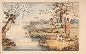
City Hall / To the Honorable Philip Hone, Mayor of the City of New York / This Plate is Respectfully inscribed by his Servant W. G. Wall
Published by Charles Behr, Frederick Kahl, New York, 1826
Engraving with original hand color, 19 3/4" x 28 3/4" sheet. Excellent condition. The depiction of City Hall - iconic in its staging of a democratic institution - derives much of its appeal from the collaboration between Wall and master engraver John Hill. As Koke (1959), p. 52 points out, the latter s artistry resides in his ability to interpret and visually enhance his models. John Hill s engravings are thus a collaborative effort that adapts the painterly qualities of the original drawing or watercolor to the technical idiosyncrasies of its reproduction. Hill was born in London in 1770 and his upbringing and apprenticeship in the British capital reflect the political environment and aesthetic culture during the long reign of King George III. It is furthermore the proliferating booktrade that laid the foundations for the young apprentice s technical mastery in his later American works. Its beginnings, however, can be seen as early as 1801 when he was commissioned to illustrate William Henry Pyne s "Microcosm" of the arts, agriculture, manufactures, trade, and amusements of Great Britain. Only in 1816 did he decide to emigrate to the United States where he bought a house for his family in Philadelphia. Engraving, and especially the aquatint technique, was a still underdeveloped medium in the New World that Hill and his contemporary William Bennett would perfect within decades. Koke (1959), p. 52 confirms: "His prints have been praised for the quality of their execution and the beautiful application of their color. His engraving of New York, Philadelphia, and the American scene have been commended in the highest terms as choice bits of Americana, winning him his repute as one of the most talented and prolific workers in aquatint during the Golden Age of American engraving in the early 19th century." John Hill also set up a printing press in his house and saw through the process from beginning to end. With his commissions for Moses Thomas "Analectic Magazine", he was an important catalyst in the popularization of American landscape painting and the Hudson River School in particular. The print medium allowed him and artists like Joshua Shaw to make their atmospheric landscape depictions accessible to a wider audience and it is in this tradition that one of his major works, the "Hudson River Portfolio", achieved lasting success. Its plates were based on watercolors by William Guy Walls. Though Walls was not regarded as a pre-eminent artist, his paintings were much admired in the newly founded National Academy of Design. It is thanks to his congenial collaborator that the "Hudson River Portfolio" became, in the words of I.N.P. Stokes, "the finest collection of New York State views ever published". The same holds true for his engravings of Manhattan and the view of "City Hall" in particular. Until his death in 1850, this series of prints was never to be surpassed. Lit. Richard J. Koke: "John Hill, Master of Aquatint. 1770-1850", in The New York Historical Society Quarterly 1 (1959), pp. 51-117. #10165B.
-
Manuscript journal of the frigate Potomac's round-the-world cruise
Published by Largely shipboard and at sea, 1831
Seller: Rulon-Miller Books (ABAA / ILAB), St. Paul, MN, U.S.A.
Association Member: ABAA ILAB RMABA
Seller Rating:
Folio (13" x 8�"); pp. [284]; original full calf, roll-tooled borders on covers, red morocco label on spine reading: "Journal," black morocco label on front cover reading: "S. B. Wilson. Lieut. U. S. Navy"; the binding is sound and the manuscript is in a small, neat hand, in ink; very legible. In a custom clamshell box, morocco label on spine. An unpublished manuscript journal of the maiden voyage of the U.S. frigate Potomac kept by one of her two senior lieutenants, Stephen Bayard Wilson (1795-1863) of Clermont, Columbia County, New York on the Hudson River, who first went to sea as a deckhand at the age of fourteen on a ship bound for Calcutta. Potomac, a 1726-ton frigate with a complement of 480 officers and men and armed with 42 thirty-two pounders and 8 eight-inch guns, set sail on her round-the-world cruise flying the pennant of the War of 1812 veteran Commodore John Downes. Downes' original orders did not include a circumnavigation of the globe. He was to deliver Martin Van Buren to England as the American Minister to that country, then proceed via Rio de Janeiro and Cape Horn to Valparaiso where he was to assume command of United States Naval Forces in the Pacific. However, news of the plundering of Salem merchant ship Friendship and the murder of several of her crew in February 1831 by Sumatran natives of Quallah Battoo persuaded President Andrew Jackson to instead redirect the Potomac to "repair at once to Sumatra, by way of the Cape of Good Hope" to atone for this "wanton outrage" - making this the earliest overt example of Gunboat Diplomacy in American history. Potomac would return to Boston three years later having become the first ship in the United States Navy to circumnavigate of the globe from West to East. Wilson's remarks are kept in a journal format, more of a diary than a proper seaman's log. There are no pages dedicated to 24 hours of recorded speeds, wind direction, or courses sailed, etc. (although these pieces of information are often duly recorded in the daily narrative). It's easy to read, understand, and track the voyage day to day. On 26 August 1831, the date the ship weighed anchor and sailed from New York, Lieutenant Wilson records a "List of officers attached to the U. S. Frigate Potomac on her departure from New York the 26th August 1831." Included are Commodore John Downes, Lieutenants Irvine Shubrick, Stephen B. Wilson, Reuben R. Pinkham, Henry Hoff and Jonathan Ingersoll, Asst. Surgeon Jonathan M. Foltz, Schoolmaster Francis Warriner, and Sailing Master Benjamin Totten, a supernumerary en route to join the schooner Dolphin in the Pacific. Lieutenants Shubrick and Wilson were the two senior lieutenants sharing the same date of promotion to that rank on 13 January 1825. Lieutenant Wilson, the author of the journal, rose to rank of Captain in 1855 and died in 1863. Lieutenant Hoff rose to the rank of Rear Admiral in 1867. Of the remaining lieutenants none rose above the rank of commander. The journal opens with a single page containing an abstract log of the entire voyage from leaving New York on 26 August 1831 to arriving in Boston on 23 May 1834, continues with Lieutenant Wilson's orders to report to the Potomac and follows with 3 years of day-by-day descriptions of occurrences including reports of weather, shipboard activities, sail handling and navigation, visits with, or mentions of, ships met (including many whalers, usually giving vessel name, home port, months at sea and amount of oil), provisioning and watering, official and ceremonial visits, deaths, etc. The Potomac sailed from New York to the Cape Verde Islands, then proceeded to Rio de Janeiro, St. Paul, Quallah Battoo (Sumatra), Batavia (Java), Macao, Canton, Oahu, Tahiti, Callao, Valparaiso, Coquimbo, Callao, Paita, the Galapagos Islands, Paita, Callao, Valparaiso, Rio de Janeiro and ended in Boston. In all, over the course of her 3-year journey, the Potomac traveled 61,816 miles. The attack on the natives of Quallah Battoo occurs early in this journal, and is described in considerable detail, beginning with the dispatch and initial approach of an American landing party on February 6, 1832. Lieutenant Wilson writes, "at 9 the Expedition returned from the shore, having destroyed the Forts and left the Town in flames, and bringing the bodies of Wm P. Smith, sea[man], killed, and Benjn T. Brown, Marine killed, together with the following wounded. [a list of 8 men follows]. He goes on to describe the bombardment by "Potomac's" guns two days later, completing the destructive work of the landing party, and leaving the entire settlement in flames . At 2 [pm] observed the Forts on shore had hoisted White Flags." On February 9, an emissary from the settlement came aboard to discuss "a cessation of Hostility." After the battle, the Americans remained in the vicinity for several more days, taking on wood and water and performing maintenance, until their departure for Batavia on February 18th. In all, Wilson writes about 1750 words covering their engagement at Quallah Battoo. The Dictionary of American Naval Fighting Ships states, "Of the 282 sailors and Marines who landed, two were killed while 150 natives, including the village chieftain, Po Mahomet, died for their piracy." Potomac arrived in Batavia at the end of March, then proceeded to Macao, arriving in mid-May. After taking on fresh provisions and visiting Canton, they sailed for Hawaii, reaching Woahoo (Oahu) by the end of July, where they received King Kamehameha on board. On August 5, Wilson writes, "Received a visit from His Majesty Tamehameha 3rd, King of the Sandwich Islands and suite, Saluted him with 21 Guns." (This, incidentally, was the first entertainment of royalty aboard a U. S. Navy ship.) In recognition of the honor, King Kamehameha presented the Potomac with 40 hogs. From Hawaii, they went on to Tahiti and, on September 19, "the Queen Dowager of the Island visited the ship." Then on to the west coast of South America - Callao, Va.
-
Limited Editions Club, 1929-1985
Published by Limited Editions Club, New York
Book First Edition Signed
Hardcover. Condition: Very Good. Dust Jacket Included. 1st Edition. A tremendous Limited Editions Club opportunity for the serious collector. This collection comprises 383 issues (considerably over 400 volumes) of the total 599 issues published by the George H. Macy-founded Limited Editions Club over the years 1929-1985. All volumes in this collection are in at least VG condition, most better. All are slipcased, and all slipcases are also VG or better. Many of the books are also housed in their original glassine dustjackets, whose condition--given their fragile nature--varies considerably. This collection includes such highly collectible and infrequently available titles as: Ray Bradbury's "Fahrenheit 451"; Robert Louis Stevenson's "Two Medieval Tales"; "The Little Flowers of Saint Francis of Assisi"; James Fenimore Cooper's "The Last of the Mohicans"; Alexandre Dumas' "The Count of Monte Cristo" and "The Three Musketeers"; Geoffrey Chaucer's "The Canterbury Tales;" Francois Rabelais' "Gargantua & Pantagruel;" Alexandre Dumas-fils "Camille"; Victor Hugo's "Les Miserables"; William Henry Hudson's "Far Away and Long Ago"; Stephen Crane's "The Red Badge of Courage"; "The works of Epicurus"; "The Complete Hans Christian Anderson"; "The Complete Poems of Robert Frost"; Edmund Spenser's "The Faerie Queene"; Saxo Gramaticus' "The History of Amleth, Prince of Denmark"; Fyodor Dostoevsky's "The Idiot" and "The Possessed"; "Meditations of Marcus Aurelius"; Thomas Hardy's "Far From the Madding Crowd"; "The Histories of Herodotus of Helicarnassus"; Rudyard Kipling's "Kim"; Jules Verne's "Around the World in 80 Days" and "A Journey to the Center of the Earth"; The Brothers Grimm's "Grimm's Fairy Tales Complete"; H.G. Wells' "The War of the Worlds and The Time Machine"; Friedrich Nietzsche's "Thus Spake Zarathustra"; "The Dead Sea Scrolls"; Erich Maria Remarque's "All Quiet on the Western Front"; Sir James Frazier's "The Golden Bough"; Charles Baudelaire's "The Flowers of Evil"; Aldous Huxley's "Brave New World"; Thornton Wilder's "Our Town"; Franz Kafka's "The Trial"; "Selected Poems of Rainer Maria Rilke"; F. Scott Fitzgerald's "Tender is the Night"; Charles G. Finney's "The Circus of Doctor Lao"; Czeslaw Milosz' "The Captive Mind"; and Kenneth Grahame's "The Wind in the Willows," and many more. Please contact us if you would like a complete printed listing at $10.00. The collection comprises approximately 45 medium-size boxes of books, as well as a large box of ephemera. (Chalk "art" on certain box sides, courtesy of my 5-year-old, can also be included free of cost, but be warned, they are unlikely to survive shipping.) Shipping is at the purchaser's discretion and cost. If requested, we can make suggestions regarding reliable shippers. In uncertain economic times, what better way to invest your capital than in items of lasting value you can hold in hand and enjoy?. Signed by Illustrator(s).
-
A State of the Expedition from Canada as laid before the House of Commons, and verified by evidence; with a collection of authentic documents, and an addition of many circumstances which were prevented from appearing before the House by the prorogation of Parliament
Published by J. Almon, London, 1780
First Edition Signed
Hardcover. Condition: Very good. First. First edition. London: Printed for J. Almon, 1780. Quarto (11 1/16" x 9", 281mm x 230mm). [Full collation available.] With six hand-colored (outlined) folding engraved maps. Bound in publisher's blue boards, backed in buff paper. Edges of the text-block untrimmed. Presented in a blue cloth slipcase with a chemise. A completely unsophisticated copy. Some wear to the extremities of the boards, and some soiling. Backing mostly perished. Bottom of the front joint split. Some tanning and occasional foxing, but generally quite clean internally. A little offsetting to the maps. A closed tear (from opening the sheets) to the upper edges of L3-4, with a little loss to the upper fore-corners. Bookplate of George Clinton Ward to the front paste-down. Signed bookplate of Bruce McKinney (from his sale, Bonham's New York 2 December 2010 "The American Experience," lot 110) tipped in to the chemise. John Burgoyne (1722-1792) was put in command of the British forces in Canada in 1777 after outlining what he considered the errors and insufficient boldness of his own commanding officer, Guy Carleton. His plan was to move south from Quebec and to retake the entire Hudson River valley down to the City of New York, with the aim of stranding New England from southern reinforcement. He got only as far as Saratoga, having failed to coordinate his rendezvous with the forces of Clinton and Howe. On 17 October he surrendered the whole of his army, some 5,800 men, to Horatio Gates. It was the Americans' greatest victory to date, and was crucial in convincing the French to join the fight. Modern historians consider the episode the critical point in the American Revolution's success. "Gentleman Johnny" returned to Britain with Washington's permission in order to defend his conduct, and the present volume is the account of that defense to the House of Commons, and more broadly to rehabilitate his career and to restore his name. That was his sole victory; he would go on to be a Privy Councilor, Commander-in-Chief of Ireland and Colonel of the King's Own Regiment -- to say nothing of a considerable success in the theatre, both on his own and in partnership with Richard Brinsley Sheridan. The present volume is a rather remarkable survival in boards. George Clinton Ward (1863-1933) was a native New Yorker who transplanted to California at the insistence of Henry E. Huntington, who doubtless nourished his collecting habit. Ward would go on to be president of the Southern California Edison Company. The volume was later owned by another Californian, Bruce McKinney. McKinney founded the Americana Exchange, now Rare Book Hub, the central database of book auction records. Howes B-968, Sabin 9255, Staton & Tremaine/PRL 503, Streeter sale II:794.
-
Sketchbook
Published by New York City, 1828
Seller: White Fox Rare Books, ABAA/ILAB, New York, NY, U.S.A.
Association Member: ABAA ESA ILAB PBFA
Seller Rating:
Condition: Good. Original watercolors of rural Manhattan as it appeared in 1828. Among these, and captioned, are a farmhouse on Broadway and 8th Street; Kips Bay, showing a boy sailing a small craft with a farmhouse in the background; a house in Bloomingdale, the location of an early village now the Upper West Side along the river between 96th and 106th Streets; and a stately mansion surrounded by fields and less important buildings we would conjecture in or around Bloomingdale but captioned, surely incorrectly, the Battery. Most of the paintings are uncaptioned. Of these, some are surely the Upper Hudson area, or are scenes that we can't tell whether they are upstate or in the present day city. The artist also ventured away from the New York areas. Among the non-New York paintings are a depiction of the Cape Pogue Lighthouse on Martha's Vineyard, which still stands; Fowey Harbour, which is in Cornwall; and a few scenes which look very much like Scotland. Oblong, 14 by 19.5 cm. 55 watercolors, generally fully finished. Although the sketchbook has a label on its front board bearing the name of Walter Oddie, who was a listed artist, we believe a good amount of the artwork contained in this sketchbook is of his father-in-law, Henry Meigs. Meigs had been a U.S. Congressman from New York and also held a number of other political positions in the city over the course of his career. More pertinently, Meigs was known to be an amateur painter, and as such, an inspiration to Oddie. Given Oddie s youth at the time -- he was 20 or 21 years old and from his diary for the years 1828 and 1829, now housed in the Winterthur Library, we know he was just starting to paint, we find it inconceivable that he would have had the skill yet to produce the sensitive and fine renderings of nature and buildings that typify this sketchbook. Further underlying our thinking about attribution is that some of captioning only makes sense if Meigs were the primary artist. We do consider it quite likely that Oddie may have done some of the sketchier work contained herein, as well as contributing in bits and pieces to his father-in-law s work, as well as perhaps copying some of it in this sketchbook. To us, it isn t really so important who was responsible for particular paintings in the sketchbook. Rather, the significance lies in the recording of New York City and its surroundings at the time we suspect that there may be no recording anywhere of some of the buildings and locations at this time. And of course, not to be minimized, is the beauty of the better paintings contained in the sketchbook.Whatever the degree of Oddie s contribution, the sketchbook does have something to say about his career, and visa versa, given that it contains the type of artwork for which he became known later. Oddie was born in Maryland, Washington, D.C. or possibly New Orleans, but spent almost his entire life in New York, and more specifically, New York City, Brooklyn or Long Island. In 1828, the year most of the watercolors in the catalogue were executed, Oddie was spending much of his time in the city.Once Oddie s interest in painting was sparked, he was believed to have been largely self-taught, but he did come to study art with Hudson River School painter Robert Walter Weir and Anthony Lewis De Rose, a portrait and historical painter. From the diary we know that Oddie did work with De Rose in 1829; we believe that his tutelage with Weir came later. From the diary we know that Oddie was regularly going to art exhibits and critiquing what he saw. The diary also discloses, or corroborates our prior sense, that Oddie sometimes would work off of engraved prints. To what degree he was merely copying the prints, as opposed to using the prints as a spur to his own imagination, we can not determine with certitude. We tend to think the views of Scottish and Welsh castles contained in the Sketchbook were done by Meigs, not Oddie, and so they might well have been done from life.From the diary we know tha.
-
INFUSORIA : JOURNAL - manuscript folio note-book titled VOL.IV Infusoria on the opening page, with entries dated APRIL 2nd.1850, ending DECEMBER 12th 1887, pages 210 [part 1] and leaves 32 [part 2 - Notes made in 1886. Sept. 1 : forward], entries dated AUGUST 30th. 1886, ending FEBRUARY 12th. 1887. The JOURNAL portion begins from the end and runs back, comprising 5 leaves with notes on MAMMALIA : BIRDS : FISHES : INSECTS : REPTILES. In addition, there is a small bundle of ms. notes [rotifer species lists and anatomy notes, page references to Vols.I-IV, possibly HUDSON & GOSSE Rotifera] plus 2 ALS from one FRED D. DYSTAN, see below.
Seller: Patrick Pollak Rare Books ABA ILAB, SOUTH BRENT, DEVON, United Kingdom
Seller Rating:

Signed
This volume is vellum-bound, the paper watermarked for C. HARRIS 1846, the stationer's label for FREDERICK WALLER, 49 Fleet Street, London, the front free end-paper with Gosse's name written as in plate 4 of FREEMAN & WERTHEIMER Bibliography, the front board with label 'INFUSORIA.4.', the rear board with 'Journal' in script. A pencil note in Richard Freeman's hand, signed by him, reads : 'Given to me on my sixtieth birthday . 1 April 1975.' *The major portion of the Infusoria comprises detailed descriptions of some 75 species of Rotifer, each entry dated, with reference to a figure, the location found [many from Hampstead Heath, Berger's Lily Pond, the fountains of Trafalgar Square, Kensington Palace]. Part 2 is primarily a list of approx. 31 species, most of which are ascribed GOSSE, some with the postscript 'n.sp.' [new species?]. SEE - FREEMAN and WERTHEIMER Bibliography, 1980, #169-172 (1886-1889) - 'The rotifers had early attracted Gosse's attention and he had published seventeen papers on them, the first in 1850. He had also accumulated a large amount of unpublished descriptions and drawings.' F & W also refer to Gosse's original manuscripts : 'One of Gosse's notebooks on rotifers which was used in his articles in the Journal of the Royal Microscopical Society and then in this book, is in the Zoological Library of the British Museum (Natural History); another, entitled 'Drawings of Rotifera; by Philip Henry Gosse, F.R.S. Sept. 1886' is in the University of Toronto (see Nos. 399-401). A large bound folio volume entitled 'The original drawings of the Rotifera (Clifton, 1886)' at the Royal Society (MS 132) contains mostly original drawings by Hudson, some copies by him of Gosse's drawings, and some original ones by Gosse himself.' The rarity of this volume speaks for itself ! The ALS from Fred Dystan - 'Dear Gosse I am glad you are better, which I suppose I may assume from your writing . I think it is great humbug that you won't let me name my own beast. I use the word in a Pickwickian sense but I see no impropriety in your working on a beast I had already named. However I must leave it with you, as I cannot undertake to publish it myself .'. There is, in addition, a second letter from this correspondent, 7 sides, dated Oct.7th.1856, dealing with details of the Rotiferae.
-
The North Part of America Conteyning Newfoundland, new England, Virginia, Florida, new Spaine, and Nova Francia
Published by London: William Stanley for Henrie Featherstone, 1625-1626., 1626
The north part of America conteyning Newfoundland, New England, Virginia, Florida, New Spaine and Nova Francia, with ye rich Iles of Hispaniola, Cuba, Jamaica and Porto Rieco on the south and upon ye west the large and goodly island of California. The bonds of it are the Atlantick Ocean on ye South and East sides ye south sea on ye west side and on ye North Fretum Hudson and Buttons baye a faire entrance to ye nearest and most temperate passage to Japan & China Single sheet, float-mounted and framed (12 4/8 x 14 inches, full margins showing the plate mark; framed size 21 4/8 x 23 4/8 inches). A fine engraved map of North and most of Central America by Reynold Elstracke, the title within an elegant mannerist cartouche upper right, notably showing California as an Island. Published in Samuel Purchas's 'Purchas his Pilgrimes', 1625, in Book IV to illustrate "English Northerne Navigations, and Discoveries, Relations of Greeneland, Groenland, The North-West Passage, and other Arctike Regions, with later Russian Occurrents" and is best known for being the PROGENITOR OF THE MYTH OF CALIFORNIA AS AN ISLAND, but since it may have been published as early as 1622 it is also proposed as the first map to name "Hudsons bay", "Fretum Hudson", "Hudsons R", "Cape Cod", and "De la war bay" (Burden 314). 'Purchas his Pilgrimes' was a great geographical collection and a continuation and enlargement of Hakluyt's 'The Principal Navigations'. When Hakluyt died he left a large collection of voyages in manuscript which came into the hands of Purchas, who added to them many more voyages and travels. As an editor and compiler, Purchas sought to interest the general public of his day in the dramatic geographical discoveries that had taken place with remarkable rapidity over the previous 140 years. During a time when travel literature had the patriotic purpose of inspiring Englishmen to engage in overseas expansion and enterprise, his collections were read with enthusiasm. 'Purchas his Pilgrimes' and the maps it included have a momentous historical significance, for they are frequently the only sources of information on important questions relating to geographical history and early exploration. Henry Briggs, a noted scholar and mathematician of the time, his map, engraved by Reynold Elstracke, is desirable today as the first map to show California as an island, a geographic misconception that endured for centuries and has inspired numerous books and generations of map collectors. The map contains three legends including "California sometymes supposed to be a part of ye westerne continent, but scince by a Spanish Charte taken by ye Hollanders it is found to be a goodly Ilande". The map notes the expedition to the west coast of Sebastian Vizcaino in 1602-1603, possibly showing P.S. Diego and S. Clement for the first time. It was Friar Antonio de la Ascension' account of that expedition which is believed to be the source of the theory of California as an Island. The map was also one of the first to propagate rumors of the existence of a Northwest Passage, based on the accounts of recent explorations. The map s text promises that Hudson s Strait and Button s Bay provide a "fair entrance" to the South Sea -- in other words, they are the gateway of the passage. This map, widely followed by later mapmakers, truly deserves the attention it has received. The concept it spread of California being an island took hold among even the most sophisticated mapmakers. Although it was refuted by Father Kino in 1698 when he traveled to the west coast of California, it still took a royal decree from Ferdinand VII of Spain in 1747 to finally persuade cartographers to alter their delineations.
-
[Six Remarkable Views in the Provinces of New York, New Jersey and Pennsylvania: Engraved after the Paintings made by Mr. Paul Sandby, from the Drawings taken on the spot by his Excellency Governor Pownall]
Published by printed for John Bowles, Robert Sayer, Thos. Jefferys, Carington Bowles and Henry Parker, [London, 1768
Seller: Donald A. Heald Rare Books (ABAA), New York, NY, U.S.A.
Seller Rating:
Oblong folio. (17 1/4 x 24 inches). Complete suite of 6 engraved views. Expertly bound to style in half russia and combed marbled paper covered boards. Very rare complete suite of among the most beautifully engraved views of North America in the 18th century. The plates are titled as follows: 1) A View in Hudson's River of the Entrance of what is called the Topan Sea. Engraved by Peter Benazech after Pownal and Paul Sandby. 2) A View of the Falls on the Passaick, or second River, in the Province of New Jersey. Engraved by Paul Sandby, after Pownall and Sandby. 3) A View in Hudson's River of Pakepsey & the Catts-Kill Mountains, From Sopos Island in Hudson's River. Engraved by Paul Sandby, after Pownall and Sandby. 4) A View of the Great Cohoes Falls, on the Mohawk River; The Fall about Seventy feet, the River near a Quarter of a Mile broad. Engraved by Wm. Elliot, after Pownall and Sandby. 5) A View of Bethlem [sic.], in the Great Moravian Settlement in the Province of Pennsylvania. Engraved by Paul Sandby, after Pownall and Sandby. 6) A Design to represent the beginning and completion of an American Settlement or Farm. Engraved by James Peake, after Pownall and Sandby. Published following the conclusion of the French and Indian War, and in a period of great public interest in the American colonies, the Scenographia Americana was the first book dedicated to a large-scale artistic depiction of the American landscape. From the Gulf of St. Lawrence to the West Indies, the scenes include locations of battles, views of strategic provincial capitals, and newly secured areas of commercial importance. Just as clear is the celebration of nature's 'astonishingly great' expanse, to cite Pownall, great in width and in height. Here are harbors and rivers, cascades, forests and skies" (Hood). In 1768, the plates were published in two forms, the complete set of 28 engraved plates (priced at four guineas); or as seven separate suites as follows: six views of Canada after Smith (plates 1-6, priced 1 guinea); two views in Canada (plates 7-8, priced 7s); two views of New York after Howdell (plates 9-10, priced 7s); two views of Boston and Charlestown, South Carolina (plates 11-12, priced 7s, 6d for the pair or 3s, 6d individually); six views after Pownall (plates 13-18, priced 1 guinea) [as here]; six views of Havana after Durnford (plates 19-24, priced 1 guinea); and four views in the West Indies after Campell (plates 25-28, priced 14s). Thomas Pownall arrived in America in 1753 to serve as Secretary to Governor Danvers Osborne. Within a week of his arrival, however, the Governor died unexpectedly. Nevertheless, Pownall chose to remain in America, and travelled extensively through the middle colonies, producing sketches of the frontier landscapes and settlements which he deemed remarkable. Following the end of the French and Indian War, his sketches were worked up into paintings by Royal Academy artist Paul Sandby and engraved. Sandby would later become the Chief Drawing Master of the Royal Military Academy at Woolwich, charged with training engineers to document the expanding landscape of the British Empire. "His translations of Pownall's visual impressions were given to the Publick whose tastes for landscape observations and printed views, especially in the picturesque style, were emerging in England at the time . [Pownall and Sandby's views] reveal formative topographical features and the industrious spirit that forged an identity for individuals who were naturalised in the context of the American wilderness. Prior to the American Revolution, while the Provinces were under the control of England, Pownall's work also satisfied a European desire to visualise this previously unknown setting as an intellectual curiosity. The natural environment of the New World was a model subject for the implementation of aesthetic landscape principals that were emerging in England at the time of Pownall's travels. Such principles perhaps shaped Pownall and Sandby's reflections and led them to embellish topographical depictions with an Anglo vision for ordered industrial, spiritual, and scenic composition an approach that made the views more comprehensible to an English audience comfortable with certain landscape aesthetics and excited to see views of Englands territories abroad. This practice would come to be replicated by subsequent travelers who followed a similar tour to Pownall's and further attempted to draw British North America into existence by way of a distinctly European lens" (Brett Culbert, "View of the Middle Colonies"). Sabin 81486; Deak, Picturing America, 107; Stokes, The Iconography of Manhattan Island 1498-1909, I: pp. 281-295; Stokes, American Historical Prints B-92; Fowble, Two Centuries of Prints in America, 25-30; John E. Crowley, "The Scenographia Americana (1768): A transnational landscape for early America" in Common-Place, vol. 6, no. 2 (January 2006); Donald F. Clark, "Six Remarkable Views, 1761: the Collaboration of Governor Pownall and Paul Sandby" in Imprint, vol. 4, no. 1 (April 1979); Graham Hood, "America the Scenic" in Colonial Williamsburg Journal, Spring 2009; Spendlove, pp. 6-8.
-
![Seller image for A plan of Fort Montgomery and Fort Clinton, taken by His Majesty's forces, under the command of Maj. Gen.l Sir Henry Clinton, K.B: Survey'd by Major Holland, Surv.r Gen.l &c. . [With large inset titled:] Part of Hudsons River, shewing the position of Fort Montgomery and Fort Clinton, with the Chevaux de Frieze, cables, chains, &c to obstruct the passage of his Majesty's forces up the river. By Lieut. John Knight of the Royal Navy in 1777 for sale by Donald A. Heald Rare Books (ABAA)](https://pictures.abebooks.com/inventory/md/md22396106308.jpg)
A plan of Fort Montgomery and Fort Clinton, taken by His Majesty's forces, under the command of Maj. Gen.l Sir Henry Clinton, K.B: Survey'd by Major Holland, Surv.r Gen.l &c. . [With large inset titled:] Part of Hudsons River, shewing the position of Fort Montgomery and Fort Clinton, with the Chevaux de Frieze, cables, chains, &c to obstruct the passage of his Majesty's forces up the river. By Lieut. John Knight of the Royal Navy in 1777
Published by London, 1779
Seller: Donald A. Heald Rare Books (ABAA), New York, NY, U.S.A.
Seller Rating:
Map
Engraved and aquatint map, period hand colouring. 14 lettered references, large inset with title as above. Rare revolutionary chart of the Hudson River showing the American defenses, on the eve of the Battle of Fort Montgomery. On October 6, 1777, a British force led by Lieutenant General Sir Henry Clinton attacked Forts Montgomery and Clinton from the landward side, where the American defenses were only partially completed. Support from cannon fire from British ships on the Hudson River that had passed through the chevaux de frise on the lower river. By the end of the day, both forts had fallen to the British, who burned the forts and tore down the stonework buildings. However, the battle was a pyrrhic victory for the British. The campaign against the forts caused delays in reinforcing General John Burgoyne at Saratoga, where Americans forced the British surrender ten days later at the Battle of Saratoga before Clinton's forces could arrive. The present map, which depicts the Forts and the River defenses prior to the battle, is from The Atlantic Neptune, the finest large scale sea atlas of the United States and Canadian Atlantic coastline ever produced. The maps in the atlas were produced over a seven-year period (1775-82), and are well known for their accurate portrayal of various sounds, bays, bars, harbors as well as navigational hazards. This atlas was used extensively by the Royal Navy during the American Revolution. Des Barres studied under the great mathematician Daniel Bernoulli at the University of Basel, before continuing on to the Royal Military College at Woolwich. On the outbreak of the Seven Years war in 1756, he joined the British Royal American Regiment as a military engineer. He came to the attention of General James Wolfe, who appointed him to be his aide-de-camp. From 1762, Des Barres was enlisted to survey the coastlines of Nova Scotia, Newfoundland, and the Gulf of St.Lawrence, while his colleague, Samuel Holland charted the New England coast and further south. In 1774, Des Barres returned to England where he began work on the Neptune. His dedication to the project was so strong, that often at his own expense, he continually updated and added new charts and views up until 1784. That year he returned to Canada, where he remained for a further forty years, becoming a senior political figure and a wealthy land owner, and living to the advanced age of 103. The Atlantic Neptune was the first British sea atlas of her North American colonies, and one of the most important achievements of eighteenth century cartography. With an official commission from the Royal Navy, Des Barres published the first volume in London in 1775, which was soon followed by further volumes. Des Barres' monumental endeavor eventually featured over two-hundred charts and aquatint views, many being found in several states. All of the charts were immensely detailed, featuring both hydrographical and topographical information. The Neptune met with the highest acclaim from the beginning, and is today widely regarded as superior to all other atlases produced during its time. Henry Stevens identified only a single state of this chart, issued coloured or uncoloured, which appeared in some examples volume four, part two of the Atlantic Nepture; the map, however, is not listed in the engraved list of maps for that section, and given the rarity was likely not issued in all copies. National Maritime Museum: Henry Stevens Collection: HNS156; Cf. Phillips, Atlases 1198; Hornsby, Surveyors of Empire: Samuel Holland, J.F.W. Des Barres and the Making of the Atlantic Neptune (2011).
-
Hand-colored etching and aquatint, 13 �" x 37 �" sheet. As pointed out by Stokes (1918) the "Panoramic View of New York Taken From the North River" exists in different states; the present copy was published in the 1840s and unlike earlier editions, it shows a two-funnel steamer, as well as the dome of the Merchants Exchange on Wall Street. The latter also suggests that Havell drew his view some time after the fire of December 16, 1835 when the first Merchants Exchange was destroyed; the new building was only completed in 1840. Together with the additional publisher s line, this points towards the identification of the Arader print as the fifth state of the famous cityscape. As for the colorist, it is safe to recognize the hand of Henry Havell - Robert s brother - in the delicate handling of the blues. He lived in New York during the years 1844-45 and is recorded as "printcolourer" (sic) at 7 � Bowery. Robert Havell is best known as the formidable engraver of John James Audubon s "Birds of America". As one of the pre-eminent English engravers, his name first appears in connection with the Audubon elephant folios. In 1839 he emigrated to the United States and after an initial stay in Brooklyn, he settled in Ossining and Tarrytown where he perfected his skills in the engraving and aquatinting of city views, as well as in the depiction of landscape scenes. Havell is considered a member of the Hudson River School. Lit. Isaac Newton Phelps Stokes: "The Iconography of Manhattan Island", New York 1915-1928. #10165F.
-
Questa carta contiene la costa Del India Orientale con la costa di Coromandell e' l'Isola di Zeilan e' finisce con la parte Tramontn.a di Sumatra
Published by [Florence: 1646 or later]., 1646
Two sheets, joined (19 2/8 x 30 inches to the neat line, full margins showing the plate mark), matted. Fine engraved map showing the coasts of India and Sumatra, with fine cursive lettering, the title in an elaborate cartouche of fish, decorated with a compass rose and two-masted ship. Exceptionally fine engraved map from "Dell'arcano del mare", THE FIRST ENGLISH NAUTICAL ATLAS AND THE FIRST MARITIME ATLAS TO USE THE MERCATOR PROJECTION. Robert Dudley's "Secrets of the Sea" is "ONE OF THE GREATEST ATLASES OF THE WORLD and one of the most complex ever produced: it is the first sea-atlas of the whole world; the first with all the charts constructed using Mercator's new projection, as corrected by Edward Wright; the first to give magnetic declination; the first to give prevailing winds and currents. the first to expound the advantages of "Great Circle Sailing"; and . the first sea-atlas to be compiled by an Englishman." (Lord Wardington). Dudley's monumental work was the only exception to the total dominance of sea-atlas production by the Dutch for nearly a century. The complete work contained nearly 150 sea charts as well as dozens of illustrations and working diagrams. It was superior to any previous work in that the charts illustrated the whole world, the first time any outside of Europe had been included. His atlas was also the first to importantly show the prevailing winds, currents and magnetic deviation. In using the projection developed by Mercator, Dudley improved upon the theory of navigating by the "Great Circle," the shortest distance between two points on a globe. It was not until the eighteenth century that cartographers used the projection consistently, and during the prolonged period when the Dutch dominated cartographic production, not one atlas was published using it. This magnificently engraved work is an encyclopedia of seventeenth-century knowledge regarding the seas. Dudley was one of the more colorful and adventurous characters in the history of mapmaking. The illegitimate son of the Earl of Leicester and Lady Douglas Sheffield, but unable to establish his claim to the title of Earl of Leicester, Dudley left England in 1605. Arriving in Florence, Dudley entered the service of the Cosimo II, Grand Duke of Tuscany, as an engineer and naval commander. In 1646, Dudley published "Arcano del mare", the whole written in Italian by Dudley himself. The atlas was twelve years in the making, and the main innovation lay in its conception of a world atlas of charts, both general ocean charts and detailed surveys, covering all the rival spheres of European dominion: Spanish, English and Dutch. Dudley's sources included the original charts of Henry Hudson, and for the Pacific coast he used the observations of Henry Cavendish, the third circumnavigator of the globe and Dudley's brother-in-law.
-
Carta particolare che comincia con il capo Dofar in Arabia e finisce con il capo Cintapora nell Indie
Published by [Florence, 1648, or later]., 1648
Two sheets joined (19 2/8 x 29 4/8 inches to the neat line, full margins showing the plate mark), matted. Fine engraved map showing the coasts of the south-eastern part of the Arabian peninsula, north of Dhofar, the first including the southern part of the Red Sea, the second extending round to India, just north of Goa, with fine cursive lettering, the title in an elaborate cartouche of a shell, decorated with a compass rose and two-masted ship. Exceptionally fine engraved map from "Dell'arcano del mare", THE FIRST ENGLISH NAUTICAL ATLAS AND THE FIRST MARITIME ATLAS TO USE THE MERCATOR PROJECTION. Robert Dudley's "Secrets of the Sea" is "ONE OF THE GREATEST ATLASES OF THE WORLD and one of the most complex ever produced: it is the first sea-atlas of the whole world; the first with all the charts constructed using Mercator's new projection, as corrected by Edward Wright; the first to give magnetic declination; the first to give prevailing winds and currents. the first to expound the advantages of "Great Circle Sailing"; and . the first sea-atlas to be compiled by an Englishman." (Lord Wardington). Dudley's monumental work was the only exception to the total dominance of sea-atlas production by the Dutch for nearly a century. The complete work contained nearly 150 sea charts as well as dozens of illustrations and working diagrams. It was superior to any previous work in that the charts illustrated the whole world, the first time any outside of Europe had been included. His atlas was also the first to importantly show the prevailing winds, currents and magnetic deviation. In using the projection developed by Mercator, Dudley improved upon the theory of navigating by the "Great Circle," the shortest distance between two points on a globe. It was not until the eighteenth century that cartographers used the projection consistently, and during the prolonged period when the Dutch dominated cartographic production, not one atlas was published using it. This magnificently engraved work is an encyclopedia of seventeenth-century knowledge regarding the seas. Dudley was one of the more colorful and adventurous characters in the history of mapmaking. The illegitimate son of the Earl of Leicester and Lady Douglas Sheffield, but unable to establish his claim to the title of Earl of Leicester, Dudley left England in 1605. Arriving in Florence, Dudley entered the service of the Cosimo II, Grand Duke of Tuscany, as an engineer and naval commander. In 1646, Dudley published "Arcano del mare", the whole written in Italian by Dudley himself. The atlas was twelve years in the making, and the main innovation lay in its conception of a world atlas of charts, both general ocean charts and detailed surveys, covering all the rival spheres of European dominion: Spanish, English and Dutch. Dudley's sources included the original charts of Henry Hudson, and for the Pacific coast he used the observations of Henry Cavendish, the third circumnavigator of the globe and Dudley's brother-in-law.
-
Delineations of British Field Sports, together with the various methods of poaching
Published by London J. Hudson, 1822
Book First Edition
First edition, oblong folio (28.6 x 45.6 cm); 24 hand-coloured lithographs, plate 13 just trimmed by the binder, shallow crease in the first plate, a few short marginal tears of which one repaired, faint stain in the top margin of the first few leaves; later red half morocco, spine gilt in compartments, sides with gilt double fillet, top edge gilt, marbled endpapers (extremities rubbed, boards spotted, light soiling), a very good copy. 'The coloured issue ranks as one of the rarest sporting books of the period. There is only a record of a second coloured copy, which is untraceable' (Schwerdt). Delineations is the only book published by Samuel Alken, Henry Thomas Alken's brother; it was first issued in six monthly parts in wrappers (no copy known), and then in book form in two states: uncoloured on drab paper, as Mellon, or the more luxurious issue with coloured lithographs on white paper, as here. Schwerdt notes that the vigorous style of these plates made them eminently suitable for framing, and accounts in part for their rarity; 'twenty years' search has not enabled us to make up a complete set'. Later in the collection of Hugh Auchincloss, attorney and power broker, and stepfather to both Gore Vidal and Jacqueline Kennedy Onassis. Not in the British Library; not in Abbey, Dixon, or Tooley. WorldCat locates just one copy, the Mellon copy, at Yale's Sterling Library; that one uncoloured and on grey paper.
-
mit altem Grenz- und Fl�chenkolorit, nach 1755, jedes Blatt in Atlasfolio. Verkleinerter Nachstich der wichtigsten Karte Nordamerikas des 18. Jahrhunderts durch Covens und Mortier. Zur Erstfassung vergleiche Tooley, Mapping of America, S. 315/316 und J. Q. Bennet: 'The Cartographic Treasures of the Lilly Librarry' in 'Map collector', Nr. 22, S. 30 ff. 'Our American maps of the eighteenth century include examples by . Le Rouge, Visscher, Sayer and John Mitchell . Most important of these is the twenty sheet map of Henry Popple, London, 1733 .'. Die Karten im einzelnen: Blatt 1: Indexkarte: 'A Map of the British Empire in America', 49 x 48 cm. (H) - Mit fig. Kartusche, maritimer Staff., links und rechts oben je 2 Stadtansichten (Niagara u. Mexiko, sowie Quebec und New York) und am rechten Rand eine Leiste mit kleinen Festungsgrundrissen; laut M. Babinski (herzlichen Dank an dieser Stelle!) state 2 (von 2): 'Dutch' im Titel ersetzt 'Hollandish'; Bl�tter 2 - 5: Reduktion der eigentlichen 20-bl�ttrigen Wandkarte jetzt in 4 Blatt mit je einem Kopftitel: - Nouvelle Carte Particul�re de la Amerique ou sont exactement marqu�ese une Partie de la Baye d'Hudson, le Pays Kilistinons, la Source de la Grande Rivi�re de Mississipi, le Pays des Illinois &c.; - Nouvelle Carte Particul�re de la Amerique ou sont exactement marqu�es la Nouvelle Bretagne, le Canada ou Nouvelle France, la Nouvelle Ecosse, la Nouvelle Angleterre, la nouvelle York, la Pensilvanie, Mary-land, la Caroline septrionale, l'Ile de terre Neuve. le Grand Banc &c. - Nouvelle Carte Particul�re de la Amerique ou sont exactement marqu�es les Provinces suivants comme la Caroline meridionale, la Floride, la Louisiane, le Mexique,le Jucatan, le Guatimala, le Darien,& une Partie de Cuba. - Nouvelle Carte Particul�re de la Amerique ou sont exactement marqu�es lesIles de Bermude, la Jamaique, Saint Domingue, les Antilles, la Terre Ferme &c. Gesamtgr��e 110 x 102 cm. Ohne Ansichten, aber mit maritimer Staffage und 2 dek. Kartuschen, diese Bl�tter je 2x gefaltet. Babinski state 3 ('Lake Erie' jetzt 'LAKE ERIE or OKSWEGO'), unterhalb von Lake Erie Schlachtensymbol und die Ortsbezeichnung 'Little Meadows' mit der Datierung '9 July 1755'. In der n�heren Umgebung 'Ft. du Quesne' und 'Ft. Cumberland', sowie in Louisiana 'N. Orleans' - diese Ortsbezeichnungen tauchen in Zustand 3 der vierbl�ttrigen Karte erstmals auf. Blatt 6: Die vier Ansichten aus dem Indexblatt, jetzt vergr��ert auf je 13 x 26 cm (Originalgr��e der Ansichten auf der Karte v. Popple, 1733), zusammen auf einem Blatt. Blatt 7: mit Kopftitel 'Les principales Forteresses Ports & de L' Amerique Septentrionale', 48 x 60 cm. Unter den Teilkarten und Grundrissen folgende Festungen (H�fen): Placentia, Anapolis, Boston, New York u. Perthamboy, Charles Town, St. Augustin, Havana, Port Antonio/Jamaika, Fort Royal/Martinique und Karten der Inseln Bermudas, Curacao, Barbados, Antiqua . Zu Popples Karte, ihren Zust�nden sowie der Reduktion von Covens & Mortier siehe ausf�hrlich: Mark Babinski: 'Henry Popple's 1733 Map of The British Empire of America', 1998/2001. Auch in dieser Fassung bei Covens/Mortier sehr seltene Folge! Stopp/Langel, S. 22 kennt nur die Karten 1 - 5. Koeman, C & M 11 kennt nur die Bl�tter 2 - 7, das Indexblatt bei Koeman nicht verzeichnet. - Alle Karten in ausgezeichneten Drucken, fleckenfrei und breitrandig.
-
Itineraire Pittoresque du Fleuve Hudson
Publication Date: 1829
Seller: Bauman Rare Books, Philadelphia, PA, U.S.A.
Association Member: ABAA ILAB PBFA
Seller Rating:
First Edition
First Edition. "MILBERT, Jacques-Gerard. Itineraire Pittoresque du Fleuve Hudson et des parties laterales de l'Amerique du Nord. Paris: Henry Gaugain et Cie., [1829]. Folio (21 3/4 by 14 1/4 inches), original three-quarter red diced calf and red paper-covered boards, gilt-stamped spine. $16,800.First edition of this outstanding series of American views, which "constitute a unique and valuable record" (Sherman) of the natural splendors to be seen along the Hudson River, in New Jersey, New York, Pennsylvania and at Niagara Falls, with lithographed title page, 54 lovely lithographed views, and large double-page hand-colored map. "The painter Milbert set out for the United States in 1815 as a correspondent of the Museum of Natural History in Paris. He remained for seven years, sending back to France almost 8000 specimens of American flora and fauna. He also brought home many sketches from which lithographs for his book were made by such artists as Adam, Bichebois, Sabatier, and Villeneuve. For the most part they are views of the Hudson river and the towns along its course, though other northeastern states receive some attention. The powerful influence of the [Itineraire Pittoresque] on French topographical lithography is every where evident in these plates. Indeed, their scenic panoramas, falls, rapids, and striking rock formations are so relentlessly picturesque that the eye welcomes occasional city views like that of Church Street in New York City (plate 3) or the house of the first Dutch governor of Albany (plate 14). It is clear, however, that the three views of Niagara Falls (plates 34 to 36) were the successes of the series" (Ray, The Art of the French Illustrated Book 110). "As an artist, Milbert loved to paint American landscapes, particularly those which showed the Hudson, 'King of Rivers,' flowing majestically through the mountains The pictures of what he saw, as of the time he drew them, constitute a unique and valuable record" (Sherman). While most of the plates depict scenes in New York State, including New York City, West Point, Albany, Troy, Saratoga Springs, and Niagara Falls, also included are fine views of Massachusetts, Rhode Island, New Jersey, Pennsylvania, Maryland, and Virginia. The hand-colored double-page map includes the northeastern United States from Ohio east to Maine and from Virginia north to the Great Lakes, as well as a significant portion of Canada; an inset depicts the Hudson River region. The 54 lithograph plates include one unnumbered plate, often lacking. Atlas volume only, without the two French-language text volumes. Howes M592 "c"; Sabin 48916. Brunet III, 1713. Graesse IV, 522. cf. Streeter II, 910. Plates and map clean and bright, occasional light marginal foxing not affecting plates; edges of contemporary binding with light expert restoration. Beautiful, important, and scarce.".
-
Nouvelle Carte Particuliere de l'Amerique ou sont exactement marquees une Partie de la Baye d'Hudson, le Pays des Kilistinons, la Source de la Grande Riviere de Mississipi,.; Nouvelle Carte Particuliere de l'Amerique ou sont exactement marquees la Nouvelle Bretagne, le Canada ou Nouvelle France, la Nouvelle Ecosse, la Nouvelle Angleterre, la Nouvelle York.; A Map of the British Empire in America with the French, Spanish and the Dutch Settlements./ Nouvelle Carte Particuliere de L'Amerique ou Sont Exactement Marquees les Iles de Bermude, La Iamaique, Saint Domingue, les Antilles, La Terre Ferme,
Published by Covens & Mortier c.1741, Amsterdam, 1741
Seller: Alexandre Antique Prints, Maps & Books, Toronto, ON, Canada
Seller Rating:

Map
Condition: Very Good. Detailed wall map of the North America published by Covens & Mortier in 4 sheets based on the famous Popple's map of North America., Size : , Original Hand Coloring, 0.
-
An Account of the Countries Adjoining to Hudson's Bay, in the North-West Part of America: containing a Description of their Lakes and Rivers, the Nature of the Soil and Climates, and their Methods of Commerce, &c. shewing the Benefit to be made by settling Colonies, and opening a Trade in these Parts: Whereby the French will be deprived in a Great Measure of their Traffick in Furs, and the Communication between Canada and Mississippi be cut off: With an Abstract of Captain Middleton's Journal, and Observations upon his Behaviour during his Voyage and since his Return. The Whole intended to show the Great Probability of a North-West Passage.
Published by London: J. Robinson, 1744, 1744
Seller: Peter Harrington. ABA/ ILAB., London, United Kingdom
Association Member: ABA ILAB PBFA
Seller Rating:
First Edition
First edition of this famous attack on the trading monopoly of the Hudson's Bay Company. Dobbs was a strong supporter of the search for the Northwest Passage, and in this fascinating work he describes early expeditions and future opportunities for discoveries. This is a particularly wide-margined and bright copy. Of particular note is Dobbs's utilization of the notorious "Admiral de Fonte letter", one of the most influential hoaxes of the eighteenth century, which claimed that a route existed from Peru via the Pacific Northwest to the Atlantic. In 1752, the French cartographers Guillaume Delisle and Philippe Buache drew up a map showing a complex system of islands and waterways that linked the North Pacific and Baffin Bay. "The source of this highly conceptualized piece of geography was a story that had appeared in 1708 in an English publication, Monthly Miscellany, or Memoirs for the Curious. The story told of a letter from Admiral Bartholomew de Fonte, who alleged that he sailed from Peru seeking a Northwest Passage between the Pacific and Atlantic Oceans and had discovered several of these lakes and waterways, which he had named. Although de Fonte and his voyage are now recognized as fabrications, the story was picked up by Arthur Dobbs, a wealthy and influential Englishman who was an ardent supporter of the idea of a Northwest Passage. Dobbs published an abstract of de Fonte's letter in 1744 and actively pushed for repeated English voyages into the western reaches of Hudson Bay to explore for the passage" (Lang and Walker, p. 50). Benjamin Franklin, himself the perpetrator of numerous hoaxes, was convinced of the truthfulness of the account and had been part of a group who put together two expeditions to Hudson Bay, commissioning the Argo, under captain Charles Swaine, to make journeys in 1753-4. For British interests, it was the Hudson Bay Company itself which acted very much as the motor driving Northwest Passage expeditions. The first part of Dobbs's Account is compiled from French sources and communications by residents of the north, includes the de Fonte letter at p. 123 et seq., and an abstract from the journal of Captain Christopher Middleton, whose Northwest Passage expedition Dobbs had sponsored. Dobbs, "bitterly opposed to the Hudson's Bay Company's control of the region" (Hill), accused Middleton of collaborating with the Company to prevent further exploration of some of the bay's inlets. Dobbs's was one of a number of publications that spurred an investigation into the HBC monopoly by a Parliamentary committee in 1749. Although Dobbs subsequently served as a governor of North Carolina, he never set eyes on the ice-bound regions of the north. The second half of the book lays out Dobbs's arguments in favour of further expeditions to locate a Northwest Passage. Information on past voyages, with latitudes, is accompanied by discussion of the trade benefits arising from finding a navigable route through to Asia. He concludes with a "Vocabulary of English and Eskima Words" and a short vocabulary of the "language spoke among the Northern Indians inhabiting the North-west part of Hudson's Bay, as it was taken at different times from the Mouths of Nabiana and Zazana, two Indians, who were on board His Majesty's Ship the Furnace". Copies are often described as large-paper copies, though this is likely confused with the fact that the work was produced with wide margins. We have seen another example of this binding, perhaps a more exclusive style made available to clients of the publisher. Provenance: armorial bookplate on front pastedown of the Earl of Roden. This is likely Robert Jocelyn, 2nd Earl of Roden (1756 1820), an Irish peer, soldier and politician. He was appointed a Knight of the Order of St Patrick in 1806. The Rodens resided at Tollymore Park, near Bryansford, County Down. The family library appears to have been of magnitude, with the 3rd Earl owning a Shakespeare First Folio. The Shakespeare was purchased by Henry Folger in 1912 for $13,750 from Frank T. Sabin. Books on Ice, p. 10; ESTC T90486; Hill 483; Howes D-373; Sabin 20404; Streeter VI:3637. Percy G. Adams, "Benjamin Franklin's Defense of the De Fonte Hoax", The Princeton University Library Chronicle, vol. 22, no. 3, Spring 1961; William L. Lang and James V. Walker, Explorers of the Maritime Pacific Northwest, 2016. Quarto (290 x 218 mm). Contemporary mottled calf skilfully rebacked and recornered to style, spine with raised bands, elaborately gilt in compartments, recent red spine label, sides with gilt scrolling foliate border, edges sprinkled red. Folding engraved map ("A New Map of part of North America"), woodcut headpieces. A few shallow scratches and abrasions to covers, some stripping of leather, narrow hole to rear board cleanly punched through to a number of leaves, with hole or indentation between gatherings K to 2E2 (not affecting text), light offsetting from woodcut headpiece to legend of map. A very good copy.
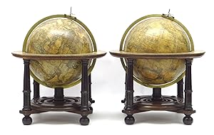
![Seller image for [Pair of nine-inch table globes]. for sale by Daniel Crouch Rare Books Ltd](https://pictures.abebooks.com/inventory/md/md30793851685.jpg)
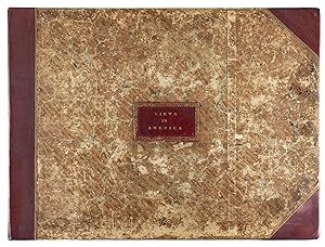


![Seller image for [Terrestrial globe]. In ista quam exhibemus Terreni Globi descriptione omnium regionum juxta et insularum . for sale by Bruce Marshall Rare Books](https://pictures.abebooks.com/inventory/md/md30778535852.jpg)
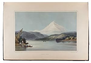
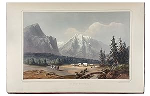
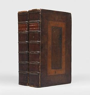
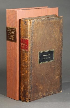
![Seller image for [Six Remarkable Views in the Provinces of New York, New Jersey and Pennsylvania: Engraved after the Paintings made by Mr. Paul Sandby, from the Drawings taken on the spot by his Excellency Governor Pownall] for sale by Donald A. Heald Rare Books (ABAA)](https://pictures.abebooks.com/inventory/md/md30371339490.jpg)