Order Total (1 Item Items):
Shipping Destination:

Speed John 1552 1629 (84 results)
Skip to main search results
Product Type
- All Product Types
- Books (70)
- Magazines & Periodicals
- Comics
- Sheet Music
- Art, Prints & Posters
- Photographs
- Maps (14)
-
Manuscripts &
Paper Collectibles
Condition
- All Conditions
- New
- Used
Binding
Collectible Attributes
- First Edition (5)
- Signed (1)
- Dust Jacket (2)
- Seller-Supplied Images (72)
- Not Printed On Demand
Free Shipping
Seller Location
Seller Rating
-
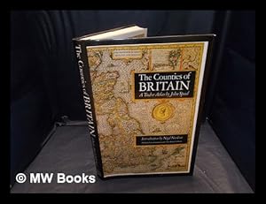
The counties of Britain : a Tudor atlas
Published by London : Pavilion, 1995
ISBN 10: 1857936124ISBN 13: 9781857936124
Book
New edition. Near fine paperback copy; edges very slightly dulled. Remains particularly well-preserved overall; tight, bright, clean and especially sharp-cornered. Physical description: 288 p : ill, maps, ports ; 31 cm. Notes: Previous ed.: 1988. Includes index. Subjects: England; Maps; Great Britain History Elizabeth, 1558-1603; Great Britain History James I, 1603-1625; Early works to 1800; Facsimiles.; Great Britain Description and travel. 1 Kg.
More buying choices from other sellers on AbeBooks
Used offers from � 21.11
-
An atlas of Tudor England and Wales : forty plates from John Speed's pocket atlas of 1627 / described by E.G.R. Taylor
Published by London: Penguin Books, 1951
Reprint. Near fine cloth copy in a near-fine, very slightly edge-nicked and dust-dulled dust-wrapper. Remains particularly well-preserved overall; tight, bright, clean and strong. Physical description; 32 pages : illustrations ; 19 cm. Subjects; Early maps ; Facsimiles. Historical geography ; Maps. Wales Maps ; Early works to 1800. Great Britain History Elizabeth, 1558-1603 ; Maps. 1 Kg.
-

An atlas of Tudor England and Wales : forty plates from John Speed's pocket atlas of 1627 / introduced and described by E.G.R. Taylor
Published by Harmondsworth : Penguin Books, 1951
First Edition
First Edition. Near fine cloth copy in a very good if slightly edge-nicked and dust-dulled dw, now mylar-sleeved. Price-clipped. Previous owner's inscription to ffep. Remains particularly and surprisingly well-preserved overall; tight, bright, clean and strong.; 8vo 8" - 9" tall; 31 pages; Series: King Penguin books ; 61. 31 p., 40 p. of plates : col. maps ; 19 cm. Subjects: Early maps - Facsimiles. England - Maps. Cartography. Great Britain - History - Elizabeth, 1558-1603 - Maps. 1 Kg.
-

An atlas of Tudor England and Wales : forty plates from John Speed's pocket atlas of 1627 / described by E.G.R. Taylor
Published by London: Penguin Books, 1951
Reprint. Near fine cloth copy in a near-fine, very slightly edge-nicked and dust-dulled dust-wrapper. Remains particularly well-preserved overall; tight, bright, clean and strong. Physical description; 32 pages : illustrations ; 19 cm. Subjects; Early maps ; Facsimiles. Historical geography ; Maps. Wales Maps ; Early works to 1800. Great Britain History Elizabeth, 1558-1603 ; Maps. 1 Kg.
-
An atlas of Tudor England and Wales : forty plates from John Speed's pocket atlas of 1627 / introduced and described by E.G.R. Taylor
Published by Harmondsworth : Penguin Books, 1951
First Edition
First Edition. Near fine cloth copy in a very good if slightly edge-nicked and dust-dulled dw, now mylar-sleeved. Price-clipped. Previous owner's inscription to ffep. Remains particularly and surprisingly well-preserved overall; tight, bright, clean and strong.; 8vo 8" - 9" tall; 31 pages; Series: King Penguin books ; 61. 31 p., 40 p. of plates : col. maps ; 19 cm. Subjects: Early maps - Facsimiles. England - Maps. Cartography. Great Britain - History - Elizabeth, 1558-1603 - Maps. 1 Kg.
-
The counties of Britain : a Tudor atlas / by John Speed (1552-1629) ; introduction by Nigel Nicholson ; County commentaries by Alasdair Hawkyard
Published by London : Pavilion in association with British Library, 1988
ISBN 10: 1851451315ISBN 13: 9781851451319
Book First Edition
First Edition. Fine cloth copy in an equally fine dust-wrapper. Particularly well-preserved overall; tight, bright, clean and especially sharp-cornered. Physical description; 288 pages : illustrations (some color), coats of arms, color maps, portraits (some color) ; 31 cm. 1 Kg.
-
An Epitomie of Mr. John Speed's Theatre of the Empire of Great Britain
Published by And are to bee sould by Georg Humble at ye White-horse in popeshead Alley C, 1670
Dis-bound book without the maps. 10.3cm high x 15.5cm long x 2.3cm thick. Landscape format. Rear board and spine still attached. Page signatures begin on A2 and end on Z7. Unfortunately all maps have been removed, so I estimate there are 64 leaves absent. Pages toned. First few leaves (and the last leaves as well), with small edge loss. ** Referenced by: STC (2nd ed.) 23035 / S103213 *** "John Speed (1552?-1629) was one of the most important early English cartographers. His Theatre of the Empire of Great Britaine was first published in 1612 and many times thereafter, both as a folio-sized volume and eventually as a smaller book, called An Epitome of . . . [the] Theatre, easy to hold in the hand or carry in a pouch.
-
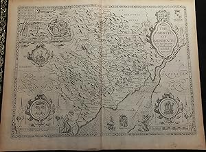
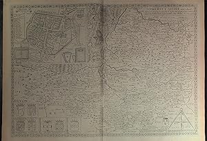
Theatre of the Empire of Great Britaine. "The Countye of Monmouth wih the situation of the Shire-towe Described Ann 160"
Published by London: Bassett & Chiswell, 1676
Single sheet (15 x 20 inches) Full margins showing the plate mark (slight browning to edge, some foxing, light offsetting, creasing) An elegant uncolored map of Monmouthshire; taken from the famous Theatre of the Empire of Great Britaine by English cartographer John Speed. These 17th century plates were engraved in Amsterdam by the great Dutch mapmaker Jodocus Hondius. They exhibit the highest level of craftsmanship and artistic embellishment from the strapwork cartouches, mast ships, Mannerist figures, and striking detailing. A highly mountainous and hilly region, Monmouthshire stretches its borders with several other Shires within Wales. The map dutifully bares two coat of arms: those of the ruling King Charles II; and those of Wales. Each of these arms is beautifully framed in an elegant cartouche. The heraldic badge of the Prince of Wales, represented by three white feathers emerging from a gold coronet, is presented in the lower left corner. The town plan of Monmouth is inset, depicting a bustling town, complete with its coat of arms. A letter guide and key provide a guide to the significant roads and buildings. This plan was mapped by John Speed himself, as indicted by the Scale of Pases and dividers. Monmouth, a traditional county market town within Monmouthshire, was also the birthplace of King Henry V (1387). This is highlighted by a circular frame baring his portrait below the town plan. The 1676 edition also carries some additional shields, most previously printed on some maps. This includes James Scot, 1st Duke of Monmouth (1663); and that of Robert Carey, 1st Earl of Monmouth (1626). The county maps found in the Theatre of the Empire of Great Britaine were the first consistent attempt to show territorial divisions, but it was mainly Speed s town plans that were the major innovation and probably his greatest contribution to British cartography. Together, they formed the first printed collection of town plans of the British Isles and, for at least 50 of the 73 included in the Theatre, it was the first time these towns had been mapped. While being the first English atlas of the British Isles, Speed s Atlas was also one of the first attempts to accurately survey Ireland and to incorporate a comprehensive list of their town plans into the maps. The 1676 edition of Speed's atlas never came with original color. The examples of this map of Monmouthsire should always be uncolored and never colored. Born in Cheshire, John Speed developed his interest in maps in the 1580s, after moving to London to pursue his passions outside of tailoring. He there joined the Society of Antiquaries, where his enthusiasm for cartography won him the attention of William Camden, Robert Cotton, and Sir Fulke Greville. By working with these figures, Speed was able to do a large amount of research for his own work. In 1596, Greville bequeathed Speed with an unlimited allowance to research, and then later write, the Historie of Great Britaine. It was during this project which Speed had the encouragement to add a cartographic supplement to the work what we today know as his most famous atlas. After being first published in 1611-1612, the 'Theatre of Great Britain' dominated the seventeenth-century English map market, going through many reprints and editions. Thanks to the Atlas success, Speed earned the title of England s most well-known Stuart period cartographer and his work became the blueprint for folio atlases until the mid-18th century. Historically, Speed is also noted for placing England into the mainstream of map publishing, which had been dominated by the Dutch since the late sixteenth century. This map of Monmouthsire is an excellent part of the Theatre of the Empire of Great Britaine, and would be an outstanding addition to all map collections. For more information on this map, or a warm welcome to see other maps and books of our collection at 72nd Street NYC, please contact Natalie Zadrozna.
-
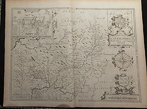
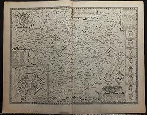
Theatre of the Empire of Great Britaine. Caermarden Both Shyre and Towne described.
Published by London: Bassett & Chiswell, 1676
Single sheet (15 x 20 inches) Full margins showing the plate mark (slight browning to edge, offsetting) This elegant map of Caermarden, taken from the Theatre of the Empire of Great Britaine, is a stunning example of the level of detail and craftsmanship which went into creating this Atlas. Engraved in 1610 on copper plates by renowned Dutch mapmaker Jodocus Hondius, this is one of the finest maps of this county. 'Jodocus Hondius celavit' 'Cum privilegio' The county of Caermarden presents itself in a title cartouche baring the King's royal coat of arms. It stretches its lined borders with parts of Cardigan, Glamorganshire, Breknokshire, and Pembrokshire. The Shire's coat of arms and a compass rose decorate the lower portion of the map, held in a strapwork frame. A desirable element to this map is the inset of Caermarden, known today as Carmarthen. The town is known for being the oldest town in Wales, with the two settlements of Old and New Carmarthen uniting in 1546. "The chief citie of the county" (William Camden) The shield of the town and key guide to the significant roada and building highlight this inset. It is also noteworthy to say this town was mapped out by Speed himself, as indicated by his 'Scale of Pases'. The county maps found in the Theatre of the Empire of Great Britaine were the first consistent attempt to show territorial divisions, but it was mainly Speed's town plans that were the major innovation and probably his greatest contribution to British cartography. Together, they formed the first printed collection of town plans of the British Isles and, for at least 50 of the 73 included in the Theatre, it was the first time these towns had been mapped. While being the first English atlas of the British Isles, Speed's Atlas was also one of the first attempts to accurately survey Ireland and to incorporate a comprehensive list of their town plans into the maps. The 1676 edition of Speed's atlas never came with original color. The examples of this map of Caermarden (Carmarthenshire) should always be uncolored and never colored. Born in Cheshire, John Speed developed his interest in maps in the 1580s, after moving to London to pursue his passions outside of tailoring. He there joined the Society of Antiquaries, where his enthusiasm for cartography won him the attention of William Camden, Robert Cotton, and Sir Fulke Greville. By working with these figures, Speed was able to do a large amount of research for his own work. In 1596, Greville bequeathed Speed with an unlimited allowance to research, and then later write, the Historie of Great Britaine. It was during this project which Speed had the encouragement to add a cartographic supplement to the work - what we today know as his most famous atlas. After being first published in 1611-1612, the 'Theatre of Great Britain' dominated the seventeenth-century English map market, going through many reprints and editions. Thanks to the Atlas' success, Speed earned the title of England's most well-known Stuart period cartographer and his work became the blueprint for folio atlases until the mid-18th century. Historically, Speed is also noted for placing England into the mainstream of map publishing, which had been dominated by the Dutch since the late sixteenth century. This map of Caermarden (Carmarthenshire) is an excellent part of the Theatre of the Empire of Great Britaine, and would be an outstanding addition to all map collections. For more information on this map, or a warm welcome to see other maps and books of our collection at 72nd Street NYC, please contact Natalie Zadrozna.
-
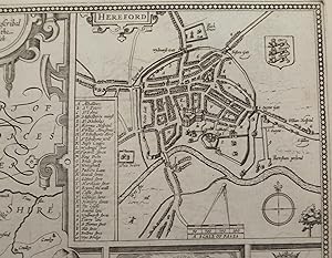
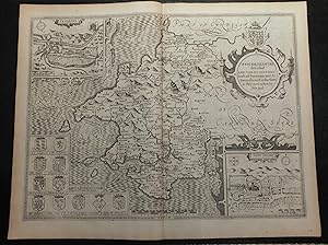
Single sheet (15 x 20 inches) Full margins showing the plate mark (slight browning to edge, good margins) An elaborately decorated and uncolored 1676 edition map of Herefordshire; taken from the Theatre of the Empire of Great Britaine by famous English cartographer John Speed. Engraved by Jocodus Hondius in his Amsterdam workshop in 1610, this map demonstrates the highest level of accuracy, detail, and craftsmanship. This map is particualrily interesting for depicting two cartographers in the lower corners - one holds a globe, the other a pair of dividers. It is assumed that these are the significant individuals tied to the art of mapmaking. Herefordshire is a historic English county in the West Midlands. It's borders touch with those of Shropshire, Worchestershire, Glochestershire, Mounmothshire, and Breknokshire. The landscape of the county is relatively flat; save for a handful of small hills sprinkled around. The town plan of Hereford is found in the right corner. The plan is decorated with the town's coat of arms and a compass rose. Hereford is known as a cathedral city, civil parish, and the county town of Herefordshire; which can be told from the map. The famous Hereford Cathedral, dating back to 1079, sits gallantly in the center of the plan; with a spider web of roads extending from it. Other significant buildings and places are marked by a letter and key guide. It is noteworthy to mention is that this plan was mapped by John Speed himself, as indicated by the 'Scale of Pases' and dividers. A highly sought after feature of Speed's county maps are his inclusions of vignettes showing great English battles and events. The Herefordshire map bears a moment in action of the Battle of Mortimer's Cross in 1461. During the War of the Roses, Owen Tudor, the defeated Lancastrian leader, was taken to Hereford by Sir Roger Vaughan to be executed. As dawn broke, the meteorological phenomenon known as 'parhelion' occurred: three suns were seen to be rising. Edward of York appeared to have convinced the troops that it represented the Holy Trinity and that therefore God was on their side. This event is further articulated in a small frame beneath the vignette. The left side of the map also boasts several coat of arms of the county's ruling Earls and Dukes. The 'Earl of Hereford' is considered one of the first English peerage titles. Notable individuals include: Henry Bullingbrok, 1st Duke of Hereford (1367) and future King Henry IV; William FitzOsbern, 1st Earl of Hereford (1067) and close counselor to William the Conqueror; and Henry Bohun, 1st Earl of Hereford (1199). The county maps found in the Theatre of the Empire of Great Britaine were the first consistent attempt to show territorial divisions, but it was mainly Speed's town plans that were the major innovation and probably his greatest contribution to British cartography. Together, they formed the first printed collection of town plans of the British Isles and, for at least 50 of the 73 included in the Theatre, it was the first time these towns had been mapped. While being the first English atlas of the British Isles, Speed's Atlas was also one of the first attempts to accurately survey Ireland and to incorporate a comprehensive list of their town plans into the maps. The 1676 edition of Speed's atlas never came with original color. The examples of this map of Herefordshire should always be uncolored and never colored. Born in Cheshire, John Speed developed his interest in maps in the 1580s, after moving to London to pursue his passions outside of tailoring. He there joined the Society of Antiquaries, where his enthusiasm for cartography won him the attention of William Camden, Robert Cotton, and Sir Fulke Greville. By working with these figures, Speed was able to do a large amount of research for his own work. In 1596, Greville bequeathed Speed with an unlimited allowance to research, and then later write, the Historie of Great Britaine. It was during this project which Speed.
-
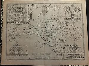
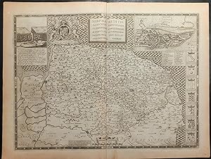
Theatre of the Empire of Great Britaine. "The Countie of Radnor described and they Shyretownes Sittuatione Anno "
Published by London: Bassett & Chiswell, 1676
Single sheet (15 x 20 inches) Full margins showing the plate mark (slight browning to edge, light foxing, offsetting, margin ink smear) This handsome uncolored map of Radnorshire is one of the finest examples available of the county. Taken from the Theatre of the Empire of Great Britaine by English cartographer John Speed. The copper plates were engraved by renowned Dutch mapmaker, Jodocus Honius in 1610, Amsterdam. The maps from this famous Atlas are highly sought after for their stunning accuracy, detailing, and decorations. Radnorshire is a prime example of these claims. The historic county is bounded to the north by Montgomeryshire and Shropshire, to the east by Herefordshire, to the south by Brecknockshire and to the west by Cardiganshire.Hondius engraving takes careful care in depicting the hilly landscape of the county, filled with flowing rivers, bright blue lakes, and fenced parks. The map exhibits several coat of arms relating to the Shire. The grandest being the royal arms of King Charles II, beautifully embellished and framed. The arms of Wales are represented below, with the heraldic badge of the Prince of Wales centered. The town plan of Radnor is inset at the left corner. Though the town itself of smaller size, it s shield, Castle and Abbey appear to tower over the homes engraved below. It is worth noting that this plan was mapped out by John Speed himself, as indicated by this signature Scale of Pases . The county maps found in the Theatre of the Empire of Great Britaine were the first consistent attempt to show territorial divisions, but it was mainly Speed s town plans that were the major innovation and probably his greatest contribution to British cartography. Together, they formed the first printed collection of town plans of the British Isles and, for at least 50 of the 73 included in the Theatre, it was the first time these towns had been mapped. While being the first English atlas of the British Isles, Speed s Atlas was also one of the first attempts to accurately survey Ireland and to incorporate a comprehensive list of their town plans into the maps. The 1676 edition of Speed's atlas never came with original color. The examples of this map of Radnorshire should always be uncolored and never colored. Born in Cheshire, John Speed developed his interest in maps in the 1580s, after moving to London to pursue his passions outside of tailoring. He there joined the Society of Antiquaries, where his enthusiasm for cartography won him the attention of William Camden, Robert Cotton, and Sir Fulke Greville. By working with these figures, Speed was able to do a large amount of research for his own work. In 1596, Greville bequeathed Speed with an unlimited allowance to research, and then later write, the Historie of Great Britaine. It was during this project which Speed had the encouragement to add a cartographic supplement to the work what we today know as his most famous atlas. After being first published in 1611-1612, the 'Theatre of Great Britain' dominated the seventeenth-century English map market, going through many reprints and editions. Thanks to the Atlas success, Speed earned the title of England s most well-known Stuart period cartographer and his work became the blueprint for folio atlases until the mid-18th century. Historically, Speed is also noted for placing England into the mainstream of map publishing, which had been dominated by the Dutch since the late sixteenth century. This map of Radnorshire is an excellent part of the Theatre of the Empire of Great Britaine, and would be an outstanding addition to all map collections. For more information on this map, or a warm welcome to see other maps and books of our collection at 72nd Street NYC, please contact Natalie Zadrozna.
-
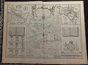
Theatre of the Empire of Great Britaine. "Huntington both Shire and Shire towne with the ancient citie ely described"
Published by London: Bassett & Chiswell, 1676
Single sheet (15 x 20 inches) Full margins showing the plate mark (slight browning to edge, light foxing, offsetting, ink spot centre crease) A handsome map of Huntingtonshire; taken from the famous Theatre of the Empire of Great Britaine by English cartographer John Speed. Engraved by Jodocus Hondius in 1610, this county map is the best of its kind. It is highly sought after for it level of accuracy, detail, and craftsmanship. There are no finer county maps on the market. Huntingtonshire is beautifully introduced to us in a title cartouche, flanked by two hunters and a stag; representing the hunting county which it is known for. The map further shows the series of fenced parks, tress, forests, and lakes. Two open books sit on opposite sides, telling the story of Huntington's noble history; the other recounts the significance of including the Isle of Ely in this map (despite being a part of Cambridgeshire). The most important ruling Dukes and Earls are represented here by a series of coat of arms; notably including those of George Hastings and Henry, Prince of Scotland. The King's coat of arms is shown above the Scale of Miles. The town plans of Huntington and Ely are inset within in map, mirroring one another. Huntington, a market and county town of Huntingtonshire, dates back to the Anglo-Saxons and Danes. It is a frequent hunting and trading ground for the people, and well-represented in this map thanks to the pastoral activity in the landscape. Ely, better known as Isle of Ely, is a famous cathedral city in Cambridgeshire, due to the epic Ely Catherdal. The city has always been supported by royal families; such as King Henry VIII who granted a boarding school charter. Both of these plan were mapped by John Speed, as indicated by the 'Scale of Pases'. The county maps found in the Theatre of the Empire of Great Britaine were the first consistent attempt to show territorial divisions, but it was mainly Speed's town plans that were the major innovation and probably his greatest contribution to British cartography. Together, they formed the first printed collection of town plans of the British Isles and, for at least 50 of the 73 included in the Theatre, it was the first time these towns had been mapped. While being the first English atlas of the British Isles, Speed's Atlas was also one of the first attempts to accurately survey Ireland and to incorporate a comprehensive list of their town plans into the maps. The 1676 edition of Speed's atlas never came with original color. The examples of this map of Huntingtonshire should always be uncolored and never colored. Born in Cheshire, John Speed developed his interest in maps in the 1580s, after moving to London to pursue his passions outside of tailoring. He there joined the Society of Antiquaries, where his enthusiasm for cartography won him the attention of William Camden, Robert Cotton, and Sir Fulke Greville. By working with these figures, Speed was able to do a large amount of research for his own work. In 1596, Greville bequeathed Speed with an unlimited allowance to research, and then later write, the Historie of Great Britaine. It was during this project which Speed had the encouragement to add a cartographic supplement to the work - what we today know as his most famous atlas. After being first published in 1611-1612, the 'Theatre of Great Britain' dominated the seventeenth-century English map market, going through many reprints and editions. Thanks to the Atlas' success, Speed earned the title of England's most well-known Stuart period cartographer and his work became the blueprint for folio atlases until the mid-18th century. Historically, Speed is also noted for placing England into the mainstream of map publishing, which had been dominated by the Dutch since the late sixteenth century. This map of Huntingtonshire is an excellent part of the Theatre of the Empire of Great Britaine, and would be an outstanding addition to all map collections. For more information on th.
-
Theatre of the Empire of Great Britaine. "Rutlandshire with Oukham and Stanford her_ bordering Neighbor Newely described".
Published by London: Bassett & Chiswell, 1676
Single sheet (15 x 20 inches) Full margins showing the plate mark (slight browning to edge, light foxing, offsetting, ink spot centre crease) An elegant map of Rutlandshire; taken from the famous Theatre of the Empire of Great Britaine by English cartographer John Speed. Engraved by Jodocus Hondius in 1610, this county map is the best of its kind. It is highly sought after for it level of accuracy, detail, and craftsmanship. There are no finer county maps on the market. The county is introduced to us in a title cartouche, embellished with cranes, lobsters, and the county shield. Rutland is depicted as a landlocked county in the East Midlands of England; bounded to the west and north by Leicestershire, to the northeast by Lincolnshire and the southeast by Northamptonshire. It is the smallest historic county in England. The land shows few towns, and is rather left to the imagination for it's handsome forests, parks, and hills. The town plans of Oukham and Stanford mirror one another on opposing ends of the map. The town of Oukham is shown as a simple market town. Only the great hall of the Norman castle in Oukham is still standing, and is surrounded by steep earthworks marking the inner bailey. The hall dates from c. 1180-90. "It is the earliest hall of any English castle surviving so completely, and it is doubly interesting in that it belonged not to a castle strictly speaking, but rather to a fortified manor house." (Pevsner) The shield of Oukham decorates the upper corner. The symbol of the horseshoe on the shield is significant. Traditionally, members of royalty and peers of the realm who visited or passed through the town had to pay a forfeit in the form of a horseshoe. The town of Stanfort is represented as more bustling, with abbeys, small castles, and churches. Both of these plans were mapped by John Speed, as indicated by the 'Scale of Pases'. The final detail touches by Hondius includes a selection of coat of arms belonging to local ruling Earls and Dukes; an elaborate compass rose; cherubim; and the arms of the royal King. The county maps found in the Theatre of the Empire of Great Britaine were the first consistent attempt to show territorial divisions, but it was mainly Speed's town plans that were the major innovation and probably his greatest contribution to British cartography. Together, they formed the first printed collection of town plans of the British Isles and, for at least 50 of the 73 included in the Theatre, it was the first time these towns had been mapped. While being the first English atlas of the British Isles, Speed's Atlas was also one of the first attempts to accurately survey Ireland and to incorporate a comprehensive list of their town plans into the maps. The 1676 edition of Speed's atlas never came with original color. The examples of this map of Rutlandshire should always be uncolored and never colored. Born in Cheshire, John Speed developed his interest in maps in the 1580s, after moving to London to pursue his passions outside of tailoring. He there joined the Society of Antiquaries, where his enthusiasm for cartography won him the attention of William Camden, Robert Cotton, and Sir Fulke Greville. By working with these figures, Speed was able to do a large amount of research for his own work. In 1596, Greville bequeathed Speed with an unlimited allowance to research, and then later write, the Historie of Great Britaine. It was during this project which Speed had the encouragement to add a cartographic supplement to the work - what we today know as his most famous atlas. After being first published in 1611-1612, the 'Theatre of Great Britain' dominated the seventeenth-century English map market, going through many reprints and editions. Thanks to the Atlas' success, Speed earned the title of England's most well-known Stuart period cartographer and his work became the blueprint for folio atlases until the mid-18th century. Historically, Speed is also noted for placing England into the mainst.
-
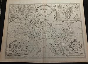
Single sheet (15 x 20 inches) Full margins showing the plate mark (slight browning to edge, foxing, crease centerfold affecting letter 'B'). A highly decorative map of Denbighshire by one of the greatest English cartographers, John Speed. This map is an element from Speed's famous Theatre of the Empire of Great Britaine. Engraved on copper plates in Amsterdam by renowned Jodocus Hondius, this is one of the finest maps of the county. Denbighshire, clearly a mountainous region, was surveyed by Christopher Saxton and Speed's source for this map. The county stretches its borders with Flintshire, Carnavanshire, Meryonethshire, Cheshire, and Shrotshire. The Sea is also beautifully depicted and decorated with Poseidon, sea monsters, and a ship. The town plan of Denbigh sits in the right corner of the map and illustrates the castle and the vibrant, small settlement that grew up around it. The highlighted buildings, churches, and squares are guided by a letter to use with the corresponding key. This is one of the selections of towns which was mapped by John Speed himself, as indicated by the 'Scale of Pases'. A small circular inset displaying a castle built by King Edward I in 1282, and abandoned to ruin in 1660. The map hosts several coat of arms. The royal coat of arms of the King sit gallantly over the map's Scale of Miles; alongside those arms we also find those of Robert Dudley, Lord of Denbigh and Earl of Leicester, a favorite friend of Queen Elizabeth; and of William Feilding, Earl of Denbigh, Master of the Great Wardrobe under King James I. The shield of Denbigh is royally framed The county maps found in the Theatre of the Empire of Great Britaine were the first consistent attempt to show territorial divisions, but it was mainly Speed's town plans that were the major innovation and probably his greatest contribution to British cartography. Together, they formed the first printed collection of town plans of the British Isles and, for at least 50 of the 73 included in the Theatre, it was the first time these towns had been mapped. While being the first English atlas of the British Isles, Speed's Atlas was also one of the first attempts to accurately survey Ireland and to incorporate a comprehensive list of their town plans into the maps. The 1676 edition of Speed's atlas never came with original color. The examples of this map of the Denbighshire should always be uncolored and never colored. Born in Cheshire, John Speed developed his interest in maps in the 1580s, after moving to London to pursue his passions outside of tailoring. He there joined the Society of Antiquaries, where his enthusiasm for cartography won him the attention of William Camden, Robert Cotton, and Sir Fulke Greville. By working with these figures, Speed was able to do a large amount of research for his own work. In 1596, Greville bequeathed Speed with an unlimited allowance to research, and then later write, the Historie of Great Britaine. It was during this project which Speed had the encouragement to add a cartographic supplement to the work - what we today know as his most famous atlas. After being first published in 1611-1612, the 'Theatre of Great Britain' dominated the seventeenth-century English map market, going through many reprints and editions. Thanks to the Atlas' success, Speed earned the title of England's most well-known Stuart period cartographer and his work became the blueprint for folio atlases until the mid-18th century. Historically, Speed is also noted for placing England into the mainstream of map publishing, which had been dominated by the Dutch since the late sixteenth century. This map of Denbighshire is an excellent part of the Theatre of the Empire of Great Britaine, and would be an outstanding addition to all map collections. For more information on this map, or a warm welcome to see other maps and books of our collection at 72nd Street NYC, please contact Natalie Zadrozna.
-
Theatre of the Empire of Great Britaine. "Cardigan Shyre Described with the due forme of the Shiretown as it was surveryed by I.S. Anno 160"
Published by London: Bassett & Chiswell, 1676
Map
No Binding. Condition: Very Good. Single sheet (15 x 20 inches) Full margins showing the plate mark (slight browning to edge, light foxing, 5." tear left page, offsetting) An elegant uncolored 1676 edition map of Cardiganshire; taken from the Theatre of the Empire of Great Britaine by English cartographer John Speed. Engraved by Jodocus Hondius in 1610 in Amsterdam, this county map is the most highly sought after county maps as they are famous for their accuracy, level of detail, and craftsmanship. Cardiganshire is one of the thirteen original counties of Wales, and it is also one of the more significant ones. This land itself dates back to prehistoric times; with several standing stones dating back to the Bronze Age. In the time of the 15-16th century, many pilgrims passed through Cardiganshire on their way to St Davids and its sacred bathes. Some came by sea and made use of the churches, while others came by land seeking hospitality at such places as Strata Florida Abbey. Both the abbey and Llanbadarn Fawr were important monastic sites of scholarship and education. Hondius choice in the engraving of this map does not limit itself to simple detail. Every space on the map is filled with hills, sea monsters, ship, or elegant cartouches holding the title, compass, or Scale of Miles . There is also a level of symmetry found in this map; creating a delight for the eyes. A particularly attractive detail to this map is the cunning use of the compass rose to hold the heraldic badge of the Prince of Wales. Included in this map is also the shield of Thomas Brudenell, 1st Earl of Cardigan (1661); it was not typically not printed in earlier editions. The town inset of Cardigan shown on this map does a good job in representing the significant places the town is known for. The plan is embellished with its coat of arms, a elegantly simply compass rose, and gorgeous landscape surrounding the town. It is noteworthy that these plans were mapped by John Speed himself; indicated by his signature Scale of Pases . The county maps found in the Theatre of the Empire of Great Britaine were the first consistent attempt to show territorial divisions, but it was mainly Speed s town plans that were the major innovation and probably his greatest contribution to British cartography. Together, they formed the first printed collection of town plans of the British Isles and, for at least 50 of the 73 included in the Theatre, it was the first time these towns had been mapped. While being the first English atlas of the British Isles, Speed s Atlas was also one of the first attempts to accurately survey Ireland and to incorporate a comprehensive list of their town plans into the maps. The 1676 edition of Speed's atlas never came with original color. The examples of this map of Cardiganshire should always be uncolored. Born in Cheshire, John Speed developed his interest in maps in the 1580s, after moving to London to pursue his passions outside of tailoring. He there joined the Society of Antiquaries, where his enthusiasm for cartography won him the attention of William Camden, Robert Cotton, and Sir Fulke Greville. By working with these figures, Speed was able to do a large amount of research for his own work. In 1596, Greville bequeathed Speed with an unlimited allowance to research, and then later write, the Historie of Great Britaine. It was during this project which Speed had the encouragement to add a cartographic supplement to the work what we today know as his most famous atlas. After being first published in 1611-1612, the 'Theatre of Great Britain' dominated the seventeenth-century English map market, going through many reprints and editions. Thanks to the Atlas success, Speed earned the title of England s most well-known Stuart period cartographer and his work became the blueprint for folio atlases until the mid-18th century. Historically, Speed is also noted for placing England into the mainstream of map publishing, which had been dominated by the Dutch.
-
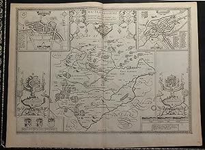
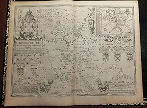
Single sheet (15 x 20 inches) Full margins showing the plate mark (slight browning to edge, good margins) An elegant uncolored 1676 edition county map of Bedford Shire; taken from the highly acclaimed Theatre of the Empire of Great Britaine by English cartographer John Speed. Engraved by Jodocus Hondius, these maps are lauded for their high level of accuracy, detail, and craftsmanship. This is considered one of the finest maps depicting Bedfordshire available today. A decorative cartouche bearing the King's coat of arms and the title, cherubim, dividers - we already have a taste of the elaborate features. The county is bordered by Cambridgeshire, Northamptonshire, Hertfordshire, and Buckinghamshire The town plan of Bedforde is inset by the right hand corner, held by a Roman general. The map is decorated by a small title cartouche-like coat of arms and a simple compass rose. The town is most well-known for St. Paul's Church, engraved central on the map. The town's other significant roads and buildings are marked by a letter and guide for facilitated reference. It is noteworthy to mention this plan was mapped by John Speed himself, as indicated by his signature scale of 'Pases'. The map is further embellished with the shields of several Earls and Dukes. Notable individuals include: John Plantaginet (Lancaster), 1st Duke of Bedford (14140 and brother of King Henry V; Ingelram Coucy, 1st Earl of Bedford (1366) and son-in-law to King Edward III; and John Russell, 1st Earl of Bedford (1550). Small framed text tells the 1399 event of the River Ouse flooding and straying its course. As a result, it divided the towns and county. This was deemed a foreshadowing of the War of the Roses, which occurred a short while afterwards. The county maps found in the Theatre of the Empire of Great Britaine were the first consistent attempt to show territorial divisions, but it was mainly Speed's town plans that were the major innovation and probably his greatest contribution to British cartography. Together, they formed the first printed collection of town plans of the British Isles and, for at least 50 of the 73 included in the Theatre, it was the first time these towns had been mapped. While being the first English atlas of the British Isles, Speed's Atlas was also one of the first attempts to accurately survey Ireland and to incorporate a comprehensive list of their town plans into the maps. The 1676 edition of Speed's atlas never came with original color. The examples of this map of Beford Shire should always be uncolored and never colored. Born in Cheshire, John Speed developed his interest in maps in the 1580s, after moving to London to pursue his passions outside of tailoring. He there joined the Society of Antiquaries, where his enthusiasm for cartography won him the attention of William Camden, Robert Cotton, and Sir Fulke Greville. By working with these figures, Speed was able to do a large amount of research for his own work. In 1596, Greville bequeathed Speed with an unlimited allowance to research, and then later write, the Historie of Great Britaine. It was during this project which Speed had the encouragement to add a cartographic supplement to the work - what we today know as his most famous atlas. After being first published in 1611-1612, the 'Theatre of Great Britain' dominated the seventeenth-century English map market, going through many reprints and editions. Thanks to the Atlas' success, Speed earned the title of England's most well-known Stuart period cartographer and his work became the blueprint for folio atlases until the mid-18th century. Historically, Speed is also noted for placing England into the mainstream of map publishing, which had been dominated by the Dutch since the late sixteenth century. This map of Bedford Shire is an excellent part of the Theatre of the Empire of Great Britaine, and would make an outstanding addition to all map collections. For more information on this map, or a warm welcome to see other map.
-
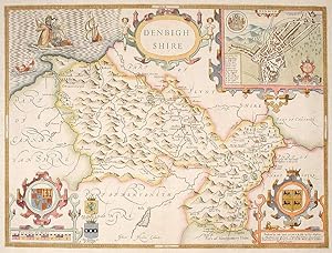
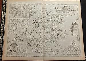
Denbighshire
Published by Henry Overton, Bassett & Chiswell, London, 1713
Seller: Donald A. Heald Rare Books (ABAA), New York, NY, U.S.A.
Seller Rating:

Map
Copper-engraved map, with full modern colour, very large marings, in very good condition, except for a stain at the bottom edge, well away from the image. A highly decorative map of Denbighshire by one of the greatest English cartographers Denbighshire in Wales, clearly a mountainous region, was surveyed by Christopher Saxton, which was Speed's source for this map. William Smith, Pursuivant at the College of Arms, was the apparent source for the coats of arms: one of which is that of Robert Dudley, Earl of Leicester, Queen Elizabeth's favorite. In the town plan of Denbigh, in the upper right corner is a circular inset displaying what appears to be a castle. It is actually an unfinished and indeed never finished church that Leicester had tried to have built in Denbigh. Apparently, his unpopularity was part of the reason the church was never completed. The map is decorated with a sea monster, a classical god on horseback, and a ship. Henry Overton's edition of this map includes the few roads that snaked their way through the county. cf. Hawkyard and Nicolson, The Counties of Britain A Tudor Atlas by John Speed, p. 73-76; Skelton, The County Atlases of the British Isles 1579-1850, Map Collector's Circle, part 1, #7 Speed and part 4, #92 & 121.
-
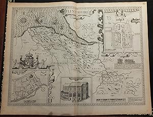
Single sheet (15 x 20 inches) Full margins showing the plate mark (slight browning to edge, crease centerfold). A superb uncolored map of Flintshire, taken from John Speed's famous Theatre of the Empire of Great Britaine. Engraved on copper plates in Amsterdam by renowned Jodocus Hondius, this is one of the most decorative maps of the county. Hondius makes excellent use of space in his engravings of the county; filling any blank spaces of the sea with sea monsters, full mast ships, and an elegant compass rose. The map is embellished with three insets; two of which are the town plans of Flint and of Saint Asaph. It is noteworthy to mention that these two plans were mapped by Speed himself, as indicated by the 'Scale of Pases'. The third inset is an enlarged illustration of St. Winefride's Well. The building gets its name from the healing waters have been said to cause miraculous cures. The legend of Saint Winifred tells how, in AD 660, Caradoc, the son of a local prince, severed the head of the young Winifred after she spurned his advances. A spring rose from the ground at the spot where her head fell and she was later restored to life by her uncle, Saint Beuno. It is claimes to be the oldest continually visited pilgrimage sites. A highly desirable element of Speed's maps is his depiction of important events of British history in vignettes. Here we can see a moment of action during the end of Richard II's reign as he is betrayed into the hands of Henry Bullingbrook. It is dated as '1400 Febr. 13', marking the king's death. The county maps found in the Theatre of the Empire of Great Britaine were the first consistent attempt to show territorial divisions, but it was mainly Speed's town plans that were the major innovation and probably his greatest contribution to British cartography. Together, they formed the first printed collection of town plans of the British Isles and, for at least 50 of the 73 included in the Theatre, it was the first time these towns had been mapped. While being the first English atlas of the British Isles, Speed's Atlas was also one of the first attempts to accurately survey Ireland and to incorporate a comprehensive list of their town plans into the maps. The 1676 edition of Speed's atlas never came with original color. The examples of this map of the Flintshire should always be uncolored and never colored. Born in Cheshire, John Speed developed his interest in maps in the 1580s, after moving to London to pursue his passions outside of tailoring. He there joined the Society of Antiquaries, where his enthusiasm for cartography won him the attention of William Camden, Robert Cotton, and Sir Fulke Greville. By working with these figures, Speed was able to do a large amount of research for his own work. In 1596, Greville bequeathed Speed with an unlimited allowance to research, and then later write, the Historie of Great Britaine. It was during this project which Speed had the encouragement to add a cartographic supplement to the work - what we today know as his most famous atlas. After being first published in 1611-1612, the 'Theatre of Great Britain' dominated the seventeenth-century English map market, going through many reprints and editions. Thanks to the Atlas' success, Speed earned the title of England's most well-known Stuart period cartographer and his work became the blueprint for folio atlases until the mid-18th century. Historically, Speed is also noted for placing England into the mainstream of map publishing, which had been dominated by the Dutch since the late sixteenth century. This map of Flintshire is an excellent part of the Theatre of the Empire of Great Britaine, and would be an outstanding addition to all map collections. For more information on this map, or a warm welcome to see other maps and books of our collection at 72nd Street NYC, please contact Natalie Zadrozna.
-
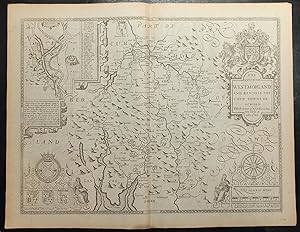
Theatre of the Empire of Great Britaine. The Countie Westmorland and Kendale the Cheif Towne Described With the Armes of Such Nobles as have bene Earles of either of them.
Published by London: Bassett & Chiswell, 1676
Single sheet (15 x 20 inches) Full margins showing the plate mark (slight browning to edge). This superb county map of Westmorland delights the eyes with its elegance and detail. It is a stunning part of John Speed's famous Theatre of the Empire of Great Britaine. The plate was engraved in Amsterdam by the great Dutch mapmaker Jodocus Hondius and the map exhibit the highest level of craftsmanship and artistic embellishment, reflecting the pervasive and appealing Mannerist style of the period, with strapwork cartouches, heraldic crests, and figures. The accuracy and detail of Speed's county maps is what makes them so highly desirable. The title cartouche presents itself nobly with the coat of arms of King Charles II. This smaller county of Britain stretches its borders with Cumberland, Yorkshire, and Lancashire. The town plan of Kendale is characterized on the left portion of the map. Kendale's homes, fortresses, and halls are met with a quaint pastoral background. A letter guide marks the significant roads and buildings of the town. A small framed story describes Malcolm King of Scots' rampage of the Westmorland country side and his marriage to Margaret of Saxony shortly before the successful unification efforts of King James. The Earls showcased below also include the arms of John de Foix, the 1st Earl of Kendal The shield of Ralph Neville, the 1st Earl of Westmorland, is singled out and highlighted, for his role as ally to the ruling Kings of England during his lifetime. The county maps found in the Theatre of the Empire of Great Britaine were the first consistent attempt to show territorial divisions, but it was mainly Speed's town plans that were the major innovation and probably his greatest contribution to British cartography. Together, they formed the first printed collection of town plans of the British Isles and, for at least 50 of the 73 included in the Theatre, it was the first time these towns had been mapped. While being the first English atlas of the British Isles, Speed's Atlas was also one of the first attempts to accurately survey Ireland and to incorporate a comprehensive list of their town plans into the maps. The 1676 edition of Speed's atlas never came with original color. The examples of this map of Westmorland should always be left uncolored and never colored. Born in Cheshire, John Speed developed his interest in maps in the 1580s, after moving to London to pursue his passions outside of tailoring. He there joined the Society of Antiquaries, where his enthusiasm for cartography won him the attention of William Camden, Robert Cotton, and Sir Fulke Greville. By working with these figures, Speed was able to do a large amount of research for his own work. In 1596, Greville bequeathed Speed with an unlimited allowance to research, and then later write, the Historie of Great Britaine. It was during this project which Speed had the encouragement to add a cartographic supplement to the work - what we today know as his most famous atlas. After being first published in 1611-1612, the 'Theatre of Great Britain' dominated the seventeenth-century English map market, going through many reprints and editions. Thanks to the Atlas' success, Speed earned the title of England's most well-known Stuart period cartographer and his work became the blueprint for folio atlases until the mid-18th century. Historically, Speed is also noted for placing England into the mainstream of map publishing, which had been dominated by the Dutch since the late sixteenth century. This map of Westmorland is an excellent part of the Theatre of the Empire of Great Britaine, and would be an outstanding addition to all map collections. For more information on this map, or a warm welcome to see other maps and books of our collection at 72nd Street NYC, please contact Natalie Zadrozna.
-
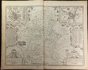
Theatre of the Empire of Great Britaine. Stafford Countie And Towne with the ancient Citie Lichfield described.
Published by London: Bassett & Chiswell, 1676
Single sheet (15 x 20 inches) Full margins showing the plate mark (slight browning to edge, watermark, light spots in centerfold). This stunning uncolored map of Stafford is a part of John Speed's Theatre of the Empire of Great Britaine. The plate was engraved in Amsterdam by the great Dutch mapmaker Jodocus Hondius, exhibiting the highest level of craftsmanship and artistic embellishment. Hondius played with elements of symmetry in engraving this map; as seen by the aligning framed town insets, descriptions, and cartouches. This map boasts two town plans, Stafford and Lichfield. The latter was mapped out by John Speed himself, as indicated by the 'Pases' banner. Each town plan comes complete with their arms, a compass rose, and letter key to guide our understanding of the significant roads and buildings in each. A highly sought after detail of Speed's maps are his vignettes depicting great English battles. This map offers us the Battle of Blore Heath, one of the first major battles in the Wars of the Roses. It was fought on 23 September 1459 in Staffordshire. The story behind the Blore Heath is neatly framed. The final strapwork frame holds the first royal arms of Stafford. "This baronye of Staffor is very anciet and hath bene Earldom, the Nobles wherefod hath borne the title of Dukes of Buckingham". The county maps found in the Theatre of the Empire of Great Britaine were the first consistent attempt to show territorial divisions, but it was mainly Speed's town plans that were the major innovation and probably his greatest contribution to British cartography. Together, they formed the first printed collection of town plans of the British Isles and, for at least 50 of the 73 included in the Theatre, it was the first time these towns had been mapped. While being the first English atlas of the British Isles, Speed's Atlas was also one of the first attempts to accurately survey Ireland and to incorporate a comprehensive list of their town plans into the maps. The 1676 edition of Speed's atlas never came with original color. The examples of this map of Stafford should always be left uncolored and never colored. Born in Cheshire, John Speed developed his interest in maps in the 1580s, after moving to London to pursue his passions outside of tailoring. He there joined the Society of Antiquaries, where his enthusiasm for cartography won him the attention of William Camden, Robert Cotton, and Sir Fulke Greville. By working with these figures, Speed was able to do a large amount of research for his own work. In 1596, Greville bequeathed Speed with an unlimited allowance to research, and then later write, the Historie of Great Britaine. It was during this project which Speed had the encouragement to add a cartographic supplement to the work - what we today know as his most famous atlas. After being first published in 1611-1612, the 'Theatre of Great Britain' dominated the seventeenth-century English map market, going through many reprints and editions. Thanks to the Atlas' success, Speed earned the title of England's most well-known Stuart period cartographer and his work became the blueprint for folio atlases until the mid-18th century. Historically, Speed is also noted for placing England into the mainstream of map publishing, which had been dominated by the Dutch since the late sixteenth century. This map of Stafford is an excellent part of the Theatre of the Empire of Great Britaine, and would be an outstanding addition to all map collections. For more information on this map, or a warm welcome to see other maps and books of our collection at 72nd Street NYC, please contact Natalie Zadrozna.
-
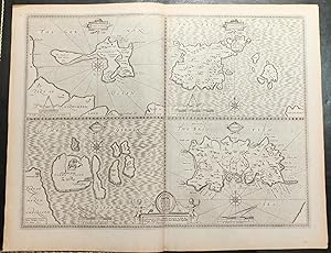
Theatre of the Empire of Great Britaine. The Islands: Holy Iland, Farne, Garnsey, Jarsey
Published by London:Bassett & Chiswell, 1676
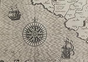
"Single sheet (15 x 20 inches) Full margins showing the plate mark (slight browning to edge). An excellent map by John Speed of the English Islands of: Farne and Holy Island, off the Northumbrian coast; and the Channel Islands of Jersey and Guernsey. This map is a part of the highly regarded Theatre of the Empire of Great Britaine. It was elaborated engraved by Jodocus Hondius in his workshop in Amsterdam in 1610. "Jodocus Hondius celavit_Anno 1610" The Islands is a prime example of the level of craft and detail found in Speed's Atlas. Each quartered map is decorated with small title cartouche, a compass rose, dividers and a mileage scale. The Islands themselves are detailed with significant buildings, fortresses, and windmills. The German Ocean and British Sea surround these islands. The coat of arms of Charles I as Duke of York are found at the bottom of the page, flanked by early revival putti and framed with light fretwork. The Holy Island was made by James Burnell; otherwise "Performed by Iohn Speede. [ ]" The 1676 edition of Speed's atlas never came with original color. The uncolored editions of Speed's maps are classic and highly sought after, as they reflect the true quality of Speed's work unhindered by colorists. The examples of this map of the Islands should always be uncolored and never colored. Born in Cheshire, John Speed developed his interest in maps in the 1580s, after moving to London to pursue his passions outside of tailoring. He there joined the Society of Antiquaries, where his enthusiasm for cartography won him the attention of William Camden, Robert Cotton, and Sir Fulke Greville. By working with these figures, Speed was able to do a large amount of research for his own work. In 1596, Greville bequeathed Speed with an unlimited allowance to research, and then later write, the Historie of Great Britaine. It was during this project which Speed had the encouragement to add a cartographic supplement to the work - what we today know as his most famous atlas. After being first published in 1611-1612, the 'Theatre of Great Britain' dominated the seventeenth-century English map market, going through many reprints and editions. Thanks to the Atlas' success, Speed earned the title of England's most well-known Stuart period cartographer and his work became the blueprint for folio atlases until the mid-18th century. Historically, Speed is also noted for placing England into the mainstream of map publishing, which had been dominated by the Dutch since the late sixteenth century. This map of the Islands is an excellent part of the Theatre of the Empire of Great Britaine, and would be an outstanding addition to all map collections. For more information on this map, or a warm welcome to see other maps and books of our collection at 72nd Street NYC, please contact Natalie Zadrozna.".
-
Theatre of the Empire of Great Britaine. "Merionethshire Described 1610"
Published by London: Bassett & Chiswell, 1676
Single sheet (15 x 20 inches) Full margins showing the plate mark (slight browning to edge, light foxing, offsetting) A stunning county map of Merionethshire; part of the renowned Theatre of the Empire of Great Britaine by English cartographer John Speed. The copper plates were engraved by Jocodus Hondius in 1610, Amsterdam. The maps from this Atlas are highly sought after, due to their intricate accuracy, detailing, and embellishments; with this county map being a prime example of these claims. Hondius engraved this map with plays on symmetry, from the cartouches and framed coat of arms of Wales and King Charles II. The dividers and compass rose are elegant details alongside the winged cherubim flanking both ends of the frame. An inset of Harlech Castle is framed. This impressive castle is a medieval fortification, constructed atop a spur of rock close to the Irish Sea, built by Edward I during his invasion of Wales between 1282 and 1289. Over the next few centuries, the castle played an important part in several wars most notably during the English Civil War where it became the last fortification to surrender to the Parliamentary armies in 1647. The county maps found in the Theatre of the Empire of Great Britaine were the first consistent attempt to show territorial divisions, but it was mainly Speed s town plans that were the major innovation and probably his greatest contribution to British cartography. Together, they formed the first printed collection of town plans of the British Isles and, for at least 50 of the 73 included in the Theatre, it was the first time these towns had been mapped. While being the first English atlas of the British Isles, Speed s Atlas was also one of the first attempts to accurately survey Ireland and to incorporate a comprehensive list of their town plans into the maps. The 1676 edition of Speed's atlas never came with original color. The examples of this map of Merionethshire should always be uncolored and never colored. Born in Cheshire, John Speed developed his interest in maps in the 1580s, after moving to London to pursue his passions outside of tailoring. He there joined the Society of Antiquaries, where his enthusiasm for cartography won him the attention of William Camden, Robert Cotton, and Sir Fulke Greville. By working with these figures, Speed was able to do a large amount of research for his own work. In 1596, Greville bequeathed Speed with an unlimited allowance to research, and then later write, the Historie of Great Britaine. It was during this project which Speed had the encouragement to add a cartographic supplement to the work what we today know as his most famous atlas. After being first published in 1611-1612, the 'Theatre of Great Britain' dominated the seventeenth-century English map market, going through many reprints and editions. Thanks to the Atlas success, Speed earned the title of England s most well-known Stuart period cartographer and his work became the blueprint for folio atlases until the mid-18th century. Historically, Speed is also noted for placing England into the mainstream of map publishing, which had been dominated by the Dutch since the late sixteenth century. This map of Merionethshire is an excellent part of the Theatre of the Empire of Great Britaine, and would be an outstanding addition to all map collections. For more information on this map, or a warm welcome to see other maps and books of our collection at 72nd Street NYC, please contact Natalie Zadrozna.
-
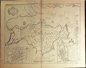
Theatre of the Empire of Great Britaine. County Map of Hampshire: Isle of Wight
Published by London: Bassett & Chiswell, 1676
Single sheet (15 x 20 inches) Full margins showing the plate mark (watermark at middle top, slight browning and foxing to edge). A beautiful map showcasing the Isle of Wight, part of the county of Hampshire. The Isle is shown surrounded by the British Ocean, with a part of England at the map's left-hand corner. Engraved by Jodocus Hondius in his workshop in Amsterdam in 1610, this map is a prime example of the level of craft and detail found in the Theatre of the Empire of Great Britaine. Hondius leaves no part of this stunning map uncovered; the British Ocean can be seen decorated with waves, ships, and sea monsters to make the best use of space. The Isle of Wight is elaborately decorated and filled with rolling hills, trees, and windmills. Most, but not all, of the county maps have town plans on them; those showing a 'Scale of Passes' being the places Speed had mapped himself. The map of Isle of Wight presents us with two such inset town plans. Southampton's bustling town plan includes its coat of arms; while Newport provides us with a more provincial cue with a shepherd and horse. The right-hand side of the map exhibits the crests of the Earls who reigned over the Isle of Wight since 1066. William FitzOsborne was given charge of Wight in 1066 by William the Conqueror. Richard [de Redvers] River, Earl of Devon, from 1155. Henry Beauchamp, King of Wight, is said to have been crowned King of the Isle of Wight in 1444 by Henry VI. The charge then passed to Richard Woodvill(e) in the late-1400s. "Describes by William White Gent. Augmented and published by John Speed Citizen of London. And are to be solde in Popes head alley against the Exchange by John Sudbury and G. Humbell. Cum Privilegio". The county maps found in the Theatre of the Empire of Great Britaine were the first consistent attempt to show territorial divisions, but it was mainly Speed's town plans that were the major innovation and probably his greatest contribution to British cartography. Together, they formed the first printed collection of town plans of the British Isles and, for at least 50 of the 73 included in the Theatre, it was the first time these towns had been mapped. While being the first English atlas of the British Isles, Speed's Atlas was also one of the first attempts to accurately survey Ireland and to incorporate a comprehensive list of their town plans into the maps. The 1676 edition of Speed's atlas never came with original color. The examples of this map of the Isle of Wight should always be uncolored and never colored. Born in Cheshire, John Speed developed his interest in maps in the 1580s, after moving to London to pursue his passions outside of tailoring. He there joined the Society of Antiquaries, where his enthusiasm for cartography won him the attention of William Camden, Robert Cotton, and Sir Fulke Greville. By working with these figures, Speed was able to do a large amount of research for his own work. In 1596, Greville bequeathed Speed with an unlimited allowance to research, and then later write, the Historie of Great Britaine. It was during this project which Speed had the encouragement to add a cartographic supplement to the work - what we today know as his most famous atlas. After being first published in 1611-1612, the 'Theatre of Great Britain' dominated the seventeenth-century English map market, going through many reprints and editions. Thanks to the Atlas' success, Speed earned the title of England's most well-known Stuart period cartographer and his work became the blueprint for folio atlases until the mid-18th century. Historically, Speed is also noted for placing England into the mainstream of map publishing, which had been dominated by the Dutch since the late sixteenth century. This map of the Isle of Wight, a part of Hampshire County, is an excellent element of the Theatre of the Empire of Great Britaine, and would be an outstanding addition to all map collections. For more information on this map, or a warm welcome to.
-
Theatre of the Empire of Great Britaine: Somerset_Shire Described ad into Hundreds devided, with the plott of the most famous and most wholsom waters and citie of the Bathe
Published by London: Bassett & Chiswell, 1676
Single sheet (15 x 20 inches) Full margins showing the plate mark (browning to edge, foxing, 1 � inch tear lower centerfold). An elegant uncolored map of Somerset from the Theater of the Empire of Great Britaine by renowned cartographer John Speed. This map was engraved on copper plates by Jodocus Hondius in his workshop in Amsterdam in 1610 - it is truly a prime example of the level of craft and detail found in Speed's Atlas. Somerset is defined by its borders, stretching out to parts of Glocestershire, Witshire, Dorsetshire, Devonshire, and the Sea. The map is decorated with an escutcheon of the royal armes of Charles I; a unique scale of miles created by the cardinal directions placed within the triangle of a hand-compass. It is further decorated with two full mast ships sailing the zigzag waves of the Sea. The town plan inset is of the royal town of Bathe. The plan is adorned with its Armes, vignettes of the baths, and a letter guide for the significant streets or buildings found within the Town. Left-hand shows the coat of arms of the most significant ruling Earls, Dukes, and Lords of Somersetshire - includes Reynold de Mohun from 1204; John Beauford, whose armes can also be seen on the maps of Dorset; Henry FitzRoy, the illegitimate son of Henry VIII, who claimed the title of Duke in 1525; and Philibert de Chandee, the first Earl of Bath. This 1676 edition of the map also includes the arms of John Greenville, Earl of Bath; not previously printed. "Cum privilegio Are to be sold by Thomas Bassett in Fleerstreet and Richard Chiswell in St Pauls Churchyard." The county maps found in the Theatre of the Empire of Great Britaine were the first consistent attempt to show territorial divisions, but it was mainly Speed's town plans that were the major innovation and probably his greatest contribution to British cartography. Together, they formed the first printed collection of town plans of the British Isles and, for at least 50 of the 73 included in the Theatre, it was the first time these towns had been mapped. While being the first English atlas of the British Isles, Speed's Atlas was also one of the first attempts to accurately survey Ireland. The 1676 edition of Speed's atlas never came with original color. The uncolored editions of Speed's maps are classic and highly sought after, as they reflect the true quality of Speed's work unhindered by colorists. Thus, the examples of this map of Buckingham should never be colored. Born in Cheshire, John Speed developed his interest in maps in the 1580s, after moving to London to pursue his passions outside of tailoring. He there joined the Society of Antiquaries, where his enthusiasm for cartography won him the attention of William Camden, Robert Cotton, and Sir Fulke Greville. By working with these figures, Speed was able to do a large amount of research for his own work. In 1596, Greville bequeathed Speed with an unlimited allowance to research, and then later write, the Historie of Great Britaine. It was during this project which Speed had the encouragement to add a cartographic supplement to the work - what we today know as his most famous atlas. After being first published in 1611-1612, the 'Theatre of Great Britain' dominated the seventeenth-century English map market, going through many reprints and editions. Thanks to the Atlas' success, Speed earned the title of England's most well-known Stuart period cartographer and his work became the blueprint for folio atlases until the mid-18th century. Historically, Speed is also noted for placing England into the mainstream of map publishing, which had been dominated by the Dutch since the late sixteenth century. This county map of the Buckingham is an excellent element of the Theatre of the Empire of Great Britaine, and would be an outstanding addition to all map collections. For more information on this map, or a warm welcome to see other maps and books from our collection at 72nd Street NYC, please contact Natalie Zadrozna.
-
"Single sheet (15 x 20 inches) Full margins showing the plate mark (slight browning to edge, �" tear in centerfold). A highly desirable uncolored map of Leicestershire. This county is of the more found in John Speed's Theatre of the Empire of Great Britaine. "This Countye of Leicester is and hath bene a most famous Earldome [ ]" Engraved by Jodocus Hondius in his workshop in Amsterdam, this map is a prime example of the level of craft and detail found in the Atlas. The title cartouche presents the map to the viewer, alongside the ever present royal arms of King Charles II. The town plan of Leicaster fills the lower left side of the map. A letter guide allows us to match the most significant areas of the plan, such as roads, building, and rivers. The city is busy with fortresses, cathedrals, castles, and town squares - a true noble city indeed. The map is edged with a selection of Leicester's most famous and noble Earls and Dukes; most notably including Robert Dudley, 1st Earl of Leicester, the well-known close friend of Queen Elizabeth I; and Simon de Monfort, 6th Earl of Leicaster, who rebelled against King Henry III and became de facto ruler of England in 1264. The county map of Leicaster is particularly attractive for its vignette depicting the Battle of Bosworth, the last battle during the War of the Roses in the 15th century. The image engraved by Hondius shows a fleeting moment of the civil war between the Houses of Lancaster and York. The county maps found in the Theatre of the Empire of Great Britaine were the first consistent attempt to show territorial divisions, but it was mainly Speed's town plans that were the major innovation and probably his greatest contribution to British cartography. Together, they formed the first printed collection of town plans of the British Isles and, for at least 50 of the 73 included in the Theatre, it was the first time these towns had been mapped. While being the first English atlas of the British Isles, Speed's Atlas was also one of the first attempts to accurately survey Ireland and to incorporate a comprehensive list of their town plans into the maps. The 1676 edition of Speed's atlas never came with original color. The examples of this map of Leicastershire should always be uncolored and never colored. Born in Cheshire, John Speed developed his interest in maps in the 1580s, after moving to London to pursue his passions outside of tailoring. He there joined the Society of Antiquaries, where his enthusiasm for cartography won him the attention of William Camden, Robert Cotton, and Sir Fulke Greville. By working with these figures, Speed was able to do a large amount of research for his own work. In 1596, Greville bequeathed Speed with an unlimited allowance to research, and then later write, the Historie of Great Britaine. It was during this project which Speed had the encouragement to add a cartographic supplement to the work - what we today know as his most famous atlas. After being first published in 1611-1612, the 'Theatre of Great Britain' dominated the seventeenth-century English map market, going through many reprints and editions. Thanks to the Atlas' success, Speed earned the title of England's most well-known Stuart period cartographer and his work became the blueprint for folio atlases until the mid-18th century. Historically, Speed is also noted for placing England into the mainstream of map publishing, which had been dominated by the Dutch since the late sixteenth century. This map of Leicastershire is an excellent part of the Theatre of the Empire of Great Britaine, and would be an outstanding addition to all map collections. For more information on this map, or a warm welcome to see other maps and books of our collection at 72nd Street NYC, please contact Natalie Zadrozna.".
-
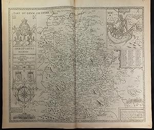
Theatre of the Empire of Great Britaine. Shropshyre described the Sittuation of Shrowesbury Shewed With the Armes of thos Earles, and other Memorable things obsered.
Published by London: Bassett & Chiswell, 1676
Single sheet (15 x 20 inches) Full margins showing the plate mark (slight browning to edge, crease upper left corner, watermark, top right page fray). An appealing uncolored map of Shropshire County; an excellent part of John Speed's Theatre of the Empire of Great Britaine. The plate was engraved in Amsterdam by the great Dutch mapmaker Jodocus Hondius, exhibiting the highest level of craftsmanship and artistic embellishment. The left-hand side of the map contains a large frame with an elaborate illustrative version of the Royal Arms. Highlighted below are the arms of Roger Montgomery, 1st Earl of Shrewsbury and William the Conqueror's principle counselor; as well as John Talbot, 1st Earl of Shrewsbury and decorated military commander during the Hundred Year's War. An elegant compass rose and scale of miles finish the frame. A particularly desirable part of this map belongs to the vignette of the Battle of Shrewsbury, fought between Henry IV and Sir Henry Percy (Harry Hotspur) in 1403. The Battle is described beneath the vignette as a framed text format. Shrowesbery (i.e. Shrewsbury) is laid out as an enclosed town plan. The town is represented with its shield. Known as a bustling market town on the Severne River, Shrewsbury is filled with squares, homes, a residential castle and abbey. An extensive key guide is included for the letters marking the significant roads and buildings within Shrewsbury. It is noteworthy to mention this town plan was mapped by Speed himself, as indicated by the 'Scale of Pases". The county maps found in the Theatre of the Empire of Great Britaine were the first consistent attempt to show territorial divisions, but it was mainly Speed's town plans that were the major innovation and probably his greatest contribution to British cartography. Together, they formed the first printed collection of town plans of the British Isles and, for at least 50 of the 73 included in the Theatre, it was the first time these towns had been mapped. While being the first English atlas of the British Isles, Speed's Atlas was also one of the first attempts to accurately survey Ireland and to incorporate a comprehensive list of their town plans into the maps. The 1676 edition of Speed's atlas never came with original color. The examples of this map of Shropshire should always be left uncolored and never colored. Born in Cheshire, John Speed developed his interest in maps in the 1580s, after moving to London to pursue his passions outside of tailoring. He there joined the Society of Antiquaries, where his enthusiasm for cartography won him the attention of William Camden, Robert Cotton, and Sir Fulke Greville. By working with these figures, Speed was able to do a large amount of research for his own work. In 1596, Greville bequeathed Speed with an unlimited allowance to research, and then later write, the Historie of Great Britaine. It was during this project which Speed had the encouragement to add a cartographic supplement to the work - what we today know as his most famous atlas. After being first published in 1611-1612, the 'Theatre of Great Britain' dominated the seventeenth-century English map market, going through many reprints and editions. Thanks to the Atlas' success, Speed earned the title of England's most well-known Stuart period cartographer and his work became the blueprint for folio atlases until the mid-18th century. Historically, Speed is also noted for placing England into the mainstream of map publishing, which had been dominated by the Dutch since the late sixteenth century. This map of Shropshire is an excellent part of the Theatre of the Empire of Great Britaine, and would be an outstanding addition to all map collections. For more information on this map, or a warm welcome to see other maps and books of our collection at 72nd Street NYC, please contact Natalie Zadrozna.
-
Theatre of the Empire of Great Britaine. Penbrokshyre described and the sittuations both of Penbroke and St Davids Shewed in due form as they were taken by John Speed.
Published by London: Bassett & Chiswell, 1676
Single sheet (15 x 20 inches) Full margins showing the plate mark (slight browning to edge) A handsome uncolored 1676 edition county map of Penbrokshyre [Pembrokeshire]; taken from John Speed's illustrious Theatre of the Empire of Great Britaine. Engraved by Dutch mapmaker Jodocus Hondius in 1610, the map is a prime example of the level of craftsmanship and detail which went into the making of this Atlas. The map boasts elaborate elements to delight our eyes. A decorative title cartouche with the royal arms introduces this mountainous county to the viewer. Percelye Hill, the highest point of the county, especially stands out thanks to its beautiful shadows engraved Hondius. Two town plan insets belong to this map: Penbroke and St. Davids. The fairly symmetrical plans exhibit a compass rose and appropriate shield. Pembroke is principally highlighted for its royal significance as the birthplace of Henry Tudor, the future King Henry VII. St Davids was final resting place of Wales' namesake patron saint; making it the de facto ecclesiastical capital of Wales. The exceptional point to these two cities is that they were mapped out by John Speed himself, as indicated by the signature 'Scale of Pases'. The edge of the map sets up a selection of eleven Earls and Dukes, which ruled over Pembokeshire over the centuries. The most notable shield belongs to Anne Boleyn, who received this title from her future spouse King Henry VIII. This was the first hereditary peerage title granted to a woman in England. The county maps found in the Theatre of the Empire of Great Britaine were the first consistent attempt to show territorial divisions, but it was mainly Speed's town plans that were the major innovation and probably his greatest contribution to British cartography. Together, they formed the first printed collection of town plans of the British Isles and, for at least 50 of the 73 included in the Theatre, it was the first time these towns had been mapped. While being the first English atlas of the British Isles, Speed's Atlas was also one of the first attempts to accurately survey Ireland and to incorporate a comprehensive list of their town plans into the maps. The 1676 edition of Speed's atlas never came with original color. The examples of this map of Penbrokshyre should always be uncolored and never colored. Born in Cheshire, John Speed developed his interest in maps in the 1580s, after moving to London to pursue his passions outside of tailoring. He there joined the Society of Antiquaries, where his enthusiasm for cartography won him the attention of William Camden, Robert Cotton, and Sir Fulke Greville. By working with these figures, Speed was able to do a large amount of research for his own work. In 1596, Greville bequeathed Speed with an unlimited allowance to research, and then later write, the Historie of Great Britaine. It was during this project which Speed had the encouragement to add a cartographic supplement to the work - what we today know as his most famous atlas. After being first published in 1611-1612, the 'Theatre of Great Britain' dominated the seventeenth-century English map market, going through many reprints and editions. Thanks to the Atlas' success, Speed earned the title of England's most well-known Stuart period cartographer and his work became the blueprint for folio atlases until the mid-18th century. Historically, Speed is also noted for placing England into the mainstream of map publishing, which had been dominated by the Dutch since the late sixteenth century. This map of Penbrokshyre is an excellent part of the Theatre of the Empire of Great Britaine, and would be an outstanding addition to all map collections. For more information on this map, or a warm welcome to see other maps and books of our collection at 72nd Street NYC, please contact Natalie Zadrozna.
-
Theatre of the Empire of Great Britaine. Norfolk A County Flourishing & Populous Describes and Devided With The Armes of Such Noble Families as have Borne the Titles Thero750f.
Published by London:Bassett & Chiswell, 1676
"Single sheet (15 x 20 inches) Full margins showing the plate mark (slight browning to edge, creased centerfold, repaired tear left page bottom). A highly attractive county map of Norfolk from John Speed's revered Theatre of the Empire of Great Britaine. Engraved by Jodocus Hondius in his workshop in Amsterdam, this map is a prime example of the level of craft and detail found in Speed's Atlas. The county of Norfolk touches its border with Cambridge, Suffolke, Mershland, and the Sea. Norfolk is presented to us as a rich county, filled with significant building, churches, and green nature. The inset town plan of Norwiche is handsomely portrayed as a bustling river town; full of building and boats and surrounded by green farmland. The Norwiche coat of arms decorate the plan. A highly attractive element of Speed's map is the vignette depicting the battle scene and commentaries of the two rebellions: the Peasant's Revolt in 1381 and Ket's Rebellion in 1547. The map is further embellished down the left side with coats of arms of the Earls and Dukes of Norfolk. Notable men include Thomas of Brotherton, son of King Edward II, claiming earldom in 1312; and Thomas de Mowbray, a rebellious nobleman, whose execution was described by Shakespeare. Speed drew on the map-work of Christopher Saxon for his map of Norfolk. "Described by Christopher Saxton Augmented by I. Speede [ ] " The county maps found in the Theatre of the Empire of Great Britaine were the first consistent attempt to show territorial divisions, but it was mainly Speed's town plans that were the major innovation and probably his greatest contribution to British cartography. Together, they formed the first printed collection of town plans of the British Isles and, for at least 50 of the 73 included in the Theatre, it was the first time these towns had been mapped. While being the first English atlas of the British Isles, Speed's Atlas was also one of the first attempts to accurately survey Ireland and to incorporate a comprehensive list of their town plans into the maps. The 1676 edition of Speed's atlas never came with original color. The examples of this map of Norfolk should always be uncolored and never colored. Born in Cheshire, John Speed developed his interest in maps in the 1580s, after moving to London to pursue his passions outside of tailoring. He there joined the Society of Antiquaries, where his enthusiasm for cartography won him the attention of William Camden, Robert Cotton, and Sir Fulke Greville. By working with these figures, Speed was able to do a large amount of research for his own work. In 1596, Greville bequeathed Speed with an unlimited allowance to research, and then later write, the Historie of Great Britaine. It was during this project which Speed had the encouragement to add a cartographic supplement to the work - what we today know as his most famous atlas. After being first published in 1611-1612, the 'Theatre of Great Britain' dominated the seventeenth-century English map market, going through many reprints and editions. Thanks to the Atlas' success, Speed earned the title of England's most well-known Stuart period cartographer and his work became the blueprint for folio atlases until the mid-18th century. Historically, Speed is also noted for placing England into the mainstream of map publishing, which had been dominated by the Dutch since the late sixteenth century. This map of Norfolk is an excellent part of the Theatre of the Empire of Great Britaine, and would be an outstanding addition to all map collections. For more information on this map, or a warm welcome to see other maps and books of our collection at 72nd Street NYC, please contact Natalie Zadrozna.".
-
Theatre of the Empire of Great Britaine. Montgomery Shire.
Published by London: Bassett & Chiswell, 1676
Single sheet (15 x 20 inches) Full margins showing the plate mark (slight browning to edge, foxing). A handsome uncolored map of Montogmeryshire, as part of John Speed's famous Theatre of the Empire of Great Britaine. The copper plates for this map were gngraved by Jodocus Hondius in his workshop in Amsterdam, resulting in a prime example of the level of craft and detail found in the Atlas. A title cartouche baring the royal coat of arms flanked by a set of hounds, introduce us to this stunning map of Montgomery Shire. A desirable and innovative aspect to Speed's maps are his town plan insets. Here we find the town of Montgomery laid out by John Speed himself, as indicated by the 'Scale of Pases'. This town plan was particularly mapped to the smallest details, such as the water well and towers. The key for his letter guide to the significant roads and buildings and Montgomery shield are also included. The coat of arms of Phillip Herbert, the 1st Earle of Montgomery, is showcased in the lower left corner. Philip was first given the title of 4th Earl of Pembroke and was the chief favorite of James I for many years. In 1605, King James I of England created him Earl of Montgomery and Baron Herbert of Shurland. In 1630, when he succeeded to the Earldom of Pembroke, the head of the Herbert family has carried the double title of Earl of Pembroke and Montgomery. The arms shown here are used for the representations of both titles. This edition of the map has the later addition of a strapwork frame, holding the text "Described by Christopher Saxton Augemented and published by John Speed and are to be solde by the Thomas Bassett in Fleetstreet, and Ric Chiswell in St Paul's Churchyard". Some earlier published maps left this space blank. The county maps found in the Theatre of the Empire of Great Britaine were the first consistent attempt to show territorial divisions, but it was mainly Speed's town plans that were the major innovation and probably his greatest contribution to British cartography. Together, they formed the first printed collection of town plans of the British Isles and, for at least 50 of the 73 included in the Theatre, it was the first time these towns had been mapped. While being the first English atlas of the British Isles, Speed's Atlas was also one of the first attempts to accurately survey Ireland and to incorporate a comprehensive list of their town plans into the maps. The 1676 edition of Speed's atlas never came with original color. The examples of this map of the Montgomeryshire should always be uncolored and never colored. Born in Cheshire, John Speed developed his interest in maps in the 1580s, after moving to London to pursue his passions outside of tailoring. He there joined the Society of Antiquaries, where his enthusiasm for cartography won him the attention of William Camden, Robert Cotton, and Sir Fulke Greville. By working with these figures, Speed was able to do a large amount of research for his own work. In 1596, Greville bequeathed Speed with an unlimited allowance to research, and then later write, the Historie of Great Britaine. It was during this project which Speed had the encouragement to add a cartographic supplement to the work - what we today know as his most famous atlas. After being first published in 1611-1612, the 'Theatre of Great Britain' dominated the seventeenth-century English map market, going through many reprints and editions. Thanks to the Atlas' success, Speed earned the title of England's most well-known Stuart period cartographer and his work became the blueprint for folio atlases until the mid-18th century. Historically, Speed is also noted for placing England into the mainstream of map publishing, which had been dominated by the Dutch since the late sixteenth century. This map of Montgomeryshire is an excellent part of the Theatre of the Empire of Great Britaine, and would be an outstanding addition to all map collections. For more information on this map, or a warm welcome.
-
Theatre of the Empire of Great Britaine. "Anglesey Antiently called Mona. Described 1610"
Published by London: Bassett & Chiswell, 1676
Single sheet (15 x 20 inches) Full margins showing the plate mark (slight browning to edge, light foxing, offsetting, creased corner, light ink rubbing) An extraordinary uncolored 1676 edition of Anglesey; part of the renowned Theatre of the Empire of Britaine by English cartographer John Speed. This edition was published by Thomas Bassett and Richard Chiswell in London. The copper plates used for the printing of John Speed's maps were engraved by Dutch mapmaker, Jodocus Hondius, in 1610. Hondius is most well-known for his elaborate, early maps of Europe and the New World. These maps created are of the most highly sought after county maps; as they are famous for their accuracy, level of detail, and craftsmanship. This map of Anglesey is one of the best county maps available. An island off of the coat of Wales, Anglesey is considered the largest island of Wales. This is expertly portrayed by Hondius' engraving, sitting in the center surrounded by the Irish Sea and its calm waves. This map is further embellished with a gorgeous compass rose and extended rhumb lines; two full mast sailing ships, and elegant strapwork cartouches. A plan of Beaumaris is provided in the top right corner, with a legend giving the location of its most significant landmarks. Speed does a wonderful job highlighting the Beaumaris Castle, built in 1282 by King Edward I as part of his campaign to conquer the north of Wales. This town was mapped by John Speed himself, as it bares the 'Scale of Pases' as indication. The plan is decorated with the shield of Anglesey; a simple compass rose; and what appears to be a merman preparing to attack a whale in the adjacent sea. Along with a cartouche holding the outstanding coat of arms of the King; there are several other arms depicted. Christopher Villiers, 1st Earl of Angelesey (1623), Master of Robes to King James I; and Arthur Annesley, 1st Earl of Anglesey (1661), an Anglo-Irish royalist statesman. The county maps found in the Theatre of the Empire of Great Britaine were the first consistent attempt to show territorial divisions, but it was mainly Speed's town plans that were the major innovation and probably his greatest contribution to British cartography. Together, they formed the first printed collection of town plans of the British Isles and, for at least 50 of the 73 included in the Theatre, it was the first time these towns had been mapped. While being the first English atlas of the British Isles, Speed's Atlas was also one of the first attempts to accurately survey Ireland and to incorporate a comprehensive list of their town plans into the maps. The 1676 edition of Speed's atlas never came with original color. The examples of this map of Anglesey should always be uncolored and never colored. Born in Cheshire, John Speed developed his interest in maps in the 1580s, after moving to London to pursue his passions outside of tailoring. He there joined the Society of Antiquaries, where his enthusiasm for cartography won him the attention of William Camden, Robert Cotton, and Sir Fulke Greville. By working with these figures, Speed was able to do a large amount of research for his own work. In 1596, Greville bequeathed Speed with an unlimited allowance to research, and then later write, the Historie of Great Britaine. It was during this project which Speed had the encouragement to add a cartographic supplement to the work - what we today know as his most famous atlas. After being first published in 1611-1612, the 'Theatre of Great Britain' dominated the seventeenth-century English map market, going through many reprints and editions. Thanks to the Atlas' success, Speed earned the title of England's most well-known Stuart period cartographer and his work became the blueprint for folio atlases until the mid-18th century. Historically, Speed is also noted for placing England into the mainstream of map publishing, which had been dominated by the Dutch since the late sixteenth century. This map of Anglesey is an ex.