Order Total (1 Item Items):
Shipping Destination:

Weller Edward (718 results)
Skip to main search results
Product Type
- All Product Types
- Books (220)
- Magazines & Periodicals
- Comics
- Sheet Music
- Art, Prints & Posters (3)
- Photographs
- Maps (494)
-
Manuscripts &
Paper Collectibles (1)
Condition
Binding
Collectible Attributes
- First Edition (35)
- Signed (7)
- Dust Jacket (6)
- Seller-Supplied Images (550)
- Not Printed On Demand (699)
Free Shipping
Seller Location
Seller Rating
-

The Quite Remarkable Adventures of the Owl and the Pussycat
Published by NewStar Media, Incorporated, 1996
ISBN 10: 0787110426ISBN 13: 9780787110420
Book
Condition: Very Good. Weller, Wesla (illustrator). Used book that is in excellent condition. May show signs of wear or have minor defects.
More buying choices from other sellers on AbeBooks
New offers from � 17.64
Used offers from � 6.46
Also find Hardcover First Edition
-
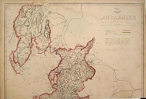
Single sheet. Original outline colour. A large map for the Weekly Dispatch Atlas. This has been trimmed at the bottom inside the engraved area but reaches as far South as Fleetwood. At this time the county included what is now part of Cumbria from Ambleside to Barrow and Walney Island and Cartmell. Central East West crease. Priced to recognise its truncation and condition. 46 x 31 cm.
-
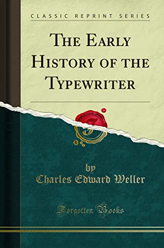
![Stock image for The early history of the typewriter [HARDCOVER] for sale by Books Puddle](https://pictures.abebooks.com/isbn/9789332866867-uk-300.jpg)
The early history of the typewriter [HARDCOVER]
Published by Isha Books, 2013
ISBN 10: 9332866864ISBN 13: 9789332866867
Book
Condition: New. pp. 91.
More buying choices from other sellers on AbeBooks
New offers from � 8.80
-
Single sheet. An original antique coloured map. Centrefold as issued. 30 x 22 cm.
-
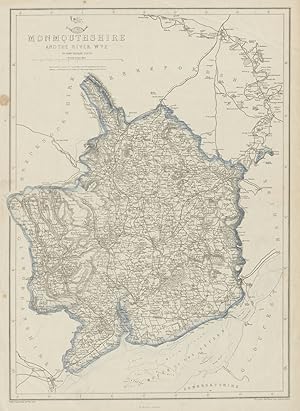
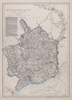
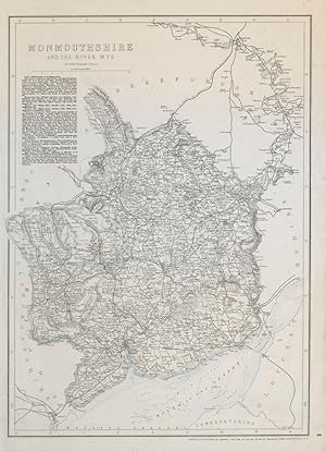
Condition: Fair. RIVER WYE VALLEY & MONMOUTHSHIRE. Antique county map. Railways. WELLER 1862. Antique map with original outline colour; Engraved by Edwd. Weller (1862). 43.5 x 31.5cm, 17.25 x 12.5 inches. Condition: Fair: Spot. There is nothing printed on the reverse side, which is plain.
-
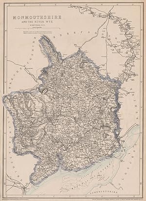
Condition: Good. RIVER WYE VALLEY & MONMOUTHSHIRE. Antique county map. Railways. WELLER 1863. Antique map with original outline colour; Engraved by Edwd. Weller (1863). 43.5 x 31.5cm, 17.25 x 12.5 inches. Condition: Good. The image shown may have been taken from a different example of this map than that which is offered for sale. The map you will receive is in good condition but there may be minor variations in the condition from that shown in the image. This map was coloured by hand at the time of publication, thus the colouration may vary slightly between different examples of the map; the colouring applied to the map you receive may differ slightly from that shown in the image. There is nothing printed on the reverse side, which is plain.
-
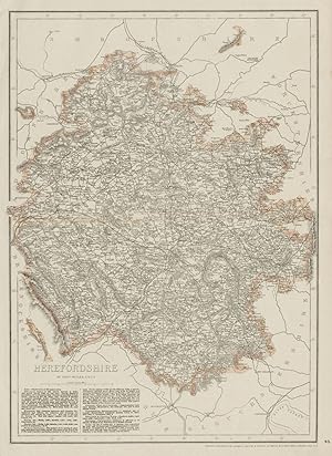
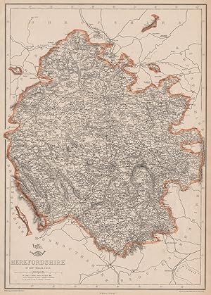
Condition: Good. HEREFORDSHIRE antique county map. Showing railways & exclaves. WELLER 1863. Antique map with original outline colour; Engraved by Edwd. Weller (1863). 44.0 x 31.5cm, 17.5 x 12.5 inches. Condition: Good. The image shown may have been taken from a different example of this map than that which is offered for sale. The map you will receive is in good condition but there may be minor variations in the condition from that shown in the image. This map was coloured by hand at the time of publication, thus the colouration may vary slightly between different examples of the map; the colouring applied to the map you receive may differ slightly from that shown in the image. There is nothing printed on the reverse side, which is plain.
-
Condition: Good. RIVER WYE VALLEY & MONMOUTHSHIRE. Antique county map. Railways. WELLER 1868. Antique map with original outline colour; Engraved by Edwd. Weller (1868). 43.5 x 31.5cm, 17.25 x 12.5 inches. Condition: Good. The image shown may have been taken from a different example of this map than that which is offered for sale. The map you will receive is in good condition but there may be minor variations in the condition from that shown in the image. This map was coloured by hand at the time of publication, thus the colouration may vary slightly between different examples of the map; the colouring applied to the map you receive may differ slightly from that shown in the image. There is nothing printed on the reverse side, which is plain.
-
Condition: Good. HEREFORDSHIRE. Antique county map. Showing exclaves & railways. WELLER 1863. Antique map with original outline colour; Engraved by Edwd. Weller (1863). 44.0 x 31.5cm, 17.5 x 12.5 inches. Condition: Good. The image shown may have been taken from a different example of this map than that which is offered for sale. The map you will receive is in good condition but there may be minor variations in the condition from that shown in the image. This map was coloured by hand at the time of publication, thus the colouration may vary slightly between different examples of the map; the colouring applied to the map you receive may differ slightly from that shown in the image. There is nothing printed on the reverse side, which is plain.
-
Condition: Good. RIVER WYE VALLEY & MONMOUTHSHIRE. Antique county map. Railways. WELLER c1865. Antique map with original outline colour; Engraved by Edwd. Weller (c1865). 45.5 x 33.0cm, 18 x 13 inches. Condition: Good. There is nothing printed on the reverse side, which is plain.
-
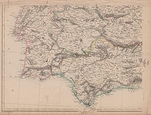
Condition: Good. SW IBERIA Spain Portugal railways Cadiz-Cordoba Lisbon-Santarem.WELLER 1862 map. Antique map with original outline colour; Engraved by Edwd. Weller (1862). 33.0 x 43.5cm, 13 x 17 inches. Condition: Good. Minor blemishes. There is nothing printed on the reverse side, which is plain. The map was produced a few years after the first railway in Portugal was completed in 1856, linking Lisbon to Carregado. The map shows this railway having been extended as far as Santarem, with further lines south of the Tagus to Setubal and Vendas. The map also shows the railway between Cadiz and Cordoba via Seville.
-
Condition: Good. SW IBERIA Spain Portugal railways Cadiz-Cordoba Lisbon-Santarem.WELLER 1863 map. Antique map with original outline colour; Engraved by Edwd. Weller (1863). 33.0 x 43.5cm, 13 x 17 inches. Condition: Good. The image shown may have been taken from a different example of this map than that which is offered for sale. The map you will receive is in good condition but there may be minor variations in the condition from that shown in the image. This map was coloured by hand at the time of publication, thus the colouration may vary slightly between different examples of the map; the colouring applied to the map you receive may differ slightly from that shown in the image. There is nothing printed on the reverse side, which is plain. The map was produced a few years after the first railway in Portugal was completed in 1856, linking Lisbon to Carregado. The map shows this railway having been extended as far as Santarem, with further lines south of the Tagus to Setubal and Vendas. The map also shows the railway between Cadiz and Cordoba via Seville.
-
The Early History of the Typewriter Classic Reprint
Published by Forgotten Books, 2018
ISBN 10: 0282362789ISBN 13: 9780282362782
Book
PAP. Condition: New. New Book. Shipped from UK. Established seller since 2000.
More buying choices from other sellers on AbeBooks
New offers from � 16.35
-
Contributions to the Stratigraphy of Illinois (Classic Reprint)
Published by Forgotten Books, 2018
ISBN 10: 1528117611ISBN 13: 9781528117616
Book Print on Demand
Paperback. Condition: New. Print on Demand. Excerpt from Contributions to the Stratigraphy of Illinois. About the Publisher, Forgotten Books publishes hundreds of thousands of rare and classic books. This book is a reproduction of an important historical work. Forgotten Books uses state-of-the-art technology to digitally reconstruct the work, preserving the original format whilst repairing imperfections present in the aged copy. In rare cases, an imperfection in the original, such as a blemish or missing page, may be replicated in our edition. We do, however, repair the vast majority of imperfections successfully; any imperfections that remain are intentionally left to preserve the state of such historical works. This text has been digitally restored from a historical edition. Some errors may persist, however we consider it worth publishing due to the work's historical value. The digital edition of all books may be viewed on our website before purchase. print-on-demand item.
-

The Early History of the Typewriter
Published by LEGARE STREET PR, 2022
ISBN 10: 1015556116ISBN 13: 9781015556119
Book Print on Demand
PAP. Condition: New. New Book. Shipped from UK. THIS BOOK IS PRINTED ON DEMAND. Established seller since 2000.
More buying choices from other sellers on AbeBooks
New offers from � 17.21
-

Map, Paper. Condition: VG+. Edward Weller (illustrator). lATER. Hand coloured, engraved map of South America. From an atlas published by Longmans and drawn by Edward Weller [d1884]. Undated, circa 1865-70. Size - 19.5 by 25.5 cm on a sheet 23 by 29.5 cm. Original fold at centre - shows no weakness. Clean and unmarked, no foxing. Scan available. Ships via inexpensive Canada Post Lettermail within North America, in card sleeve. From $3.00 to $6.50 depending on exact weight and location. Image available. Enquire for rates to Worldwide destinations.
-
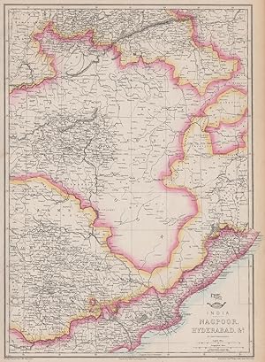
Condition: Good. BRITISH INDIA. 'Nagpoor, Hyderabad, &c.'. WELLER. Dispatch atlas 1863 old map. Antique map with original outline colour; Engraved by Edwd. Weller (1863). 44.0 x 32.0cm, 17.25 x 12.75 inches. Condition: Good. The image shown may have been taken from a different example of this map than that which is offered for sale. The map you will receive is in good condition but there may be minor variations in the condition from that shown in the image. This map was coloured by hand at the time of publication, thus the colouration may vary slightly between different examples of the map; the colouring applied to the map you receive may differ slightly from that shown in the image. There is nothing printed on the reverse side, which is plain.
-
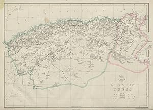
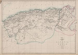
Condition: Fair. NORTH AFRICA. 'Algeria and Tunis'. Tunisia. WELLER 1862 old antique map chart. Antique map with original outline colour; Engraved by Edwd. Weller (1862). 32.0 x 45.5cm, 12.75 x 17.75 inches. Condition: Fair: Blemishes; Dispatch Atlas stamp in top left corner margin. There is nothing printed on the reverse side, which is plain.
-
Condition: Good. NORTH AFRICA. 'Algeria and Tunis'. Tunisia. WELLER 1863 old antique map chart. Antique map with original outline colour; Engraved by Edwd. Weller (1863). 32.0 x 45.5cm, 12.75 x 17.75 inches. Condition: Good. The image shown may have been taken from a different example of this map than that which is offered for sale. The map you will receive is in good condition but there may be minor variations in the condition from that shown in the image. This map was coloured by hand at the time of publication, thus the colouration may vary slightly between different examples of the map; the colouring applied to the map you receive may differ slightly from that shown in the image. There is nothing printed on the reverse side, which is plain.
-
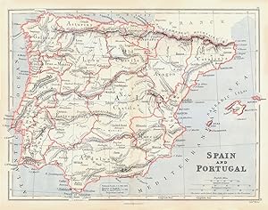
Condition: Good. IBERIA. Spain and Portugal showing provinces. BUTLER 1888 old antique map. Antique colour map; Scale 1:3.861.000; Edwd. Weller (1888). 33.0 x 26.0cm, 13 x 10.25 inches; this is a folding map. Condition: Good. The image shown may have been taken from a different example of this map than that which is offered for sale. The map you will receive is in good condition but there may be minor variations in the condition from that shown in the image. There is nothing printed on the reverse side, which is plain.
-
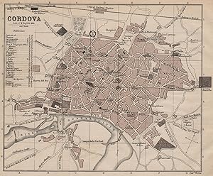
Condition: Good. CORDOBA CORDOVA antique town city plan ciudad. Spain Espana. MURRAY 1898 map. Antique colour travel map; Edwd. Weller (1898). 15.0 x 18.5cm, 6 x 7.25 inches; this is a folding map. Condition: Good. The image shown may have been taken from a different example of this map than that which is offered for sale. The map you will receive is in good condition but there may be minor variations in the condition from that shown in the image. There is nothing printed on the reverse side, which is plain.
-
The Isle Of Man ( Bacon's New Scale Ordnance Atlas of the British Isles )
Published by George W Bacon, 1881
First Edition
Condition: Very Good. 1st edition. Single sheet, VG. Sheet size 21 x 13.5 inches ( 53 x 34 cm ) original hand colouring, 1.75 miles to 1 inch, a fine copy. Single sheet from the 1881 edition of Bacon's New Scale Ordnance Atlas of the British Isles, showing the railways etc of the Island. 50 grams.
-
Condition: Good. SCOTLAND. Showing counties; Inset central belt, Shetland Isles. BUTLER 1888 map. Antique colour map; Scale 1:1.680.500; Edwd. Weller (1888). 24.0 x 33.0cm, 9.5 x 13 inches; this is a folding map. Condition: Good. The image shown may have been taken from a different example of this map than that which is offered for sale. The map you will receive is in good condition but there may be minor variations in the condition from that shown in the image. There is nothing printed on the reverse side, which is plain.
-

Ferroelectricity
Published by Elsevier Pub. Co., 1967
ISBN 10: 0444406298ISBN 13: 9780444406293
Book
Condition: Good. 331 pp., hardcover, ex library else text clean & binding tight (lacks dust jacket). - If you are reading this, this item is actually (physically) in our stock and ready for shipment once ordered. We are not bookjackers. Buyer is responsible for any additional duties, taxes, or fees required by recipient's country.
-
Map, Paper. Condition: VG+. Edward Weller (illustrator). lATER. Hand coloured, engraved map of Holland and Belgium. From an atlas published by Longmans and drawn by Edward Weller [d1884]. Undated, circa 1865-70. Size - 19.5 by 25.5 cm on a sheet 23 by 29.5 cm. Original fold at centre - shows no weakness. Clean and unmarked, no foxing. Scan available.
-
Map on Cloth. Condition: VG. Edward Weller (illustrator). lATER. Hand coloured, engraved map of England and Wales, counties shown. From an atlas published by Longmans and drawn by Edward Weller [d1884]. Undated, circa 1865-70. Size - 19.5 by 25.5 cm on a sheet 23 by 29.5 cm. Original fold at centre - shows no weakness. Clean and unmarked, no foxing. Scan available.
-
Map, Paper. Condition: VG+. Edward Weller (illustrator). lATER. Hand coloured, engraved map of Scotland, counties shown. Inset shows the Shetland Islands. From an atlas published by Longmans and drawn by Edward Weller [d1884]. Undated, circa 1865-70. Size - 19.5 by 25.5 cm on a sheet 23 by 29.5 cm. Original fold at centre - shows no weakness. Clean and unmarked, no foxing. Scan available.
-
Map, Paper. Condition: VG+. Edward Weller (illustrator). lATER. Hand coloured, engraved map of France, departments shown. Inset shows Corsica. From an atlas published by Longmans and drawn by Edward Weller [d1884]. Undated, circa 1865-70. Size - 19.5 by 25.5 cm on a sheet 23 by 29.5 cm. Original fold at centre - shows no weakness. Clean and unmarked, no foxing. Scan available.
-
Map, Paper. Condition: VG+. Edward Weller (illustrator). lATER. Hand coloured, engraved map of New Zealand. Inset shows Western Australia. From an atlas published by Longmans and drawn by Edward Weller [d1884]. Undated, circa 1865-70. Size - 19.5 by 25.5 cm on a sheet 23 by 29.5 cm. Original fold at centre - shows no weakness. Clean and unmarked, no foxing. Scan available.
-
Map, Paper. Condition: VG+. Edward Weller (illustrator). lATER. Hand coloured, engraved map of the West Indies and Central America. From an atlas published by Longmans and drawn by Edward Weller [d1884]. Undated, circa 1865-70. Size - 19.5 by 25.5 cm on a sheet 23 by 29.5 cm. Original fold at centre - shows no weakness. Clean and unmarked, no foxing. Scan available.