Order Total (1 Item Items):
Shipping Destination:

Sanson D'abbeville, Nicolas 1600 1667 , Guillaume D 1703 , and Adrien D 1708 (2 results)
You searched for:
Author:
SANSON D'ABBEVILLE, NICOLAS 1600 1667 , GUILLAUME D 1703 , AND ADRIEN D 1708
Edit your search
Skip to main search results
Product Type
- All Product Types
- Books (1)
- Magazines & Periodicals
- Comics
- Sheet Music
- Art, Prints & Posters
- Photographs
- Maps (1)
-
Manuscripts &
Paper Collectibles
Condition
- All Conditions
- New
- Used
Binding
- All Bindings
- Hardcover (1)
- Softcover
Collectible Attributes
- First Edition (1)
- Signed
- Dust Jacket
- Seller-Supplied Images
- Not Printed On Demand
Seller Location
Seller Rating
-

No Binding. Condition: Very Good. Copperplate map (Image: 15 1/2 x 21 1/2 in.; 39.4 x 54.6 cm), engraved by Jean Somer, partially handcolored in outline, decorative cartouche in lower right corner. BINDING/CONDITION: Matted and framed, not examined out of frame. A VERY BRIGHT AND CRISP IMPRESSION OF THE FIRST LARGE-SCALE MAP TO PRESENT ALL FIVE GREAT LAKES IN A COMPARATIVELY ACCURATE CORRELATION. "This delineation would considerably influence the cartography of the region for over 100 years; it was not to be superseded until Guillaume de L'Isle's Carte du Canada, in 1703" (Burden). Sanson's transformative map shows the entire Great Lakes region and the St. Lawrence River basin in detail. It names "L. Erie, ou du Chat" as a recognizable and distinct lake for the first time; the name derives from the native name "Derie" which referred to the "panther-like qualities of the feared local native Indians" (Burden). The northern waters remain the same with the exception of Hudson Bay, which is depicted in more detail. Sanson drew on source information from the Jesuit missionaries who ventured westward after Champlain's death and published annual accounts, or "Relations," of their findings between 1632 and 1673. This included Jean Nicollet's discovery of Lake Michigan, "Lac des Puans," in 1634 and Father Paul Ragueneau's "Relation" of 1648 which describes his visit to Niagara Falls, three decades before Father Louis Hennepin's formal description of the cataracts. Sanson also made several improvements in his east coast delineation: Long Island is introduced with New Amsterdam in its correct position. The Delaware River is more accurately shown, with "N[ouvelle] Su�de (the former Swedish colony of Fort Christina) at its mouth, the site of present-day Willmington. The borders of Virginia are defined but none of the English settlements are given. PROVENANCE: Anne H. & Frederick Vogel III (sale, Sotheby's New York, 19 January 2019, lot 1138); Martayan Lan Augustyn, New York, 2012 REFERENCES: Burden, The Mapping of North America, 318; Karpinski, Great Lakes Region,
-
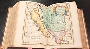
Description de tout l'Univers, en plusieurs Cartes, & en divers Traitez de Geographie et d'Histoire.
Published by Amsterdam: Fran�ois Halma, 1700., 1700
First Edition
8vo., (9 x 7 � inches). Hand-colored vignette title page printed in two colors, sectional title pages, hand-colored woodblock historiated initial letters, "Message to the Bookbinder" in Dutch and French at end (this copy without the double-page allegorical title page; upper half of pp. 1/2 of Bion cut away). 71 (of 74) double-page maps with hand color in full, heightened with liquid gold, 10 (of 15) plates, 8 of these folding (some pale stains). Contemporary mottled calf, the spine in six compartment separated by five raised bands, gilt lettered in one and decorated in the rest (hinges starting, gilt lettering faded, extremities worn). Provenance: Probably from the library of Andrew Dury (fl. mid-18th century), mapmaker and publisher, his widow's sale 1787. With extensive contemporary manuscript annotations throughout by Charles Skottowe, Hinsale, including the note "This book was bought at Mrs. Dury's Auction, for 101 by Chas. Skottowe Nov 8 1787" on verso of title page. With manuscript ownership inscription of "J. F. Mournan, 1st May 1887, Springmount Hallow" to sectional title page of Africa section. Freeman's, 1/21/2005, Lot 203. First edition. Pocket atlas published by Fran�ois Halma, the maps reduced from Sanson's 1658 folio atlas, with Luyt's Tables Geographiques & Bion's l'Usage des Globes, featuring striking folding plates diagramming the workings of the celestial systems. Without the world map, the map of southern Germany, and the map of Madagascar. Born in Abbeville, a town in the Picardy region of France, in 1600, Sanson was the most noted French cartographer in modern history. Mapmaker to Louis XIV, King of France, Sanson endowed his maps with the most recent geographical information as well as the finest and sharpest engraving of the period. His "Cartes Generales de Toutes les Parties du Monde" was the most important single product of French commercial cartography of the seventeenth century. Sanson sparked a renaissance in geographical endeavor in his native country, which had not been a major player on the international cartographic stage since the great Oronce Fin� in the sixteenth century. With this atlas, Sanson laid the foundations of French domination in map production, initiating the so-called "French school of cartography," a school that was unprecedented in its attention to precision and scientific detail and discarded much of the decorative embellishments of previous maps as irrelevant. From Sanson's time in the second half of the seventeenth century until the latter part of the eighteenth century, French geographical conceptions were more influential than those put forward by any other nation. With this landmark atlas, Sanson all but single-handedly caused the center of cartographic innovation to shift from Holland to France. Although this atlas is always listed under Nicolas Sanson, it is essentially Francois Halma's plagiarized pocket version of the Sanson atlas, reduced from Sanson's 1658 folio atlas, with the map divided into Continent groups. "Fran�ois Halma was an editor, printer and publisher of theological, historical and geographical works. His output was large. He first established his business in Utrecht in 1674, then moved to Amsterdam and finally settled in Leeuwarden where he died in 1722. Among his works was an edition of Mercator's Ptolemy (1695) and a reduced-size edition of Sanson's large atlas under the new title 'Description De Tout L'Univers' [as here]" (Shirley, Printed Maps of the British Isles 1650-1750, p. 66). Koeman II, Hal1; Phillips, Atlases 528; Shirley Pastoureau, Sanson VII G.