
Order Total (1 Item Items):
Shipping Destination:

Neele, Samuel (52 results)
Skip to main search results
Product Type
- All Product Types
- Books (28)
- Magazines & Periodicals
- Comics
- Sheet Music
- Art, Prints & Posters (2)
- Photographs
- Maps (21)
-
Manuscripts &
Paper Collectibles (1)
Condition
Binding
Collectible Attributes
Free Shipping
Seller Location
Seller Rating
-

No Binding. Condition: Very Good. Samuel Neele, Engraver (illustrator). Antique Copper Engraved Map of Austria, circa 1810. Black and white, as published, no colour. At foot of map is stated - 'Pubd. as the Act directs 31 March 1810 by J. Wilkes'. Size of map within heavy black borders is 23.5 cm by 19 cm. Clean white, thick paper, a very little, light foxing along some edges. Adequate margins for matting. We ship worldwide by mail at cost. Size: 27cm by 20cm. Map.
-
No Binding. Condition: Very Good. Samuel Neele, Engraver (illustrator). Antique Copper Engraved Map of County Durham, England dated 1803. Black and white, as published, no colour. At foot of map is stated - 'London Published as the Act directs, April 16, 1803 by J. Wilkes'. Engraved by Samuel Neele. Size of map within heavy black borders is 23.3 cm by 18.8 cm. Clean white, thick paper. Some faint foxing to margins only. Adequate margins for matting. We ship worldwide by mail at cost. Size: 27cm by 20cm. Map.
-
![Seller image for A general collection of the ancient Irish music : containing a variety of admired airs never before published, and also the compositions of Conolan and Carolan [LeatherBound] for sale by True World of Books](https://pictures.abebooks.com/inventory/md/md31534344451.jpg)
LeatherBound. Condition: New. LeatherBound edition. Condition: New. Reprinted from 1796 edition. Leather Binding on Spine and Corners with Golden leaf printing on spine. Bound in genuine leather with Satin ribbon page markers and Spine with raised gilt bands. A perfect gift for your loved ones. NO changes have been made to the original text. This is NOT a retyped or an ocr'd reprint. Illustrations, Index, if any, are included in black and white. Each page is checked manually before printing. As this print on demand book is reprinted from a very old book, there could be some missing or flawed pages, but we always try to make the book as complete as possible. Fold-outs, if any, are not part of the book. If the original book was published in multiple volumes then this reprint is of only one volume, not the whole set. Sewing binding for longer life, where the book block is actually sewn (smythe sewn/section sewn) with thread before binding which results in a more durable type of binding. Pages: 55 Language: English.
-
No Binding. Condition: Very Good. Samuel Neele, Engraver (illustrator). Antique Copper Engraved Map of Russia in Europe dated 1826. Gulf of Finland to the Ural Mountains - Lapland south to the Crimea. Black and white, as published, no colour. At foot of map is stated - 'Engraved for the 'Encyclopaedia Londinensis' [Wilkes], 1826'. Size of map within heavy black borders is 18.7 cm by 23.5 cm. Clean white, thick paper. No foxing. Adequate margins for matting. We ship worldwide by mail at cost. Size: 27cm by 20cm. Map.
-
![Seller image for A dictionary of arts and sciences Volume 3 [LeatherBound] for sale by True World of Books](https://pictures.abebooks.com/inventory/md/md31534100553.jpg)
A dictionary of arts and sciences Volume 3 [LeatherBound]
Publication Date: 2023
Book Print on Demand
LeatherBound. Condition: New. LeatherBound edition. Condition: New. Reprinted from 1806 edition. Leather Binding on Spine and Corners with Golden leaf printing on spine. Bound in genuine leather with Satin ribbon page markers and Spine with raised gilt bands. A perfect gift for your loved ones. NO changes have been made to the original text. This is NOT a retyped or an ocr'd reprint. Illustrations, Index, if any, are included in black and white. Each page is checked manually before printing. As this print on demand book is reprinted from a very old book, there could be some missing or flawed pages, but we always try to make the book as complete as possible. Fold-outs, if any, are not part of the book. If the original book was published in multiple volumes then this reprint is of only one volume, not the whole set. Sewing binding for longer life, where the book block is actually sewn (smythe sewn/section sewn) with thread before binding which results in a more durable type of binding. Pages: 292 Volume 3 Language: English.
-
No Binding. Condition: Very Good. Samuel Neele, Engraver (illustrator). Antique Copper Engraved Map of Asia dated 1796. Includes Australia then known as New Holland, and the entire Indian Ocean. Black and white, as published, no colour. At foot of map is stated - 'London Pubd. as the Act directs August 13, 1796 by J. Wilk[e]s'. Size of map within heavy black borders is 18.3 cm by 23 cm. Clean white, thick paper, a very little, light foxing along some edges - none on map. Adequate margins for matting. We ship worldwide by mail at cost. Size: 27cm by 20cm. Map.
-
![Seller image for The British Tourists: Through England, Wales, Scotland, and Ireland . [LeatherBound] for sale by True World of Books](https://pictures.abebooks.com/inventory/md/md31533869687.jpg)
The British Tourists: Through England, Wales, Scotland, and Ireland . [LeatherBound]
Publication Date: 2023
Book Print on Demand
LeatherBound. Condition: New. LeatherBound edition. Condition: New. Reprinted from 1798 edition. Leather Binding on Spine and Corners with Golden leaf printing on spine. Bound in genuine leather with Satin ribbon page markers and Spine with raised gilt bands. A perfect gift for your loved ones. NO changes have been made to the original text. This is NOT a retyped or an ocr'd reprint. Illustrations, Index, if any, are included in black and white. Each page is checked manually before printing. As this print on demand book is reprinted from a very old book, there could be some missing or flawed pages, but we always try to make the book as complete as possible. Fold-outs, if any, are not part of the book. If the original book was published in multiple volumes then this reprint is of only one volume, not the whole set. Sewing binding for longer life, where the book block is actually sewn (smythe sewn/section sewn) with thread before binding which results in a more durable type of binding. Pages: 345 Language: English.
-
![Seller image for Travels through Germany, Switzerland, Italy, and Sicily : translated from the German of Frederic Leopold Count Stolberg Volume 1 [LeatherBound] for sale by True World of Books](https://pictures.abebooks.com/inventory/md/md31534000190.jpg)
LeatherBound. Condition: New. LeatherBound edition. Condition: New. Reprinted from 1796 edition. Leather Binding on Spine and Corners with Golden leaf printing on spine. Bound in genuine leather with Satin ribbon page markers and Spine with raised gilt bands. A perfect gift for your loved ones. NO changes have been made to the original text. This is NOT a retyped or an ocr'd reprint. Illustrations, Index, if any, are included in black and white. Each page is checked manually before printing. As this print on demand book is reprinted from a very old book, there could be some missing or flawed pages, but we always try to make the book as complete as possible. Fold-outs, if any, are not part of the book. If the original book was published in multiple volumes then this reprint is of only one volume, not the whole set. Sewing binding for longer life, where the book block is actually sewn (smythe sewn/section sewn) with thread before binding which results in a more durable type of binding. Pages: 572 Volume 1 Language: English.
-
![Seller image for Travels through Germany, Switzerland, Italy, and Sicily : translated from the German of Frederic Leopold Count Stolberg Volume 2 [LeatherBound] for sale by True World of Books](https://pictures.abebooks.com/inventory/md/md31533995653.jpg)
LeatherBound. Condition: New. LeatherBound edition. Condition: New. Reprinted from 1796 edition. Leather Binding on Spine and Corners with Golden leaf printing on spine. Bound in genuine leather with Satin ribbon page markers and Spine with raised gilt bands. A perfect gift for your loved ones. NO changes have been made to the original text. This is NOT a retyped or an ocr'd reprint. Illustrations, Index, if any, are included in black and white. Each page is checked manually before printing. As this print on demand book is reprinted from a very old book, there could be some missing or flawed pages, but we always try to make the book as complete as possible. Fold-outs, if any, are not part of the book. If the original book was published in multiple volumes then this reprint is of only one volume, not the whole set. Sewing binding for longer life, where the book block is actually sewn (smythe sewn/section sewn) with thread before binding which results in a more durable type of binding. Pages: 708 Volume 2 Language: English.
-
![Seller image for A dictionary of arts and sciences Volume 1 [LeatherBound] for sale by True World of Books](https://pictures.abebooks.com/inventory/md/md31534103930.jpg)
A dictionary of arts and sciences Volume 1 [LeatherBound]
Publication Date: 2023
Book Print on Demand
LeatherBound. Condition: New. LeatherBound edition. Condition: New. Reprinted from 1806 edition. Leather Binding on Spine and Corners with Golden leaf printing on spine. Bound in genuine leather with Satin ribbon page markers and Spine with raised gilt bands. A perfect gift for your loved ones. NO changes have been made to the original text. This is NOT a retyped or an ocr'd reprint. Illustrations, Index, if any, are included in black and white. Each page is checked manually before printing. As this print on demand book is reprinted from a very old book, there could be some missing or flawed pages, but we always try to make the book as complete as possible. Fold-outs, if any, are not part of the book. If the original book was published in multiple volumes then this reprint is of only one volume, not the whole set. Sewing binding for longer life, where the book block is actually sewn (smythe sewn/section sewn) with thread before binding which results in a more durable type of binding. Pages: 985 Volume 1 Language: English.
-
No Binding. Condition: Good. No Jacket. Small map of Asia, by Samuel Neele, published 1804. Page size 18.5 x 14 cm approx, two folds. Minor foxing and marks, slight creasing, slight tanning especially beside the fold, verso blank, tight upper margin. Free standard airmail worldwide. This does not include tracking, which is available at additional cost.
-
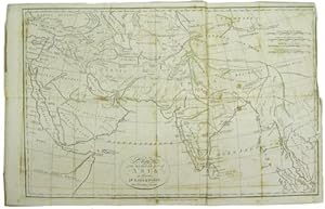
Map of the South East part of Asia for illustrating Dr. Robertson's Historical Disquisition &c
Published by Published as the Act directs. By T. Cadell Strand, London, 1791
Seller: Kaaterskill Books, ABAA/ILAB, East Jewett, NY, U.S.A.
Association Member: ABAA ILAB IOBA
Seller Rating:

35 x 55 cm. Removed from: Robertson, William, Historical Disquisition concerning the knowledge which the ancients had of India. A good copy, a few repaired tears and a few extra folds, some occasional foxing.
-

Hispania Romana.
Published by Longman,, [London]:, 1806
Seller: Nicholas D. Riccio Rare Books, ABAA, Florham Park, NJ, U.S.A.
Seller Rating:
Engraved black and white map, 10" x 16". Center fold, 1/2" margins, small archival tap repair at bottom margin, slight aging and toning; otherwise very good. A very nice impression. A map of Spain from the Roman period. Provides the Roman names for the regions, and illustrates important topographical features.
-
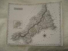
Cornwall
Seller: Roger Collicott Books, Widecombe in the Moor, DEVON, United Kingdom
Seller Rating:

Map
Map. Condition: Near Fine. Probably from Dugdale's The New British Traveller. Scilly Islands are shown in an inset over the north coast.
-
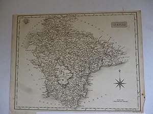
Devon
Publication Date: 1812
Seller: Roger Collicott Books, Widecombe in the Moor, DEVON, United Kingdom
Seller Rating:
Map
Map. Condition: Very Good. Uncoloured early nineteenth century map. Slightly age discoloured. Size : 245 x 190 mm. Batten and Bennett 79.1. They suggest 'loose sheet, probably from a part set'.
-
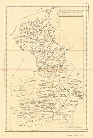
Condition: Good. Cambridgeshire county map by Samuel Neele 1810 old antique plan chart. Decorative antique copperplate map; Samuel Neele (1810). 38.0 x 25.5cm, 15 x 10 inches; this is a folding map. Condition: Good. There is nothing printed on the reverse side, which is plain.
-

Germany. North of the Mayne.
Published by EdinburghJohn Thomson. 1817, 1816
Seller: Robert Frew Ltd. ABA ILAB, London, United Kingdom
Association Member: ABA ILAB PBFA
Seller Rating:
Map
50.3 x 60 cm. Original colour. Double page map. Browned overall. Split without loss at lower edge of centrefold.
-
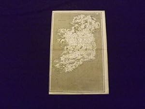
Ireland.
Published by Longman,, London:, 1808
Seller: Nicholas D. Riccio Rare Books, ABAA, Florham Park, NJ, U.S.A.
Seller Rating:
Engraved black and white map, 10" x 16". Center fold, left margin almost at border, slight toning and aging; otherwise very good. Detailed black and white map of Ireland, illustrating the counties and important topographical features.
-
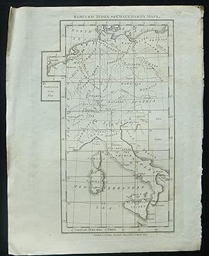
Reduced Index to Chauchard's Maps. Original copper Engraving
Published by John Stockdale, Picadilly, 1800
Art / Print / Poster
engraving area measures: 27 cm x 18 cm. Published by John Stockdale Piccadilly, 26 March 1800. Engraved by Neele. Druckgrafik.
-
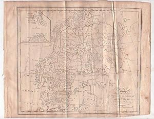
Map - Sweden, Norway and Denmark
Published by [1805], London, 1805
Seller: Renaissance Books, ANZAAB / ILAB, Dunedin, New Zealand
Association Member: ANZAAB ILAB
Seller Rating:
Map First Edition
Map. Condition: Fair. Dust Jacket Condition: No Dust Jacket. First Edition. Two fold lines. Creasing. Loss along lower corner, with loss of the lower part of the word "London" from the engraver's information, but not affecting the printed map within the black border. A 3/8" tear to blank margin on right border. ; Map titled "Map of Sweden Norway and Denmark from the best Authorities". 260 x 210mm. Engraved by [Samuel] Neele. With inset map of East Greenland. This map is from William Guthrie's "A New Geographical, Historical, and Commercial Grammar and Present State of the Several Kingdoms of the World", eighteenth edition, Montrose: Printed by D. Buchanan, 1805. ; Map.
-

Map - England and Wales
Published by [c1801-1805], London, 1801
Seller: Renaissance Books, ANZAAB / ILAB, Dunedin, New Zealand
Association Member: ANZAAB ILAB
Seller Rating:
Map First Edition
Map. Condition: Good. Dust Jacket Condition: No Dust Jacket. First Edition. Quite heavy foxing. Two fold lines. ; Map titled "Map of England & Wales from the best Authorities 1801". Dimensions: 260 x 210mm. Engraved by [Samuel] Neele. This map is from William Guthrie's "A New Geographical, Historical, and Commercial Grammar and Present State of the Several Kingdoms of the World", eighteenth edition, Montrose: Printed by D. Buchanan, 1805. ; Map.
-
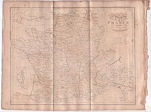
Map - France
Published by [1805], London, 1805
Seller: Renaissance Books, ANZAAB / ILAB, Dunedin, New Zealand
Association Member: ANZAAB ILAB
Seller Rating:
Map First Edition
Map. Condition: Good. Dust Jacket Condition: No Dust Jacket. First Edition. Quite heavy foxing. Two fold lines. ; Map titled "Map of France with its late Acquisitions". Dimensions: 270 x 210mm. With an inset map of Corsica. Engraved by [Samuel] Neele. This map is from William Guthrie's "A New Geographical, Historical, and Commercial Grammar and Present State of the Several Kingdoms of the World", eighteenth edition, Montrose: Printed by D. Buchanan, 1805. ; Map.
-
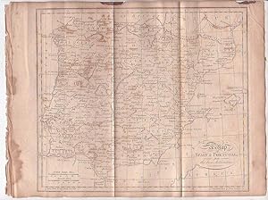
Map - Spain and Portugal
Published by [1805], London, 1805
Seller: Renaissance Books, ANZAAB / ILAB, Dunedin, New Zealand
Association Member: ANZAAB ILAB
Seller Rating:
Map First Edition
Map. Condition: Fair. Dust Jacket Condition: No Dust Jacket. First Edition. Moderate foxing. Some heavy foxing to inner blank margin. Two areas of staining to upper blank margin. Small 3/8" chip to upper blank margin. Two fold lines.; Map titled "A Map of Spain & Portugal from the best Authorities". Dimensions: 265 x 210mm. Engraved by Samuel Neele. This map is from William Guthrie's "A New Geographical, Historical, and Commercial Grammar and Present State of the Several Kingdoms of the World", eighteenth edition, Montrose: Printed by D. Buchanan, 1805. ; Map.
-

Map - Turkey in Europe with Hungary
Published by [1805], London, 1805
Seller: Renaissance Books, ANZAAB / ILAB, Dunedin, New Zealand
Association Member: ANZAAB ILAB
Seller Rating:
Map First Edition
Map. Condition: Good. Dust Jacket Condition: No Dust Jacket. First Edition. Moderate foxing. Two fold lines.; Map titled "A Map of Turkey in Europe with Hungary from the best Authorities". Dimensions: 255 x 210mm. Engraved by Samuel Neele. This map is from William Guthrie's "A New Geographical, Historical, and Commercial Grammar and Present State of the Several Kingdoms of the World", eighteenth edition, Montrose: Printed by D. Buchanan, 1805. ; Map.
-
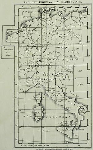
Condition: sehr guter Zustand. Deutsches Reich. Deutschland, Niederlande, Frankreich, Polen, �sterreich & Italien. Chauchard. Reduced Index to Chauchard's Maps.1800. Kupferstich. Landkarte, von Samuel John Neele. 25,0 x 15,6 cm (Darstellung), 29 x 22 cm (Blatt).Aus: Hippolyte Chauchard, A General Map of The Empire Of Germany, Holland, The Netherlands, Switzerland, The Grisons, Italy, Sicily, Corsica, And Sardinia (London: John Stockdale 1800). Hervorragender Zustand.Samuel John Neele (1758 - 1824 London). Kupferstecher in London. Titel oberhalb der Darstellung, unten Verlegeradresse und Sigantur Neele Sculp.t / Strand.
-
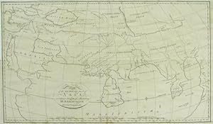
Map of the South East part of Asia according to Ptolemy for illustrating Dr. Robertson's Historical Disquisition &c
Published by [Printed for A. Strahan and T. Cadell] [Edinburgh] [E. Balfour], [London?], 1794
Seller: Kaaterskill Books, ABAA/ILAB, East Jewett, NY, U.S.A.
Association Member: ABAA ILAB IOBA
Seller Rating:
31 x 52 cm. Removed from: Robertson, William, Historical Disquisition concerning the knowledge which the ancients had of India. A very good copy, small marginal tear just touching a blank section of map.
-
![Seller image for A Hand-Coloured Map of Kent [1] for sale by Little Stour Books PBFA Member](https://pictures.abebooks.com/inventory/md/md1055345897.jpg)
A Hand-Coloured Map of Kent [1]
Published by Published by J. & J. Cunder, Albion, London . London 1815., 1815
Seller: Little Stour Books PBFA Member, Canterbury, United Kingdom
Association Member: PBFA
Seller Rating:
Hand-coloured map of Kent measuring 10'' x 8''. In Very Good clean and bright condition. Member of the P.B.F.A. KENT [Maps].
-
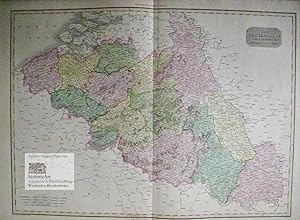
The Netherlands and the Countries to the Left Bank of the Rhine. Gro�e grenz- und fl�chenkolorierte Karte der Niederl�ndischen Provinzen und der linksrheinischen Anrainer. Altkolorierter Kupferstich von Samuel John Neele aus "Pinkerton's Modern Atlas" 1810
Published by London: Cadell & Davies Strand & Longman Hurst Rees Orme Erstausgabe, 1810
Seller: historicArt Antiquariat & Kunsthandlung, Wiesbaden-Breckenheim, Germany
Seller Rating:
Map First Edition Signed
1. gro�er Original-Kupferstich von Neele (in der Platte signiert) nach L. Hebert unter der Aufsicht von Pinkerton auf schwerem B�ttenblatt, von alter Hand sehr gut grenz- und fl�chenkoloriert, Blattgr��e ca. 56,5 x 78,5 cm (H�he x Breite), gegl�ttete Mittelfalz, saubere und bemerkenswert gut erhaltene Karte der ersten Ausgabe dieses hervorragenden Atlanten, clean copy in very good condition with intact margins, rare first edition - gro�er und/oder schwerer Artikel mit zus�tzlichen Kosten f�r Versand und Versicherung - heavy and/or oversized item with additional costs for shipping and insurance - please ask us before you order this article 2100 gr.
-

An Interesting Letter to a Mr Dodds from the Engraver Samuel John Neele With Regards to Copper Plates for Probably a Book on The Battle of Waterloo.
Published by UK, 1816
Manuscript / Paper Collectible First Edition Signed
Paper. Condition: Good. First Edition. An Interesting Letter to a Mr Dodds from the Engraver Samuel John Neele With Regards to Copper Plates for Probably a Book on The Battle of Waterloo. Dated 1816. Samuel John Neele (1758-1824) was an important British engraver and cartographer who is known to have produced a substantial body of work including both maps and portraits. He operated a print shop in London with his sons between 1782 and 1833. From a autograph book kept by A. P. Watt (1834-1914), founder of A. P. Watt & Son in 1875, the world's first literary agents. Size is 170m x 105mm. Condition is good. Light folding creases. More images can be taken upon request. Ref18423. Signed by Author(s).
-
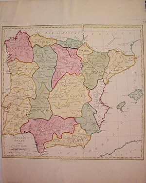
Present Spain and Portugal
Published by T. Stackhouse, London, 1785
Seller: Argosy Book Store, ABAA, ILAB, New York, NY, U.S.A.
Seller Rating:
unbound. Condition: very good. Map. Engraving with hand color. Image measures 14.5" x 15.5". Nice map of the Iberian Peninsula. Left and right margins are cropped, very small tears to bottom edge and small chip to lower right corner.
