Order Total (1 Item Items):
Shipping Destination:

Homann, J B (270 results)
Skip to main search results
Product Type
- All Product Types
- Books (152)
- Magazines & Periodicals
- Comics
- Sheet Music
- Art, Prints & Posters (26)
- Photographs
- Maps (92)
-
Manuscripts &
Paper Collectibles
Condition
Binding
Collectible Attributes
- First Edition
- Signed
- Dust Jacket
- Seller-Supplied Images (245)
- Not Printed On Demand
Seller Location
Seller Rating
-
Programmieren Mit Maple V (German Edition): Release 4
Published by Springer Berlin Heidelberg 01.1996., 1996
ISBN 10: 3540605444ISBN 13: 9783540605447
Book
paperback. Condition: Sehr gut. Auflage: 1. 416 Seiten 9783540605447 Wir verkaufen nur, was wir auch selbst lesen w�rden. Sprache: Deutsch Gewicht in Gramm: 656.
More buying choices from other sellers on AbeBooks
Used offers from � 27.25
-
Hardcover. Condition: very good. Coppermap, edited by Homann Heirs, anno 1789, size of the leaf: 52x62 cm., waterstained, cutted, cracs on margins.
-
Hardcover. Condition: very good. Zum Aufruf kommt EINE SCH�NE ALTKOLORIERTE KARTE DES RHEINLAUFS VON DER QUELLE BIS ZUR M�NDUNG, mit kleiner Insetkarte "vom Ursprung des Rheins". 62 x 48cm, gering gebr�unt, hinterlegte Fehlstelle, hinterlegte Mittelfalz.
-
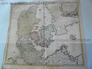
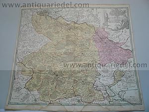
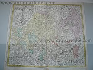
Th�ringen/Thuringia Tabula Homann Erben, anno 1729, altkoloriert
Published by Homann J.B.,1664-1724, 1724
Hardcover. Condition: very good. Th�ringen/Thuringia Tabula Homann Erben, anno 1729, altkoloriert Th�ringen/Thuringia Tabula Homann Erben, anno 1729, altkoloriert, Blattma�: 55x66 cm., Mittelfalz restauriert mit minimalem Bildverlust, kaum zu erkennen.
-

Gouvernement General Picardie, Homann Heirs anno 1746, plate siz
Published by Homann J.B.,1664-1724, 1724
Hardcover. Condition: very good. Gouvernement General Picardie, Homann Heirs anno 1746, plate size: 55,5 x 48,0 cm., little brownish and waterstained. original colours---ONE OF THE FIRST ROAD MAPS--- Picardy a historic region in north France. The map shows the General Government Picardie, Amiens and Artois, and the borders of the Netherlands. A figurative title cartouche is at the top right identifies the Homann heirs as the editor and refers to Guillaume De L'isle as a contributor for this map. The framed cartouche has products of the region and a depiction of fishing at the bottom, the economic mainstays of the region. A seated figure on the edge of the cartouche carries a cornucopia a symbol of happiness, fertility, abundance and prosperity. A detailed legend is on the bottom left. French standards of longitude are used. Historian and geographer Claude De L'Isle (1644-1720) was a prominent figure in French cartography. His son Guillaume (1675-1726) would become a renown cartographer in his own right and at 27 years old was a member of the Acad�mie Royale des Sciences. The Homann Heirs (Homann Erben) was a company that continued the work of legendary cartographer Johann Baptist Homann (1664-1724) who was at one time geographer of the Holy Roman Empire. The Heirs were in business until from 1730 -1852. Reference Tooley's Dictionary of Mapmaker, Early World Press, 2004, p361.
-

Eisenbahnbau, Tunnelbau, Stadt und Untergrundbahnen, Bergbau, (Eisenbahnbalkenbr�cken; Eisenbahnschwellen; Leitungen sonstige Anwendungen im Eisenbahnwesen; Tunnelbau; Tunnel, L�ftungsanlagen; Stadt und Untergrundbahnen; Bergbau),
Published by Verlag von Wilhelm Ernst & Sohn, Berlin, 1912
Book
Condition: Gut. 2. neubearb. Auflage, mit 1093 Textabbildungen, 511 S., Halbleder, R�cken goldgepr�gt und leicht berieben, gutes Ex., Name auf Vorsatz, (= Handbuch f�r Eisenbetonbau in zw�lf B�nden, Siebenter Band; Hg. Dr. Ing. F. vom Emperger),.
-
Hardcover. Condition: very good. Braunschweig, Karte Homann anno 1762 Kupferkarte, verlegt von Homann Erben, anno 1762, fl�chenkolriert, diverse, hinterlegte L�suren. Karte: 47 x 54 cm.
-

20 S. ohne Einband, ca. 52 x 33 cm, mit L�suren, Titel fehlt, erstes Blatt stark angestraubt.
-
Pas de couverture. Condition: Assez bon. Um 1720; Altkolorierter Kupferstich, in 8 Segmenten auf Leinen aufgezogen; 60,5X50,5 cm; am Rande leicht fleckig, leichte Benutzungspuren, Druck der Kartusche in wenig schwach, sonst gut;
-
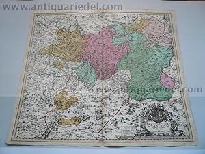
Ducatus Luxemburgi tam in Maiores quam ejusdem Ditiones accurate distinctus et exhibitus.
Published by N�rnberg Homann, 1720
Map
Pas de couverture. Condition: Satisfaisant. Carte originale grav�e, anciennement colori�e, couleur et impression l�g�rement pass�e; carte compl�te avec pliures, croisements de plis avec petits trous, pliures et quelques petites d�chirures sur la bordure qui est compl�te, cependant la marge ext�rieure blanche a �t� coup�e; verso avec traces d'usage; dans l'ensemble une carte l�g�rement pass�e et bien conserv�e avec tr�s l�gers manques; 48X58 cm:
-
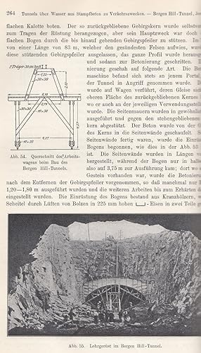
Eisenbahnbau, Tunnelbau, Stadt- und Untergrundbahnen, Bergbau. -
Published by Berlin: Ernst ,, 1912
xvi, 511 (4) Seiten, farbiger Kopfschnitt, blind- und goldgepr�gter OLnbd., 28 x 16 cm. 2., neubearbeitete Auflage. - (= Handbuch f�r Eisenbetonbau, Band 7). - �ber Eisenbahnbalkenbr�cken, Eisenbahnschwellen, Leitungen, Sonstige Anwendungen im Eisenbahnwesen, Tunnelbau, Tunnel-L�ftungsanlagen, Stadt- und Untergrundbahnen sowie Bergbau. - Mit 1093 Abbildungen im Text. - Etwas berieben, sonst und insgesamt gutes Exemplar.
-
Europa zwischen Ordnungswettbewerb und Harmonisierung
Published by Springer Berlin Heidelberg, 2012
ISBN 10: 3642799760ISBN 13: 9783642799761
Book
Condition: New.
-
Hardcover. Condition: very good. please read german text.
-
Hardcover. Condition: very good. Kriegskarte von Schlesien 1741, Homann Erben, Blattma�: 175x125 mm., gering gebr�unt. Zeigt Schlesien mit dem Oderlauf und Breslau im Norden und M�hren im S�den.
-
Hardcover. Condition: very good. please read german textKupferkarte, verlegt von J. B. Homann, anno 1720, Blattma� 52 x 60 cm., altkoloriert, gedruckt auf dickem Papier, gering gebr�unt, am unteren Rand wasserfleckig, knapp �ber die Einfassungslinie hinausgehend, hinter Passepartout montiert, kaum zu erkennen. Im Norden der Elbelauf, im S�den Braunschweig mit Hannover als Begrenzung.
-
Hardcover. Condition: Befriedigend. Gesamtansicht, verlegt bei Homanns Erben, anno 1784, an den R�ndern etwas wasserfleckig, ansonsten gut erhalten, gedruckt auf dickem Papier. Blattma�: 53x63 cm.
-
. Altkolorierter Kupferstich. 45 cm x 55 cm. N�rnberg * Unten links Titelkartusche mit Meilenanzeiger (K).
-
Eisenbahnbau, Tunnelbau, Stadt- und Untergrundbahnen, Bergbau.
Published by Ernst & Sohn, Berlin., 1912
Seller: Antiquariat Roland G�gler, Leutkirch, Germany
Seller Rating:

Zweite Auflage. 26,9 x 18,8 cm. XVI, 511 Seiten, 2 Bl., mit 1093 Abbildungen. Original-Halbleder mit goldenem R�ckentitel. Einband angestaubt, gebr�unt und fingerfleckig, R�cken etwas berieben, Kanten st�rker berieben, Bibliothekssignatur am R�cken. Stempel auf Vortitel, Titel und letztem Blatt, sonst innen gut und sauber. (Handbuch f�r Eisenbetonbau Band 7).
-
Baden W�rttemberg Karte, Reprint nach dem Original von 1710, handcoloriert.
Published by Kunstverlag Totius Mundi ohne Jahr., Wien.
Seller: Buecherstube Eilert, Versandantiquariat, Kornwestheim, LB, Germany
Seller Rating:
94 x 57 cm Bildformat mit breitem Rand. ungefaltet. Reprint auf B�tten handkoloriert. Sehr sch�ne Farben. Sehr guter Zustand. kann nur in der Rolle verschickt werden 15, Sprache: lat.
-
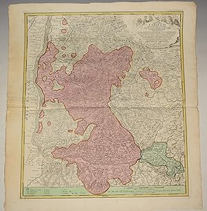
Regni Bohemiae, duc. Silesiae Marchionatuum Moraviae et Lusatiae. Tabula Generalis - Teilcolorierte Karte im Kupferstich
Book
Homann, (N�rnberg, 1748). Plattenma�: ca. 63 x 55 cm, hinter Glas, im Passepartout, in gold-wei�-farbenem Holzrahmen (ca. 68,7 x 62,8 cm), (Rahmen gering berieben/Karte teils gering gebr�unt)---Verlag: Homann Verlag: Homann - Carte des Etats de Boheme, avec le Souverain Duce de Silesie, publiee par les Heritiers de Homan l'An 1748 - 2635 Gramm.
-
IMP.CAES. CAROLO VI. . PROVINCIA BRISGOIA . Original Engraved Map of the Schwarzwald region in southwest Germany between Basel, Lahr, Rottweil and Schaffhausen with decrative cartouche. Imp. Caes. Carolo VI. Augusto Pio Victori Gentis suae Sideri Felicissimo Chorographiam Hanc Exhibentem Primar. Regionum Habspurgicar. Situm Positumq. Brevibus Exterarum Ditionum Intervallis ut Permistum et Implicatum ita Variis Turbis Expositum Necnon Ultimos Imperii Germ. Terminos Perpetua Transivexatione Agitatos Anique Fidei et Invictae Testes Pietatis Supplex Dicat Provincia Brisgoia Aust. Ant. MDCCXVIII. Cum Privilegio Sac. Caes. Majestatis - Schwarzwald Basel Rhein Freiburg im Breisgau Villingen-Schwenningen Karte map
Published by 1718, 1718
Seller: PROCTOR / THE ANTIQUE MAP & BOOKSHOP, DORCHESTER, United Kingdom
Association Member: PBFA
Seller Rating:
Map
Unmounted. Total Size 22.5 x 25 inches. In very good condition. SLightly tanned to margin edges. Hand coloured,
-
Arena martis in Belgio qua provinciae. Belgien. org. altkol. Kupferstichkarte von Homann.
Published by N�rnberg, ca. ., 1720., 1720
48 x 57 cm, fig�rliche Kartusche ordentlich.
-
Galliae sive Franciae. Frankreich orig. altkol. KUpferstichkarte von Homann.
Published by N�rnberg, ca., ., 1720
48 x 57 cm, fig�rliche Kartusche mit 12 Wappen, --angestraubt, R�ckseite im Falz in der Mitte und am Rand mit Papier beklebt, teils gering fleckig, mit kl. Schaden in der Mitte , trotz der M�ngel noch ordentlich.
-
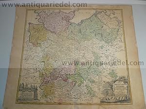
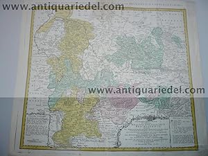
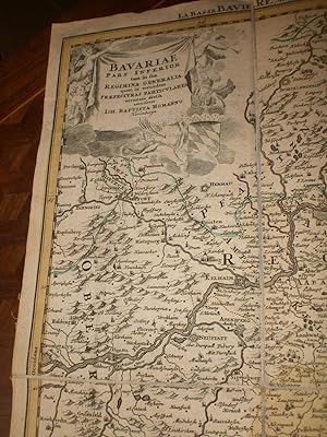
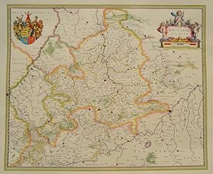
Bavariae/Altbayern,anno 1720, Homann, altkoloriert Kupferkarte,
Published by Homann J.B.,1664-1724, 1724
Hardcover. Condition: very good. Bavariae/Altbayern,anno 1720, Homann, altkoloriert Kupferkarte, verlegt d. J.B.Homann, anno 1720, Blattma�: 52 x 60 cm. Die Karte zeigt Altbayern mit Innsbruck im S�den, Wels im Osten, Bamberg im Nordwsten und N�rdlingen im Westen. Sch�nes Altkolorit, am linken Plattenrand eine kleine Reparatur mit minimalstem Bildverlust; einfach zu restaurieren.
-
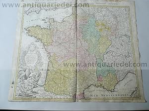
Hardcover. Condition: very good. France, anno 1741, Homann Heirs/De L Isle Generalmap of France, edited by Homann Heirs/De L Isle, anno 1741, old colours, on margins brownish, waterstained, on below centerfold some restored Wormholes (2x2 cm.).
-
Carte D Artois et des Environs Vel Mappa Specalis Comitatus Artesiae in qua simul Terrae Iurisdictionales.de l Isle designata. Recudentibus Homannianis Heredib.
Published by Homann Heirs 1740-50, N�rnberg, 1740
Seller: Antiquariat Reinhold Berg eK Inh. R.Berg, Regensburg, Germany
Seller Rating:

Map
Other. Original antique copper engraving, hand colored and wash when published. Ornated in the upper right corner with a large allegoric title cartouche, as well a small mileage scale in the upper left corner. Fine detailed engraved map showing the duchy of Artois with its surroundings. With many place names and details like streets, woods, mountains, rivers, lakes etc. Still in very good condition, a minor gluestaining at the centre-fold. 482 by 570mm (19 by 22 inches).
-
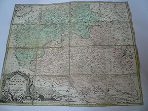
Znoymensis/Iglaueinsis,anno 1720, map Homann J.B., old colours C
Published by Homann J.B.,1664-1724, 1724
Map
Kein Einband. Condition: Befriedigend. Znoymensis/Iglaueinsis,anno 1720, map Homann J.B., old colours Coppermap, edited by Homann J.B., anno 1720, size of the leaf: 50x58 cm., mounted on canvas, little brownish. The map shows the southern part of Moravia/Morava/M�hren.
-
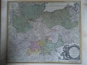
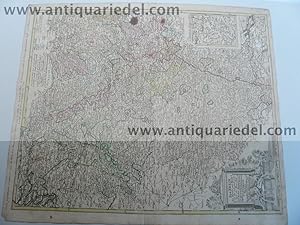
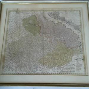
Circulus Saxoniae Inferioris in omnes fuos Status et Principatus accumate divisus ex conatibus Ioh. Bapt. Homanni Norimberga - Teilkolorierte Karte im Kupferstich
Book
(um 1720). Ma�e: ca. 56,3 x 47,3 cm, unten rechts mit allegorischer Kartusche, im Passepartout, hinter Glas, in schlichter Holzleiste (ca. 72,1 x 65,2 cm), (Passepartout teils leicht gebr�unt bzw. fleckig)---Verlag: Ohne Verlag: Ohne - sonst gute Erhaltung - 4200 Gramm.
-
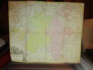
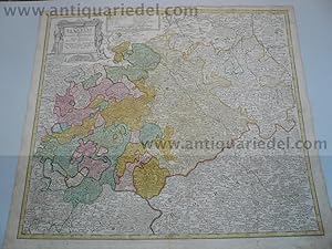
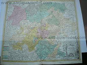
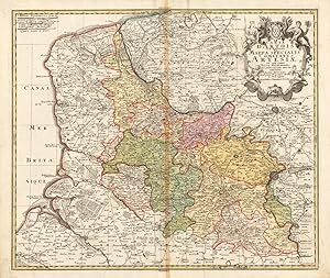
Hardcover. Condition: very good. Please read german TextKupferkarte, verlegt von Homann Erben, anno 1734, altkoloriert, Blattma�: 52 x 60 cm., gering gebr�unt. Die Karte wird begrenzt durch Schweinfurt im S�dwesten, durch Pilsen im S�den, Frankfurt/Oder im Nordosten, Berlin im Norden und durch Goslar im Nordwesten. Am unteren Kartenrand, ausserhalb der Darstellung zwei L�cher, verursacht durch Wurmfra�.
-
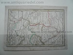
Kein Einband. Condition: Gut. Hessen-Pfalz,anno 1720, Karte Homann, altkoloriert Kupferkarte, verlegt von Homann J. B., anno 1720, altkoloriert, Blattma�: 52 x 60 cm., gering fleckig.