
Order Total (1 Item Items):
Shipping Destination:

De Fer, Nicolas (Over 1,000 results)
Skip to main search results
Product Type
- All Product Types
- Books (372)
- Magazines & Periodicals
- Comics
- Sheet Music
- Art, Prints & Posters (367)
- Photographs
- Maps (271)
-
Manuscripts &
Paper Collectibles
Condition
Binding
Collectible Attributes
- First Edition (23)
- Signed (6)
- Dust Jacket (2)
- Seller-Supplied Images (938)
- Not Printed On Demand (995)
Free Shipping
Seller Location
Seller Rating
-

Introduction la Geographie Avec une Description Historique sur Touttes les Parties de la Terre Classic Reprint
Published by Forgotten Books, 2018
ISBN 10: 0282394990ISBN 13: 9780282394998
Book
PAP. Condition: New. New Book. Shipped from UK. Established seller since 2000.
More buying choices from other sellers on AbeBooks
New offers from � 18.29
-
![Seller image for Quatriesme Planche - Pentagone fortifi� a simples bastions [Fortified pentagon with simple bastions] for sale by Antiqua Print Gallery](https://pictures.abebooks.com/inventory/md/md31102247571.jpg)
Quatriesme Planche - Pentagone fortifi� a simples bastions [Fortified pentagon with simple bastions]
Publication Date: 1705
Art / Print / Poster
Condition: Good. 'Quatriesme Planche - Pentagone fortifi�'. Fortified pentagon. DE FER 1705. Early 18th century copperplate print; Nicolas de Fer (1705). 15.0 x 21.0cm, 6 x 8.25 inches. Condition: Good. Light spotting. There is nothing printed on the reverse side, which is plain.
-
![Seller image for Exagone fortifi� avec toutes sortes de dehors [Fortified hexagon with various external defences] for sale by Antiqua Print Gallery](https://pictures.abebooks.com/inventory/md/md31102246737.jpg)
Exagone fortifi� avec toutes sortes de dehors [Fortified hexagon with various external defences]
Publication Date: 1705
Art / Print / Poster
Condition: Good. 'Exagone fortifi�'. Fortified defensive hexagon. DE FER 1705 old antique print. Early 18th century copperplate print; Nicolas de Fer (1705). 21.5 x 29.0cm, 8.5 x 11.5 inches. Condition: Good. Light spotting. There is nothing printed on the reverse side, which is plain.
-
Mont Midi, ville forte, des Pays Bas, dans le Duche de Luxembourg [Montm�dy]
Publication Date: 1705
Map
Condition: Good. 'Mont Midi'. Montm�dy fortified town/city plan. Meuse. DE FER 1705 old map. Early 18th century copperplate map; Nicolas de Fer (1705). 16.5 x 29.5cm, 6.5 x 11.5 inches. Condition: Good. There is nothing printed on the reverse side, which is plain.
-
Condition: Good. 'Ratzebourg'. Ratzeburg 1693 bombardment. Schleswig-Holstein. DE FER 1705 map. Early 18th century copperplate map; Nicolas de Fer (1705). 19.5 x 27.0cm, 7.75 x 10.5 inches. Condition: Good. There is nothing printed on the reverse side, which is plain.
-
Condition: Good. 'Prats de Moliou'. Prats-de-Mollo-la-Preste town/city plan. DE FER 1705 map. Early 18th century copperplate map; Nicolas de Fer (1705). 19.5 x 27.0cm, 7.75 x 10.5 inches. Condition: Good. There is nothing printed on the reverse side, which is plain.
-
Condition: Poor. 'Verue'. Verrua Savoia. Fortifed town/city plan. Italy. DE FER 1705 old map. Early 18th century copperplate map; Nicolas de Fer (1705). 21.5 x 30.5cm, 8.5 x 12 inches. Condition: Poor: A vertical tear has been repaired verso and is quite prominent. Light creasing. The map has been cleaned, which has somewhat lightened the tone of the ink. There is nothing printed on the reverse side, which is plain.
-
Condition: Good. 'Sas de Gand'. Sas van Gent. Fortified town/city plan. Belgium. DE FER 1705 map. Early 18th century copperplate map; Nicolas de Fer (1705). 22.5 x 31.0cm, 8.75 x 12 inches. Condition: Good. Light spotting. There is nothing printed on the reverse side, which is plain.
-
Condition: Good. Forts Louis Kenoque Knokke St-Fran�ois Valli�res Dunkirk Diksmuide. FER 1705 map. Early 18th century copperplate map; Nicolas de Fer (1705). 21.5 x 31.5cm, 8.5 x 12.5 inches. Condition: Good. The map has been cleaned, which has somewhat lightened the tone of the ink. There is nothing printed on the reverse side, which is plain.
-
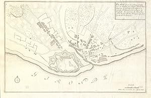
Condition: Good. Blaye. Plan of town/city & fortifications. Gironde. DE FER 1705 old map. Early 18th century copperplate map; Nicolas de Fer (1705). 22.5 x 35.0cm, 9 x 13.75 inches. Condition: Good. The map has been cleaned, which has somewhat lightened the tone of the ink. There is nothing printed on the reverse side, which is plain.
-
Juliers, ville d'Allemagne, capitale du Duch� de m�me nom au Duc de Neubourg [J�lich]
Publication Date: 1705
Map
Condition: Good. 'Juliers, ville d'Allemagne '. J�lich fortified town/city plan. DE FER 1705 map. Early 18th century copperplate map; Nicolas de Fer (1705). 19.0 x 23.0cm, 7.5 x 9 inches. Condition: Good. There is nothing printed on the reverse side, which is plain.
-
L'Abbaye de St. Martin; pres Treves [St Martin's Abbey (Abtei St. Martin/Martinskloster), Trier]
Publication Date: 1705
Map
Condition: Good. 'L'Abbaye de St. Martin'. Abtei St. Martin/Martinskloster Trier. DE FER 1705 map. Early 18th century copperplate map; Nicolas de Fer (1705). 23.0 x 31.5cm, 9 x 12.5 inches. Condition: Good. Marginal tear repaired verso. There is nothing printed on the reverse side, which is plain.
-
Condition: Fair. 'Charle-Mont'. Plam of the Fort de Charlemont, Ardennes. DE FER 1705 old map. Early 18th century copperplate map; Nicolas de Fer (1705). 21.0 x 35.0cm, 8.25 x 13.75 inches. Condition: Fair: The map has been cleaned, which has somewhat lightened the tone of the ink. Light crease. There is nothing printed on the reverse side, which is plain.
-
Condition: Good. 'Campredon'. Camprodon. Fortifed town/city plan. Spain. DE FER 1705 old map. Early 18th century copperplate map; Nicolas de Fer (1705). 20.0 x 26.5cm, 7.75 x 10.5 inches. Condition: Good. There is a large, decorative watermark in the centre of the paper. There is nothing printed on the reverse side, which is plain.
-
Condition: Good. 'Belle-Garde'. Fort de Bellegarde plan, Le Perthus, France. DE FER 1705 map. Early 18th century copperplate map; Nicolas de Fer (1705). 20.0 x 26.5cm, 7.75 x 10.5 inches. Condition: Good. There is nothing printed on the reverse side, which is plain.
-
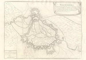
Condition: Fair. Valenciennes. Plan of town/city & fortifications. Nord. DE FER 1705 old map. Early 18th century copperplate map; Nicolas de Fer (1705). 22.0 x 31.5cm, 8.5 x 12.5 inches. Condition: Fair: The map has been cleaned, which has somewhat lightened the tone of the ink. There are a number of small closed tears in the right hand margin which have been repaired verso. There is nothing printed on the reverse side, which is plain.
-
![Seller image for Veue de Verue, ville de Piemont, situ�e pres de la Rivi�re du Po [View of Verrua Savoia, in Piedmont, situated near the River Po] for sale by Antiqua Print Gallery](https://pictures.abebooks.com/inventory/md/md31102253921.jpg)
Veue de Verue, ville de Piemont, situ�e pres de la Rivi�re du Po [View of Verrua Savoia, in Piedmont, situated near the River Po]
Publication Date: 1705
Art / Print / Poster
Condition: Good. 'Veue de Verue, ville de Piemont'. View of Verrua Savoia, Piedmont. DE FER 1705. Early 18th century copperplate print; Nicolas de Fer (1705). 13.5 x 22.0cm, 5.25 x 8.5 inches. Condition: Good. Spot. There is nothing printed on the reverse side, which is plain.
-
Introduction ? la fortification par de Fer 1723
Published by Facsimile Publisher
ISBN 10: 9333454489ISBN 13: 9789333454483
Book
Condition: New. pp. 397.
-
Condition: Good. 'Puicerda'. Puigcerda. Fortifed town/city plan. Spain. DE FER 1705 old map. Early 18th century copperplate map; Nicolas de Fer (1705). 20.0 x 26.0cm, 7.75 x 10.25 inches. Condition: Good. There is nothing printed on the reverse side, which is plain.
-
Condition: Good. 'Hombourg'. Hombourg-Haut. Fortifed town/city plan. Moselle. DE FER 1705 map. Early 18th century copperplate map; Nicolas de Fer (1705). 22.0 x 31.0cm, 8.5 x 12.25 inches. Condition: Good. Light spotting. The map has been cleaned, which has somewhat lightened the tone of the ink. There is nothing printed on the reverse side, which is plain.
-
Condition: Good. 'Philippe-Ville'. Philippeville. Fortified town/city plan. DE FER 1705 old map. Early 18th century copperplate map; Nicolas de Fer (1705). 19.5 x 26.5cm, 7.75 x 10.5 inches. Condition: Good. The map has been cleaned, which has somewhat lightened the tone of the ink. There is nothing printed on the reverse side, which is plain.
-
Condition: Good. 'Defaite de l'arm�e des alliez ' Battle of Landen 1693. DE FER 1705 old map. Early 18th century copperplate map; Nicolas de Fer (1705). 21.0 x 30.0cm, 8.25 x 12 inches. Condition: Good. There is nothing printed on the reverse side, which is plain.
-
Condition: Good. 'Schlestat'. S�lestat. Fortifed town/city plan. Bas-Rhin. DE FER 1705 old map. Early 18th century copperplate map; Nicolas de Fer (1705). 20.5 x 31.0cm, 8 x 12 inches. Condition: Good. There is nothing printed on the reverse side, which is plain.
-
Condition: Fair. 'Le combat de Steenkerke'. Battle of Steenkerque1692. Belgium. DE FER 1705 map. Early 18th century copperplate map; Nicolas de Fer (1705). 20.0 x 31.0cm, 8 x 12.25 inches. Condition: Fair: There is a repaired tear across the lower left hand corner of the map. The map has been cleaned, which has somewhat lightened the tone of the ink. There is nothing printed on the reverse side, which is plain.
-
Condition: Good. 'Environs de Strasbourg'. Strasbourg environs. Bas-Rhin. DE FER 1705 old map. Early 18th century copperplate map; Nicolas de Fer (1705). 20.5 x 28.0cm, 8 x 11 inches. Condition: Good. Light crease in margin. There is nothing printed on the reverse side, which is plain.
-
Condition: Fair. 'Nieuport'. Nieuwpoort. Fortifed town/city plan. Belgium. DE FER 1705 old map. Early 18th century copperplate map; Nicolas de Fer (1705). 23.0 x 32.5cm, 9 x 12.75 inches. Condition: Fair: There is a repaired tear in the lower left margin which extends c.8cm inside the border of the map. The tear is visible, but not particularly prominent. The map has been cleaned, which has somewhat lightened the tone of the ink. There is nothing printed on the reverse side, which is plain.
-
Condition: Good. Cond�-sur-l'Escaut. Plan of town/city & fortifications. Nord. DE FER 1705 map. Early 18th century copperplate map; Nicolas de Fer (1705). 21.0 x 31.0cm, 8.25 x 12 inches. Condition: Good. There is nothing printed on the reverse side, which is plain.
-
Condition: Good. Huy. Plan of town/city & fortifications. Belgium. DE FER 1705 old antique map. Early 18th century copperplate map; Nicolas de Fer (1705). 17.0 x 30.5cm, 6.75 x 12 inches. Condition: Good. There is nothing printed on the reverse side, which is plain.
-
Condition: Good. 'Les environs de Treves et de Consarbruch'. Trier Konz. Germany. DE FER 1705 map. Early 18th century copperplate map; Nicolas de Fer (1705). 21.5 x 31.5cm, 8.5 x 12.25 inches. Condition: Good. Light spotting. There is nothing printed on the reverse side, which is plain.
-
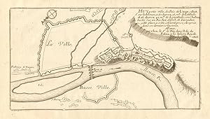
Condition: Good. Cambrai. Plan of town/city & fortifications. Nord. DE FER 1705 old antique map. Early 18th century copperplate map; Nicolas de Fer (1705). 22.5 x 31.5cm, 8.75 x 12.5 inches. Condition: Good. There is nothing printed on the reverse side, which is plain.
![Seller image for Mont Midi, ville forte, des Pays Bas, dans le Duche de Luxembourg [Montm�dy] for sale by Antiqua Print Gallery](https://pictures.abebooks.com/inventory/md/md31102247577.jpg)
![Seller image for Ratzebourg [Ratzeburg] for sale by Antiqua Print Gallery](https://pictures.abebooks.com/inventory/md/md31102247583.jpg)
![Seller image for Prats de Moliou [Prats-de-Mollo-la-Preste] for sale by Antiqua Print Gallery](https://pictures.abebooks.com/inventory/md/md31102252041.jpg)
![Seller image for Verue [Verrua Savoia] for sale by Antiqua Print Gallery](https://pictures.abebooks.com/inventory/md/md31102245761.jpg)
![Seller image for Sas de Gand [Sas van Gent] for sale by Antiqua Print Gallery](https://pictures.abebooks.com/inventory/md/md31102246739.jpg)
![Seller image for Le Fort Louis, Le Fort de la Kenoque, Le Fort Francois [Fort Louis & Fort Saint-Fran�ois (now known as Fort Valli�res, both situated on the canal between Dunkirk/Dunkerque & Bergues - Fort Knokke / Fort de Cnocke / Knocque / Knocke (Diksmuide, Belgium)] for sale by Antiqua Print Gallery](https://pictures.abebooks.com/inventory/md/md31102247573.jpg)
![Seller image for Juliers, ville d'Allemagne, capitale du Duch� de m�me nom au Duc de Neubourg [J�lich] for sale by Antiqua Print Gallery](https://pictures.abebooks.com/inventory/md/md31102250075.jpg)
![Seller image for L'Abbaye de St. Martin; pres Treves [St Martin's Abbey (Abtei St. Martin/Martinskloster), Trier] for sale by Antiqua Print Gallery](https://pictures.abebooks.com/inventory/md/md31102250076.jpg)
![Seller image for Charle-Mont [Fort de Charlemont] for sale by Antiqua Print Gallery](https://pictures.abebooks.com/inventory/md/md31102252033.jpg)
![Seller image for Campredon [Camprodon] for sale by Antiqua Print Gallery](https://pictures.abebooks.com/inventory/md/md31102252042.jpg)
![Seller image for Belle-Garde [Le Fort de Bellegarde, Le Perthus] for sale by Antiqua Print Gallery](https://pictures.abebooks.com/inventory/md/md31102252949.jpg)
![Seller image for Puicerda [Puigcerda] for sale by Antiqua Print Gallery](https://pictures.abebooks.com/inventory/md/md31102245763.jpg)
![Seller image for Hombourg [Hombourg-Haut] for sale by Antiqua Print Gallery](https://pictures.abebooks.com/inventory/md/md31102246738.jpg)
![Seller image for Philippe-Ville [Philippeville] for sale by Antiqua Print Gallery](https://pictures.abebooks.com/inventory/md/md31102246740.jpg)
![Seller image for Defaite de l'arm�e des alliez dans leurs camp de Neerwinde [The Battle of Landen (or Neerwinden), 29 July 1693] for sale by Antiqua Print Gallery](https://pictures.abebooks.com/inventory/md/md31102246741.jpg)
![Seller image for Schlestat [S�lestat] for sale by Antiqua Print Gallery](https://pictures.abebooks.com/inventory/md/md31102246743.jpg)
![Seller image for Le combat de Steenkerke [Battle of Steenkerque(also spelled SteenkerkeorSteenkirk), 3 August 1692 (the text gives a date of 5 August 1692)] for sale by Antiqua Print Gallery](https://pictures.abebooks.com/inventory/md/md31102247576.jpg)
![Seller image for Environs de Strasbourg [Environs of Strasbourg] for sale by Antiqua Print Gallery](https://pictures.abebooks.com/inventory/md/md31102247582.jpg)
![Seller image for Nieuport [Nieuwpoort] for sale by Antiqua Print Gallery](https://pictures.abebooks.com/inventory/md/md31102249464.jpg)
![Seller image for Cond� [Cond�-sur-l'Escaut] for sale by Antiqua Print Gallery](https://pictures.abebooks.com/inventory/md/md31102249465.jpg)
![Seller image for Les environs de Treves, et de Consarbruch [Environs of Trier and Konz] for sale by Antiqua Print Gallery](https://pictures.abebooks.com/inventory/md/md31102252036.jpg)
![Seller image for Cambrai [Cambrai] for sale by Antiqua Print Gallery](https://pictures.abebooks.com/inventory/md/md31102252927.jpg)