Order Total (1 Item Items):
Shipping Destination:

Brion De La Tour, Louis (184 results)
Skip to main search results
Product Type
- All Product Types
- Books (67)
- Magazines & Periodicals
- Comics
- Sheet Music
- Art, Prints & Posters (18)
- Photographs
- Maps (99)
-
Manuscripts &
Paper Collectibles
Condition
Binding
Collectible Attributes
Free Shipping
Seller Location
Seller Rating
-

Atlas, Et Tables �l�mentaires de G�ographie, Ancienne Et Moderne (Histoire) (French Edition)
Published by Hachette Livre Bnf, 2016
ISBN 10: 2019554631ISBN 13: 9782019554637
Book
Condition: New.
-

Baron de Las Casas (Histoire) (French Edition)
Published by Hachette Livre Bnf, 2014
ISBN 10: 2013482809ISBN 13: 9782013482806
Book
Condition: New.
More buying choices from other sellers on AbeBooks
New offers from � 19.12
-
![Seller image for Atlas itineraire portatif de l'Europe (1776) [LeatherBound] for sale by True World of Books](https://pictures.abebooks.com/inventory/md/md31618321112.jpg)
Atlas itineraire portatif de l'Europe (1776) [LeatherBound]
Publication Date: 2023
Book Print on Demand
LeatherBound. Condition: New. LeatherBound edition. Condition: New. Reprinted from 1776 edition. Leather Binding on Spine and Corners with Golden leaf printing on spine. Bound in genuine leather with Satin ribbon page markers and Spine with raised gilt bands. A perfect gift for your loved ones. NO changes have been made to the original text. This is NOT a retyped or an ocr'd reprint. Illustrations, Index, if any, are included in black and white. Each page is checked manually before printing. As this print on demand book is reprinted from a very old book, there could be some missing or flawed pages, but we always try to make the book as complete as possible. Fold-outs, if any, are not part of the book. If the original book was published in multiple volumes then this reprint is of only one volume, not the whole set. Sewing binding for longer life, where the book block is actually sewn (smythe sewn/section sewn) with thread before binding which results in a more durable type of binding. Pages: 14.
-
![Seller image for Du partage de la peau de l'ours, ou, Lettres a l'auteur du Reve politique sur le partage de l'empire Ottoman et a l'auteur des Considerations sur la guerre actuelle des Turcs / (1788) [LeatherBound] for sale by True World of Books](https://pictures.abebooks.com/inventory/md/md31618713768.jpg)
LeatherBound. Condition: New. LeatherBound edition. Condition: New. Reprinted from 1788 edition. Leather Binding on Spine and Corners with Golden leaf printing on spine. Bound in genuine leather with Satin ribbon page markers and Spine with raised gilt bands. A perfect gift for your loved ones. NO changes have been made to the original text. This is NOT a retyped or an ocr'd reprint. Illustrations, Index, if any, are included in black and white. Each page is checked manually before printing. As this print on demand book is reprinted from a very old book, there could be some missing or flawed pages, but we always try to make the book as complete as possible. Fold-outs, if any, are not part of the book. If the original book was published in multiple volumes then this reprint is of only one volume, not the whole set. Sewing binding for longer life, where the book block is actually sewn (smythe sewn/section sewn) with thread before binding which results in a more durable type of binding. Pages: 52 Brion de la Tour, Louis, -1823.,Brion de la Tour, Louis, -1823,Volney, C.-F. (Constantin-Franc?ois), 1757-1820. Conside?rations sur la guerre actuelle des Turcs.
-
![Seller image for Tableau de la population de la France: avec les citations des auteurs, au nombre de soixante-douze qui ont ecrit sur cette partie de la statistique, relative a la France seule. Suivi d'un Tableau de l'etendue quarree des generalites du royaume: avec une carte divisee par gouvernements generaux et par generalites 1789 [LeatherBound] for sale by True World of Books](https://pictures.abebooks.com/inventory/md/md31617667228.jpg)
Tableau de la population de la France: avec les citations des auteurs, au nombre de soixante-douze qui ont ecrit sur cette partie de la statistique, relative a la France seule. Suivi d'un Tableau de l'etendue quarree des generalites du royaume: avec une carte divisee par gouvernements generaux et par generalites 1789 [LeatherBound]
Publication Date: 2023
Book Print on Demand
LeatherBound. Condition: New. LeatherBound edition. Condition: New. Reprinted from edition. Leather Binding on Spine and Corners with Golden leaf printing on spine. Bound in genuine leather with Satin ribbon page markers and Spine with raised gilt bands. A perfect gift for your loved ones. NO changes have been made to the original text. This is NOT a retyped or an ocr'd reprint. Illustrations, Index, if any, are included in black and white. Each page is checked manually before printing. As this print on demand book is reprinted from a very old book, there could be some missing or flawed pages, but we always try to make the book as complete as possible. Fold-outs, if any, are not part of the book. If the original book was published in multiple volumes then this reprint is of only one volume, not the whole set. Sewing binding for longer life, where the book block is actually sewn (smythe sewn/section sewn) with thread before binding which results in a more durable type of binding. Pages: 83.
-
![Seller image for Recueil des Cotes Maritimes de France 1766 [LeatherBound] for sale by True World of Books](https://pictures.abebooks.com/inventory/md/md31617543692.jpg)
Recueil des Cotes Maritimes de France 1766 [LeatherBound]
Publication Date: 2023
Book Print on Demand
LeatherBound. Condition: New. LeatherBound edition. Condition: New. Reprinted from edition. Leather Binding on Spine and Corners with Golden leaf printing on spine. Bound in genuine leather with Satin ribbon page markers and Spine with raised gilt bands. A perfect gift for your loved ones. NO changes have been made to the original text. This is NOT a retyped or an ocr'd reprint. Illustrations, Index, if any, are included in black and white. Each page is checked manually before printing. As this print on demand book is reprinted from a very old book, there could be some missing or flawed pages, but we always try to make the book as complete as possible. Fold-outs, if any, are not part of the book. If the original book was published in multiple volumes then this reprint is of only one volume, not the whole set. Sewing binding for longer life, where the book block is actually sewn (smythe sewn/section sewn) with thread before binding which results in a more durable type of binding. Pages: 237.
-
1 carte sur papier d'�poque 23,5 x 34,3 cm (partie grav�e) - Tr�s bel �tat. NOTICE FOR FOREIGN CUSTOMERS : The ECONOMIC SHIPPING RATE is reserved by FRENCH POST for books whose weight is less than 2KG ! We have limited too this offer for books whose value is less than 30 euros. Shipping will increase if you choose this rate for a value or heavy book. If you select a Paypal payment in this particular case we cannot change the shipping rate on Abebooks but this one will increase in the Paypal invoice. So be careful please to select the appropriate shipping rate taking into consideration the book value or the weight or both.
-
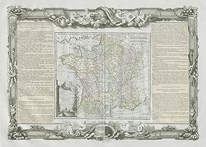
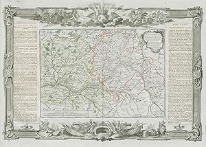
Condition: Good. "La France par Provinces Eccl�siastiques". DESNOS/DE LA TOUR 1771 old map. Antique eighteenth century copperplate atlas map with original hand colour, and ornate border. The flanking columns of descriptive text were stuck onto the sheet at the time of publication; Louis Brion de la Tour / Louis Desnos (1771). 56.5 x 44.0cm, 22.25 x 17.25 inches; this is a folding map. Condition: Good. There is nothing printed on the reverse side, which is plain. France, divided into Ecclestiastical provinces".
-
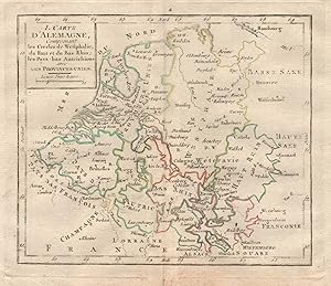
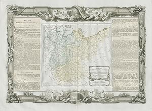
Condition: Good. "I. Carte d'Alemagne" by BRION DE LA TOUR. Benelux Westphalia Alsace 1777 map. Antique copperplate map with original outline colour; Grav�es par Andr� sur les dessins de Louis Brion de la Tour (1777). 18.5 x 16.5cm, 7.25 x 6.25 inches; this is a folding map. Condition: Good. There is nothing printed on the reverse side, which is plain.
-
III. Carte d'Alemagne, comprenant les Cercles de Bavi�re, d'Autriche et de Souabe avec La Suisee
Publication Date: 1777
Map
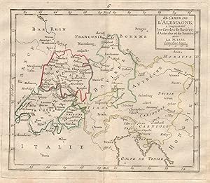
Condition: Good. "III. Carte d'Alemagne". BRION DE LA TOUR. Switzerland Austria Bavaria 1777 map. Antique copperplate map with original outline colour; Grav�es par Andr� sur les dessins de Louis Brion de la Tour (1777). 18.5 x 16.5cm, 7.25 x 6.25 inches; this is a folding map. Condition: Good. There is nothing printed on the reverse side, which is plain.
-
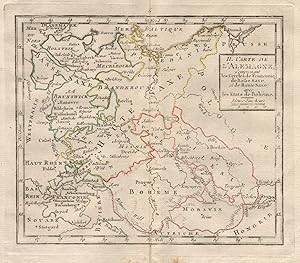
Condition: Good. "II. Carte d'Alemagne" by BRION DE LA TOUR. Germany Poland Czechia 1777 map. Antique copperplate map with original outline colour; Grav�es par Andr� sur les dessins de Louis Brion de la Tour (1777). 18.5 x 16.5cm, 7.25 x 6.25 inches; this is a folding map. Condition: Good. There is nothing printed on the reverse side, which is plain.
-
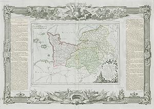
Condition: Good. "Gouvernemens de Normandie et du Havre". Normandy. DESNOS/DE LA TOUR 1771 map. Antique eighteenth century copperplate atlas map with original hand colour, and ornate border. The flanking columns of descriptive text were stuck onto the sheet at the time of publication; Louis Brion de la Tour / Louis Desnos (1771). 56.5 x 44.0cm, 22.25 x 17.25 inches; this is a folding map. Condition: Good. There is nothing printed on the reverse side, which is plain. Normandy including Le Havre, Rouen, Caen and Alen�on.
-
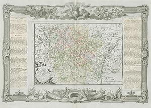
Condition: Good. "Les Duch�s de Lorraine, Bar Metz, Toul et Verdun". DESNOS/DE LA TOUR 1771 map. Antique eighteenth century copperplate atlas map with original hand colour, and ornate border. The flanking columns of descriptive text were stuck onto the sheet at the time of publication; Louis Brion de la Tour / Louis Desnos (1771). 56.5 x 44.0cm, 22.25 x 17.25 inches; this is a folding map. Condition: Good. Spot. There is nothing printed on the reverse side, which is plain. The Duchies of Lorraine, and of Bar, and the Bishoprics of Metz, Toul, and Verdun. Eastern France".
-
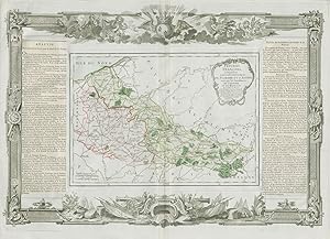
Condition: Good. "Pays-Bas Fran�ois, comprenant Flandre et d'Artois". DESNOS/DE LA TOUR 1771 map. Antique eighteenth century copperplate atlas map with original hand colour, and ornate border. The flanking columns of descriptive text were stuck onto the sheet at the time of publication; Louis Brion de la Tour / Louis Desnos (1771). 56.5 x 44.0cm, 22.25 x 17.25 inches; this is a folding map. Condition: Good. There is nothing printed on the reverse side, which is plain. The French low countries, comprising French Flanders (Nord) and Artois (Pas-de-Calais)".
-
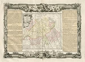
Condition: Good. "La Suisse". Switzerland. DESNOS/DE LA TOUR 1771 old antique map plan chart. Antique eighteenth century copperplate atlas map with original hand colour, and ornate border. The flanking columns of descriptive text were stuck onto the sheet at the time of publication; Louis Brion de la Tour / Louis Desnos (1771). 56.5 x 44.0cm, 22.25 x 17.25 inches; this is a folding map. Condition: Good. There is nothing printed on the reverse side, which is plain.
-
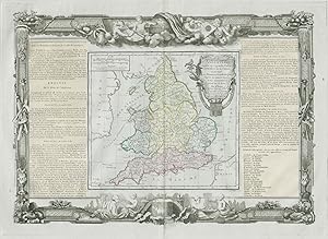
Condition: Good. "L'Angleterre divis�e en 5 grandes parties". England. DESNOS/DE LA TOUR 1771 map. Antique eighteenth century copperplate atlas map with original hand colour, and ornate border. The flanking columns of descriptive text were stuck onto the sheet at the time of publication; Louis Brion de la Tour / Louis Desnos (1771). 56.5 x 44.0cm, 22.25 x 17.25 inches; this is a folding map. Condition: Good. There is nothing printed on the reverse side, which is plain. England, unusually divided into 5 major parts.
-
Condition: Good. Cercles de Baviere, de Franconie et de Souabe Germany DESNOS/DE LA TOUR 1771 map. Antique eighteenth century copperplate atlas map with original hand colour, and ornate border. The flanking columns of descriptive text were stuck onto the sheet at the time of publication; Louis Brion de la Tour / Louis Desnos (1771). 56.5 x 44.0cm, 22.25 x 17.25 inches; this is a folding map. Condition: Good. There is nothing printed on the reverse side, which is plain. Circles of Bavaria, Franconia, and Swabia. Southern Germany.
-
Condition: Good. "Cercles de Westphalie, Haut et Bas Rhin". Germany. DESNOS/DE LA TOUR 1771 map. Antique eighteenth century copperplate atlas map with original hand colour, and ornate border. The flanking columns of descriptive text were stuck onto the sheet at the time of publication; Louis Brion de la Tour / Louis Desnos (1771). 56.5 x 44.0cm, 22.25 x 17.25 inches; this is a folding map. Condition: Good. There is nothing printed on the reverse side, which is plain. Westphalia, Upper and Lower Rhine. North West Germany. Hessen, Nordrhein-Westfalen, Bremen Niedersachsen & Rheinland-Pfalz.
-
Condition: Good. "Cercles de Haute et Basse Saxe" Lower & Upper Saxony DESNOS/DE LA TOUR 1771 map. Antique eighteenth century copperplate atlas map with original hand colour, and ornate border. The flanking columns of descriptive text were stuck onto the sheet at the time of publication; Louis Brion de la Tour / Louis Desnos (1771). 56.5 x 44.0cm, 22.25 x 17.25 inches; this is a folding map. Condition: Good. There is nothing printed on the reverse side, which is plain. Circles of Upper and Lower Saxony. North East Germany: Brandenburg, Sachsen-Anhalt, Thuringen, mecklenburg-Vorpommern, Holstein & Bremen-Niederscachsen.
-
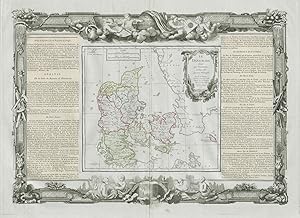
Condition: Good. "Le Danemark divis� par provinces ". Denmark. DESNOS/DE LA TOUR 1771 old map. Antique eighteenth century copperplate atlas map with original hand colour, and ornate border. The flanking columns of descriptive text were stuck onto the sheet at the time of publication; Louis Brion de la Tour / Louis Desnos (1771). 56.5 x 44.0cm, 22.25 x 17.25 inches; this is a folding map. Condition: Good. Blemish in margin. There is nothing printed on the reverse side, which is plain. Denmark divided by Provinces, and Dioceses".
-
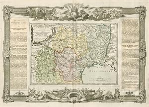
Condition: Good. "Gouvernemens de Languedoc de Roussillon " Occitanie. DESNOS/DE LA TOUR 1771 map. Antique eighteenth century copperplate atlas map with original hand colour, and ornate border. The flanking columns of descriptive text were stuck onto the sheet at the time of publication; Louis Brion de la Tour / Louis Desnos (1771). 56.5 x 44.0cm, 22.25 x 17.25 inches; this is a folding map. Condition: Good. There is nothing printed on the reverse side, which is plain. Languedoc, Roussillon, Foix, and part of Guienne and Gascogne. Toulouse, Montpellier, Montauban, Perpignan, and Auch. Occitanie".
-
Condition: Good. Poitou, Berri, Bourbonnois & Nivernois. Pays / Loire. DESNOS/DE LA TOUR 1771 map. Antique eighteenth century copperplate atlas map with original hand colour, and ornate border. The flanking columns of descriptive text were stuck onto the sheet at the time of publication; Louis Brion de la Tour / Louis Desnos (1771). 56.5 x 44.0cm, 22.25 x 17.25 inches; this is a folding map. Condition: Good. There is nothing printed on the reverse side, which is plain. Poitou, Berry, Bourbonnais, and Nivernais.
-
Condition: Good. "Gouvernemens de Bourgogne et de Franche-Comt�". DESNOS/DE LA TOUR 1771 map. Antique eighteenth century copperplate atlas map with original hand colour, and ornate border. The flanking columns of descriptive text were stuck onto the sheet at the time of publication; Louis Brion de la Tour / Louis Desnos (1771). 56.5 x 44.0cm, 22.25 x 17.25 inches; this is a folding map. Condition: Good. There is nothing printed on the reverse side, which is plain. Burgundy and Franche-Comt�".
-
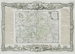
Condition: Good. Orl�anois, Touraine, Maine, Anjou & Saumurois. Loire. DESNOS/DE LA TOUR 1771 map. Antique eighteenth century copperplate atlas map with original hand colour, and ornate border. The flanking columns of descriptive text were stuck onto the sheet at the time of publication; Louis Brion de la Tour / Louis Desnos (1771). 56.5 x 44.0cm, 22.25 x 17.25 inches; this is a folding map. Condition: Good. There is nothing printed on the reverse side, which is plain. Loire Valley. Orleans, Touraine, Maine, Anjou, and Saumurois.
-
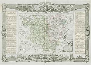
Voyage Dans Les D�partemens De La France : Enrichi de Tableaux G�ographiques et d'Estampes [23] [D�partement De La Haute-Marne]
Published by Paris Brion, 1793
First Edition
Couverture souple. Condition: Bon. Edition originale. In-8� broch�, exemplaire d�reli�, bien complet de la grande carte double page en couleurs, 31 pages.
-
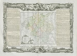
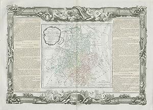
Condition: Good. "L'Alemagne divis�e en tous ses cercles". Germany. DESNOS/DE LA TOUR 1771 map. Antique eighteenth century copperplate atlas map with original hand colour, and ornate border. The flanking columns of descriptive text were stuck onto the sheet at the time of publication; Louis Brion de la Tour / Louis Desnos (1771). 56.5 x 44.0cm, 22.25 x 17.25 inches; this is a folding map. Condition: Good. Spot. There is nothing printed on the reverse side, which is plain. Germany divided into all its circles.
-
Condition: Good. "L'Isle de France et de Champagne". �le-de-France. DESNOS/DE LA TOUR 1771 map. Antique eighteenth century copperplate atlas map with original hand colour, and ornate border. The flanking columns of descriptive text were stuck onto the sheet at the time of publication; Louis Brion de la Tour / Louis Desnos (1771). 56.5 x 44.0cm, 22.25 x 17.25 inches; this is a folding map. Condition: Good. There is nothing printed on the reverse side, which is plain. The �le de France and Champagne, including Paris and Chalons.
-
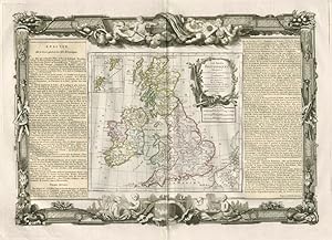
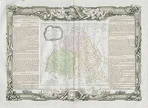
Condition: Good. "Les Isles Britanniques". British Isles. DESNOS/DE LA TOUR 1771 old map. Antique eighteenth century copperplate atlas map with original hand colour, and ornate border. The flanking columns of descriptive text were stuck onto the sheet at the time of publication; Louis Brion de la Tour / Louis Desnos (1771). 56.5 x 44.0cm, 22.25 x 17.25 inches; this is a folding map. Condition: Good. There is nothing printed on the reverse side, which is plain. The British Isles.
-
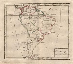
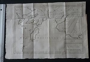
Condition: Good. "L'Am�rique M�ridionale" by BRION DE LA TOUR. South America 1777 old map. Antique copperplate map with original outline colour; Grav�es par Andr� sur les dessins de Louis Brion de la Tour (1777). 18.5 x 16.5cm, 7.25 x 6.25 inches; this is a folding map. Condition: Good. There is nothing printed on the reverse side, which is plain.
-
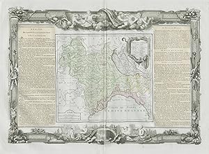
Condition: Good. "Partie de l'Italie " Milan Parme G�nes Italy Savoie. DESNOS/DE LA TOUR 1771 map. Antique eighteenth century copperplate atlas map with original hand colour, and ornate border. The flanking columns of descriptive text were stuck onto the sheet at the time of publication; Louis Brion de la Tour / Louis Desnos (1771). 56.5 x 44.0cm, 22.25 x 17.25 inches; this is a folding map. Condition: Good. There is nothing printed on the reverse side, which is plain. The continental part of the Kingdom of Sardinia, and the states of Milan, Parma, and Genoa. Present day north-western Italy, plus Savoie/Haute-Savoie and the Comt� de Nice. The map covers much of the present day French and Italian Alps".
![Seller image for Voyage Dans Les D�partemens De La France : Enrichi de Tableaux G�ographiques et d'Estampes [23] [D�partement De La Haute-Marne] for sale by PRISCA](https://pictures.abebooks.com/inventory/md/md31788049087.jpg)