Order Total (1 Item Items):
Shipping Destination:

Blaeu, Johan (53 results)
Skip to main search results
Product Type
- All Product Types
- Books (46)
- Magazines & Periodicals
- Comics
- Sheet Music
- Art, Prints & Posters (3)
- Photographs
- Maps (4)
-
Manuscripts &
Paper Collectibles
Condition
Binding
- All Bindings
- Hardcover (9)
- Softcover
Collectible Attributes
Free Shipping
Seller Location
Seller Rating
-

DUCATUS EBORACENSIS - Yorkshire - Reproduction of a Map Originally Drawn By Johan Blaeu in 1648
Published by John Bartholomew, Edinburgh, 1970
Seller: K Books Ltd ABA ILAB, York, YORKS, United Kingdom
Association Member: ABA ILAB PBFA
Seller Rating:

No Binding. Condition: Very Good. Blaeu (illustrator). Reproduction. A reproduction of a map by Johan Blaeu, drawn originally for his Atlas Novus of 1648; there is no date on this reproduction but it is c1970, on good quality paper. It was printed by John Bartholomew & Son of Edinburgh and published jointly with the Royal Scottish Geographical Society, in colour which is faithful to the contemporary colouring. The map shows the whole of Yorkshire, divided into Wapentakes, showing the churches and the parks of great houses. This map is too large to mount, so will be posted rolled in a tube.
-
![Seller image for Horti medici amstelodamensis rariorum tam Orientalis ?qua?m Occidentalis India, aliarumque peregrinarum plantarum, magno studio ac labore, sumptibus Civitatis amstelodamensis, longa? annorum serie collectarum, descriptio et icones ad vivum ari incisa /auctore Joanne Commelino. Opus posthumum, latinitate donatum, notisque & observationibus illustratum, a? Frederico Ruyschio & Francisco Kiggelario. Volume 2 [LeatherBound] for sale by True World of Books](https://pictures.abebooks.com/inventory/md/md31532895781.jpg)
Horti medici amstelodamensis rariorum tam Orientalis ?qua?m Occidentalis India, aliarumque peregrinarum plantarum, magno studio ac labore, sumptibus Civitatis amstelodamensis, longa? annorum serie collectarum, descriptio et icones ad vivum ari incisa /auctore Joanne Commelino. Opus posthumum, latinitate donatum, notisque & observationibus illustratum, a? Frederico Ruyschio & Francisco Kiggelario. Volume 2 [LeatherBound]
Publication Date: 2023
Book Print on Demand
LeatherBound. Condition: New. LeatherBound edition. Condition: New. Reprinted from 1697 edition. Leather Binding on Spine and Corners with Golden leaf printing on spine. Bound in genuine leather with Satin ribbon page markers and Spine with raised gilt bands. A perfect gift for your loved ones. NO changes have been made to the original text. This is NOT a retyped or an ocr'd reprint. Illustrations, Index, if any, are included in black and white. Each page is checked manually before printing. As this print on demand book is reprinted from a very old book, there could be some missing or flawed pages, but we always try to make the book as complete as possible. Fold-outs, if any, are not part of the book. If the original book was published in multiple volumes then this reprint is of only one volume, not the whole set. Sewing binding for longer life, where the book block is actually sewn (smythe sewn/section sewn) with thread before binding which results in a more durable type of binding. Pages: 328 Volume 2 Language: Latin.
-
![Seller image for Horti medici amstelodamensis rariorum tam Orientalis ?qua?m Occidentalis India, aliarumque peregrinarum plantarum, magno studio ac labore, sumptibus Civitatis amstelodamensis, longa? annorum serie collectarum, descriptio et icones ad vivum ari incisa /auctore Joanne Commelino. Opus posthumum, latinitate donatum, notisque & observationibus illustratum, a? Frederico Ruyschio & Francisco Kiggelario. Volume 1 [LeatherBound] for sale by True World of Books](https://pictures.abebooks.com/inventory/md/md31532894861.jpg)
Horti medici amstelodamensis rariorum tam Orientalis ?qua?m Occidentalis India, aliarumque peregrinarum plantarum, magno studio ac labore, sumptibus Civitatis amstelodamensis, longa? annorum serie collectarum, descriptio et icones ad vivum ari incisa /auctore Joanne Commelino. Opus posthumum, latinitate donatum, notisque & observationibus illustratum, a? Frederico Ruyschio & Francisco Kiggelario. Volume 1 [LeatherBound]
Publication Date: 2023
Book Print on Demand
LeatherBound. Condition: New. LeatherBound edition. Condition: New. Reprinted from 1697 edition. Leather Binding on Spine and Corners with Golden leaf printing on spine. Bound in genuine leather with Satin ribbon page markers and Spine with raised gilt bands. A perfect gift for your loved ones. NO changes have been made to the original text. This is NOT a retyped or an ocr'd reprint. Illustrations, Index, if any, are included in black and white. Each page is checked manually before printing. As this print on demand book is reprinted from a very old book, there could be some missing or flawed pages, but we always try to make the book as complete as possible. Fold-outs, if any, are not part of the book. If the original book was published in multiple volumes then this reprint is of only one volume, not the whole set. Sewing binding for longer life, where the book block is actually sewn (smythe sewn/section sewn) with thread before binding which results in a more durable type of binding. Pages: 344 Volume 1 Language: Latin.
-
Der Gro�e Atlas. Die Welt im 17. Jahrhundert. Einf�hrung, Texte und Auswahl der Karten von J. Goss. Vorwort von P. Clark.
Published by Wien P Neff ( ), 1990
ISBN 10: 370140304XISBN 13: 9783701403042
Book
Gr.4�. 224 S. Mit 100 farb. Karten. Original-Pappband mit Schutzumschlag. Schutzumschlag abgegriffen. Gewicht (Gramm): 2800.
-
PRAEFECTURA RENFROANA VULGO DICTA BARONIA - the Baronie of Renfrow - MAP OF PART OF RENFREWSHIRE, SCOTLAND - Reproduction of a Map Originally Drawn By Johan Blaeu in 1654
Published by John Bartholomew, Edinburgh, 1970
Seller: K Books Ltd ABA ILAB, York, YORKS, United Kingdom
Association Member: ABA ILAB PBFA
Seller Rating:
Book
No Binding. Condition: Very Good. Blaeu (illustrator). Reproduction. A reproduction of a map by Johan Blaeu, drawn originally for his Atlas Novus of 1654, reprinted in 1662; there is no date on this reproduction but it is c1970, on good quality paper. It was printed by John Bartholomew & Son of Edinburgh and published jointly with the Royal Scottish Geographical Society, in colour which is faithful to the contemporary colouring. The map shows the Firth of Clyde as far as Glasgow, in detail as far west as Gourock with an indication of the port of Largs, as far sough as the Loch of Kilbirnie. This map is too large to mount, so will be posted rolled in a tube.
-
MULA INSULA - the Yle of Mul - THE ISLAND OF MULL, SCOTLAND - Reproduction of a Map Originally Drawn By Johan Blaeu in 1654
Published by John Bartholomew, Edinburgh, 1970
Seller: K Books Ltd ABA ILAB, York, YORKS, United Kingdom
Association Member: ABA ILAB PBFA
Seller Rating:
Book
No Binding. Condition: Very Good. Blaeu (illustrator). Reproduction. A reproduction of a map by Johan Blaeu, drawn originally for his Atlas Novus of 1654, reprinted in 1662; there is no date on this reproduction but it is c1970, on good quality paper. It was printed by John Bartholomew & Son of Edinburgh and published jointly with the Royal Scottish Geographical Society, in colour which is faithful to the contemporary colouring. The map shows the Island of Mull including Iona, Tiree, Coll, Lismore & part of Jura. This map is too large to mount, so will be posted rolled in a tube.
-
CHESHIRE - Colour Reproduction of a Map Originally Drawn By Johan Blaeu in 1648
Published by John Bartholomew, Edinburgh, 1970
Seller: K Books Ltd ABA ILAB, York, YORKS, United Kingdom
Association Member: ABA ILAB PBFA
Seller Rating:
Book
No Binding. Condition: Very Good. Blaeu (illustrator). Reproduction. A reproduction of a map by Johan Blaeu, drawn originally for his Atlas Novus of 1648 reprinted in 1662; there is no date on this reproduction but it is c1970, on good quality paper. It was printed by John Bartholomew & Son of Edinburgh and published jointly with the Royal Scottish Geographical Society, in colour which is faithful to the contemporary colouring. The title of the map is "Cestria Comitatus Palatinus" and it is ornamented with coats of arms. This map is too large to post mounted and so will be posted rolled in a tube.
-
Middle-Sexia Map (Atlas Novus, 1648) | Middlesex.
Published by Published Jointly with the Royal Geographical Society | Printed by John Bartholomew & Son Ltd., Edinburgh.
Seller: Little Stour Books PBFA Member, Canterbury, United Kingdom
Association Member: PBFA
Seller Rating:
Coloured facsimile reprint of the original authentic map of Middlesex. 19�'' x 24''. In Fine condition. Sent rolled in a tube. Member of the P.B.F.A. MIDDLESEX (Middleseaxan).
-

Hertfordia Comitatvs Vernacule | Hertfordshire Map (Atlas Novus, 1648).
Published by Published Jointly with the Royal Geographical Society | Printed by John Bartholomew & Son Ltd., Edinburgh.
Seller: Little Stour Books PBFA Member, Canterbury, United Kingdom
Association Member: PBFA
Seller Rating:
Coloured facsimile reprint of the original authentic map of Hertfordshire. 19�'' x 24''. In Fine condition. Sent rolled in a tube. Member of the P.B.F.A. HERTFORDSHIRE.
-
Magnae Britanniae et Hiberniae Tabula (Great Britain and Ireland Map) Theatrum Orbis Terrarum, 1635.
Published by Published Jointly with the Royal Geographical Society | Printed by John Bartholomew & Son Ltd., Edinburgh.
Seller: Little Stour Books PBFA Member, Canterbury, United Kingdom
Association Member: PBFA
Seller Rating:
Coloured facsimile reprint of the original authentic map of Great Britain and Ireland on fine quality water-marked cream paper. 20'' x 24''. In Very Good condition with some crease lines along the bottom edge. Sent rolled in a tube. Member of the P.B.F.A. CARTOGRAPHY, MAPS, PLANS.
-
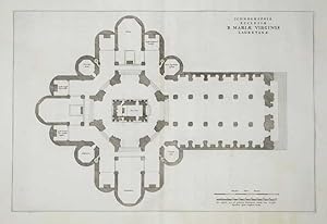
Ichnographia Ecclesiae B. Mariae Virginis Lauretanae
Published by Loreto
Seller: Sergio Trippini, Gavirate, Italy
Seller Rating:
Pianta della chiesa, dedicata alla Vergine Maria.
-
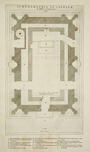
Ichnographia S.S. Capellae
Published by Loreto
Seller: Sergio Trippini, Gavirate, Italy
Seller Rating:
-
Cascata del Teverone a Tivoli
Published by Tivoli
Seller: Sergio Trippini, Gavirate, Italy
Seller Rating:
Veduta panoramica con le grandi cascate, molto decorativa.
-
Pianta planimetrica prospettica della citt�.
-
Veduta della citt� lungo il fiume Tevere, percorso da imbarcazioni. Testo al Verso.
-
Atlas Maior. Le Grand Atlas Volume V. Facsimile; Le Grand Atlas ou Cosmographie Blaviane Vol. V. The Third Centenary Edition. Facsimile of the 1663 Amsterdam Edition
Published by Theatrum Orbis Terrarum Ltd, Amsterdam, 1967
Book
Hardcover. Condition: Near Fine. Dust Jacket Condition: No DJ. Published: 1967. Facsimile Reprint. Limited edition. Limited edition of 1,000 copies. This volume is not numbered. DESCRIPTION: Single volume (Vol V) from the 12 volume facsimile edition of the first French edition of Blaeu's Atlas Major commissioned for the 300th anniversary of its original publication. Bound in imitation white, vellum-colored cloth, decorated in gilt. Blue morocco gilt spine labels. Language: English. Book Condition: Near Fine: Minor chip to rear board edge. Lightly creased spine ends. Minor marks to lightly rubbed boards. Tightly bound with clean intact endpapers and strong hinges. Clean unmarked pages. DJ Condition: No DJ Pages 325. Size: 55cm by 33cm. POSTAGE: PLEASE NOTE - This is a heavy item and may require additional postage for overseas deliveries. We will contact you if additional charges are required. Please see our postage policy on our shop front for more information.
-
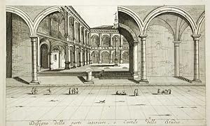
Dissegno della parte interiore, o Cortile dello Studio
Published by Bologna
Seller: Sergio Trippini, Gavirate, Italy
Seller Rating:
Vedute dei portici dello studio publico.
-
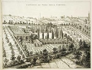
Convento de' Padri della Certosa
Published by Bologna
Seller: Sergio Trippini, Gavirate, Italy
Seller Rating:
Veduta del convento della Certosa.
-
![Seller image for Iutia olim Cimbrica Chersonesus [J�tland, einst Cimbrica Chersonesus]. Kolorierte Kupferstichkarte mit 2 fig�rlichen Kartuschen. for sale by Antiquariat Reinhold Pabel](https://pictures.abebooks.com/inventory/md/md20854201854.jpg)
Iutia olim Cimbrica Chersonesus [J�tland, einst Cimbrica Chersonesus]. Kolorierte Kupferstichkarte mit 2 fig�rlichen Kartuschen.
Published by [Amsterdam, Johannes Blaeu, [ca. ], 1667
Map
[Amsterdam, Johannes Blaeu, [ca. 1667]. Darstellung ca. 43,5 x 57,5 cm., Blatt ca. 52 x 61 cm. J�tlandkarte mit Aalborg, Aarhus, T�nder (Tondern), Wiborg (Viborg), geostete. Johan Blaeu (1596-1673) f�hrte mit seinem Bruder Cornelis die vom Vater Willem Janszoon Blaeu gegr�ndete kartographische Anstalt weiter. - Vgl. National Library of Scotland, Maps Collection, Sign. EMW.X.017. - Erwas gebr�unt, im Bugfalz heller, gebrochen und unterlegt. Blattr�nder r�ckseitig mit Papierstreifen verst�rkt.
-
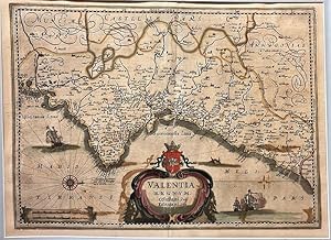
(Amsterdam, hacia 1640), mapa original en plancha de cobre del Reino de Valencia, en colores de �poca, 35 x 47,5 cm. (Texto en lat�n a la vuelta, con algunas leves restauraciones). VALENCIA.
-

Andaluzia continens Sevillam et Cordubam.
Seller: Librer�a Anticuaria Antonio Mateos, Malaga, Spain
Seller Rating:
(�msterdam, hacia 1650), mapa original en plancha coloreada de �poca, de 38 x 49,5 cm. (Texto latino a la vuelta).
-
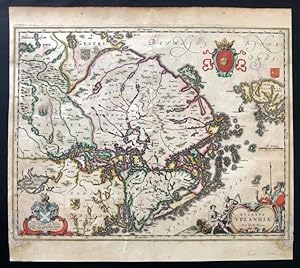
Ducatus Uplandia.
Publication Date: 1640
Seller: BOTTEGHINA D'ARTE GALLERIA K�PROS, Rosignano Solvay, LI, Italy
Seller Rating:

Art / Print / Poster
No legatura. Condition: discreto. Amsterdam, 1640 circa. Tratta dal "Theatrum Orbis Terrarum", incisione in rame all'acquaforte, colore d'epoca, cm 39 x 50 (alla lastra) pi� margini, testo francese al verso. Tracce di muffa in corrispondenza degli angoli inferiori, qualche arrossamento nella parte superiore ma nell'insieme discreto stato. 250.
-
Le Grand Atlas [ Facsimile Volume 5 ]
Published by Theatrum Orbis Terrarum Ltd, Amsterdam, 1967
First Edition
Vellum. Condition: Very Good. Limited Edition. Volume 5 of a 12 volume set. Limited to 1000 copies. Book measures 55x34.cm. 321pp, double page maps throughout. Bound in original publishers faux vellum, ornate gilt tooling. Vellum bumped, some dust,dirt marking. Generally binding in good clean firm condition. Internally, pages clean throughout. A good solid copy. Size: Filio.
-
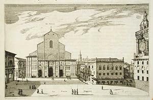
Veduta della chiesa di San Petronio e piazza Maggiore.
-
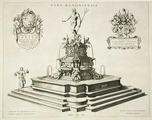
Statua del Nettuno.
-
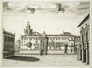
Veduta della Piazza maggiore con il Palazzo del Podest� in Faccia
Published by Bologna
Seller: Sergio Trippini, Gavirate, Italy
Seller Rating:
Veduta di Piazza Maggiore.
-
Veduta della Piazza Maggiore con il Palazzo maggiore in faccia
Published by Bologna
Seller: Sergio Trippini, Gavirate, Italy
Seller Rating:
Veduta di Piazza Maggiore.
-
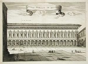
Studio Publico in Bologna
Published by Bologna
Seller: Sergio Trippini, Gavirate, Italy
Seller Rating:
Veduta dello Publico in Bologna e piazza antistante.
-
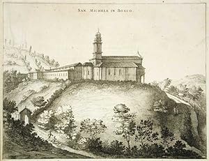
Veduta dell chiesa di San Michele in Bosco.
-
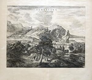
Terracina ou Terracine, Ville de l Etat de L Eglise.
Publication Date: 1724
Seller: BOTTEGHINA D'ARTE GALLERIA K�PROS, Rosignano Solvay, LI, Italy
Seller Rating:
Art / Print / Poster
No legatura. Condition: ottimo. Pierre Mortier, Amsterdam, 1724 circa. Incisione in rame all acquaforte, b/n, cm 40 x 51 circa (alla lastra) pi� ampi margini, in bs. a ds. il monogramma LV. Questa stampa, insieme ad altre citt� italiane, comparve per la prima volta nel "Theatrum Civitatum et admirandorum Italiae", pubblicato ad Amsterdam nel 1663. Veduta della citt� di Terracina e dintorni. Ottimo lo stato di conservazione. .


![Seller image for Le Grand Atlas [ Facsimile Volume 5 ] for sale by George Jeffery Books](https://pictures.abebooks.com/inventory/md/md31691678917.jpg)