
Order Total (1 Item Items):
Shipping Destination:

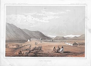
Pacific Railroad Survey , (77 results)
Skip to main search results
Product Type
- All Product Types
- Books (18)
- Magazines & Periodicals
- Comics
- Sheet Music
- Art, Prints & Posters (57)
- Photographs
- Maps (2)
-
Manuscripts &
Paper Collectibles
Condition
Binding
Collectible Attributes
- First Edition (2)
- Signed
- Dust Jacket
- Seller-Supplied Images (72)
- Not Printed On Demand (75)
Free Shipping
Seller Location
Seller Rating
-
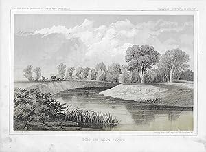
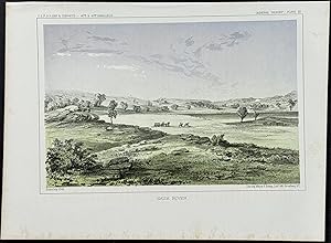
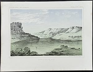
BOIS DE SIOUX RIVER: PLATE VII - Pacific Railroad Survey Lithograph
Published by Washington, DC, 1861
Book
print. Condition: Very Good with Wear. John Mix Stanley (illustrator). DESCRIPTION: Here is a lithographic View of BOIS DE SIOUX RIVER: PLATE VII - Pacific Railroad Survey Lithograph by Sarony, Major & Knapp. * This tinted Pacific Railroad Expedition and Survey original view is from the time period of 1855 through 1861. * The plates are from United States Pacific Railroad Expedition and Surveys (USPRR) between the 47th and 49th Parallels. * These views from the Pacific Railroad surveys were printed with 2 or 3 colors and most have a small pinhole at center of the lower border for registration of the colors. Printed in browns and grey tones. * This lithographic image will measure about 6 inches by 9 inches on a sheet that is about 7 1/4 by 10 inches. CONDITION: There is some foxing.
-

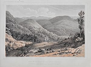
PROFILE OF WALKERS PASS, HUM-PAH-YA-MUP PASS, TAH-EE-CHAY-PAH PASS, ROUTE FROM SUMMIT OF TAH-EE-CHAY-PAH PASS TO THE TEJON DEPOT CAMP, PROFILE OF NEW PASS, SAN FERNANDO PASS [1853-1855]
Published by Pacific Railroad Survey Map, 1853
Pamphlet. Condition: Very Good. (6 profiles on sheet), Hor. scale 1/120,000; Vert. scale 1/24,000, 20 x 30 inches, folded, VG (Wagner-Camp number 261:4 No 13).
-
Teton Valley Lithograph General Report of the USPRR Expedition & Surveys 47th and 49th Parallel. Plate XXVIII circa 1855.
Published by USPRR Expedition & Survey, New York, 1855
Plate Planche. Coloured lithographic plate measuring 28cm/11 inches by 22cm/8.5 inches. Please Feel free to inquire as to particulars and/or additional snapshots.
-
![Seller image for The natural history of Washington territory and Oregon : with much relating to Minnesota, Nebraska, Kansas, Utah, and California between the thirty-sixth and forty-ninth parallels of latitude : being those parts of the final reports on the survey of the Northern Pacific Railroad route, relating to the natural history of the regions explored : with full catalogues and descriptions of the plants and animals collected from 1853 to 1860 [LeatherBound] for sale by True World of Books](https://pictures.abebooks.com/inventory/md/md31533923978.jpg)
The natural history of Washington territory and Oregon : with much relating to Minnesota, Nebraska, Kansas, Utah, and California between the thirty-sixth and forty-ninth parallels of latitude : being those parts of the final reports on the survey of the Northern Pacific Railroad route, relating to the natural history of the regions explored : with full catalogues and descriptions of the plants and animals collected from 1853 to 1860 [LeatherBound]
Publication Date: 2023
Book Print on Demand
LeatherBound. Condition: New. LeatherBound edition. Condition: New. Reprinted from 1860 edition. Leather Binding on Spine and Corners with Golden leaf printing on spine. Bound in genuine leather with Satin ribbon page markers and Spine with raised gilt bands. A perfect gift for your loved ones. NO changes have been made to the original text. This is NOT a retyped or an ocr'd reprint. Illustrations, Index, if any, are included in black and white. Each page is checked manually before printing. As this print on demand book is reprinted from a very old book, there could be some missing or flawed pages, but we always try to make the book as complete as possible. Fold-outs, if any, are not part of the book. If the original book was published in multiple volumes then this reprint is of only one volume, not the whole set. Sewing binding for longer life, where the book block is actually sewn (smythe sewn/section sewn) with thread before binding which results in a more durable type of binding. Pages: 644 Language: English.
-
![Seller image for The natural history of Washington territory, with much relating to Minnesota, Nebraska, Kansas, Oregon, and California, between the thirty-sixth and forty-ninth parallels of latitude, being those parts of the final reports on the survey of the Northern Pacific railroad route, containing the climate and physical geography, with full catalogues and descriptions of the plants and animals collected from 1853 to 1857 [LeatherBound] for sale by True World of Books](https://pictures.abebooks.com/inventory/md/md31533918432.jpg)
The natural history of Washington territory, with much relating to Minnesota, Nebraska, Kansas, Oregon, and California, between the thirty-sixth and forty-ninth parallels of latitude, being those parts of the final reports on the survey of the Northern Pacific railroad route, containing the climate and physical geography, with full catalogues and descriptions of the plants and animals collected from 1853 to 1857 [LeatherBound]
Publication Date: 2023
Book Print on Demand
LeatherBound. Condition: New. LeatherBound edition. Condition: New. Reprinted from 1859 edition. Leather Binding on Spine and Corners with Golden leaf printing on spine. Bound in genuine leather with Satin ribbon page markers and Spine with raised gilt bands. A perfect gift for your loved ones. NO changes have been made to the original text. This is NOT a retyped or an ocr'd reprint. Illustrations, Index, if any, are included in black and white. Each page is checked manually before printing. As this print on demand book is reprinted from a very old book, there could be some missing or flawed pages, but we always try to make the book as complete as possible. Fold-outs, if any, are not part of the book. If the original book was published in multiple volumes then this reprint is of only one volume, not the whole set. Sewing binding for longer life, where the book block is actually sewn (smythe sewn/section sewn) with thread before binding which results in a more durable type of binding. Pages: 684 Language: English.
-
SUMMIT OF THE NEAREST RIDGES SOUTH OF GRAND RIVER - Traversed in passing around lateral CANonrs 12 O'clock, Sept.12. - Pacific Railroad Survey Lithograph
Published by Washington, DC, 1861
Book
print. Condition: Very Good with Wear. John Mix Stanley (illustrator). DESCRIPTION: Here is a lithographic View of SUMMIT OF THE NEAREST RIDGES SOUTH OF GRAND RIVER - Traversed in passing around lateral CANonrs 12 O'clock, Sept.12. - Pacific Railroad Survey Lithograph - Pacific Railroad Survey Lithograph by Sarony, Major & Knapp. * This tinted Pacific Railroad Expedition and Survey original view is from the time period of 1855 through 1861. * The plates are from United States Pacific Railroad Expedition and Surveys (USPRR) between the 47th and 49th Parallels. * These views from the Pacific Railroad surveys were printed with 2 or 3 colors and most have a small pinhole at center of the lower border for registration of the colors. Printed in browns and grey tones. * This lithographic image will measure about 6 inches by 9 inches on a sheet that is about 7 1/4 by 10 inches. CONDITION: There is some foxing.
-
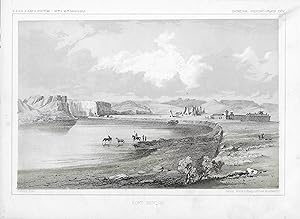
FORT BENTON - General Report Plate # XXIV - Pacific Railroad Survey Lithograph
Published by Washington, DC, 1861
Book
print. Condition: Very Good with Wear. John Mix Stanley (illustrator). DESCRIPTION: Here is a lithographic View of FORT BENTON - General Report Plate # XXIV - Pacific Railroad Survey Lithograph by Sarony, Major & Knapp. * This tinted Pacific Railroad Expedition and Survey original view is from the time period of 1855 through 1861. * The plates are from United States Pacific Railroad Expedition and Surveys (USPRR) between the 47th and 49th Parallels. * These views from the Pacific Railroad surveys were printed with 2 or 3 colors and most have a small pinhole at center of the lower border for registration of the colors. Printed in browns and grey tones. * This lithographic image will measure about 6 inches by 9 inches on a sheet that is about 7 1/4 by 10 inches. CONDITION: There is some foxing.
-
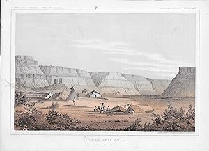
OLD FORT WALA WALA - General Report Plate # XLII - Pacific Railroad Survey Lithograph
Published by Washington, DC, 1861
Book
print. Condition: Very Good with Wear. John Mix Stanley (illustrator). DESCRIPTION: Here is a lithographic View of OLD FORT WALA WALA - General Report Plate # XLII - Pacific Railroad Survey Lithograph by Sarony, Major & Knapp. * This tinted Pacific Railroad Expedition and Survey original view is from the time period of 1855 through 1861. * The plates are from United States Pacific Railroad Expedition and Surveys (USPRR) between the 47th and 49th Parallels. * These views from the Pacific Railroad surveys were printed with 2 or 3 colors and most have a small pinhole at center of the lower border for registration of the colors. Printed in browns and grey tones. * This lithographic image will measure about 6 inches by 9 inches on a sheet that is about 7 1/4 by 10 inches. CONDITION: There is some foxing.
-
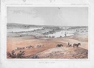
WHITE BEAR LAKE - General Report Plate # V - Pacific Railroad Survey Lithograph
Published by Washington, DC, 1861
Book
print. Condition: Very Good with Wear. John Mix Stanley (illustrator). DESCRIPTION: Here is a lithographic View of WHITE BEAR LAKE - General Report Plate # V - Pacific Railroad Survey Lithograph by Sarony, Major & Knapp. * This tinted Pacific Railroad Expedition and Survey original view is from the time period of 1855 through 1861. * The plates are from United States Pacific Railroad Expedition and Surveys (USPRR) between the 47th and 49th Parallels. * These views from the Pacific Railroad surveys were printed with 2 or 3 colors and most have a small pinhole at center of the lower border for registration of the colors. Printed in browns and grey tones. * This lithographic image will measure about 6 inches by 9 inches on a sheet that is about 7 1/4 by 10 inches. CONDITION: There is some foxing.
-
FORT OKINAKANE: General Report - Plate XXXVII - Pacific Railroad Survey Lithograph
Published by Washington, DC, 1861
Book
print. Condition: Very Good with Wear. John Mix Stanley (illustrator). DESCRIPTION: Here is a lithographic View of FORT OKINAKANE: General Report - Plate XXXVII - Pacific Railroad Survey Lithograph by Sarony, Major & Knapp. * This tinted Pacific Railroad Expedition and Survey original view is from the time period of 1855 through 1861. * The plates are from United States Pacific Railroad Expedition and Surveys (USPRR) between the 47th and 49th Parallels. * These views from the Pacific Railroad surveys were printed with 2 or 3 colors and most have a small pinhole at center of the lower border for registration of the colors. Printed in browns and grey tones. * This lithographic image will measure about 6 inches by 9 inches on a sheet that is about 7 1/4 by 10 inches. CONDITION: There is some foxing.
-
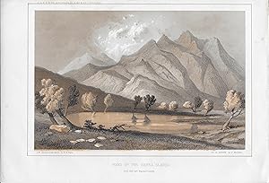
PEAKS OF THE SIERRA BLANCA: From Near Fort Massachusetts - Pacific Railroad Survey Lithograph
Published by Washington, DC, 1861
Book
print. Condition: Very Good with Wear. John Mix Stanley From Sketch by R. H. Kern (illustrator). DESCRIPTION: Here is a lithographic View of PEAKS OF THE SIERRA BLANCA: From NearFort Massachusetts - Pacific Railroad Survey Lithograph by Sarony, Major & Knapp. * This tinted Pacific Railroad Expedition and Survey original view is from the time period of 1855 through 1861. * The plates are from United States Pacific Railroad Expedition and Surveys (USPRR) between the 47th and 49th Parallels. * These views from the Pacific Railroad surveys were printed with 2 or 3 colors and most have a small pinhole at center of the lower border for registration of the colors. Printed in browns and grey tones. * This lithographic image will measure about 6 inches by 9 inches on a sheet that is about 7 1/4 by 10 inches. CONDITION: There is some foxing.
-
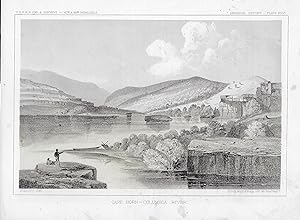
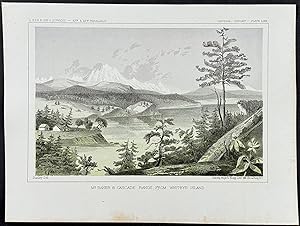
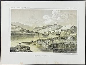
Cape Horn: General Report Plate # XLVI - Pacific Railroad Survey Lithograph
Published by Government Printing Office, Washington, D.C., 1861
Book
print. Condition: Very Good with Wear. John Mix Stanley (illustrator). DESCRIPTION: Here is a lithographic View of Cape Horn: General Report Plate # XLVI- Pacific Railroad Survey Lithograph by Sarony, Major & Knapp. * This tinted Pacific Railroad Expedition and Survey original view is from the time period of 1855 through 1861. * The plates are from United States Pacific Railroad Expedition and Surveys (USPRR) between the 47th and 49th Parallels. * These views from the Pacific Railroad surveys were printed with 2 or 3 colors and most have a small pinhole at center of the lower border for registration of the colors. Printed in browns and grey tones. * This lithographic image will measure about 6 inches by 9 inches on a sheet that is about 7 1/4 by 10 inches. CONDITION: There is some foxing.
-
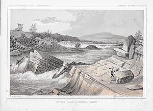
Kettle Falls, Columbia River: General Report Plate # XLVII - Pacific Railroad Survey Lithograph
Published by Government Printing Office, Washington, D.C., 1861
Book
print. Condition: Very Good with Wear. John Mix Stanley (illustrator). DESCRIPTION: Here is a lithographic View of Kettle Falls, Columbia River: General Report Plate # XLVII - Pacific Railroad Survey Lithograph by Sarony, Major & Knapp. * This tinted Pacific Railroad Expedition and Survey original view is from the time period of 1855 through 1861. * The plates are from United States Pacific Railroad Expedition and Surveys (USPRR) between the 47th and 49th Parallels. * These views from the Pacific Railroad surveys were printed with 2 or 3 colors and most have a small pinhole at center of the lower border for registration of the colors. Printed in browns and grey tones. * This lithographic image will measure about 6 inches by 9 inches on a sheet that is about 7 1/4 by 10 inches. CONDITION: There is some foxing.
-
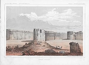
GRAND COULEE: General Report Plate #XLVIII - Pacific Railroad Survey Lithograph
Published by Government Printing Office, Washington, D.C., 1861
Book
print. Condition: Very Good with Wear. John Mix Stanley (illustrator). DESCRIPTION: Here is a lithographic View of GRAND COULEE: General Report Plate #XLVIII - Pacific Railroad Survey Lithograph by Sarony, Major & Knapp. * This tinted Pacific Railroad Expedition and Survey original view is from the time period of 1855 through 1861. * The plates are from United States Pacific Railroad Expedition and Surveys (USPRR) between the 47th and 49th Parallels. * These views from the Pacific Railroad surveys were printed with 2 or 3 colors and most have a small pinhole at center of the lower border for registration of the colors. Printed in browns and grey tones. * This lithographic image will measure about 6 inches by 9 inches on a sheet that is about 7 1/4 by 10 inches. CONDITION: There is some foxing.
-
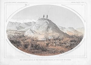
HOT SPRING MOUND IN THE " DEER LODGE" PRAIRIE OF THE ROCKY MOUNTAINS: PLATE L - Pacific Railroad Survey Lithograph
Published by Washington, DC, 1861
Book
print. Condition: Very Good with Wear. John Mix Stanley (illustrator). DESCRIPTION: Here is a lithographic View of HOT SPRING MOUND IN THE " DEER LODGE" PRAIRIE OF THE ROCKY MOUNTAINS: PLATE L - Pacific Railroad Survey Lithograph by Sarony, Major & Knapp. * This tinted Pacific Railroad Expedition and Survey original view is from the time period of 1855 through 1861. * The plates are from United States Pacific Railroad Expedition and Surveys (USPRR) between the 47th and 49th Parallels. * These views from the Pacific Railroad surveys were printed with 2 or 3 colors and most have a small pinhole at center of the lower border for registration of the colors. Printed in browns and grey tones. * This lithographic image will measure about 6 inches by 9 inches on a sheet that is about 7 1/4 by 10 inches. CONDITION: There is some foxing.
-
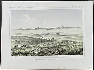
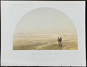
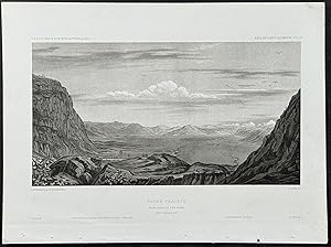
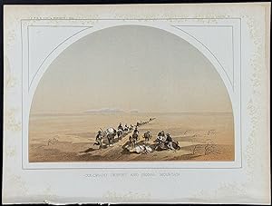
Condition: Fine. This historic lithograph is from Reports of Explorations and Surveys, to Ascertain the Most Practicable and Economical Route for a Railroad from the Mississippi River to the Pacific Ocean. The work was published between 1855 and 1860 in Washington by Beverley Tucker, Thomas F. Ford, and A.O.P. Nicholson.The work came about as part of the Pacific Railroad Surveys conducted under the direction of the Secretary of War, Jefferson Davis. The Surveys were conducted to explore the American West and document possible routes for trancontinental North American railroads. Surveyors, scientists, and artist partook in the journeys and gathered information that covered 400,000 square miles.The publication was ". probably the most important single contemporary source of knowledge on Western geography and history and their value is greatly enhanced by the inclusion of many beautiful plates in color of scenery, native inhabitants, fauna and flora of the Western country." (Robert Taft, Artists and Illustrators of the Old West, p. 5)The Reports ". contain[ed] a monumental collection of scientific information, geographical, zoological, botanical, geological of the still mysterious American West. Upon first examination, the volumes seem forbiddingly disorganized, however these faults are amply compensated by the richness of material within." (Wagner-Camp 262) --- The work is in very good to excellent condition overall. There may be a few minor imperfections to be expected with age. Please review the image carefully for condition and contact us with any questions. --- Paper Size ~ 11 1/2" by 8 5/8".
-
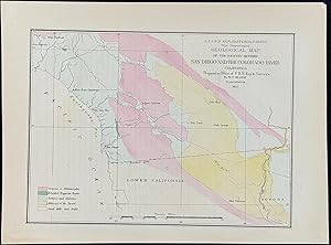
Geological Map of the Country Between San Diego & the colorado River, California
Published by Washington, 1855
Art / Print / Poster
Condition: Fine. This historic lithograph is from Reports of Explorations and Surveys, to Ascertain the Most Practicable and Economical Route for a Railroad from the Mississippi River to the Pacific Ocean. The work was published between 1855 and 1860 in Washington by Beverley Tucker, Thomas F. Ford, and A.O.P. Nicholson.The work came about as part of the Pacific Railroad Surveys conducted under the direction of the Secretary of War, Jefferson Davis. The Surveys were conducted to explore the American West and document possible routes for trancontinental North American railroads. Surveyors, scientists, and artist partook in the journeys and gathered information that covered 400,000 square miles.The publication was ". probably the most important single contemporary source of knowledge on Western geography and history and their value is greatly enhanced by the inclusion of many beautiful plates in color of scenery, native inhabitants, fauna and flora of the Western country." (Robert Taft, Artists and Illustrators of the Old West, p. 5)The Reports ". contain[ed] a monumental collection of scientific information, geographical, zoological, botanical, geological of the still mysterious American West. Upon first examination, the volumes seem forbiddingly disorganized, however these faults are amply compensated by the richness of material within." (Wagner-Camp 262) --- The work is in very good to excellent condition overall. There may be a few minor imperfections to be expected with age. Please review the image carefully for condition and contact us with any questions. --- Paper Size ~ 11 1/2" by 8 5/8".
-
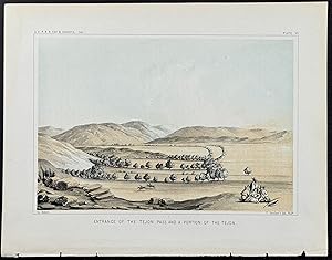
Entrance of the Tejon Pass and a Portion of the Tejon
Published by Washington, 1855
Art / Print / Poster
Condition: Fine. This historic lithograph is from Reports of Explorations and Surveys, to Ascertain the Most Practicable and Economical Route for a Railroad from the Mississippi River to the Pacific Ocean. The work was published between 1855 and 1860 in Washington by Beverley Tucker, Thomas F. Ford, and A.O.P. Nicholson.The work came about as part of the Pacific Railroad Surveys conducted under the direction of the Secretary of War, Jefferson Davis. The Surveys were conducted to explore the American West and document possible routes for trancontinental North American railroads. Surveyors, scientists, and artist partook in the journeys and gathered information that covered 400,000 square miles.The publication was ". probably the most important single contemporary source of knowledge on Western geography and history and their value is greatly enhanced by the inclusion of many beautiful plates in color of scenery, native inhabitants, fauna and flora of the Western country." (Robert Taft, Artists and Illustrators of the Old West, p. 5)The Reports ". contain[ed] a monumental collection of scientific information, geographical, zoological, botanical, geological of the still mysterious American West. Upon first examination, the volumes seem forbiddingly disorganized, however these faults are amply compensated by the richness of material within." (Wagner-Camp 262) --- The work is in very good to excellent condition overall. There may be a few minor imperfections to be expected with age. Please review the image carefully for condition and contact us with any questions. --- Paper Size ~ 11 1/2" by 8 5/8".
-
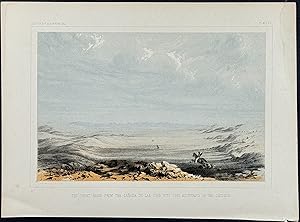
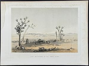
The Great Basin from the Canada de las Uvas with Lost Mountains in the Distance
Published by Washington, 1855
Art / Print / Poster
Condition: Fine. This historic lithograph is from Reports of Explorations and Surveys, to Ascertain the Most Practicable and Economical Route for a Railroad from the Mississippi River to the Pacific Ocean. The work was published between 1855 and 1860 in Washington by Beverley Tucker, Thomas F. Ford, and A.O.P. Nicholson.The work came about as part of the Pacific Railroad Surveys conducted under the direction of the Secretary of War, Jefferson Davis. The Surveys were conducted to explore the American West and document possible routes for trancontinental North American railroads. Surveyors, scientists, and artist partook in the journeys and gathered information that covered 400,000 square miles.The publication was ". probably the most important single contemporary source of knowledge on Western geography and history and their value is greatly enhanced by the inclusion of many beautiful plates in color of scenery, native inhabitants, fauna and flora of the Western country." (Robert Taft, Artists and Illustrators of the Old West, p. 5)The Reports ". contain[ed] a monumental collection of scientific information, geographical, zoological, botanical, geological of the still mysterious American West. Upon first examination, the volumes seem forbiddingly disorganized, however these faults are amply compensated by the richness of material within." (Wagner-Camp 262) --- The work is in very good to excellent condition overall. There may be a few minor imperfections to be expected with age. Please review the image carefully for condition and contact us with any questions. --- Paper Size ~ 11 1/2" by 8 5/8".
-
Condition: Fine. This historic lithograph is from Reports of Explorations and Surveys, to Ascertain the Most Practicable and Economical Route for a Railroad from the Mississippi River to the Pacific Ocean. The work was published between 1855 and 1860 in Washington by Beverley Tucker, Thomas F. Ford, and A.O.P. Nicholson.The work came about as part of the Pacific Railroad Surveys conducted under the direction of the Secretary of War, Jefferson Davis. The Surveys were conducted to explore the American West and document possible routes for trancontinental North American railroads. Surveyors, scientists, and artist partook in the journeys and gathered information that covered 400,000 square miles.The publication was ". probably the most important single contemporary source of knowledge on Western geography and history and their value is greatly enhanced by the inclusion of many beautiful plates in color of scenery, native inhabitants, fauna and flora of the Western country." (Robert Taft, Artists and Illustrators of the Old West, p. 5)The Reports ". contain[ed] a monumental collection of scientific information, geographical, zoological, botanical, geological of the still mysterious American West. Upon first examination, the volumes seem forbiddingly disorganized, however these faults are amply compensated by the richness of material within." (Wagner-Camp 262) --- The work is in very good to excellent condition overall. There may be a few minor imperfections to be expected with age. Please review the image carefully for condition and contact us with any questions. --- Paper Size ~ 11 1/2" by 8 5/8".
