About this Item
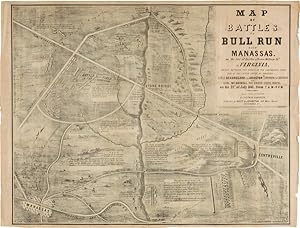
Sheet map, 19 3/4 x 26 inches. Old fold lines. Some separation at two folds on the right edge. Light wear, minor toning. Very good. A handsome and historic map depicting the First Battle of Manassas, or Bull Run, depicting troop positions and movements, roads, railroads, houses, and other significant geographical features. First Manassas was the first significant engagement of the Civil War, and the place where Thomas J. Jackson became "Stonewall" Jackson when his brigade stood their ground against disorganized Union forces. The Confederate troops won the battle, raising hopes in the South and signaling to the North that the war would not be won so easily. The map indicates that it was "made from observation" by Solomon Bamberger, and lithographed by the firm of Hoyer & Ludwig in Richmond. It appears that at least two issues of this map exist, this being the most vividly pictorial that we have found and thus, perhaps, the later of the two. Rather than a simple plan of the battle, the present map lays out the same information, augmenting the background with shading and pictorial scenery. The title is likewise enclosed in a simple border, setting it off from the rest of the map, and though the title is the same, the typeface of some of the title lettering has been changed slightly. Parrish & Willingham do not indicate any differentiation of issues, but the details and graphics make this by far the most desirable. A rare and interesting map of this important battle, and one of the most dramatic graphics produced in the Confederacy. Without the means to produce suitable paper, few pieces on a comparable scale were created. PARRISH & WILLINGHAM 6148. Seller Inventory # WRCAM48993
Contact seller
Report this item
![]()
