About this Item
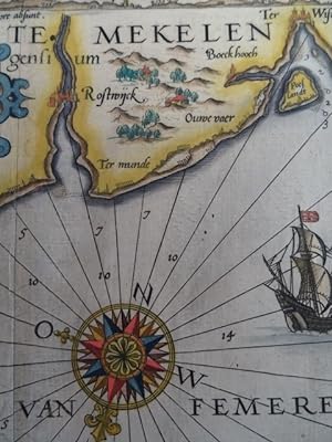
Koeman Wa II, 41 c; Tooley S. 376.- Dekorative Seekarte der deutschen und dänischen Ostseeküste, im Norden und Westen begrenzt durch Mecklenburg bzw. Rügen, im Osten durch Holstein und Fehmarn sowie im Süden durch die dänischen Inseln Mon, Falster und Lolland.- Zeigt die Küste mit ihren Fahrwassern und Untiefen.- Mittig mit schöner Windrose sowie mit Segelschiffen und 2 Seetieren. Im oberen Rand mit Profil des Hinterlandes (dabei auch Lübeck), ferner mit Meilenzeiger sowie 2 weiteren Textkartuschen.;$$;Baltic Sea - Caerte van de zee Custe van Mekelenborch . De Custe van Lalandt, met de omligghende Eijlanden . Colored copper engraving map by Johan van Doetichum for Lucas Jansz Waghenaer. 1591. 33 x 51.5 cm. 'Koeman Wa II, 41 c; Tooley p. 376.- Decorative sea chart of the German and Danish Baltic Sea coast, bounded in the north and west by Mecklenburg and Rügen resp., in the east by Holstein and Fehmarn and in the south by the Danish islands Mon, Falster and Lolland.- Showing the coast with its fairways and shallows.- In the center with fine wind rose as well as with sailing ships and 2 sea animals. In the upper margin with profile of the hinterland (including Lübeck), also with mileage indicator and 2 further text cartouches.' Sprache: Deutsch Gewicht in Gramm: 500. Seller Inventory # 62342
Contact seller
Report this item
![]()


