Order Total (1 Item Items):
Shipping Destination:

Le Cours Du Danube (33 results)
Skip to main search results
Product Type
- All Product Types
- Books (14)
- Magazines & Periodicals (1)
- Comics
- Sheet Music
- Art, Prints & Posters (6)
- Photographs
- Maps (12)
-
Manuscripts &
Paper Collectibles
Condition
Binding
Collectible Attributes
- First Edition (1)
- Signed
- Dust Jacket
- Seller-Supplied Images (29)
- Not Printed On Demand (32)
Free Shipping
Seller Location
Seller Rating
-
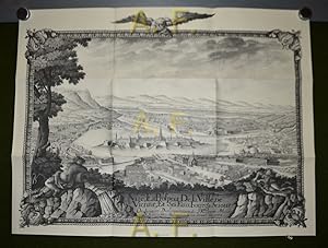
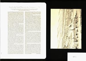
Ansicht der Stadt Wien mit den Vorst�dten, lavierte Tuschfederzeichung aus: "Atlas du cours du Danube avec les plans, vues et perspective des villes, ch�teaux et abbayes (.) par F. N. de Sparr", 1742, �sterreichisches Staatsarchiv // Faksimile Ausgabe - Kopie (Nachdruck)
Published by Wien, Archiv Verlag, 1997
Art / Print / Poster
Broschiert. 1 Blatt (gefalten) Blattgr��e = ca. 60 x 45,5 cm / gutes Exemplar // �sterreich G1007 *.* Sprache: Deutsch Gewicht in Gramm: 200.
-

Ansicht der Stadt Wien mit den Vorst�dten, lavierte Tuschfederzeichung aus: "Atlas du cours du Danube avec les plans, vues et perspective des villes, ch�teaux et abbayes (.) par F. N. de Sparr", 1742, �sterreichisches Staatsarchiv // Faksimile Ausgabe - Kopie (Nachdruck)
Published by Wien, Archiv Verlag, 1997
Art / Print / Poster
Broschiert. 1 Blatt (gefalten) Blattgr��e = ca. 60 x 45,5 cm / gutes Exemplar // �sterreich G1025 *.* Sprache: Deutsch Gewicht in Gramm: 200.
-
Condition: Good. GERMANY.Danube, Hochstadt Dillingen Wertingen Lauingen 1859 old antique map. Antique engraved map; Engraved by Ch. Dyonnet; drawn by A.H. Dufour (1859). 22.0 x 29.5cm, 8.5 x 11.75 inches. Condition: Good. There is nothing printed on the reverse side, which is plain.
-
Softcover. Faksimile-Sammlung bestehend aus Nachdruck(en) und einem dazugeh�rigen Text. SEHR GUTER Zustand, kaum Gebrauchsspuren. (75) �ed Sprache: Deutsch Gewicht in Gramm: 330.
-

Le cours du Danube - en 2888 kilom�tres/vers. l'infini
Published by PRESSES DU REEL, 2018
ISBN 10: 2378960131ISBN 13: 9782378960131
Book
Condition: Neuf.
More buying choices from other sellers on AbeBooks
New offers from � 15.04
-
![Seller image for D'Essling a Wagram: Lasalle; correspondance recueillie par Robinet de Clery. Avec 13 gravures et une carte du cours du Danube de Vienne a Raab dressee par m. le capitaine Matuszinski (1891) [Leatherbound] for sale by S N Books World](https://pictures.abebooks.com/inventory/md/md30637866157.jpg)
Leatherbound. Condition: NEW. Leatherbound edition. Condition: New. Leather Binding on Spine and Corners with Golden leaf printing on spine. Bound in genuine leather with Satin ribbon page markers and Spine with raised gilt bands. A perfect gift for your loved ones. Reprinted from 1891 edition. NO changes have been made to the original text. This is NOT a retyped or an ocr'd reprint. Illustrations, Index, if any, are included in black and white. Each page is checked manually before printing. As this print on demand book is reprinted from a very old book, there could be some missing or flawed pages, but we always try to make the book as complete as possible. Fold-outs, if any, are not part of the book. If the original book was published in multiple volumes then this reprint is of only one volume, not the whole set. IF YOU WISH TO ORDER PARTICULAR VOLUME OR ALL THE VOLUMES YOU CAN CONTACT US. Resized as per current standards. Sewing binding for longer life, where the book block is actually sewn (smythe sewn/section sewn) with thread before binding which results in a more durable type of binding. Pages: 298 Language: French Pages: 298.
-
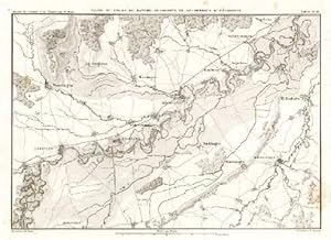
Carte du Cours du Danube, au-dessous d`H�chstett. Stahlstichkarte von A.H.Dyonnet nach A.H.Dufour.
Published by Paris 1859., 1859
Art / Print / Poster
22,0 x 29,0 cm. Im wei�en Rand leicht stokfleckig. Aus : Adolphe Thiers - Atlas de l'Histoire du Consulat et de l'Empire. Umfa�t die Gegend von Wittislingen, Bergheim, H�chstett, Blindheim, Schwenningen, Tapfheim, Gremheim, Pfaffenhofen, Wertingen, Binwangen, Lawingen, Dillingen, Schetzheim und Kicklingen. [SW - Landkarte, Landkarten].
-
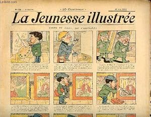
La Jeunesse Illustr�e - n� 169 - 20 mai 1906 - Chien et chat par Espagnat - les bouches du Danube par Kotek - Comment Marius a r�fl�chi par Moriss - La caverne myst�rieuse par Monnier - La l�gende du t�l�graphe par Leguey - Voyage au long cours par Rabier
Published by A. Fayard, 1906
Magazine / Periodical
Pas de couverture. Condition: bon. RO70309819: 1906. In-Folio. En feuillets. Etat d'usage, Livr� sans Couverture, Dos frott�, Papier jauni. 12 pages illustr�es en couleurs et en noir et blanc dans le texte - sur 3 colonnes -. . . . Classification Dewey : 70.49-Presse illustr�e, magazines, revues.
-
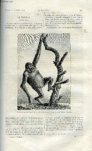
Couverture souple. Condition: bon. RO10024867: 4 mars 1876. In-12. Broch�. Bon �tat, Livr� sans Couverture, Dos satisfaisant, Mouillures. Pagin� de 209 � 224. Quelques gravures en noir et blanc dans et hors texte. . . . Classification Dewey : 500-SCIENCES DE LA NATURE ET MATHEMATIQUES.
-

br. (2) ff., 222 pp., 13 pl. h. t., carte d�pl., grand tableau g�n�alogique repli� dans une bande contrecoll�e sur la 3e de couv., qqs. rouss.
-
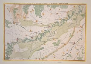
Carte du Cours du Danube, audessus et au-dessus d'H�chstett
Published by Artist: Dyonnet Charles ( - 1880 ) Paris ; issued in: Paris ; ca: 1840; - Charles Dyonet was a successful and highly productive French engraver He engraved for various publishers including Vuillemin and Dufour, 1822
Seller: Antique Sommer& Sapunaru KG, M�nchen, Germany
Seller Rating:

Technic: Steel engraving; colorit: original colored; condition: Perfect condition, size (in cm): 21,5 x 29 cm; - Map shows the course of the Danube in Swabia from Lauingen via Dillingen, past H�chst�dt, Blindheim and Gremheim. Published by A. H. Dufour.
-
D'Essling � Wagram. Lasalle. Correspondance recueillie par Robinet de Cl�ry. Avec 13 gravures et une carte du cours du Danube de Vienne � Raab dress�e par le capitaine Matuszinski.
Published by Berger-Levrault, Paris, Nancy, 1891
First Edition
In-8 de (4)-222 pp., premier plat de couverture conserv�e, demi-veau rouge, dos orn� � nerfs (reliure moderne). Edition originale. Carte du Danube d�pliante et 13 planches hors-texte. La couverture sert de titre. Bel exemplaire.
-
RAISON, FOLIE, PETIT COURS DE MORALE mis a la portee des vieux enfans. Suivi des Observateurs de la femme. Augmentee de quelques dissertations a peu pres philosophiques, et de quatre contes inedits: la Nourriture d'un Prince, ou le Danger des coutumes etrangeres; le Pecheur du Danube; le Jardinier de Samos, ou le Pere du Senat; l'Enfant de Europe, ou le Diner des Liberaux a Paris, en 1814.
Published by Deterville,, Parigi,, 1816
Seller: SCRIPTORIUM Studio Bibliografico, Mantova, MN, Italy
Seller Rating:

2 voll. in-8, pp. XXVII, 404; 446, leg. m. pelle coeva con fregi e tit. oro al d. Piatti in carta dec. In questa terza ediz. (la prima e la seconda sono entrambe del 1801), il secondo vol. contiene, con l'eccezione dell' Observateurs de la Femme, parti inedite. Barbier IV, 3. [cat07-276].
-
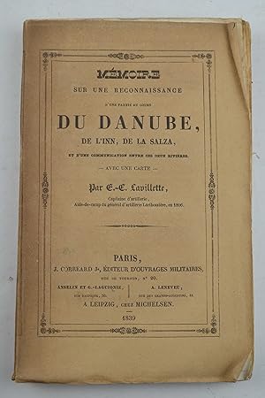
M�moire sur une reconnaissance d'une partie du cours du Danube, de l'Inn, de la Salza, et d'une communication entre ces deux rivi�res. - Avec une carte -.
Published by Correard,, Paris,, 1839
Seller: Studio Bibliografico Benacense, Riva del garda, Italy
Seller Rating:
Cm. 22, pp. viii, 132 (4), iv, iv. Con una grande carta topografica in litografia pi� volte ripiegata. Brossura originale a stampa. Ben conservato. Legati in fine due piccoli (4 pagine ciascuno) ed interessanti cataloghi di librai del tempo datati 1839 ed in forma di manoscritto, riguardanti liste di libri di arte militare proposte da due librerie parigine del tempo.
-
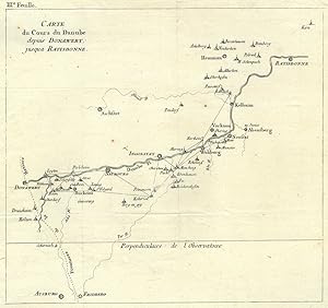
DONAU. - Karte. "Carte du Cours du Danube depuis Donauwert jusqua Ratisbonne". Die Karte zeigt den Donaulauf von Donauw�rth bis Regensburg.
Seller: Peter Bierl Buch- & Kunstantiquariat Inh.: Andrea Bierl, Eurasburg, Germany
Seller Rating:
Art / Print / Poster
Kupferstich, um 1760, 24 x 26 cm. Vgl. Cartographia Bavariae, Abb. 102. - Die Ortschaften sind gem�� der Triangulationsvermessung nach C�sar Fran�ois Cassini de Thury (1714 - 1784) durch ein Netz von Dreiecken miteinander verbunden. - Oben links "III.e Feuille". - Selten.
-
74 x 49 cm. Condition: Gut. Erstauflage, EA. 1 Blatt Kupferstich-Landkarte mit Passepartout, Rahmen 74 x 49 cm, mit Rahmen 85 x 60 cm, guter Zustand Sprache: Deutsch Gewicht in Gramm: 1100.
-
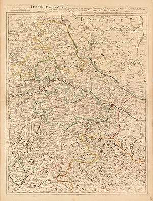
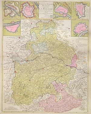
Le Cercle de Baviere Comprenant tout les Etats apartenant � L Electeur de Baviere au Palatin du Rhein au Palatin de Sultzbach L`Archeveche de Salzbourg les Evech�es de Passau Frissinge & Cours du Danube depuis Dannavert jusqu� Lintz Dress�e sur les Memoires des plus nouveaux par Crepy Geographe 1735
Published by Crepy, Paris, 1735
Seller: Antiquariat Reinhold Berg eK Inh. R.Berg, Regensburg, Germany
Seller Rating:
Map
Other. Original antike Kupferstichkarte, in zeitgen�ssischem Grenzkolorit. Nach dem Kartenbild von Hubert Jaillot. Dargestellt wird der bayrische Kreis im Norden mit dem benachbarten Tschechien, die St�dte Eger und Prag und im S�den bis nach Innsbruck. Im Osten von Budweis bis N�rnberg im Westen. Das Kartenbild sorgf�ltig und �bersichtlich ausgearbeitet. In ausgezeichnetem Zustand. Leicht gebr�unt. 665 by 505mm (26� by 20 inches).
-
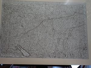
8� , unbekannter Einband. 1.Auflage,. gefaltete Karte, Gr��e ca. 120 x 75 cm, auf Leinen kaschiert in 8x4 Segmenten, etwas angestaubt und fleckig, an den Ecken mit kl.Durchstichen, insgesamt guter Zustand Sprache: Franz�sisch Gewicht in Gramm: 270.
-
mit altem Grenzkolorit, dat. 1705, 48,5 x 74 Pastoureau Jai IIE. - �ber der Karte Kopftitel. - Zeigt das Gebiet zwischen Ansbach, Straubing, Kempten, Freudenstadt/Schwarzw. Mittig Donauw�rth sowie das Gebiet von bay. Schwaben. Im S�dwesten der Bodensee.
-
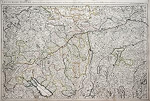
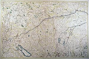
Cours du Danube Feuille Ile. Contenant La Baviere.
Published by Artist: Le Rouge Georges Louis ( - 1790 ) Paris ; issued in: Paris ; dated: 1742; - Georges Louis Le Rouge (ca 1707 -1790) He was established as a publisher compiler and editor of maps in Paris He later became the Ingenieur Geographe de Roi Le Rouge is particularly known for such atlas works as the Atlas Nouveau of 1746 and the Atlas Nouveau Portatif or the Introduction A La Geographie of 1756 French publications of some merit, 1707
Seller: Antique Sommer& Sapunaru KG, M�nchen, Germany
Seller Rating:
Technic: Copper print; colorit: original colored; condition: Perfect condition, size (in cm): 64,5 x 51; - Map depicts total Bavaria and the area of Salburg ( Austria). With 5 city maps, Salzburg, Munich, Regensburg, Donauwoerth, Lauingen and rain. Georges Louis Le Rouge (ca 1707 -1790) He was established as a publisher, compiler and editor of maps in Paris. He later became the Ingenieur Geographe de Roi. Le Rouge is particularly known for such atlas works as the Atlas Nouveau of 1746 and the Atlas Nouveau Portatif or the Introduction A La Geographie of 1756. French publications of some merit.
-
Kupferstich- Karte, v. u. b. Pierre Duval, "Le Cours du Danube ou sont La Baviere, L'Austriche et la Boheme".
Seller: Antiquariat Clemens Paulusch GmbH, Berlin, Germany
Seller Rating:
Map
mit altem Grenzkolorit, dat. 1684, 39,5 x 52 Pastoureau Duval II F, 77. H�bsche Karte des Donaulaufes von Donauw�rth bis Visegrad, zeigt mit Ausnahme von Vorarlberg das Staatsgebiet des heutigen �sterreich, im S�den bis Triest, im Norden bis Prag; die Karte erschien so als Einzelblatt und war wohl gedacht einer nicht mehr realisierten Karte des gesamten Donaulaufes.
-
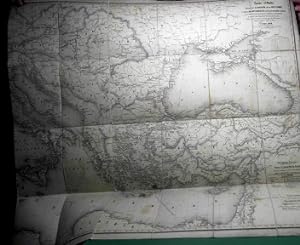
Lithografie- Karte, "Carte r�duite du cours du Danube de la Mer Noire et de la Mediterran�e � l'est du meridien de Paris, avec l'indication des principales enterprises de navigation � vapeur qui fr�quentent les mers du Levant".
Seller: Antiquariat Clemens Paulusch GmbH, Berlin, Germany
Seller Rating:
Map
mit altem Grenzkolorit, 1840, 74 x 118,5 Gro�formatige Verkehrskarte des Mittelmeers von den Balearen bis zur Levante, reicht im Norden bis W�rzburg, im S�den bis Alexandria; urspr�nglich in 4 Blatt erschienen, in Segmente zerschnitten und auf Leinen aufgezogen; abgesehen von einigen Quetschfalten von guter Erhaltung.
-

Vienne a une partie du cours du danube au .??. ville (verso mit Tusche bezeichnet u. "No.42"). Anonyme Manuskriptkarte, Tusche u. Aquarell, um 1740, 34 x 50 cm
Seller: Antiquariat Johannes M�ller, Salzburg, Austria
Seller Rating:
Map
Umgebungskarte v. Wien mit Lobau u. Marchfeld sowie Donaulauf bis Fischamend, ohne Beschriftungen mit Ortschaften u. Strassen.- Alte Faltung (Faltungseinrisse tls. hinterlegt), leicht fleckig.# Manuscript map.-.
-
M�moire sur une reconnaissance d'une partie du cours du Danube de l'Inn, de la Salza, et d'une communication entre ces deux rivi�res. - Avec une carte
Published by Paris, J. Corr�ard junior, 1839, 1839
in-8, VIII pp., [180] pp. mal chiffr�es 132, avec une grande carte d�pliante, demi-veau noir � coins, dos � nerfs orn� de filets et guirlandes dor�s, tranches mouchet�es Cachets, mais bon exemplaire. (reliure de l'�poque). Unique �dition, posthume, fort peu commune. Le capitaine d'artillerie Lavillette �tait un des aides-de-camp du g�n�ral Lariboisi�re et il p�rit comme ce dernier au cours de la campagne de Russie de 1812. Mais, en 1806, il avait �t� charg� d'effectuer cette reconnaissance du Danube de Passau � Linz.Un seul exemplaire au CCF (BnF). LIVRE NON DISPONIBLE � PARIS, VENTE PAR CORRESPONDANCE UNIQUEMENT.
-
DONAU. - Karte. "Le Cours du Danube, depuis sa Source jusques a Straubing".
Seller: Peter Bierl Buch- & Kunstantiquariat Inh.: Andrea Bierl, Eurasburg, Germany
Seller Rating:
Art / Print / Poster
Altkol. Kupferstich bei Jaillot, um 1700, 48 x 73 cm. Zeigt sehr detailliert den Donaulauf vom Ursprung bis kurz vor Straubing und das Gebiet von Ansbach im Norden bis Winterthur und dem Walchensee im S�den. Mit Kopftitel. Gering faltig, sonst gut erhalten.
-
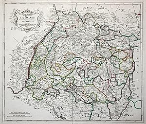
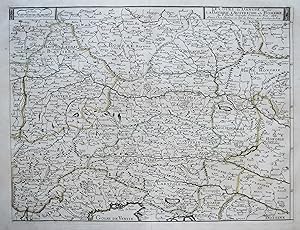
Kupferstich- Karte, v. Le Rouge, "Cours du Danube Feuille I. Contenant La Suabe ou est exactement marqu�e la succession de Charles VI.".
Seller: Antiquariat Clemens Paulusch GmbH, Berlin, Germany
Seller Rating:
Map
mit altem Grenzkolorit, dat. 1742, 48 x 56 Klassische Karte des Schw�bischen Reichskreises, reicht von Mannheim im Norden bis Eschen in Lichtenbstein im S�den, von Strassbourg im Westen bis Augsburg im Osten. Selten, wie alle gro�formatigen Karten von Le Rouge.
-
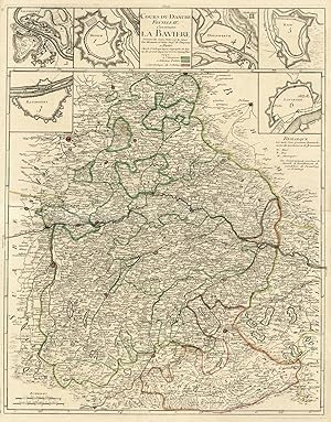
Cours Du Danube Feuille IIe. Contenant La Baviere Suivant les Cartes faites sur les lieux. Par Homann et Seuter Geoes. de l'Empereur A Paris Chez le Sr. le Rouge Ingenr. Geographe du Roy rue des grands Augustins vis a vis le panier fleuri 1742.':.
Seller: Antiquariat Norbert Haas, Bedburg-Hau, Germany
Seller Rating:
Map
Altkolorierter Kupferstich aus Atlas G�n�ral . b. Le Rouge in Paris, dat. 1742, 65 x 51 Schaup, Salzburg auf alten Landkarten, 4.14; Tooley's Dic. of Mapm. S. 389. - Zeigt Nieder- und Oberbayern mit der Oberpfalz. - Am oberen Kartenrand Titel und 6 Pl�ne bzw. Befestigungspl�ne (je ca 10 x 10 cm) von Regensburg, Salzburg, M�nchen, Donauw�rth, Rain am Lech und Lauingen. - Unten links Ma�stab.
-

DONAU. - Karte. "Le Cours du Danube du sont La Baviere, L'Austriche et la Boheme".
Seller: Peter Bierl Buch- & Kunstantiquariat Inh.: Andrea Bierl, Eurasburg, Germany
Seller Rating:
Art / Print / Poster
Altkol. Kupferstich von Pierre Duval, dat. 1684, 40 x 53,5 cm. Zeigt den Donaulauf von Donauw�rth bis Gran in Ungarn, im S�den bis zum Golf von Venedig reichend. - Seltene Karte in feinem alten Fl�chenkolorit.
-
mit Fl�chenkolorit, dat. 1705, 49 x 145 Pastoureau Jai II E ( Karte 196 und 197 ).- �ber der Karte Kopftitel in franz. Sprache. Dargestellt ist die Donau von der Quelle bis Wien.
-
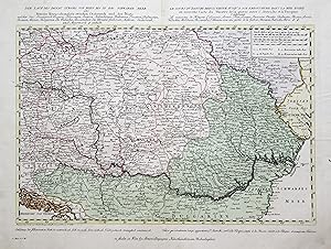
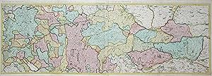
Kst.- Karte, n. v. Fr. M�ller bei Artaria in Wien, "Der Lauf des Donau Stroms von Wien bis in das Schwarze Meer oder Neuester Kriegsschauplatz zwischen Osterreich und der Pforte, welcher das Koenigreich Ungarn, Sclavonien, Sirnien, Siebenb�rgen, Bujowina, Croatien, Dalmatien. Bosnien, Servien, Bulgarien, die Walachei, Bessarabien, die Ukraine, Galizien, M�hren, Oesterreich, und Steyermark, & enth�lt. - Le Cours du Danube .".
Seller: Antiquariat Clemens Paulusch GmbH, Berlin, Germany
Seller Rating:
Map
mit altem Fl�chenkolorit, 1788, 33,5 x 51 D�rflinger, Art. 7; Szantai, Atlas Hungaricus, Artaria 2. - Seltener Einblattdruck und zugleich eine der fr�hestens von Artaria herausgegebenen Karten, zeigt den Donaulauf zwischen Wien und der M�ndung, im S�dwesten die Adria. �ber der Karte Kopftitel in deutscher und franz. Sprache, unter der Karte Erkl�rungen zu den Farben ("Roth ist osterreichisch" usw.). Ausgezeichnetes Exemplar.