
Order Total (1 Item Items):
Shipping Destination:

Wymond, Charles E (57 results)
Skip to main search results
Product Type
- All Product Types
- Books (57)
- Magazines & Periodicals
- Comics
- Sheet Music
- Art, Prints & Posters
- Photographs
- Maps
-
Manuscripts &
Paper Collectibles
Condition
Binding
- All Bindings
- Hardcover (11)
- Softcover
Collectible Attributes
- First Edition (1)
- Signed
- Dust Jacket
- Seller-Supplied Images (46)
- Not Printed On Demand (56)
Free Shipping
Seller Location
Seller Rating
-
![Seller image for Atlas of Railway Traffic Maps . (1919) [LeatherBound] for sale by True World of Books](https://pictures.abebooks.com/inventory/md/md31657482785.jpg)
LeatherBound. Condition: New. LeatherBound edition. Condition: New. Reprinted from 1919 edition. Leather Binding on Spine and Corners with Golden leaf printing on spine. Bound in genuine leather with Satin ribbon page markers and Spine with raised gilt bands. A perfect gift for your loved ones. NO changes have been made to the original text. This is NOT a retyped or an ocr'd reprint. Illustrations, Index, if any, are included in black and white. Each page is checked manually before printing. As this print on demand book is reprinted from a very old book, there could be some missing or flawed pages, but we always try to make the book as complete as possible. Fold-outs, if any, are not part of the book. If the original book was published in multiple volumes then this reprint is of only one volume, not the whole set. Sewing binding for longer life, where the book block is actually sewn (smythe sewn/section sewn) with thread before binding which results in a more durable type of binding. Pages: 72 La Salle Extension University, Charles E . Wymond.
-
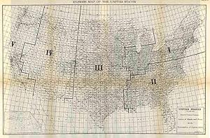
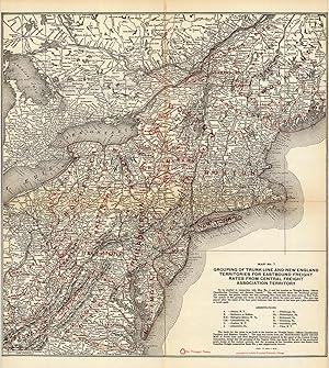
United States, System of Blocks and Zones for the Formulation of Express Rates
Publication Date: 1924
Charles E. Wymond produced this "Atlas of Traffic Maps" in 1924. The Atlas contains maps covering routes and rate classification groupings of the various transportation agencies. The United States System of Blocks and Zones for the Formulation of Express Rates is illustrated on this large very detailed map. Cities, towns, geographic features, train stations, railroad lines, major roads, and localized industrial staples are also shown. An inset map of Alaska is also included on this map. This map measures 16.5 inches by 25.75 inches.
-

ATLAS OF RAILWAY TRAFFIC MAPS. This Atlas of Railway Traffic Maps is One of a Series of Texts on Interstate Commerce and Railway Traffic.
Published by LaSalle Extension University
Seller: Wonder Book, Frederick, MD, U.S.A.
Seller Rating:

Condition: Good. Good condition. (railway maps).
-
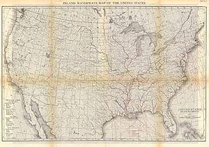
Charles E. Wymond produced this "Atlas of Traffic Maps" in 1924. The Atlas contains maps covering routes and rate classification groupings of the various transportation agencies. The United States inland waterways are illustrated on this large, very detailed map. Cities, towns, geographic features, train stations, railroad lines, major roads, and localized industrial staples are also shown. This map measures 17.5 inches by 26.25 inches.
-
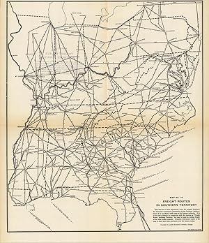
Charles E. Wymond produced this "Atlas of Traffic Maps" in 1924. The Atlas contains maps covering routes and rate classification groupings of the various transportation agencies. The Freight Routes and Junction Points in Southern Territory are illustrated on this large very detailed map. Cities, towns, geographic features, train stations, railroad lines, major roads, and localized industrial staples are also shown. This map measures 19.5 inches by 16.5 inches.
-
Hardcover. Condition: Fair. No Jacket. Octavo. Contains 26 maps, many folding. Slim hardback bound in burgundy cloth. The binding is worn and spotted. Front inner hinge is cracked, and the binding is shaken. Contains color maps. Some of the larger folding maps are torn and folded with wrinkles and some have chips missing. Many of the maps, especially the smaller ones, are presentable. Front inner hinge is cracked, and the binding is shaken.
-
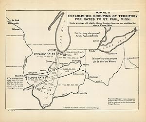
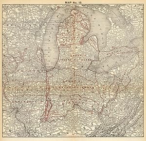
Charles E. Wymond produced this "Atlas of Traffic Maps" in 1924. The Atlas contains maps covering routes and rate classification groupings of the various transportation agencies. This map covers the grouping of territory for rates to St. Paul, Minnesota. Cities, towns, geographic features, train stations, railroad lines, major roads, and localized industrial staples are also shown. This map measures 7.5 inches by 10 inches.
-

Charles E. Wymond produced this "Atlas of Traffic Maps" in 1924. The Atlas contains maps covering routes and rate classification groupings of the various transportation agencies. The Western Truck Line Committee Territory is illustrated on this large, very detailed map. Cities, towns, geographic features, train stations, railroad lines, major roads, and localized industrial staples are also shown. This map measures 12.5 inches by 13.5 inches.
-
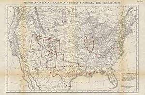
Charles E. Wymond produced this "Atlas of Traffic Maps" in 1924. The Atlas contains maps covering routes and rate classification groupings of the various transportation agencies. Minor and Local Railroad Freight Association Territories are illustrated on this large, very detailed map. Cities, towns, geographic features, train stations, railroad lines, major roads, and localized industrial staples are also shown. This map measures 18.75 inches by 13 inches.
-

Charles E. Wymond produced this "Atlas of Traffic Maps" in 1924. The Atlas contains maps covering routes and rate classification groupings of the various transportation agencies. This large, very detailed map shows the Percentage Bases for Westbound Rates. Cities, towns, geographic features, train stations, railroad lines, major roads, and localized industrial staples are also shown. This map measures 16.5 inches by 17.5 inches.
-
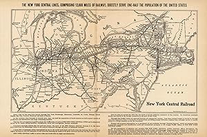
Charles E. Wymond produced this "Atlas of Traffic Maps" in 1924. The Atlas contains maps covering routes and rate classification groupings of the various transportation agencies. The New York Central Lines are illustrated on this large, very detailed map. Cities, towns, geographic features, train stations, railroad lines, major roads, and localized industrial staples are also shown. This map measures 10.25 inches by 15.25 inches.
-

Charles E. Wymond produced this "Atlas of Traffic Maps" in 1924. The Atlas contains maps covering routes and rate classification groupings of the various transportation agencies. This large, very detailed map shows C.F.A. Territorial Grouping for Southbound Rates. Cities, towns, geographic features, train stations, railroad lines, major roads, and localized industrial staples are also shown. This map measures 16.5 inches by 17.5 inches.
-
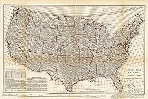
Charles E. Wymond produced this "Atlas of Traffic Maps" in 1924. The Atlas contains maps covering routes and rate classification groupings of the various transportation agencies. The Parcel Post Rate Map of the United States is illustrated on this large, very detailed map. Cities, towns, geographic features, train stations, railroad lines, major roads, and localized industrial staples are also shown. This map measures 18.25 inches by 26.75 inches.
-
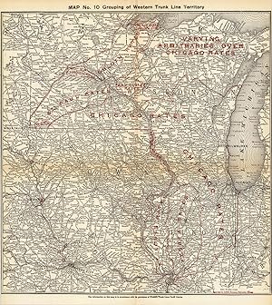
Charles E. Wymond produced this "Atlas of Traffic Maps" in 1924. The Atlas contains maps covering routes and rate classification groupings of the various transportation agencies. Grouping of Western Trunk Line Territory is illustrated on this large, very detailed map. Cities, towns, geographic features, train stations, railroad lines, major roads, and localized industrial staples are also shown. This map measures 19.25 inches by 18.5 inches.
-

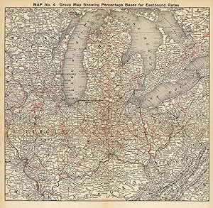
Charles E. Wymond produced this "Atlas of Traffic Maps" in 1924. The Atlas contains maps covering routes and rate classification groupings of the various transportation agencies. This large, very detailed map shows the percentage bases for Eastbound Rates. Cities, towns, geographic features, train stations, railroad lines, major roads, and localized industrial staples are also shown. This map measures 16.5 inches by 17.5 inches.
-
Hardcover. Condition: Good. maroon cloth binding, gold stamped. Great collection of fold-outrailroad traffic maps. Oversized. maps. good, maps intact but missing all pages prior to preface page. unpaged. Book.
-
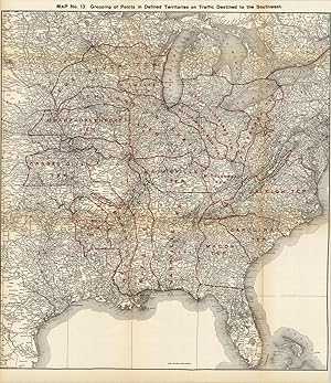
Charles E. Wymond produced this "Atlas of Traffic Maps" in 1924. The Atlas contains maps covering routes and rate classification groupings of the various transportation agencies. This map focuses on the grouping points in the western half of the United States. Cities, towns, geographic features, train stations, railroad lines, major roads, and localized industrial staples are also shown. This map measures 25.5 inches by 23 inches.
-
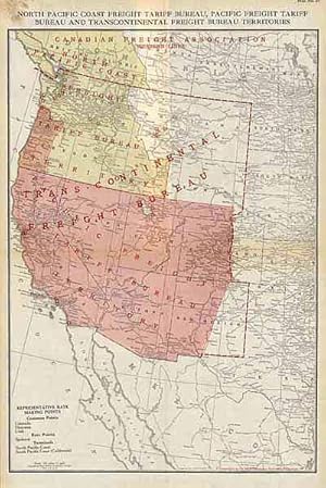
Charles E. Wymond produced this "Atlas of Traffic Maps" in 1924. The Atlas contains maps covering routes and rate classification groupings of the various transportation agencies. The North Pacific Coast Freight Tariff Bureau, Pacific Freight Tariff Bureau and Transcontinental Bureau Territories are illustrated on this large, very detailed map. Cities, towns, geographic features, train stations, railroad lines, major roads, and localized industrial staples are also shown. This map measures 18.5 inches by 13 inches.
-
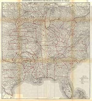
Charles E. Wymond produced this "Atlas of Traffic Maps" in 1924. The Atlas contains maps covering routes and rate classification groupings of the various transportation agencies. Territorial Groupings for traffic destined to Texas are illustrated on this large, very detailed map. Cities, towns, geographic features, train stations, railroad lines, major roads, and localized industrial staples are also shown. This map measures 25.25 inches by 23 inches.
-
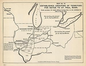
This hard to find map shows the established grouping of Territory for rates to St. Paul, Minn. It was created by Charles E. Wymond for the "Atlas of Railway Traffic Maps" in 1919. The Atlas contains maps covering routes and rate classification groupings of the various transportation agencies. The map shows rail lines stretching across parts of the mid-west and rates. Cities, towns, train stations, and various geographic features are also shown. This map measures 7.75 inches by 10.25 inches.
-
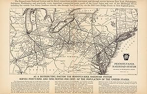
Charles E. Wymond produced this "Atlas of Traffic Maps" in 1924. The Atlas contains maps covering routes and rate classification groupings of the various transportation agencies. The Pennsylvania Railroad System is illustrated on this large, very detailed map. Cities, towns, geographic features, train stations, railroad lines, major roads, and localized industrial staples are also shown. This map measures 10.5 inches by 15.25 inches.
-
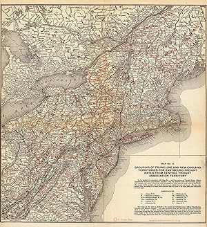
This hard to find map shows the grouping of the Trunk Line and New England Territories for Eastbound Freight Rates from Central Freight Association Territory. It was created by Charles E. Wymond for the "Atlas of Railway Traffic Maps" in 1919. The grouping of traffic territories for rate adjustments shown in this atlas is explained in the treaties devoted to freight classification and rates and forming a part of the course in Interstate Commerce and Railway Traffic. This map measures 19.5 inches by 18.5 inches.
-
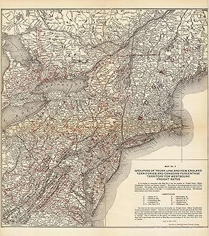
Charles E. Wymond produced this "Atlas of Traffic Maps" in 1924. The Atlas contains maps covering routes and rate classification groupings of the various transportation agencies. Grouping of Trunk Line and New England Territories and Canadian Percentage Territory for Westbound Freight Rates are illustrated on this large, very detailed map. Cities, towns, geographic features, train stations, railroad lines, major roads, and localized industrial staples are also shown. This map measures 20.5 inches by 18.5 inches.
-
Grouping of Trunk Line and New England Territories for Eastbound Freight Rates
Publication Date: 1924
Charles E. Wymond produced this "Atlas of Traffic Maps" in 1924. The Atlas contains maps covering routes and rate classification groupings of the various transportation agencies. Grouping of Trunk Line and New England Territories for Eastbound Freight Rates are illustrated on this large, very detailed map. Cities, towns, geographic features, train stations, railroad lines, major roads, and localized industrial staples are also shown. This map measures 19.25 inches by 18.25 inches.
-
27 maps. 12 x 10", dark red cloth, gilt lettering on front cover, title page, index plus maps. Covers shelfworn, stained, corners and spine tips bumped and worn, inner hinges cracked, text block becoming detached at rear inner hinge, dirt soiling to front pastedown through index, maps have edge tears, tears along folds and chipping along edges else good to very good condition. EX-LIBRARY- "Dept. of Traffic Management" written inside front cover. Some of the maps: "Industrial Map Of The United States", "Union Pacific System", "Grouping Of Western Trunk Line Territory", "Freight Routes In Southern Territory", "Map Of Steamship Routes Of The World.".
-
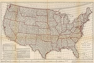
This hard to find map shows the parcel post rate throughout the United States. It was created by Charles E. Wymond for the "Atlas of Railway Traffic Maps" in 1919. The Atlas contains maps covering routes and rate classification groupings of the various transportation agencies. This highly detailed map shows states, cities, rates, and includes a key that provides in-depth information. This map measures 17.75 inches by 27 inches.
-
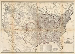
This hard to find map shows the Territorial Groups shown in Westbound Trans-Continental Tariff No. 1-Q. It was created by Charles E. Wymond for the "Atlas of Railway Traffic Maps" in 1919. The grouping of traffic territories for rate adjustments shown in this atlas is explained in the treaties devoted to freight classification and rates, and forming a part of the course in Interstate Commerce and Railway Traffic. This map measures 19 inches by 27 inches.
-
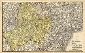
This hard to find map of Central Freight Association Territory was created by Charles E. Wymond for the "Atlas of Railway Traffic Maps" in 1919. The Atlas contains maps covering routes and rate classification groupings of the various transportation agencies. The area in yellow marks the Central Freight Association Territory. States, cities, towns, train stations, railroad lines, major roads, and various geographic features are also shown. This map measures 10.5 inches by 17 inches.
-
This hard to find map shows the percentage bases for Eastbound Rates. It was created by Charles E. Wymond for the "Atlas of Railway Traffic Maps" in 1919. The Atlas contains maps covering routes and rate classification groupings of the various transportation agencies. States, cities, towns, train stations, railroad lines, major roads, and various geographic features are also shown. This map measures 16.75 inches by 17.5 inches.
-
This hard to find map shows the groups in Central Freight Association Territory. It was created by Charles E. Wymond for the "Atlas of Railway Traffic Maps" in 1919. The Atlas contains maps covering routes and rate classification groupings of the various transportation agencies. This map measures 16.75 inches by 17.5 inches.
