
Order Total (1 Item Items):
Shipping Destination:

Weiland, C F (73 results)
Skip to main search results
Product Type
- All Product Types
- Books (59)
- Magazines & Periodicals
- Comics
- Sheet Music
- Art, Prints & Posters (1)
- Photographs
- Maps (13)
-
Manuscripts &
Paper Collectibles
Condition
Binding
Collectible Attributes
Free Shipping
Seller Location
Seller Rating
-
![Seller image for C. Marii VII Cos. vita (1845) [Leatherbound] for sale by S N Books World](https://pictures.abebooks.com/inventory/md/md30637733081.jpg)
Leatherbound. Condition: NEW. Leather Binding on Spine and Corners with Golden leaf printing on spine. Bound in genuine leather with Satin ribbon page markers and Spine with raised gilt bands. A perfect gift for your loved ones. Reprinted from 1845 edition. NO changes have been made to the original text. This is NOT a retyped or an ocr'd reprint. Illustrations, Index, if any, are included in black and white. Each page is checked manually before printing. As this print on demand book is reprinted from a very old book, there could be some missing or flawed pages, but we always try to make the book as complete as possible. Fold-outs, if any, are not part of the book. If the original book was published in multiple volumes then this reprint is of only one volume, not the whole set and contains approximately 38 pages. IF YOU WISH TO ORDER PARTICULAR VOLUME OR ALL THE VOLUMES YOU CAN CONTACT US. Resized as per current standards. Sewing binding for longer life, where the book block is actually sewn (smythe sewn/section sewn) with thread before binding which results in a more durable type of binding. Language: Latin.
-
![Seller image for De Bello Marsico scripsit Dr. C. A. F. Weiland [LeatherBound] for sale by True World of Books](https://pictures.abebooks.com/inventory/md/md31534168811.jpg)
De Bello Marsico scripsit Dr. C. A. F. Weiland [LeatherBound]
Publication Date: 2023
Book Print on Demand
LeatherBound. Condition: New. LeatherBound edition. Condition: New. Reprinted from 1834 edition. Leather Binding on Spine and Corners with Golden leaf printing on spine. Bound in genuine leather with Satin ribbon page markers and Spine with raised gilt bands. A perfect gift for your loved ones. NO changes have been made to the original text. This is NOT a retyped or an ocr'd reprint. Illustrations, Index, if any, are included in black and white. Each page is checked manually before printing. As this print on demand book is reprinted from a very old book, there could be some missing or flawed pages, but we always try to make the book as complete as possible. Fold-outs, if any, are not part of the book. If the original book was published in multiple volumes then this reprint is of only one volume, not the whole set. Sewing binding for longer life, where the book block is actually sewn (smythe sewn/section sewn) with thread before binding which results in a more durable type of binding. Pages: 80 Language: Latin.
-

Deutschland.
Published by Weimar Vlg d Geogr Inst, 1845
Book
56,5 x 49,5. Grenzkolorierte Stahlstichkarte in 15 Segmenten auf Leinen aufgezogen. Leinen teilweise gerissen. Gewicht (Gramm): 80.
-
Die Kaiserlich Oesterreichischen Ungarischen Erbstaaten; das ist Ungarn, Siebenb�rgen. Dalmatien und die Militair-Graenze.
Published by Weimar, Vlg. d. Geogr. Inst. 1849., 1849
48 x 69 cm. grenzkolorierte Kupferkarte. . Fehlstelle (ca. 2 x 2 cm.) s�d�stlich von Pesth. Randrissig. Mit Teilkarte: Der S�dliche Theil von Dalmatien. Gewicht in Gramm: 250.
-
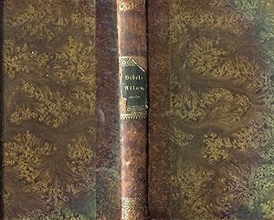
Bibel-Atlas nach den neuesten und besten H�lfsmitteln gezeichnet. Erl�utert von C. Ackermann. 3. Ausgabe.
Published by Weimar, Landes-Industrie-Comptoir., 1855
Seller: Manfred Nosbuesch, Kuchenheim, Germany
Seller Rating:

4to. V, 147 S. Mit gest. Titelvignette und 12 teilkolorierten gest. Karten. Halblederband der Zeit. Einband berieben, R�cken mit kleiner Fehlstelle. Text durchgehend etwas gebr�unt und teils fleckig, die Karten sauber.
-
Karte von Deutschland [1860]
Published by Weimar: Verlag des geographischen Instituts 1860, 1860
A folding engraved map of "Germany" (including Austria, Bohemia and Moravia) in 1860; cloth cover, map backed with cloth; unfolded: 50 x 56, folded: 9 x 15, cover worn and faded, with traces of paper label, cloth has smudges (fingerprints, traces of dust) and pale water stains, map yellowed, with slightly darker spots (traces of moisture?), edges worn, condition: good Book Language/s: German.
-
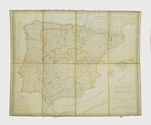
Spanien und Portugal.
Published by Weimar, Verlag des Geograph. Instituts, 1830., 1830
Seller: Versandantiquariat Wolfgang Friebes, Graz, Austria
Seller Rating:
Condition: 0. Gebr�unt u. etw. fleckig. Zwei Segmente mit jeweils einer ca. 3 cm langen Wurmspur. ge Gewicht in Gramm: 350 Grenzkolor. Kupferstichkarte, in 8 Segmenten auf Lwd. aufgezogen (ca. 47 x 59 cm).
-
Convoluut met stellingen van bovengenoemden. - Karton.
-
8�, Halbleinenband (Deckel verknickt). Etwas stock- und fingerfleckig. Mit einem kleinen Plan von Weimar. Gesamtgr��e 52 x 66 cm. [SW-Sachsen].
-
Grenzkol. Karte. Gr��e ca. 55,5 x 70 cm. -Am Rande etw. stockfl und gebr�unt, gefaltet. 1000 gr.
-
Die Herzogth�mer Schleswig, Holstein und Lauenburg. Red. v. H. Kiepert, berichtigt von C. Ohmann. Kolor. Karte (Kupfer- oder Stahlstich)
Published by Geographisches Institut, Weimar,, 1847
Seller: Antiquariat Winfried Scholl (VDA/ILAB), Osnabr�ck, Germany
Seller Rating:
ca. 60 x 49 cm. Mehrfach gefaltet. - Kleine Ausbr�che in den Knickstellen.
-
Das nordwestliche Africa. Karte aus: Grosser Hand-Atlas des Himmels und der Erde.
Published by Weimar, Geographisches Institut 1876. 45. Aufl.
Condition: -. Orig.-Kupferstichkarte mit Grenzkolorit. Bearb. von C. Gr�f. Ma�stab 1:8000000. Blattgr��e: Ca. 70 x 60 cm. Mittelfalz sowie Faltspur im Oberrand.
-
Das K�nigreich W�rtemberg, das Grossherzogthum Baden und die L�nder der F�rsten von Hohenzollern. - Grenzkolorierte, lithographische, auf Leinen aufgezogene Faltkarte in marmorierter Tasche.
Published by Geographisches Institut, Weimar, 1841
Map
Kein Einband. Condition: Gut. Grenzkolorierte, lithographische, auf Leinen aufgezogene Faltkarte im Format 61x52 cm, in marmorierter Tasche.
-
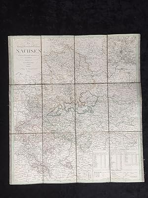
Das K�nigreich SACHSEN entworfen und gezeichnet von C.F. Weiland.
Published by Weimar, Geogr. Institut, 1832., 1832
Leinenverst�rkte Faltkarte 64 x 48 cm, kolorierter Stich von C. Poppey, kleine Karten von Dresden und der S�chs. Schweiz beigef�gt (vom s�dwestlichsten Teil Papier abgel�ste Fehlstelle, Titelabschnitt etwas fleckig) 300 gr. Buch.
-
Karl Ferdinand Weiland (1782 - 1847) war wissenschaftlicher Kartograph am Geographischen Institut in Weimar ( Bonacker S.235 ). Bei Interesse senden wir Ihnen gerne Bilder dieses Titels per E-Mail. Sprache: Deutsch Gewicht in Gramm: 0.
-
Hardcover. Condition: Ausreichend. entworfen und gezeichnet von C. F. Weiland, Weimar im Verlage des Geogr. Instituts 1857 (illustrator). Karte in Halbleinen-Pappband. 8� Einband besto�en und schmutzig. Mehrfach gestempelt. Karte mit wenigen kleineren Rissen.
-
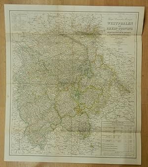
Die K�nigl. Preussischen Provinzen Westphalen und Rhein-Provinz nebst dem Kurf�rstenthum Hessen, Grossherzogthum Hessen, Herzogthum Nassau, F�rstenthum Waldeck und dem Gebiete der freien Stadt Frankfurt entworfen und gezeichnet von C. F. Weiland. Gestochen von C. Jungmann. Grenzkolorierte orig. Kupferstich aus dem Allgemeinen Hand-Atlas, genannt Weimar-Atlas.
Published by Weimar: Geographisches Institut, 1847
Map
Farbige Faltkarte mit Titelkartusche und zwei Legenden. Blattgr��e ca. 65 x 56 cm (mehrfach gefaltet, ein kleiner Fleck im wei�en Rand links, verso Reste eines Heftstreifens und leicht angeschmutzt, sonst gutes und sauberes Exemplar). Vgl. Espenhorst, PP 1.1.3. - Eine Abbildung mit h�herer Aufl�sung finden Sie auf meiner eigenen Internetseite, oder auf Anfrage. / You will find a picture with higher resolution on my own homepage or on demand. 850 gr.
-
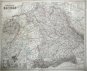
Das K�nigreich Bayern. Maa�stab 1:850000. Gesamtkarte. mehrfarbig grenzkolorierter Kupferstich, aus Hand - Atlas der Erde und des Himmels in f�nfzig Bl�ttern. Zweiundvierzigste (42) Auflage
Published by Geographisches Institut, Weimar, 1867
Seller: Buecherstube Eilert, Versandantiquariat, Kornwestheim, LB, Germany
Seller Rating:

Kupferstich Karte ca. 59 x 48 cm Fl�che, auf Blatt ca. 69 x 58 cm, Mittelfalte, Rand und R�ckseite fleckig,sonst guter Zustand. . Sprache: de.
-
Bibel-Atlas nach den neuesten und besten H�lfsmitteln gezeichnet von C. F. Weiland, und erl�utert von C. Ackermann. Zeite, umgearbeitet und vermehrte Auflage
Published by Weimar, Industrie-Comptoires 1845, 1845
Seller: Versandantiquariat Brigitte Schulz, Frankfurt am Main, Germany
Seller Rating:
Book
Hardcover. Condition: Befriedigend. 23 x 19 cm, 147 Seiten, nachgeschaltete Karten, jeder gedruckten Seite gegen�ber ist eine leere Seite f�r Notizen, s.a. Abb. - Intern: AMA befriedigendes Exemplar Sprache: deu 1300 gr.
-
Bibel-Atlas, nach den neuesten und besten H�lfsmitteln gezeichnet von C. F. Weiland und erl�utert von C. Ackermann
Published by Weimar, Verlag des Landes-Industrie-Comptoirs, 1855
Book
3. unver�nderte Auflage. 147 S. + geographische Karten Halbledereinband der Zeit; Frakturschrift, Einband Ecken und Kanten besto�en, Buchr�cken ist zum Teile die oberste Material- Schicht gebrochen, der untere Buchr�cken ist ca. 1 cm eingerissen, Fl�che berieben; Karten mit Randl�suren, Tr�gerpapiere f�r Karten teilweise mit kleinen Einrissen Sprache: Deutsch Gewicht in Gramm: 490 22 cm, Hardcover/Pappeinband; Halbleder.
-

Charte von dem Grossherz�glichen und herzoglich S�chsischen L�ndern nebst den Besitzungen den F�rsten von Schwarzenburg und Reuss, entworfen nach den neuesten Territorial Ver�nderungen.
Published by Prag, o. Vlg. 1832., 1832
Altkolorierte Kupferstichkarte. 42, 5 x 48, 8 cm (Blattgr.); 35 x 41 cm (Plattengr.) Mit dezenten Faltspuren. Leicht gebr�unt, rechter Rand mit gebr�unten Falzresten. vgl. Espenhorst 1.1.2 - Karte von Sachsen mit Titelkartusche, 2 Legenden und 1 kl. Nebenkarte von St. Wedel. Wohl Prager Nachdruck von Weilands Karte aus dem Geographischen Institut Weimar. Gewicht in Gramm: 500.
-
Deutschland. Entworfen und gezeichnet von C.F. Weiland.
Published by Weimar Verlag des geographischen Instituts oJ (), 1845
Condition: guter Zustand. Stahlstich, grenzkolorierte Karte, mit Mittelfalz, Ma�e: 56,0 x 50,0x cm, altersgem��e Gebrauchsspuren, Karte am Rand leicht eingerissen, Karte leicht angeschmutzt,
-
Condition: guter Zustand. Stich, grenzkolorierte Karte, mit Mittelfalz, gut erhalten, Karte leicht angeschmutzt, mit Randl�suren, Ma�e: 47 x 67 cm.
-
Ca. 55 x 62 cm in 12 Segmenten auf Leinwand in Schuber. Sprache: Deutsch.
-
Spanien und Portugal
Published by Geographischen Jnstituts, Weimar, 1835
Seller: BACCHETTA GIORGIO - ALFEA RARE BOOKS, Milano, Italy
Seller Rating:
Volume: 1 60x74 cm., su carta forte, a colori, in tedesco, con 4 scacchi agli angoli, raffiguranti mappa di Gibbaltar, dati su Spanien e Portugal, Lissabon, buone condizioni.
-

Bibel-Atlas nach den neuesten und besten H�lfsmitteln
Book
3. unver�nderte Aufl., Verl. des Landes-Industrie-Comptoirs, 1855. V, 147 S. mit einer gestochenen Titelvignette (Ansicht von Jerusalem) sowie 12 kolorierte Karten in Stahlstich, Leineneinband mit goldgepr�gtem R�ckentitel, (etwas berieben/ Stempel auf Vorsatz und Titel/ gering fleckig)---Verlag: Verl. des Landes-Industrie-Comptoirs Verlag: Verl. des Landes-Industrie-Comptoirs - erl�utert von C. Ackermann - 436 Gramm.
-
Bibel-Atlas, nach den neuesten und besten H�lfsmitteln gezeichnet von C. F. Weiland und erl�utert von C. Ackermann
Published by Weimar, Verlag des Landes-Industrie-Comptoirs,, 1855
Book
Couverture rigide. Condition: Assez bon. 3�me �dition. Dritte unver�nderte Auflage. Halbledereinband der Zeit, R�cken oberfl�chlich stark berieben; Bibliothek Aufkleber an R�cken und Vorsatz; Sicht von Jerusalem als Vignette auf Titelseite; 147 S. durchgehend ziemlich gebr�unt, die 13 geographische Karten am Ende weniger;
-
Ca. 50 x 66 cm in 12 Segmenten auf Leinwand in Schuber. Sprache: Deutsch.
-
Karte von Sachsen: Die K�nigl. Preussische Provinz Sachsen nebst den Herzogl. Anhaltischen L�ndern.
Published by Weimar, Geographisches Institut 1828.
Condition: -. Grenzkolorierte, auf Leinen aufgezogene Kupferstichkarte in der Gr��e (inkl. Zierrand) von 54 x 48 cm.
-
General Karte von dem Preussischen Staate entworfen und gezeichnet [Map of Prussia]
Published by Published by Geograph Instituts, Weimar, 1839
Map First Edition
, linen backed partially handcoloured map of Prussia, in German First Edition , tear to one area of map affecting the last letter of "Ost See", foxing to map and backing, small holes at some folds in the linen, handwritten title to rear, good condition , linen backed map , 16.5 x 11 cm (folded), 48 x 86 cm (open) Paperback ISBN:

![Seller image for Karte von Deutschland [1860] for sale by Antikvariat Valentinska](https://pictures.abebooks.com/inventory/md/md31778980858.jpg)

![Seller image for General Karte von dem Preussischen Staate entworfen und gezeichnet [Map of Prussia] for sale by Keoghs Books](https://pictures.abebooks.com/inventory/md/md22845782094.jpg)