Order Total (1 Item Items):
Shipping Destination:

Streit, F W (26 results)
Skip to main search results
Product Type
- All Product Types
- Books (16)
- Magazines & Periodicals
- Comics
- Sheet Music
- Art, Prints & Posters
- Photographs
- Maps (10)
-
Manuscripts &
Paper Collectibles
Condition
Binding
Collectible Attributes
Seller Location
Seller Rating
-

European Capital Markets
Published by Palgrave Macmillan, 2000
ISBN 10: 0333924363ISBN 13: 9780333924365
Seller: Wonder Book, Frederick, MD, U.S.A.
Seller Rating:

Book
Condition: As New. Like New condition. Very Good dust jacket. A near perfect copy that may have very minor cosmetic defects.
More buying choices from other sellers on AbeBooks
New offers from � 87.86
Used offers from � 5.40
Also find Hardcover
-
Historischer und Geographischer Atlas von Europa, Vol. 1 (Classic Reprint)
Published by Forgotten Books, 2020
ISBN 10: 0666037485ISBN 13: 9780666037480
Book Print on Demand
Paperback. Condition: New. Print on Demand. Excerpt from Historischer und Geographischer Atlas von Europa. About the Publisher, Forgotten Books publishes hundreds of thousands of rare and classic books. This book is a reproduction of an important historical work. Forgotten Books uses state-of-the-art technology to digitally reconstruct the work, preserving the original format whilst repairing imperfections present in the aged copy. In rare cases, an imperfection in the original, such as a blemish or missing page, may be replicated in our edition. We do, however, repair the vast majority of imperfections successfully; any imperfections that remain are intentionally left to preserve the state of such historical works. This text has been digitally restored from a historical edition. Some errors may persist, however we consider it worth publishing due to the work's historical value. The digital edition of all books may be viewed on our website before purchase. print-on-demand item.
-

Historischer und geographischer Atlas vin Europa ( keine landkarten )
Published by W. Natorff und Comp. Verlag, 1837
Condition: Orig. halbledereinband. 8° 1 735 S. Ecken und Kanten besto� en.
-
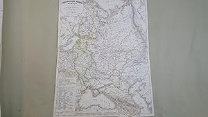
Map of Das Russische Reich in Europa
Published by Published by J.C. Hinrichs'sche Buchhandlung, Leipzig, 1840
Map First Edition
, 47.5 x 36 cm engraved map with hand coloured political boundaries, double page plate on guard mount with margins cropped, text in German First Edition thus , a few faint brown spots, otherwise map in very good condition 47.5 x 36 cm Map ISBN:
-

Map of Frankreich
Published by Published by J.C. Hinrichs'sche Buchhandlung, Leipzig, 1840
Map First Edition
, 39 x 47.5 cm engraved map with hand coloured political boundaries, Inset map of Corsica, double page plate on guard mount with margins cropped, text in German First Edition thus , a few brown spots near bottom edges, otherwise map in very good condition 39 x 47.5 cm Map ISBN:
-
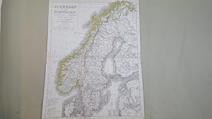
Map of Schweden und Norwegen
Published by Published by J.C. Hinrichs'sche Buchhandlung, Leipzig, 1840
Map First Edition
, 51 x 38 cm engraved map with hand coloured political boundaries, double page plate on guard mount, text in German First Edition thus , a few faint brown spots, ink spot to upper marginotherwise map in very good condition 51 x 38 cm Map ISBN:
-
Charte vom Preussischen Staate, oder Gebirgs- und Fluss-Charte des n�rdlichen Teutschlands, neu entworfen und gezeichnet von F. W. Streit. Vermehrt und berichtigt bis zum Jahre 1832. Gestochen von H. Leutemann
Published by Leipzig, J. C. Hinrichssche Buchhandlung, 1832
Map
63 x 44cm. Condition: Gut. 1 Blatt mehrfach gefaltete, farbige Karte, altersbedingt leicht fleckig, keine Einrisse, sehr seltene und erstaunlich gut erhaltene Karte, gutes Sammlerst�ck Wir senden umgehend mit beiliegender MwSt.Rechnung. Sprache: Deutsch Gewicht in Gramm: 150.
-
(Hrsg.) Historischer und geographischer Atlas von Europa. 2 Bde. (in 3). Bln., Natorff 1834-37. 1 Bl., 1009 S., 1 Bl.; 664 S.; 2 Bl. 735 S. HLdr. d. Zt. (berieben, Ecken leicht besto�en, R�cken mit kleinen Einrissen an den Kapitalen und am Au�engelenk).- Bd. II,1: 2 Blatt (Titel und Inhaltsverzeichnis) fehlen.- Vors�tze etwas fleckig, Besitzvermerk auf Vorsatz, etwas eng gebunden, Bd. II: Titel mit kleinem Eckabri�, einige Seiten etwas stockfleckig.
-
Wolfenb�ttel; Melchior Verlag, 2006, Quer-4�, Titelblatt, Vorwort und 30 farbige -Karten-Tafeln, Original-Pappeinband in sch�ner Erhaltung.
-
CHARTE VON FRANKREICH. . Map of France.
Published by Friedrich Wilhelm Streit for Verlag des Geograph. Instituts Weimar 1817, 1817
Map
48x58cm. Original outline colour. Excellent condition.
-
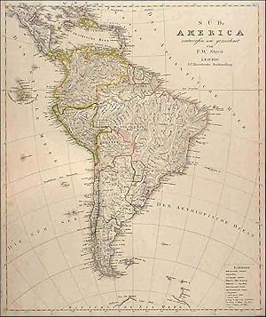
S�D-AMERICA. . Nice map of South America including the Schildkroten or Gallapagos Islands. The tip of the South Polar region is included at the bottom of the engraving.
Published by F. W. Streit in Leipzig ca. 1830, 1830
Map
47x39cm. Original outline Colour. Uncommon.
-

CHARTE VON DEM K�NIGREICHE W�RTTEMBERG UND DEM GROSHERZOGTHUME BADEN . Map of Baden-W�rttemberg, designed by F. W. Streit and published by
Published by Verlag des Geograph. Instituts Weimar 1818, 1818
Map
53x49cm. Original outline colour. Excellent condition.
-
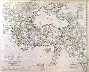
CHARTE DES OSMANISCHEN REICHS IN EUROPA U. ASIEN. . Turkey in Europe and Asia. - together with a double sided page if explanation.
Published by F. W. Streit in Leipzig ca. 1830, 1830
Map
39x48cm. Original outline Colour. small tears at top of map repaired and two very small ink marks - otherwise good.
-
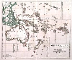
AUSTRALIEN NACH DEN NEUESTEN H�LFSMITTELN ENTWORFEN . Australia, New Zealand and Polynesia, reaching to Hawaii. Drawn by Arno Streit after
Published by Friedrich Wilhelm Streit 1834, 1834
Map
38x45cm. Original outline colour. Excellent condition.
-
0. 3 B�nde. 8� 1009/664/735 Seiten Halbledereinband der Zeit. Einband mit Goldpr�g., 3seitiger Gr�nschnitt, marmorierte Deckel, Einband berieben und bestossen, kleiner Stempel, Seiten leicht fleckig. Sprache: Deutschutsch 2,300 gr.
-
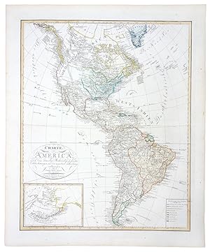
Charte von America (1810)
Publication Date: 1810
Map
No Binding. Condition: As New. 55 x 67 cm.
-
0. 33 x 26,5 cm. 82 Bl. �berwiegend Kt.m. Grenzkolorit. Complete with engraved title page an 82 copper engravings . Halbleder, Deckeltitel, Kanten berieb.+bestoss., Karten tls. gebr�nt o. stockfl., insgesamt gut erh., Sprache: Deutschu 2,000 gr.
-
Mit gestochenem Titel, 78 grenzkolorierte Kupfersticharten u. 4 gestochenen �bersichten. Quer-4�. Hldr.d.Zt. Berieben u. bestossen. Durchgehend wenig bis st�rker stockfleckig. Die "Spanien und Portugal" Karten sind numerisch falsch eingebunden. *** 40 Jahre - Heilbronner Antiquariat - Michael Wahl - 1983-2023 ***.
-
Tooley IV, 226.- Der in Wien geborene F. W. Streit (1772-1839) war Ingenieur u. Mathematiker in der preussischen Artillerie sowie v. 1807-08 Direktor des Geographischen Institutes in Weimar, f�r dessen Atlas er 6 neue Karte von Europa entwarf.- Mit einer �bersichtskarte v. Europa sowie zahlr. (tls. mehrteil.) Detailkarten; u.a. Schweiz (2), Deutschland (28), �sterreich (5), Dalmatien, B�hmen, M�hren, Siebenb�rgen, Italien (6), UK (4), Russland (4teilig), Polen (2), Skandinavien (5), T�rkei, Griechenland, Spanien u. Portugal (4teilig).- Titel mit Braunfleck, tls. etw. gebr�unt od. braunfleckig, Ebd. leicht berieben, insges. gutes, vollst�ndiges Ex.