
Order Total (1 Item Items):
Shipping Destination:

Kleinasien Anatolia Asia Minor Reichard, C G (1 results)
Skip to main search results
Product Type
- All Product Types
- Books
- Magazines & Periodicals
- Comics
- Sheet Music
- Art, Prints & Posters (1)
- Photographs
- Maps
-
Manuscripts &
Paper Collectibles
Condition
- All Conditions
- New
- Used
Binding
- All Bindings
- Hardcover
- Softcover
Collectible Attributes
- First Edition
- Signed
- Dust Jacket
- Seller-Supplied Images
- Not Printed On Demand
Seller Location
Seller Rating
-
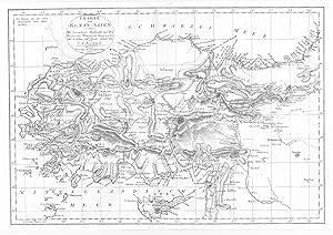
Charte von Klein-Asien. Mit besonderer Rücksicht auf Hrn. Professor Mannerts Geographie der Griechen und Römer entworfen.
Published by Weimar: Geograph. Institut dat. ,, 1805
Seller: Antiquariat Ruthild Jäger, Lueneburg, Germany
Seller Rating:

Art / Print / Poster
Kupferstich / copper engraving, 39 x 27 cm (Faltspuren geglättet, sehr gut erhalten / traces of folding, otherwise in very good condition). * Die Karte zeigt Kleinasien vom Bosporus bis Arzerum und an die Grenzen von Syrien und dem Kaukasus, im Süden bis Rakka, Latakia und Zypern reichend. Eingetragen sind die antiken und modernen Ortsnamen. * A detailed map of Anatolia, from Constantinopel to the Syrian border and Cyprus, with the antique and modern place names.