
Order Total (1 Item Items):
Shipping Destination:

Johann Baptist Homann (620 results)
Skip to main search results
Product Type
- All Product Types
- Books (242)
- Magazines & Periodicals
- Comics
- Sheet Music
- Art, Prints & Posters (57)
- Photographs
- Maps (321)
-
Manuscripts &
Paper Collectibles
Condition
Binding
Collectible Attributes
- First Edition (10)
- Signed (2)
- Dust Jacket (1)
- Seller-Supplied Images (552)
- Not Printed On Demand
Free Shipping
Seller Location
Seller Rating
-
Condition: New.
-
farbiger REPRINT Karte 50 cm x 60 cm mit Erl�uterungsbeilage in deutsch, englisch und russisch. Leichte Randl�suren.
-

Prospect und Grundris der Keiserl. Freyen Reichs- und Ansee-Stadt Hamburg. 1986 Nachfdr. d. Ausg. 1715
Published by Pf�hler, Bad Neustadt, 1986
1 Karte 57 x 48 cm gutes Exemplar.
-
Condition: New.
More buying choices from other sellers on AbeBooks
New offers from � 30.47
-
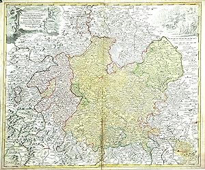
Norddeutschland : der Nieders�chsische Reichskreis. Nachdr. des Orig. nach 1714
Published by Pfaehler, Bad Neustadt, 1986
1 Karte plano 55 x 70 cm gutes Exemplar.
-
Ducatus Pomeraniae novi�ima tabula. Nachdr. d. Ausgabe von 1715.
Published by Pfaehler, Bad Neustadt, 1989
1 Karte plano 56 x 46 cm gutes Exemplar.
-
Karte des Territoriums der Hansestadt Hamburg. Nachdr. Des Originals von 1715.
Published by Pfaehler, Bad Neustadt, 1986
1 Karte plano 57 x 49 cm gutes Exemplar.
-
1 Karte plano 57 x 48 cm gutes Exemplar.
-
Orig.-Kupferstich um 1720 mit Grenz- und Fl�chenkolorit, Faltspur in der Mitte. Titelkartusche oben links. Dargestellt die Wetterau, Taunus und Rheingau. Rechts unten die Gesamtansicht von Langenschwalbach und der 'ber�hmte Sauerbrunnen von Schwalbach'. - Motiv 50 x 59 unter Passepartout und Glas mit profiliertem Echtholzrahmen 60 x 68. * Sehr gut erhalten !.
-
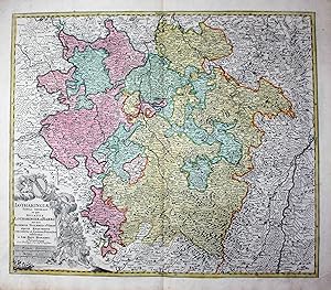
Lotharingiae Tabula Generalis in qua Ducatus Lotharingiae et Barri nec non Metensis, Tullensis et Verdunensis Episcopatus cum insertis et finitimis Ditionibus exhibentur." - Lorraine Lothringen France Frankreich carte map Karte
Published by N�rnberg um 1720., 1720
Seller: Antiquariat Steffen V�lkel GmbH, Seubersdorf, Germany
Seller Rating:

Map
Original altkolorierte Kupferstich-Karte von J. B. Homann (1664-1724) von ca. 1720. -- Blatt-Ma�e: ca. 63 x 55 cm. -- Mit Nancy, Toul, Metz, Saarbr�cken, Hagenau, Stra�burg, Verdun, Zweibr�cken. -- mit kleinem L�chlein im Mittelfalz, sonst gut erhalten. || Original old colored copper engraved map by J. B. Homann (1664-1724) from around 1720. -- Includes the cities of Nancy, Toul, Metz, Saarbr�cken, Hagenau, Stra�burg, Verdun, Zweibr�cken. -- with very small hole in the middle fold, otherwise in good condition. Sprache: Deutsch Gewicht in Gramm: 1550.
-
Bavariae Circulus et Electorat in suasquae ditiones tan cum adiacentibus quam insertis regionibus accuratisime divisus." - Bayern M�nchen Regensburg Passau N�rnberg Karte map
Published by N�rnberg, 1720
Seller: Antiquariat Steffen V�lkel GmbH, Seubersdorf, Germany
Seller Rating:
Map
Original altkolorierte Kupferstich-Karte von Johann Baptist Homann (1664-1724) von ca. 1720. -- Blatt-Ma�e: ca. 61 x 52 cm. -- etwas gebrauchspurig, etwas schwache Kolorierung, sonst gut erhalten. || Original old colored engraved map by Johann Baptist Homann (1664-1724) from c. 1720. -- with some signs of wear, slightly faded coloring, otherwise in good condition. || Dies ist ein Original! - Kein Nachdruck! - Keine Kopie! -- This is an original! No copy! - No reprint! Sprache: Deutsch Gewicht in Gramm: 1550.
-
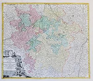
Lotharingiae Tabula Generalis in qua Ducatus Lotharingiae et Barri nec non Metensis, Tullensis et Verdunensis Episcopatus cum insertis et finitimis Ditionibus exhibentur." - Lorraine Lothringen Nancy Toul Metz Saarbr�cken Haguenau Stra�burg Verdun Zweibr�cken France Frankreich carte
Published by N�rnberg um 1720., 1720
Seller: Antiquariat Steffen V�lkel GmbH, Seubersdorf, Germany
Seller Rating:
Map
Original altkolorierte Kupferstich-Karte von J. B. Homann (1664-1724) von ca. 1720. -- Blatt-Ma�e: ca. 55 x 63 cm. -- gut erhalten. || Original old colored copper engraved map by J. B. Homann (1664-1724) from around 1720. -- Includes the cities of Nancy, Toul, Metz, Saarbr�cken, Hagenau, Stra�burg, Verdun, Zweibr�cken. -- in good condition. || Dies ist ein Original! - Kein Nachdruck! - Keine Kopie! -- This is an original! - No copy! - No reprint! la Gewicht in Gramm: 1550.
-
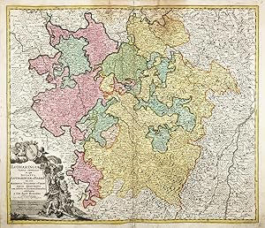
Lotharingiae Tabula Generalis in qua Ducatus Lotharingiae et Barri nec non Metensis, Tullensis et Verdunesis Episcopatus cum insertis et finitimis Ditionibus exhibentur" - Lothringen Lorraine Nancy Metz Moyenvic Colmar Strasbourg Epinal Toul Sarrebourg France carte
Published by N�rnberg um 1720., 1720
Seller: Antiquariat Steffen V�lkel GmbH, Seubersdorf, Germany
Seller Rating:
Map
Original altkolorierte Kupferstich-Karte von J. B. Homann (1664-1724) von ca. 1720. -- Blatt-Ma�e: ca. 53 x 62 cm. -- etwas fleckig, im Mittelbug hinterlegt, mit teils hinterlegten Randeinrissen, sonst gut erhalten. || Original old colored copper engraved map by J. B. Homann (1664-1724) from around 1720. -- with some staining, deposited on the centerfold, with partly deposited marginal tears, otherwise in good condition. || Dies ist ein Original! - Kein Nachdruck! - Keine Kopie! -- This is an original! - No copy! - No reprint! la.
-

Cursus Rheni a Basilea usque ad Bonnam, III. sect. exhibit. Sectio III seu Superior.: in qua sistitur maxima pars Alsatiae, Brisgoviae, una cum aliis Sueviae tractibus confinius" - Rheinlauf Rhein Strassburg Breisach Basel Freiburg Breisgau Schwarzwald
Published by N�rnberg, Homann Erben ca. 1740., 1740
Seller: Antiquariat Steffen V�lkel GmbH, Seubersdorf, Germany
Seller Rating:
Map
Original altkolorierte Kupferstich-Karte von J. B. Homann von ca. 1740. Zeigt den Rhein von Strassburg bis Waldshut-Tiengen. -- Blatt-Ma�e: ca. 52 x 61 cm. -- im Randbereich teils fleckig, sonst gut erhalten. || Original old colored engraved map by J. B. Homann from ca. 1740. -- partly stained on the margins, otherwise in good condition. || Dies ist ein Original! - Kein Nachdruck! - Keine Kopie! -- This is an original! - No copy! - No reprint! la Gewicht in Gramm: 35.
-

Lotharingiae Tabula Generalis in qua Ducatus Lotharingiae et Barri nec non Metensis, Tullensis et Verdunensis Episcopatus cum insertis et finitimis Ditionibus exhibentur." - Lorraine Lothringen Nancy Toul Metz Saarbr�cken Haguenau Stra�burg Verdun Zweibr�cken / France Frankreich
Published by N�rnberg um 1720., 1720
Seller: Antiquariat Steffen V�lkel GmbH, Seubersdorf, Germany
Seller Rating:
Map
Altkolorierte Kupferstich-Karte von J. B. Homann (1664-1724) von ca. 1720. -- Blatt-Ma�e: ca. 53 x 60 cm. -- gut erhalten. || Old colored copper engraved map by J. B. Homann (1664-1724) from around 1720. -- Includes the cities of Nancy, Toul, Metz, Saarbr�cken, Hagenau, Stra�burg, Verdun, Zweibr�cken. -- in good condition. Sprache: Deutsch Gewicht in Gramm: 35.
-
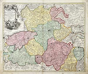
Comitatus Hannoniae" - Hainaut Hennegau Belgique Belgien Belgium Valenciennes Cambrai Maubeuge Mons Tournai Charleroi Philippeville Avesnes Douai Ath Quesnoy Bouchain Chimay Landrecies Chimay France
Published by N�rnberg um 1720., 1720
Seller: Antiquariat Steffen V�lkel GmbH, Seubersdorf, Germany
Seller Rating:
Map
Original altkolorierte Kupferstich-Karte von J. B. Homann (1664-1724) von ca. 1720. -- Blatt-Ma�e: ca. 55 x 62 cm. -- etwas fleckig, mit hinterlegtem Randeinriss, sonst gut erhalten. || Original old colored copper engraved map by J. B. Homann (1664-1724) from around 1720. -- Includes the cities of Valenciennes, Cambrai, Maubeuge, Mons, Tournai, Philippeville, Aresnes. -- somewhat stained, with deposited marginal tear, otherwise in good condition. Sprache: Deutsch Gewicht in Gramm: 35.
-
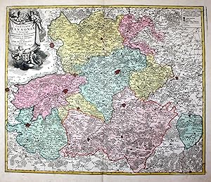
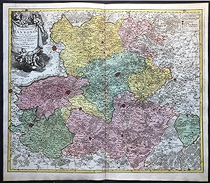
(N�rnberg: Joh. Bapt. Homann, o. J. ca. 1720). Doppelblattgrosser, teils grenz- u. fl�chenkolorierter Orig.-Kupferstich-Karte des zentralen Nordeutschlands. Sie reicht im Nordwesten von der Elbm�ndung bis zur Insel R�gen im Nordosten und im S�dwesten von Lippe bis Berlin im S�dosten. Die Homann-Karte ist mittig gefaltet und in Herzogt�mer eingeteilt; von alter Hand wurde einige gr��ere S�dtenamen schwach unterstrichen. Die allegorische Titelkartusche ist nicht koloriert und enth�lt einen Meilenanzeiger. - Kartenma�: 47,5 x 56,5 auf einem Blatt von 52,5 x 61 unter Glas in einem profilierten Holzrahmen. * Wohlerhaltene Niedersachen-Karte, n�rdlich begrenzt durch das "Teutsche" und das "Balthische Meer". - Large map of Lower Saxonia divided up into its duchies and bishoprics. The map extends from Hamburg with the river Elbe towards the Baltic Sea with the island of Ruegen in the east. At the bottom an allegoric title cartouche. - Die dunkelrote Farbe des Bilderrahmens an vielen Stellen abgebl�ttert. - Versand nur mit Paket-Porto !.
-
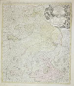
No Binding. Condition: Good. HESSEN GERMANY. HOMANN. C1715 ----TITLE: Landgraviatus Hassi� Inferioris nova Tabula, in qua pr�cique Ditiones Hasso-Casselense et Comitatus Waldeck cum insertis et vicinis alioru Statuum Pr�fecturis exhibentur. ----DESCRIPTION: This is a very detailed map of Lower Hessen with its individual duchies and territories showing place names, rivers, woods and mountains. Cassell (Kassel) is at the center of the map. ----IMPRINT: a Ioh. Bapt. Homanno Noriberg�. 19 h x 22 � w. Copper engraving. The verso is blank except for the words Kur-Hessen in bold manuscript. The term "S.C.M. Geogr." or Sacrae Caesareae Majestatis Geographus (Geographer of the Holy Imperial Majesty) does not appear in the title or imprint, suggesting this map was engraved prior to 1715 when Homann received that title and began to add that important title to his works. ----CARTOUCHES: The title cartouche is at the upper left. A forest scene with hunters is at the upper right. Neither cartouche is colored as was the general practice for original coloring of Homann maps. The map is by Johann Baptist Homann (1664-1724), a German engraver and publisher in Nuremberg. ----CONDITION: Old repair with paper to lower centerfold. Margins soiled and stained. Original hand-outline and wash color. Image in good condition. ----Z7M32.
-
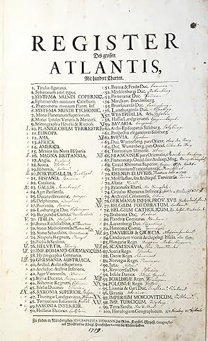
Register des Gro�en Atlantis. Mit hundert Charten.
Published by N�rnberg: Homann ,, 1719
Seller: Antiquariat Ruthild J�ger, Lueneburg, Germany
Seller Rating:

(Folio). 1 Blatt (31 x53 cm) (minimale Randeinrisse sorgf�ltig unterlegt, sonst sehr gut erhalten; small tears in the margins repaired, otherwise in good condition).
-
Comitatus Hannoniae" - Hainaut Hennegau Belgique Belgien Belgium France carte map Karte
Published by N�rnberg um 1720., 1720
Seller: Antiquariat Steffen V�lkel GmbH, Seubersdorf, Germany
Seller Rating:
Map
Original altkolorierte Kupferstich-Karte von J. B. Homann (1664-1724) von ca. 1720. -- Blatt-Ma�e: ca. 63 x 55 cm. -- Mit Valenciennes, Cambrai, Maubeuge, Mons, Tournai, Charleroi, Philippeville, Avesnes, Douai, Ath, Quesnoy. -- gut erhalten. || Original old colored copper engraved map by J. B. Homann (1664-1724) from around 1720. -- Includes the cities of Valenciennes, Cambrai, Maubeuge, Mons, Tournai, Philippeville, Aresnes. -- in good condition. Sprache: Deutsch Gewicht in Gramm: 1550.
-
Comitatus Hannoniae" - Hainaut Hennegau Belgique Belgien Belgium Valenciennes Cambrai Maubeuge Mons Tournai Charleroi Philippeville Avesnes Douai Ath Quesnoy Bouchain Chimay Landrecies Chimay France carte map Karte
Published by N�rnberg um 1720., 1720
Seller: Antiquariat Steffen V�lkel GmbH, Seubersdorf, Germany
Seller Rating:
Map
Original altkolorierte Kupferstich-Karte von J. B. Homann (1664-1724) von ca. 1720. -- Blatt-Ma�e: ca. 60 x 52 cm. -- teils leicht fleckig, sonst gut erhalten. || Original old colored copper engraved map by J. B. Homann (1664-1724) from around 1720. -- Includes the cities of Valenciennes, Cambrai, Maubeuge, Mons, Tournai, Philippeville, Aresnes. -- partly slightly stained, otherwise in good condition. || Dies ist ein Original! - Kein Nachdruck! - Keine Kopie! -- This is an original! - No copy! - No reprint! Sprache: Deutsch Gewicht in Gramm: 1550.
-
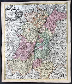
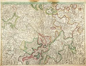
Landgraviatus Alsatiae tam Superioris quam Inferi(oris) cum utroque Marchionatu Badensi ut et tractu Herciniae Silvae." - Elsass Alsace Strasbourg Colmar Ensisheim Freiburg Breisgau Dambach Rhein Rhine riviere river Fluss gravure carte Karte map
Published by N�rnberg, 1720
Seller: Antiquariat Steffen V�lkel GmbH, Seubersdorf, Germany
Seller Rating:
Map
original kolorierte Kupferstich-Karte von ca. 1720 - Blatt-Format: ca. 60 x 52 cm - gut erhalten. | original colored copper engraved map from about 1720 - in good condition. | Original! - Kein Nachdruck! - Keine Kopie! | This is an original! - No reprint! - No copy! Sprache: Deutsch Gewicht in Gramm: 1500.
-
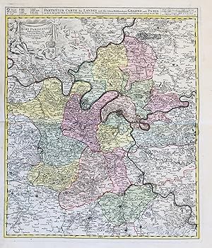
Agri Parisiensis Tabula particularis, qua maxima Pars Insulae Franciae, seu Regiae celeberrimaeq. Parisiorum Urbis vicina Regia in suas Castellanias accurate di visa exhibetur. / Particulir Carte des Landes und der Sch�n-Weltber�hmte Gegend um Paris so da ist der gr��te Theil des Gouvernem. der Insul von Franckreich, accurat verzeichnet von F. Vivier und verlegt durch JBH" - Paris Corbeil Etampes Versailles Ile-de-France carte map Karte
Published by N�rnberg, Homann Erben ca. 1720., 1720
Seller: Antiquariat Steffen V�lkel GmbH, Seubersdorf, Germany
Seller Rating:
Map
Original altkolorierte Kupferstich-Karte von ca.1720. -- Blatt-Ma�e: ca. 63 x 55 cm. -- im Mittelbug leicht eingerissen, sonst sehr gut erhalten. || Original old colored engraved map from c. 1720. -- slightly split on the centerfold, otherwise in very good condition. || Dies ist ein Original! - Kein Nachdruck! - Keine Kopie! -- This is an original! No copy! - No reprint! la Gewicht in Gramm: 1550.
-
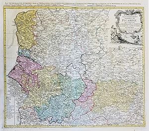
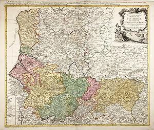
Carte du Gouvernement General de Picardie qui comprend le Generalite d'Amiens avec l'Artois & les Frontieres des Pays Bas" - Picardie Abbeville Amiens Corbie Arras Bapaume Lille Guise Moncornet Valenciennes Maubeuge Lens France Frankreich Carte
Published by N�rnberg, Homann Erben, 1746
Seller: Antiquariat Steffen V�lkel GmbH, Seubersdorf, Germany
Seller Rating:
Map
Sehr dekorativehandkolorierte Kupferstich-Karte vonJohann Baptist Homann von 1746. -- Blatt-Format: ca.55 x63 cm. - J.B. Homann war einer der bedeutendsten Kartenmacher des 18. Jahrhunderts. - leicht gebr�unt - sonst gut erhalten. / Very good condition. || Dies ist ein Original! - Kein Nachdruck! - Keine Kopie! -- This is an original! - No copy! - No reprint! Sprache: Franz�sisch.
-
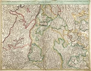
Cursus Rheni a Basilea usque ad Bonnam, III. sect. exhibit. Sectio III seu Superior.: in qua sistitur maxima pars Alsatiae, Brisgoviae, una cum aliis Sueviae tractibus confinius" - Rheinlauf Rhein Strassburg Breisach Basel Freiburg Breisgau Schwarzwald
Published by N�rnberg, Homann Erben ca. 1740., 1740
Seller: Antiquariat Steffen V�lkel GmbH, Seubersdorf, Germany
Seller Rating:
Map
Original altkolorierte Kupferstich-Karte von J. B. Homann von ca. 1740. Zeigt den Rhein von Strassburg bis Waldshut-Tiengen. -- Blatt-Ma�e: ca. 52 x 61 cm. -- im oberen Au�enrand etwas fleckig, sonst gut erhalten. || Original old colored engraved map by J. B. Homann from ca. 1740. -- with some staining on the upper outer margin, otherwise in good condition. || Dies ist ein Original! - Kein Nachdruck! - Keine Kopie! -- This is an original! - No copy! - No reprint! la.
-
Cursus Rheni � Basilea usque ad Bonnam III. Sect.Sectio II. seu Media, quae continet part. Elect. Palat. Duc. Bipont. Alsatiae Infer. Comit. Rhingraf. Duc. W�rtemb. March. Badens." - Rheinlauf Rhein Baden-W�rttemberg Worms Mannheim Speyer Heidelberg Homburg Karlsruhe Strassburg Pforzheim
Published by N�rnberg, Homann Erben ca. 1740., 1740
Seller: Antiquariat Steffen V�lkel GmbH, Seubersdorf, Germany
Seller Rating:
Map
Original altkolorierte Kupferstich-Karte von J. B. Homann von ca. 1740. Zeigt den Rhein von Worms bis Strassburg. -- Blatt-Ma�e: ca. 52 x 61 cm. -- im oberen Rand etwas braunfleckig, sonst gut erhalten. || Original old colored engraved map by J. B. Homann from ca. 1740. -- with some brownstaining on the upper margin, otherwise in good condition. || Dies ist ein Original! - Kein Nachdruck! - Keine Kopie! -- This is an original! - No copy! - No reprint! la Gewicht in Gramm: 35.
-
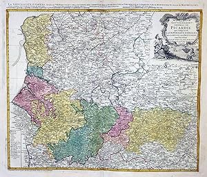
Carte du Gouvernement General de Picardie qui comprend le Generalite d'Amiens avec l'Artois & les Frontieres des Pays Bas" - Picardie Abbeville Amiens Corbie Arras Bapaume Lille Guise Moncornet Valenciennes Maubeuge Lens France Frankreich
Published by N�rnberg, Homann Erben, 1746
Seller: Antiquariat Steffen V�lkel GmbH, Seubersdorf, Germany
Seller Rating:
Map
Sehr dekorativehandkolorierte Kupferstich-Karte vonJohann Baptist Homann von 1746. -- Blatt-Format: ca.52 x61 cm. - J.B. Homann war einer der bedeutendsten Kartenmacher des 18. Jahrhunderts. - teils leicht fleckig, sonst gut erhalten. || Dies ist ein Original! - Kein Nachdruck! - Keine Kopie! -- This is an original! - No copy! - No reprint! Sprache: Franz�sisch.
-
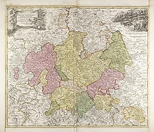
Landgraviatus Hassiae Inferioris nova Tabula, in qua praecipue Ditiones Hasso-Casselense et Comitatus Waldeck cum insertis et vicinis alioru Statuum Praefecturis exhibentur" - Hessen Kassel H�xter Paderborn Schmalkalden Bad Hersfeld Hann. M�nden G�ttingen Baunatal Fritzlar Karte map
Published by N�rnberg ca. 1720., 1720
Seller: Antiquariat Steffen V�lkel GmbH, Seubersdorf, Germany
Seller Rating:
Map
Original altkolorierte Kupferstich-Karte von ca. 1720. Blatt-Ma�e: ca. 56 x 65 cm. -- Knapp beschnitten, ringsherum alt anger�ndert; sonst gut erhalten. || Original old colored engraved map from ca. 1720. -- Narrowly trimmed, backed on all margins; otherwise in good condition. || Dies ist ein Original! - Kein Nachdruck! - Keine Kopie! -- This is an original! - No copy! - No reprint! la Gewicht in Gramm: 15.
-
Carte du Gouvernement General de Picardie qui comprend le Generalite d'Amiens avec l'Artois & les Frontieres des Pays Bas" - Picardie Abbeville Amiens Corbie Arras Bapaume Lille Guise Moncornet Valenciennes Maubeuge Lens France Frankreich
Published by N�rnberg, Homann Erben, 1746
Seller: Antiquariat Steffen V�lkel GmbH, Seubersdorf, Germany
Seller Rating:
Map
Sehr dekorativehandkolorierte Kupferstich-Karte vonJohann Baptist Homann von 1746. -- Blatt-Ma�e: ca. 54,5 x 65 cm. . - J.B. Homann war einer der bedeutendsten Kartenmacher des 18. Jahrhunderts. - gut erhalten. || Dies ist ein Original! - Kein Nachdruck! - Keine Kopie! -- This is an original! - No copy! - No reprint! Sprache: Franz�sisch Gewicht in Gramm: 30.
-
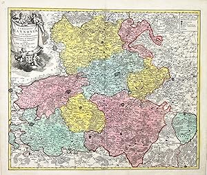
Comitatus Hannoniae" - Hainaut Hennegau Belgique Belgien Belgium Valenciennes Cambrai Maubeuge Mons Tournai Charleroi Philippeville Avesnes Douai Ath Quesnoy Bouchain Chimay Landrecies Chimay France
Published by N�rnberg um 1720., 1720
Seller: Antiquariat Steffen V�lkel GmbH, Seubersdorf, Germany
Seller Rating:
Map
Original altkolorierte Kupferstich-Karte von J. B. Homann (1664-1724) von ca. 1720. -- Blatt-Ma�e: ca. 55 x 62 cm. -- gut erhalten. || Original old colored copper engraved map by J. B. Homann (1664-1724) from around 1720. -- Includes the cities of Valenciennes, Cambrai, Maubeuge, Mons, Tournai, Philippeville, Aresnes. -- in good condition. Sprache: Deutsch Gewicht in Gramm: 35.
