Order Total (1 Item Items):
Shipping Destination:

Homann Erben (187 results)
Skip to main search results
Product Type
- All Product Types
- Books (127)
- Magazines & Periodicals
- Comics
- Sheet Music
- Art, Prints & Posters (18)
- Photographs
- Maps (42)
-
Manuscripts &
Paper Collectibles
Condition
Binding
Collectible Attributes
- First Edition (1)
- Signed
- Dust Jacket
- Seller-Supplied Images (165)
- Not Printed On Demand (186)
Free Shipping
Seller Location
Seller Rating
-
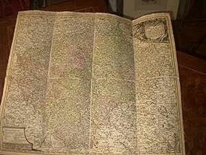
![Seller image for Regni Bohemiae, Circulus . : ex M�llerianis aliisque recentissimis subsidiis chorographice designatus ut et secundum statum politicum modernum expressus [LeatherBound] for sale by True World of Books](https://pictures.abebooks.com/inventory/md/md31532993277.jpg)
LeatherBound. Condition: New. Leather Binding on Spine and Corners with Golden leaf printing on spine. Bound in genuine leather with Satin ribbon page markers and Spine with raised gilt bands. A perfect gift for your loved ones. Reprinted from 1769 edition. NO changes have been made to the original text. This is NOT a retyped or an ocr'd reprint. Illustrations, Index, if any, are included in black and white. Each page is checked manually before printing. As this print on demand book is reprinted from a very old book, there could be some missing or flawed pages, but we always try to make the book as complete as possible. Fold-outs, if any, are not part of the book. If the original book was published in multiple volumes then this reprint is of only one volume, not the whole set and contains approximately 18 pages. IF YOU WISH TO ORDER PARTICULAR VOLUME OR ALL THE VOLUMES YOU CAN CONTACT US. Resized as per current standards. Sewing binding for longer life, where the book block is actually sewn (smythe sewn/section sewn) with thread before binding which results in a more durable type of binding. Language: Latin.
-
Map. Condition: Brand New. German language. 25.00x2.13x2.13 inches. In Stock.
-
Map. Condition: Brand New. German language. 24.80x2.05x2.05 inches. In Stock.
-
Map. Condition: Brand New. German language. 24.80x2.09x2.09 inches. In Stock.
-
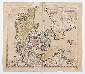
General Charte vom Konigreich Daenemark.
Published by Nuremberg, 1789
Seller: Robert Frew Ltd. ABA ILAB, London, United Kingdom
Association Member: ABA ILAB PBFA
Seller Rating:

Map
48 x 55 cm. Double page engraved map with original colour Some dampstaining.
-

Cursus Rheni a Basilea usque ad Bonnam III Sectionibus exhibitus a Domino G. de l'Isle, . nunc multis modis auctior et emendatior redditus. Sectio I. seu Inferior." - Rhein Rheinlauf Bonn Worms Mainz Rheinfels Darmstadt Koblenz Bingen
Published by N�rnberg um 1740., 1740
Seller: Antiquariat Steffen V�lkel GmbH, Seubersdorf, Germany
Seller Rating:
Map
Original altkolorierte Kupferstich-Karte von ca. 1740. Zeigt den Rheinlauf von Bonn bis Worms. -- Blatt-Ma�e: ca. 52 x 61 cm. -- oben teils etwas braunfleckig, sonst gut erhalten. || Original old colored copper engraved map from around 1740. -- with some staining on the upper part, otherwise in good condition. || Dies ist ein Original! - Kein Nachdruck! - Keine Kopie! -- This is an original! - No copy! - No reprint! la.
-

Vorstellungen der Grundrisse.
Published by Homann Erb, N�rnberg, 1745
Art / Print / Poster
49,5 x 37 cm. 53,5 x 41 cm. Condition: Gut. Kol.Kupf. Homann Homan Erben. Tabelle der gr��ten St�dte im Altertum nud der Neuzeit. Verfertigit von Joh.Matth.Hassius, Mattem. Prof. Tadellos erhalten. deu S 1|45BG Sprache: Deutsch Gewicht in Gramm: 444.
-
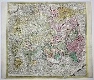
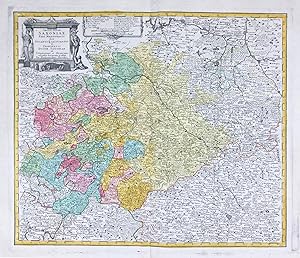
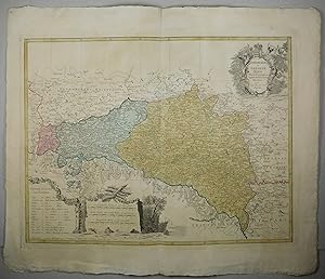
Circuli Sveviae Mappa ex subsidiis Michalianis delineata & a Dno. I. M. Hasio M. P.P." - Schwaben Baden W�rttemberg Bayern Bodensee Stuttgart T�bingen Esslingen Konstanz Lindau Laufbeuren Reutlingen Offenburg Weil Hohenzollern Kempten Allg�u Giengen G�nzburg N�rdlingen Heilbronn Karte map
Published by N�rnberg, Homann Erben, 1743
Seller: Antiquariat Steffen V�lkel GmbH, Seubersdorf, Germany
Seller Rating:
Map
Original altkolorierte Kupferstich-Karte von Johann Baptist Homann (1664-1724) von 1743. -- Blatt-Ma�e: ca. 54 x 62 cm. -- im Randbereich teils etwas fleckig, sonst gut erhalten. || Original old colored engraved map by Johann Baptist Homann (1664-1724) from 1743. || Dies ist ein Original! - Kein Nachdruck! - Keine Kopie! -- This is an original! No copy! - No reprint! la Gewicht in Gramm: 35.
-
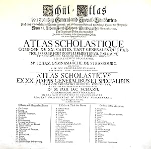
Schul-Atlas von zwantzig General- und Special-Landkarten, nach einer verbesserten Methode illuminirt, und zum bequemen Gebrauch der Anfangs-Gr�nde der Geographie . der Jugend zum Besten also eingerichtet / Atlas scholastique, compos� de XX. cartes . / Atlas scholasticus ex XX. mappis .
Published by N�rnberg: Hom�nnische Officin dat. ,, 1745
Seller: Antiquariat Ruthild J�ger, Lueneburg, Germany
Seller Rating:

(Gr.-Folio). 1 Blatt (mittig gefaltet), 56 x 51 cm. (minimale Randeinrisse sorgf�ltig unterlegt, sonst sehr gut erhalten; small tears in the margins repaired, otherwise in good condition). * Auf dem deutsch/franz�sisch/lateinischen Titelblatt werden die zwanzig im Atlas enthaltenen Landkarten aufgef�hrt. Der Homann'sche Schul-Atlas war konzipiert als Erg�nzung des Geographie-Lehrbuches f�r Schulen aus der Feder des Gymnasialdirektors Johann Jacob Schatz (1720 Rektor in Trarbach, 1728 Direktor und Bibliothekar Gymnasium Eisenach, 1737 Direktor Gymnasium Stra�burg). (#9677AB).
-
Circuli Sveviae Mappa ex subsidiis Michalianis delineata & a Dno. I. M. Hasio M. P.P." - Schwaben Baden W�rttemberg Bayern Bodensee Stuttgart T�bingen Esslingen Konstanz Lindau Laufbeuren Reutlingen Offenburg Weil Hohenzollern Kempten Allg�u Giengen G�nzburg N�rdlingen Heilbronn Karte map
Published by N�rnberg, Homann Erben, 1743
Seller: Antiquariat Steffen V�lkel GmbH, Seubersdorf, Germany
Seller Rating:
Map
Original altkolorierte Kupferstich-Karte von Johann Baptist Homann (1664-1724) von 1743. -- Blatt-Ma�e: ca. 62 x 53 cm. -- mit kleineren hinterlegten Einrissen, sonst gut erhalten. || Original old colored engraved map by Johann Baptist Homann (1664-1724) from 1743. -- with minor deposited tears, otherwise in good condition. || Dies ist ein Original! - Kein Nachdruck! - Keine Kopie! -- This is an original! No copy! - No reprint! la Gewicht in Gramm: 1550.
-

Cursus Rheni a Basilea usque ad Bonnam III Sectionibus exhibitus a Domino G. de l'Isle, . nunc multis modis auctior et emendatior redditus. Sectio I. seu Inferior." - Rhein Rheinlauf Bonn Worms Mainz Rheinfels Darmstadt Koblenz Bingen
Published by N�rnberg um 1740., 1740
Seller: Antiquariat Steffen V�lkel GmbH, Seubersdorf, Germany
Seller Rating:
Map
Original altkolorierte Kupferstich-Karte von ca. 1740. Zeigt den Rheinlauf von Bonn bis Worms. -- Blatt-Ma�e: ca. 56 x 61 cm. -- im unteren Mittelbug hinterlegt, mit alter Knickspur, sonst gut erhalten. || Original old colored copper engraved map from around 1740. -- deposited on the lower centerfod, with old crease, otherwise in good condition. || Dies ist ein Original! - Kein Nachdruck! - Keine Kopie! -- This is an original! - No copy! - No reprint! la Gewicht in Gramm: 1550.
-
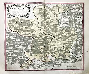
Comitatus Limpurgensis Mandato Speciali imperantium mensuratus" - Grafschaft Limburg Abtsgm�nd Gaildorf B�hlertann Sulzbach-Laufen Adelmannsfelden Baden-W�rttemberg
Published by N�rnberg, 1749
Seller: Antiquariat Steffen V�lkel GmbH, Seubersdorf, Germany
Seller Rating:
Map
Original altkolorierte Kupferstich-Karte von 1749. -- Blatt-Ma�e: ca. 54 x 62 cm. -- im Au�enrand teils etwas fleckig, sonst gut erhalten. || Original old colored copper engraved map from 1749. -- partly somewhat stained on the outer margin, otherwise in good condition. || Dies ist ein Original! - Kein Nachdruck! - Keine Kopie! -- This is an original! - No copy! - No reprint! la Gewicht in Gramm: 30.
-

Ducatus Saxonia dicti Circuli Electoralis Sectio III. / Besondere Land Karte des Herzogth. od. Churkreises Sachsen Welcher aus den Aemtern Annaberg, Beltzig, Bitterfeld, Graefenhainichen, Liebenwerda, Pretsch, Seyda, Schlieben, Schweinitz, Daame, Iuterbock, Gommern und Creis Amt Witemberg zusammen gesetzt ist." - Bitterfeld K�then Bernburg Gr�fenhainichen Dessau Sachsen-Anhalt
Published by N�rnberg, 1752
Seller: Antiquariat Steffen V�lkel GmbH, Seubersdorf, Germany
Seller Rating:
Map
Original altkolorierte Kupferstich-Karte von 1752. -- Blatt-Ma�e: ca. 54 x 62 cm. -- gut erhalten. || Original old colored engraved map from 1752. -- in good condition. || Dies ist ein Original! - Kein Nachdruck! - Keine Kopie! -- This is an original! - No copy! - No reprint! Sprache: Deutsch Gewicht in Gramm: 35.
-
Condition: -. Kupferstich. Altkoloriert. Blatt. 51 x 60 cm. Karte: 46,5 x 55 cm. Papier gleichm��ig gebr�unt u. angestaubt. Oberer Rand Wasserfleck.
-
Circuli Super Saxoniae Pars Meridionalis sive Ducatus Electoratus et Principatus Ducum Saxoniae" - Sachsen Halle Leipzig Dresden Chemnitz Karte map
Published by N�rnberg, Homann Erben, 1740
Seller: Antiquariat Steffen V�lkel GmbH, Seubersdorf, Germany
Seller Rating:
Map
Original altkolorierte Kupferstich-Karte von Johann Baptist Homann (1664-1724) von 1374. -- Mit Potsdam, Zittau, Pilsen, Prag, Leipzig. --Blatt-Ma�e: ca. 54,5 x 65 cm. -- gut erhalten. || Original old colored engraved map by Johann Baptist Homann (1664-1724) from 1734. -- in good condition. || Dies ist ein Original! - Kein Nachdruck! - Keine Kopie! -- This is an original! No copy! - No reprint! la Gewicht in Gramm: 30.
-
Bohemiae Regnum in XVI Circulos divisum (Le royaume de Boheme divis� en XVI cercles)
Published by Homann
Map
Pas de couverture. Condition: Assez bon. Um 1770; Grenz und Fl�chen kolorierte Kupferstich Karte, in 8 Segmenten auf Leinen aufgezogen, 57X50 cm, Titelkartusche in Latein; am oberen Rande in franz�sischer Sprache; guter Zustand, leichte Benutzungspuren am Rande;
-
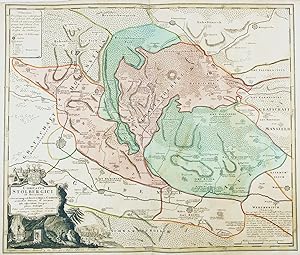
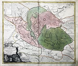
Comitatus Stolbergici ad Hercyniam ceteraumq. ad Illustris. Comites pertinentium Ditionum & terrarum ipsis adjacentium Geographica Descriptio " - Grafschaft Stolberg Harz Neustadt Stra�berg Nordhausen G�ntersberge Sachsen-Anhalt Th�ringen
Published by N�rnberg ca. 1740., 1740
Seller: Antiquariat Steffen V�lkel GmbH, Seubersdorf, Germany
Seller Rating:
Map
Original altkolorierte Kupferstich-Karten von ca. 1740. -- Blatt-Format: ca. 61 x 52 cm -- gut erhalten. || Original colored engraved map from ca. 1740. -- in good condition. || Dies ist ein Original! - Kein Nachdruck! - Keine Kopie! -- This is an original! - No copy! - No reprint! la.
-
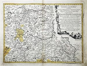
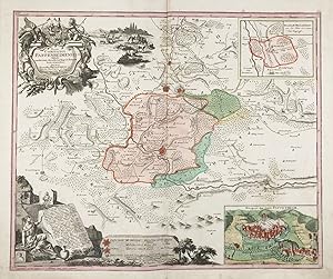
Delineatio Geographica generalis, comprehendens VI. Foliis Singulos Principatus, Comitatus Ditiones, Dynastias omnes quotquot Imperio Serenissimi Principis Landgrafii Hasso-Darmstadiensis" - Fritzlar Kassel Waldeck Homberg Bad Wildungen Arolsen Korbach Treysa Hessen
Published by N�rnberg ca. 1750., 1750
Seller: Antiquariat Steffen V�lkel GmbH, Seubersdorf, Germany
Seller Rating:
Map
Original altkolorierte Kupferstich-Karte von ca. 1750. -- Blatt-Ma�e: ca. 54 x 62 cm. -- im Mittelbug nur leicht fleckig, sonst gut erhalten. || Original old colored copper engraved map from ca. 1750. -- only slightly stained on the centerfold, otherwise in good condition. || Dies ist ein Original! - Kein Nachdruck! - Keine Kopie! -- This is an original! - No copy! - No reprint! la Gewicht in Gramm: 30.
-
Comitatus Stolbergici ad Hercyniam ceteraumq. ad Illustris. Comites pertinentium Ditionum & terrarum ipsis adjacentium Geographica Descriptio " - Grafschaft Stolberg Harz Neustadt Stra�berg Nordhausen G�ntersberge Sachsen-Anhalt Th�ringen
Published by N�rnberg ca. 1740., 1740
Seller: Antiquariat Steffen V�lkel GmbH, Seubersdorf, Germany
Seller Rating:
Map
Original altkolorierte Kupferstich-Karten von ca. 1740. -- Blatt-Ma�e: ca. 53,5 x 61 cm -- im Au�enrand leicht fleckig, sonst gut erhalten. || Original colored engraved map from ca. 1740. -- slightly stained on the outer margin, otherwise in good condition. || Dies ist ein Original! - Kein Nachdruck! - Keine Kopie! -- This is an original! - No copy! - No reprint! la Gewicht in Gramm: 35.
-
Pas de couverture. Condition: Assez bon. Um 1750.Kolorierte Kupferstichkarte, auf Leinen aufgezogen und in 8 Segmenten geteilt; 50 x 58 cm). am Rande leicht fleckig, leichte Benutzungspuren;
-

Principatus Brandenburgio-Culmbacensis vel Baruthinus Tabula Geographica quoad Partem Superiorem" - Kulmbach Bayreuth Wunsiedel Eschenbach Franken Bayern
Published by N�rnberg ca. 1750., 1750
Seller: Antiquariat Steffen V�lkel GmbH, Seubersdorf, Germany
Seller Rating:
Map
Original altkolorierte Kupferstich-Karte von ca. 1750. -- Blatt-Ma�e: ca. 54 x 62 cm. -- im Au�enrand teils etwas fleckig, sonst gut erhalten. || Original old colored copper engraved map from ca. 1750. -- partly somewhat stained on the outer margin, otherwise in good condition. || Dies ist ein Original! - Kein Nachdruck! - Keine Kopie! -- This is an original! - No copy! - No reprint! la Gewicht in Gramm: 35.
-
Nova comitatus Pappenheimensis ." - Pappenheim Wei�enburg W�lzburg Bellenberg Mittelfranken Bayern
Published by N�rnberg ca. 1740., 1740
Seller: Antiquariat Steffen V�lkel GmbH, Seubersdorf, Germany
Seller Rating:
Map
Original altkolorierte Kupferstich-Karte von ca. 1740 - mit Ansicht der Stadt Pappenheim und einer Karte von der Herrschaft Bellenberg - Blatt-Format: ca.61,5 x 52 cm- gut erhalten. || Dies ist ein Original! - Kein Nachdruck! - Keine Kopie! -- This is an original! - No copy! - No reprint! la.
-
Lubomeriae et Galliciae Regni. Tabula Geographica.
Published by N�rnberg, Homann Erben., 1775
Plattengr�sse:46,5x60 cm. Blattgr�sse: 58x68 cm. Grenz- und fl�chenkolorierte Kupferstichkarte. Mittelfalz. Sammlung Ryhiner 6201 11. - Titelkartusche oben rechts. - Etwas gebr�unt und fleckig. Sprache: n.
-
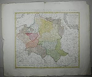
Mappa geographica regni Poloniae ex novissimis quot quot sunt mappis specialibus composita et ad LL. stereographica projectionis revocata a Tob. Mayero S.C.S.
Published by N�rnberg, Homann Erben., 1773
Plattengr�sse:47,5x53 cm. Blattgr�sse: 58,3x68 cm. Grenz- und fl�chenkolorierte Kupferstichkarte. Mittelfalz. Sammlung Ryhiner 6002 4. - Titelkartusche oben rechts. - Franz�sischer Titel oben. - Mit Ein- und Abrissen. Ecken etwas knittrig. Sprache: n.
-
![Seller image for Hungariae ampliori significatu et veteris vel methodicae complexae regna: Hungariae propriae, Croatiae, Dalmatiae, Bosniae, Serviae, Bulgariae, Cumaniae, principatum: Transylvaniae, despotatus: Walachiae, Moldaviae [exclusis ab eadem alienatis Galitia et Ludomiriria] in suas provincias ac partes divisae et quo ad imperanies ex Austriacis, Turcis et Venetis distinctae [juncta tamen propter comoditatem Romania vel Romelia turcica] tabula. for sale by Daniel Thierstein](https://pictures.abebooks.com/inventory/md/md31826390671.jpg)
Hungariae ampliori significatu et veteris vel methodicae complexae regna: Hungariae propriae, Croatiae, Dalmatiae, Bosniae, Serviae, Bulgariae, Cumaniae, principatum: Transylvaniae, despotatus: Walachiae, Moldaviae [exclusis ab eadem alienatis Galitia et Ludomiriria] in suas provincias ac partes divisae et quo ad imperanies ex Austriacis, Turcis et Venetis distinctae [juncta tamen propter comoditatem Romania vel Romelia turcica] tabula.
Published by N�rnberg, Homann Erben., 1744
Plattengr�sse:451,5x62 cm. Blattgr�sse: 59x68,5 cm. Grenz- und fl�chenkolorierte Kupferstichkarte. Mittelfalz. Sammlung Ryhiner 8625 6. - Titelkartusche unten links. Fran�sischer Titel oben. - R�nder etwas fleckig und gebr�unt. Sprache: n.
-
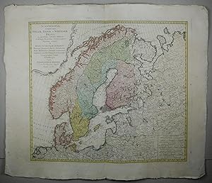
Scandinavia complectens Sveciae, Daniae et Norvegiae regna ex novissimis subsidiis delineata et ad leges projectionis stereographicae legitimae reducta ab Augusto Gottlob B�ehmio electoris saxoniae cohortis architecton milit. mathematico, Societatis oeconomicae Lipsiensis membro honorario et Societatis cosmographiae sodali.
Published by N�rnberg, Homann Erben., 1776
Plattengr�sse:49,5x56,5 cm. Blattgr�sse: 59x69 cm. Grenz- und fl�chenkolorierte Kupferstichkarte. Mittelfalz. Sammlung Ryhiner 5501 42. - Titelkartusche oben links. Sprache: n.
-
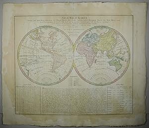
Neue Welt=Karte: welche auf zwoo Kugelflaechen die Haupt=theile der Erde, Inseln, Insel=Gruppen, Theile des Welt=Meers und deren Benennungen, den f�nften Welt=theil und die neuesten Entdekkungen, nach den Karten und Reisebeschreibungen der ber�hmtesten Seefahrer und Gelehrten unsres Zeit=alters, der Herren Cook, Forster, Pallas, u.a.m. nebst einer kurzen Erklaerung enthaelt.
Published by N�rnberg, Homann Erben., 1784
Plattengr�sse:48,5x59 cm. Blattgr�sse: 58x68,5 cm. Grenz- und fl�chenkolorierte Kupferstichkarte. Mittelfalz. Sammlung Ryhiner 1103 6. - Mit einer Graden-Tafel und Meilen-Maas. - Fleckig und gebr�unt. Sprache: n.
-
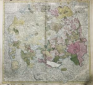
Repraesentationem Circuli Saxonici Inferioris
Publication Date: 1784
"Repraesentationem . Circuli Saxonici Inferioris". Altkol. Kupf.-Kte. nach F. L. G�ssefeld bei Homann Erben, 1784. Mit franz�s. Kopftitel ("Representation de Cercle de Bas-Saxe"), Titelkart. und Meilenzeiger. 50:51,5 cm. A decorative map bounded by the cities Hamburg, Bremen, Hameln, G�ttingen, Magdeburg and Rostock.
-

Reduction der grossen Postkarte von XVI Bl�ttern, nach welcher jeder verlangte Post-Cours leicht und geschwind gefunden wird und wornach auch die XVI
Published by Artist: Homann Erben ( - 1780 ) Nuremberg ; issued in: Nuremberg ; ca: 1786; - Johann Babtiste Homann (1664-1724) was born in Oberkammlach the Electorate of Bavaria Although educated at a Jesuit school and preparing for an ecclesiastical career he eventually converted to Protestantism and from 1687 worked as a civil law notary in Nuremberg He soon turned to engraving and cartography; in 1702 he founded his own publishing house Homann acquired renown as a leading German cartographer and in 1715 was appointed Imperial Geographer by Emperor Charles VI Giving such privileges to individuals was an added right that the Holy Roman Emperor enjoyed In the same year he was also named a member of the Prussian Academy of Sciences in Berlin Of particula, 1724
Seller: Antique Sommer& Sapunaru KG, M�nchen, Germany
Seller Rating:

Technic: Copper print; colorit: colored; condition: Perfect condition, size (in cm): 21 x 22,5 cm; - Detailed oversigt map of a German post way map of 1780. This map is part of a big folded postway mapof Homann.
-
Mappa Geographica Comitatus Oettingensis : in Circulo Suevico siti, prout ille continet Principatum hodiernum Oetingensem ut & Comit. Oetingano Oetingensem & Oetingano Wallersteinensem & Comit. Oeting. Balderensem similiter Territoria urbium Imperial. Nordl. Dunkelsbuhl & Bopfing atque alias adiac. regiones " - Grafschaft Oettingen N�rdlingen Bopfingen Wending Wei�enburg Dinkelsb�hl Donauw�rth Treuchtlingen
Published by N�rnberg, 1744
Seller: Antiquariat Steffen V�lkel GmbH, Seubersdorf, Germany
Seller Rating:
Map
Original altkolorierte Kupferstich-Karten von 1744. -- Blatt-Format: ca. 61 x 52 cm -- am oberen Rand teils etwas fleckig, sonst gut erhalten. || Original colored engraved map from 1744. -- with some staining on the upper margin, otherwise in good condition. || Dies ist ein Original! - Kein Nachdruck! - Keine Kopie! -- This is an original! - No copy! - No reprint! la.